This website uses cookies, which are small text files that the website puts on your device to facilitate operation. Cookies help us provide a better service to you. They are used to track general user traffic information and to help the website function properly.
Feature count in area: 115, by county: Wicklow: 108, Kildare: 4, Wexford: 2, Carlow: 3, of which 1 is in both Wexford and Wicklow, of which 1 is in both Carlow and Wicklow,
OSI/LPS Maps: 28B, 55, 56, 61, 62, AWW, EW-DM, EW-LG, EW-WE, EW-WS
Highest Place: Lugnaquilla 924.7m
Starting Places (205) in area Wicklow: 1916 Memorial Car Park, Aghavannagh Ow Bridge, Aghowle Wood, Altidore Wood Entrance, Annacurra National School, Annalecka Bridge, Asbawn Brook L8350, Aughrim National School, Ballard Road, Ballinabarny Gap, Ballinagappoge Bridge Layby, Ballinagappoge Mountain Hairpin, Ballinagore, Ballinahinch Wood, Ballinastoe MBT CP, Ballinastraw South, Ballineddan Upr Fork, Ballinfoyle Upr Cross, Ballycoog, Ballycreen Brook Bridge, Ballycumber, Ballycumber Bridge, Ballycumber Lane, Ballycumber Wicklow Way, Ballylerane, Ballylow Bridge, Ballylusk Quarry, Ballymanus Lane, Ballymoyle Shooting Lodge, Ballynultagh Gap, Ballynultagh Lane, Ballyreagh Wood, Ballyross Forest, Ballysmuttan Long Stone, Baravore, Barnbawn South, Barranisky North, Barranisky West, Bohilla Land Roundabout, Bohilla Lane Mid, Boranaraltry Bridge, Bray Harbour, Brewel West, Brittas Bay North CP, Buckroney Sand Dunes CP, Bus Terminus, Camera Hill Track Cross, Castletimon Wood North, Clara Vale, Clone House Road, Clonegal, Cloon Wood Cp, Coate Bridge, Coolballintaggart Ledge, Coolbawn House Lane, Cransillagh Brook , Crone Wood CP, Crossbridge, Crossoona Rath, Cummer Wood South, Curtlestown Wood CP, Deputy's Pass CP, Derralossary Church, Derry River Bridge, Devil's Glen CP, Devil's Glen Wood, Djouce Wood Calary, Djouce Wood Lake, Djouce Wood Long Hill, Donard, Donnelly's Lane Car Sales, Drumgoff Forest, Dunranhill North, Dunranhill SE, Dunranhill South, Dwyer McAllister Cottage CP, Enniskerry, Fentons Pub, Fitzsimons Park GAA, unuseableFlemings Footbridge Glen Rd, Gap Pub, Gap Road, Glen Beach CP, Glen of the Downs CP, Glenbride Lane, Glenbride Lodge, Glencree Reconciliation, Glendalough, Glenealy GAA, Glenmacnass Tonelagee CP, Glenmalure Hostel, Glenmalure Lodge, Glenmalure Waterfall, Glenview Hotel, Gowle House, Great Sugar Loaf CP, Grove Bar, Heffernans Well Wood, Hill View, Hollywood Glen, JB Malone CP, Johnnie Fox Pub, Keadeen NE trail, Keadeen Trailhead, Kevins Way Footbridge, Kilbride Army Camp Entrance, Kilcandra South, Kilcommon View, Killalongford Wood, Kilmacrea Cross Roads, Kilranelagh House Gate, Kilruddery Car Park, Kilruddery Cottages, Kings River, Kippure Bridge, Kippure Estate, Kippure Transmitter Gate, Knickeen Cross, Knocknaboley Lane Leeraghs Bog, Knocknaboley Lane Stone Cottage, Knockrath Little, Knockree west, Kyle Loop North, Lackan Wood S, Lake Dr Fraughan Brook, Lake Drive, Lake Park Cross, Lake View Pub, Laragh Free Car Park, Laragh NSch, Lead Mines CP, Liffey Bridge, Liffey Head Bridge, Lough Bray Lower, Lough Bray Upper, Lough Tay North Viewing Point, Lough Tay Wicklow Way CP, Luglass Lane L97561, Lugnagun Track, Macreddin Village, Mangans Lane, Military Road Carrigshouk Hill, Military Road Inchavore River Nth, Military Road Inchavore River Sth, Military Road NW Lough Tay, Military Road Ballyboy Bridge, Military Road Cloghoge Brook, Military Road Croaghanmoira, Military Road Fananierin, Military Road LaraghWicklow Way, Military Road Slieve Maan, Monspolien Bridge, Moortown House, Mountain Rescue HQ, Muskeagh Little Wood, Nahanagan Lough NE, Novara Avenue, Bray, Oiltiagh Brook Knickeen, Old Bridge Cross, Old Bridge Scouts , Old Wicklow Way entrance, Paddock Hill SE, Pier Gates CP, Powerscourt Waterfall CP, Putland Road, Quintagh East, Raheen Park CP, Raheenleagh East, Railway Walk CP, Rathdrum Railway Station, Rednagh Wood, Rocky Valley, Roundwood, Sally Gap, Sally Gap N, Seefin Trailhead, Seskin SE, Shankill Tributary Bridge, Shay Elliott, Sheepshanks Bridge, Shillelagh, Slievecorragh Track, Slievefoore South, Sraghoe Brook, St John's Church, St Kevins Chair, St Kevins Church, St Kevins Way R756, Stone Circle Bridge, Stookeen South, Stranahely Wood, Stranakelly Cross Roads, Tallyho, Templeboden, Tithewer, Tomcoyle L, Tomriland Wood, Toor Brook, Trooperstown Hill Access, Turlough Hill CP, Upper Lake CP, Vallymount GAA CP, Vartry Reservoir Upper, Zellers Pub
Summits & other features in area Wicklow: Cen: Glendalough North: Brockagh Mountain 556.9m, Brockagh Mountain NW Top 549.5m, Brockagh Mountain SE Top 471.7m, Camaderry East Top 677.3m, Camaderry Mountain 698.6m, Conavalla 734m, Tomaneena 682.4m Cen: Glendalough South: Carriglineen Mountain 456.6m, Cullentragh Mountain 510m, Derrybawn Mountain 476.1m, Kirikee Mountain 474.5m, Lugduff 653.2m, Lugduff SE Top 638m, Mullacor 660.7m, Trooperstown Hill 430m N Cen: Tonelagee: Carrignagunneen 561m, Fair Mountain 571.2m, Stoney Top 713.7m, Tonelagee 815.8m, Tonelagee E Top 668m, Tonelagee South-East Top 545.8m NE: Bray & Kilmacanogue: Bray Head Hill 238.9m, Carrigoona Commons East 242m, Downs Hill 372.9m, Great Sugar Loaf 501.2m, Little Sugar Loaf 342.4m NE: Djouce: Djouce 725.5m, Knockree 342.1m, Maulin 570m, Tonduff 642m, Tonduff East Top 593m, War Hill 684.8m, White Hill 631.1m NE: Fancy: Ballinafunshoge 480m, Kanturk 527.4m, Knocknacloghoge 532.4m, Luggala 593.3m, Robber's Pass Hill 508.9m, Scarr 640m, Scarr North-West Top 559.8m, Sleamaine 430m NE: Vartry: Ballinacorbeg 336m, Ballycurry 301m, Dunranhill 342m, Mount Kennedy 365.9m NW: Blessington: Carrigleitrim 408m, Lugnagun 446.2m, Slieveroe 332m, Sorrel Hill 599.5m NW: Mullaghcleevaun: Black Hill 602.2m, Carrigshouk 572.5m, Carrigvore 682.4m, Duff Hill 720.8m, Gravale 719m, Moanbane 703m, Mullaghcleevaun 846.7m, Mullaghcleevaun East Top 796m, Silsean 698m S: Aughrim Hills: Cushbawn 400m, Killeagh 249m, Moneyteige North 427m, Preban Hill 389m S: Croaghanmoira: Ballinacor Mountain 529.3m, Ballycurragh Hill 536m, Ballyteige 447m, Carrickashane Mountain 508m, Croaghanmoira 662.3m, Croaghanmoira North Top 579.5m, Fananierin 426m, Slieve Maan 547.8m, Slieve Maan North Top 546.1m S: Croghan Kinsella: Annagh Hill 454m, Croghan Kinsella 606m, Croghan Kinsella East Top 562.1m, Slievefoore 414m S: Shillelagh Hills: Lakeen 357m, Monaughrim 206m, Seskin 344m, Stookeen 420m S: Tinahely Hills: Ballycumber Hill 429.7m, Eagle Hill 296m, Muskeagh Hill 398.2m SE: Wicklow South East: Ballinastraw 284m, Ballyguile Hill 188m, Barranisky 280m, Carrick Mountain 381m, Collon Hill 238m, Kilnamanagh Hill 217m, Westaston Hill 270m W: Baltinglass: Ballyhook Hill 288m, Baltinglass Hill 382m, Carrig Mountain 571m, Carrigeen Hill 298m, Cloghnagaune 385m, Corballis Hill 258m, Keadeen Mountain 653m, Spinans Hill 409m, Spinans Hill SE Top 400m, Tinoran Hill 312m W: Cen Lugnaquilla: Ballineddan Mountain 652.3m, Benleagh 689m, Camenabologue 758m, Camenabologue SE Top 663m, Cloghernagh 800m, Corrigasleggaun 794.6m, Lugnaquilla 924.7m, Slievemaan 759.7m W: Donard: Brewel Hill 222m, Church Mountain 544m, Corriebracks 531m, Lobawn 636m, Slievecorragh 418m, Sugarloaf 552m, Table Mountain 701.7m, Table Mountain West Top 563m
Note: this list of places may include island features such as summits, but not
islands as such.
Gravale, 719.0mMountain Droibhéal A name in Irish,
Place Rating ..
(Ir. Droibhéal [PNCW], 'difficult passage'), Wicklow County in Leinster province, in Arderin, Vandeleur-Lynam, Irish Highest Hundred Lists, Gravale is the 100th highest place in Ireland.
Grid Reference O10489 09421,
OS 1:50k mapsheet 56 Place visited by: 578members, recently by: jackos, Deirdreb, rhw, Sophie-Hayes, MeabhTiernan, Paddym99, garybuz, orlaithfitz, maoris, davidrenshaw, Prem, Carolineswalsh, knightsonhikes, ConMack23, Nailer1967
I visited this place: NO (You need to be a logged-in member for this.)
Longitude: -6.350288, Latitude: 53.124177, Easting: 310490, Northing: 209421,
Prominence: 125.8m, Isolation: 1.6km ITM: 710414 709453 Bedrock type: Granite with microcline phenocrysts, (Type 2p microcline porphyritic) Notes on name: Eoin Mac Neill believed that the name Drobeóil, mentioned in the Metrical Dindshenchas and seemingly referring to a pass, had survived in the mountain name Gravale (JRSAI lxv, 14). On Nevill's map of 1760 the high ground W of Gravale is marked as Lavarna. Price says that this is pronounced Lavarnia and is derived from Leath-Bhearna. On the Downshire Estate map of 1806 Lavarna Gap is marked on the ridge above Lavarney Spout, between Gravale and Duff Hill. Price comments that this was a route from Lough Dan to Blessington.
Short or GPS IDs, 6 char: Grvl, 10 char: Gravale Linkback: https://mountainviews.ie/summit/97/
Gallery for Gravale (Droibhéal) and surrounds
Summary
for Gravale (Droibhéal):
A rounded boggy top on the Sally Gap to Mullaghcleevaun ridge
Summary created by markmjcampion, Colin Murphy, simon3
2023-09-11 13:09:25
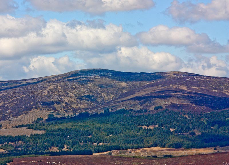
Picture: Gravale from the SE
Although comparitively high, Gravale lacks much excitement although views particularly to the south towards Laragh and SW towards Mullaghcleevaun are worthwhile. No difficulties apart from finding the trail through the heather in low cloud.
NE. From the NE park near the Sally Gap (SalGp (O13040 10971)). Ascend Carrigvore by heading a couple of hundred metres down the road to the NW, all the time keeping an eye out for a fairly obvious track to the left. After summiting Carrigvore drop down to its SW col before ascending to the top of Gravale. Allow 1.5 hrs to the summit.
SE. For a quick route up start at A (O12045 08287) on the road south out of the Sally Gap. Allow 45 mins+
S. There is also parking at Inch N (O11366 07319) and there is a fairly quick route to the summit from here too. Follow track/1478 for an easy 7k loop with 435m ascent.
NW Access is also possible by starting at the Coronation Plantation. Park near SrHoe Bk (O09693 13564) and follow the river due south to approx. B (O09643 11878) before heading up the feint NNW spur of Gravale. There's a couple of hours walking in this as the ground underfoot can be heathery and tussocky.
Track/2821 and track/2355 are long multi-peak loops with lots of ascent and track/4284 is a long linear track that would require a car split.
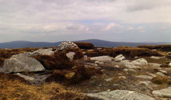
Picture: Forelorn cairn with Kippure in background
On the way to ...
by march-fixer
22 May 2012
This hill looks as if its arms are supported by the two neighbours. It does not have a lot going for it other than really excellent views down the valley towards Laragh. The approaches from both Carrigvore and Duff Hill leave a lot to be desired, with soft boggy saddles which will test your nimbleness at avoiding bog hags and wet peat trenches.
The summit is subject to a fair bit of erosion which leaves the summit cairn looking sorry in a field if boulders. The best reason to be up here is that you are either ... coming or ... going! Linkback: mountainviews.ie/summit/97/comment/6814/
Read Less
Read More
sinbadw on Gravale
by sinbadw
17 Jan 2005
We made our way from the summit of Carrigvore down into the saddle and up the slope to gravale slowly and torturously. The peat trenches were so numerous that we gave up trying to find our way over and around them and instread experimented with the non-newtonian nature of the liquid peat found therein. sometimes the approach of walking quickly across it paid off, other times we were less lucky. I was delighted to finally reach the top, stop briefly at the cairn and take shelter for a quick snack before heading towards Duff Hill. Linkback: mountainviews.ie/summit/97/comment/1426/
Read Less
Read More
Geo on Gravale
by Geo
23 Mar 2009
Following on from my comment on Carrigvore. From Sally Gap via Carrigvore with good underfoot conditions but thick mist about an hour's walk from the Gap. I was anxious to top this hill as it was on the top 100 highest and I'm still trying to get these done! Not the most exciting place on earth in mist but thankfully later on the return journey we saw the views as they unfolded through the haze. Relatively easy to get to and a nice part of Wicklow for people beginning to walk as its relatively easy going as long as there hasnt been recent wet weather and there are no treacherous slopes nearby if mist should descend. Topped by a summit cairn which may take a little bit to find as the top is relatively flat and uses its peat hags to hide it! Linkback: mountainviews.ie/summit/97/comment/3671/
Read Less
Read More
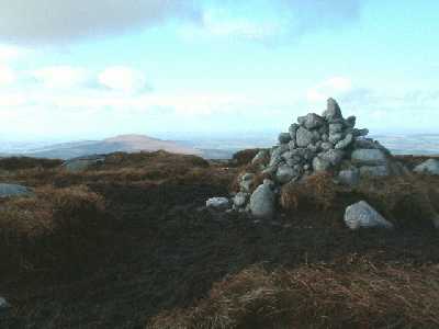
GWPR on Gravale
by GWPR
20 Feb 2003
Summit Cairn, Gravale with Sorrel in the background. Dull itself but with nice views to Sorrel and
Mullagahcleevaun. Linkback: mountainviews.ie/summit/97/comment/334/
Read Less
Read More
nohoval_turrets on Gravale
by nohoval_turrets
21 Oct 2002
Really not much to recommend this apart from the fact that it can lead to Mullaghcleevaun. Carrigvore, Gravale and Duff are very much alike, and a walk with all three really lacks variety. Linkback: mountainviews.ie/summit/97/comment/161/
Use of MountainViews is governed by conditions and a privacy policy.
Read general information about the site. Opinions in material here are not necessarily endorsed by MountainViews.
Hillwalking is a risk sport. Information in comments, walks, shared GPS tracks or about starting places may
not be accurate for example as regards safety or access permission. You are responsible for your safety and your permission to walk.
See the credits and list definitions.


 Our Facebook page.