Cookies.
This website uses cookies, which are small text files that the website puts on your device to facilitate operation. Cookies help us provide a better service to you. They are used to track general user traffic information and to help the website function properly.
Features
Nearby features appear when you click the map.
Declutter tracks on map.
Place Search
Video
X
Pub: by
Wexford Area , N: Bunclody  Subarea
Feature count in area: 14, all in Wexford, OSI/LPS Maps: 61, 62, 68, 69, 76, 77, EW-B, EW-B
Highest Place: Slieveboy 420m

Starting Places (16) in area Wexford:
Askamore Cemetery, Ballymore Wood, Clone Strand, Clonegal, Coolmelagh Forest CP, Cummer Wood South, Gibbet Hill West, Mary Neal's Spout, Mount St Benedict's School, R746 Half Way House, Scroughmore Cross W, Slieveboy NE, Slieveboy SE, St John's Church, Tarahill House, Vinegar Hill

Summits & other features in area Wexford:
N: Bunclody: Kilmichael Hill 269.3m
N: Bunclody : Gibbet Hill 315m, Kilcullen Hill 218m, Slieveboy 420m
N: Enniscorthy  : Oulart Hill 179m, Vinegar Hill 116.6m
NE: Wexford East : Carrigroe Hill 232m, Tara Hill 253m
S: Wexford South: Bree Hill 179m, Camaross Hill 181m, Forth Mountain 237m
SW: New Ross Hills : Carrickbyrne Hill 233m, Lacken Hill 193m, Slievecoiltia 268.5m

Note: this list of places may include island features such as summits, but not islands as such.
Rating graphic.
Gibbet Hill, 315m Hill Cnoc na Croiche A name in Irish,
Place Rating ..
(poss. Ir. ‡Cnoc na Croiche [PDT], 'hill of the gallows'), Wexford County in Leinster province, in Binnion Lists, Gibbet Hill is the second highest hill in the Wexford area and the 1124th highest in Ireland.
Grid Reference S94684 59126, OS 1:50k mapsheet 68,69
Place visited by: 40 members, recently by: jimhoare, Jonesykid, MartaD, maitiuocoimin, loftyobrien, conormcbandon, Barry28213, PaulNolan, molrally, chalky, jlk, kernowclimber, mcrtchly, eamonoc, Trailtrekker
I visited this place: NO (You need to be a logged-in member for this.)
Longitude: -6.600939, Latitude: 52.675415, Easting: 294684, Northing: 159126, Prominence: 212m,  Isolation: 6.5km, Has trig pillar
ITM: 694612 659168
Bedrock type: Dark blue-grey slate, phyllite & schist, (Maulin Formation)
Notes on name: The Irish form Cnoc na Croiche is not attested for this name. It has been borrowed from the townland of Gibbethill in Co. Waterford.
  Short or GPS IDs, 6 char: GbtHl, 10 char: Gibet Hil

Linkback: https://mountainviews.ie/summit/938/
Gallery for Gibbet Hill (Cnoc na Croiche) and surrounds
No summary yet for this place .
Member Comments for Gibbet Hill (Cnoc na Croiche)
Comment create / edit display placeholder

            MountainViews.ie picture about Gibbet Hill (<em>Cnoc na Croiche</em>)
Picture: Dusk on the summit with Blackstairs in the distance
Loads of Fun - No Furze
by Trailtrekker 2 Jan 2022
Tackled this as the last of the four Wexford North hills, all done on the day of the winter solstice and this was the one that I enjoyed most. Travelling in the footsteps of previous commentators I also started at Gib Hl W (S939 591) along the route that Wicklore had pioneered. I drove up to the the Coillte gate that was firmly closed. Being careful, my low slung old Volvo made it up without incident, although I wouldn't recommend it. With the dusk drawing in I half considered blocking the aforementioned gate, something I would never do. I could hear shouting in the distance and feared this maybe some farmer seeing me from a lower field and this banished any thoughts of dodgy parking. I later discovered that it was a sheep farmer and his dog rounding up their flock. I parked further down at the road as Geansai had done also.

Once through the Coillte gate/barrier you follow the track right, turning left at the first junction it is a simple case of following the track the whole way to the small gap identified by simon3 at 
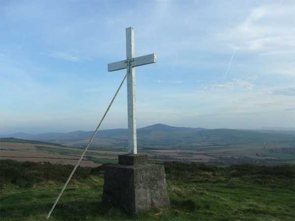
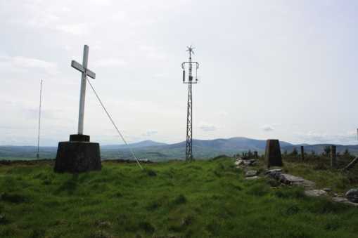
A (S94784 59331) . This track is now pretty well worn and once you reach the end of it you are met with one of the turbines from the newly constructed wind farm. You can still follow the short track along the wall, it was well trodden and furze free on my visit. If you were bold you could cross the gate and follow the wind farm track up to the top field where the summit trig, mast and cross are now joined by another turbine!

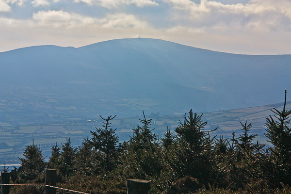
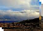
By coincidence, on my way back down I also came across a hare, as well as two lonely looking hen pheasants (maybe having lost their partners since the shooting season opened). As I descended, the gloom lifted briefly and the last minutes of sunshine on the shortest day of the year lit up the Blackstairs in front of me. With the recent rain and the light the whole scene in front of me was a mix of vibrant colours and truly beautiful.

On completion of my walk I did some reconnaissance around the hill to find the access road to the wind farm. It is very easy to find at CulMela (S96072 60362) on the R746. There is ample parking here. A Coillte board carries a map of all the tracks on the hill and there are parallel tracks heading off up the hill; one Coillte and the other relating to the wind farm. Although slightly longer I would be pretty certain that the summit can be reached from here without ever having to leave a gravel track!

On a personal note, this brought me to 98 new summits for the year. On to Greenoge for 99, to leave just the Great Sugar Loaf to complete the tonne and my local 100 on New Year's Eve! Linkback: mountainviews.ie/summit/938/comment/15287/
Read Less
Read More

            MountainViews.ie picture about Gibbet Hill (<em>Cnoc na Croiche</em>)
Picture: Mount Leinster looms large from Gibbet Hill
simon3 on Gibbet Hill
by simon3 23 Feb 2010
One thing you may notice in a number of places on this hill is some fine stone walls made out of flattish pieces of rock. In the eighteenth century there was a slate quarry on the hill which is presumably the reason.

The least prickly way we found up is to start at the same entrance as mentioned by Wicklore and then go to A (S94784 59331) where there is an unpromising looking track leading SE. Take this and after about 90m of not-great-but-passable track beside an old wall you will emerge into open ground. Go around 230m SW along the fence and you will be at the top. Linkback: mountainviews.ie/summit/938/comment/4423/
Read Less
Read More

            MountainViews.ie picture about Gibbet Hill (<em>Cnoc na Croiche</em>)
Picture: Looking East from the Summit
Furze Free
by Geansai 13 Nov 2011
I followed in Wicklore's footsteps but I didn't drive up as far as the coillte gate as the track was very bad. I just parked at the junction of the track and the road, where there's enough space to park well away from a farm gate opposite, so as not to block it while remaining well off the main road and not blocking the junction. The way is is signposted with arrows from the coillte gate. Give the beech tree corridor a miss ( There's furze at the end of it before you get back on the track ) and stay on the track uphill. You'll come to a crossroads of sorts- the track you're on veers sharply to the right with arrow signposts indicating thats the way you should go. Furthur uphill you'll come to a junction. Turn left and after several hundred yards, watch out for a small mucky track going to the right, and uphill through the vegatation. Horses have been up here and its nothing but muck which you can avoid by dancing round the grassy edges. At the end of it by a fence you can see the summit to your right and its an easy stroll over. The town of Carnew can be seen to the north. On the way down a horse and rider emerged downhill from the beech tree corridor and continued straight down after crossing the track. I was wondering how they could ride horses up the narrow mucky track but this guy made it look easy. Linkback: mountainviews.ie/summit/938/comment/6623/
Read Less
Read More

            MountainViews.ie picture about Gibbet Hill (<em>Cnoc na Croiche</em>)
Picture: Summit of Gibbet Hill with Blackstairs beyond
wicklore on Gibbet Hill
by wicklore 17 May 2009
Exploring the minor roads that circle Gibbet Hill I found a track that branches off in a southerly direction at Gib Hl W (S939 591). Just up this track there is a gate on the left. The gate seems to be a Coillte access point, and it was possible to park there. Through the gate I turned left on a track. The hill slopes up to the right and is covered in furze. After a few minutes on the track I came to a line of beech trees heading up the hill. Using the trees as a corridor I took a shortcut up the hill and followed them up until I rejoined the track above. Beneath the copse of beech trees was a delightful bed of bluebells that stretched up the hill. After reaching the upper track at B (S941 588) I left it to head directly uphill again. This time there were no trees to provide a protective corridor and some pain was experienced negotiating the furze. I soon reached another upper track, and continued directly uphill through more rough ground. I eventually reached a fence at C (S944 589) and turned left to follow it. If anyone is repeating this route I would suggest you cross the fence here and follow it to the summit keeping the fence on your left. This is because the ground on the side of the fence I was on became dense with thorny furze and I couldn’t find anywhere to cross the fence to the clearer ground on the other side. I had to endure another 15 minutes of painful walking as I followed the fence to the summit. The summit area (D (S946 591)) is a grassy field mixed with (surprise surprise!) more furze. There are two little masts at the summit, and one appears to be a weather station. There is a trig pillar, and finally there is a large white cross on a concrete base. Views are expansive to the east, south and west. The best views are of the Blackstairs Mountains. Their entire span is visible from north to south. Leaving the summit I headed back down to the track. On reaching it I turned right and followed it along until I found what appeared to be a quad bike track heading directly steeply downhill. I followed this all the way down to the track near the car, startling a hare (and myself) along the way. Gibbet Hill was a nice walk that took just over an hour. I would go back just to see the carpet of bluebells, thriving quietly away beneath the beech trees. Linkback: mountainviews.ie/summit/938/comment/3765/
Read Less
Read More

            MountainViews.ie picture about Gibbet Hill (<em>Cnoc na Croiche</em>)
Picture: Wind farm on Gibbet Hill with Slieveboy behind.
Building site at the top.
by paddyhillsbagger 23 Feb 2013
Walked Gibbet Hill as part of completing the Nth Wexford area and found the top relatively easily by following the other commenters routes. What they didn't come across was the building site at the top for a new wind farm. A stones throw from the trig are the works offices, an access road and the foundations for a turbine. The trig and nearby cross look swamped and abandoned in a sea of earth works.This work is ongoing as of Feb 2013 and access will possibly be restricted during construction. Linkback: mountainviews.ie/summit/938/comment/14936/
Read Less
Read More
EDIT Point of Interest
text
Videos
(none available)
Recent Contributions
x
Conditions and Info
Use of MountainViews is governed by conditions and a privacy policy.
Read general information about the site.
Opinions in material here are not necessarily endorsed by MountainViews.
Hillwalking is a risk sport. Information in comments, walks, shared GPS tracks or about starting places may not be accurate for example as regards safety or access permission. You are responsible for your safety and your permission to walk.
See the credits and list definitions.

OSi logo
OSNI/LPS logo
Open Street Map
(Various variations used.)
British summit data courtesy:
Database of British & Irish Hills