Cookies.
This website uses cookies, which are small text files that the website puts on your device to facilitate operation. Cookies help us provide a better service to you. They are used to track general user traffic information and to help the website function properly.
Features
Nearby features appear when you click the map.
Declutter tracks on map.
Place Search
Video
X
Pub: by
Sperrin Mountains Area , SE: Cookstown Hills Subarea
Feature count in area: 64, by county: Derry: 34, Tyrone: 39, of which 9 are in both Derry and Tyrone, OSI/LPS Maps: 12, 13, 6, 7, 8
Highest Place: Sawel 678m

Starting Places (21) in area Sperrin Mountains:
Altinure Road, Banagher Glen Nature Reserve, Barnes Gap Car Park, Crocknakin, Drumnaspar Picnic CP, Glenchiel Road, Glenedra Bridge, Glenelly Road, Parkreagh, Goles Road, Lough Ouske, Moneyneany Village, Moydamlaght Forest, Moydamlaght Road, Mullaghmore, Mullaghbane, Spaltindoagh, Sperrin Hamlet, Sperrin Heritage Centre, Sperrin Heritage Centre W, Sperrin Road, Barnes Top, Sperrin Road, Glashagh Bridge, Sperrin Road, Sperrin

Summits & other features in area Sperrin Mountains:
E: Magherafelt Hills: Slieve Gallion NE Top 493.6m
E: Magherafelt Hills: Slieve Gallion 526.6m
N: Claudy Hills: Crockdooish 321m, Curradrolan Hill 270m, Eglish 277m, Letterlogher 249m, Mullaghmeash Hill 244m, Slieveboy 259m, Straid Hill 303m
NE Cen: Glenelly North East: Barnes Top 456m, Craigagh Hill 460m, Crockbrack 526.1m, Knockanbane Mountain 441m, Meenard Mountain 620m, Meenard Mtn W Top 480m, Mullaghaneany 627m, Mullaghash 480m, Mullaghsallagh 485m, Oughtmore 569m, Spelhoagh 568m
NE: Glenshane North: Benbradagh 465m, Boviel Top 454m, Carn Hill 448m, Carntogher 464m, Moneyoran Hill 414m
NE: Glenshane South: Bohilbreaga 478m, Coolnasillagh Mountain 423m, Corick Mountain 430m, Crockalougha 407m, Mullaghmore 550m, White Mountain 537m
NW Cen: Glenelly North West: Dart Mountain 619m, Dart Mountain North-West Top 525m, Learmount Mountain 489m, Learmount Mountain South Top 492m, Mullaghasturrakeen 581m, Mullaghcarbatagh 517m, Mullaghclogha 635m, Mullaghclogher 572m, Mullaghdoo 568m, Sawel 678m
NW: Maheramason Hills: Clondermot Hill 220m, Gortmonly Hill 218m, Slievekirk 370m
SE Cen: Glenelly South East: Carnanelly 562m, Carnanelly West Top 503.4m, Mullaghbane 467m, Mullaghturk 416m
SE: Cookstown Hills: Cregganconroe 300m, Fir Mountain 362m, Oughtmore 382m
SW Cen: Glenelly South West: Clogherny Top 408m, Craignamaddy 385m, Crocknamoghil 335m, Mullaghbolig 442m, Spaltindoagh 420m
SW: Mullaghcarn: Curraghchosaly Mountain 416m, Mullaghcarn 542m, Mullaghcarn South Top 525m
SW: Newtownstewart Hills: Bessy Bell 420m, Mullaghcroy 242m
W: Strabane: Balix Hill 403m, Knockavoe 296m, Owenreagh Hill 400m

Note: this list of places may include island features such as summits, but not islands as such.
Rating graphic.
Oughtmore, 382m Hill Ucht Mór A name in Irish,
Place Rating ..
(prob. Ir. Ucht Mór [PDT], 'big mountain-breast'), Tyrone County in Ulster province, in Binnion Lists, Oughtmore is the 994th highest place in Ireland.
Grid Reference H72423 83762, OS 1:50k mapsheet 13
Place visited by: 44 members, recently by: Tricia-Mulligan, garybuz, Paddym99, Sperrinwalker, ElaineM76, pdtempan, Claybird007, wintersmick, Kilcoobin, Oscar-mckinney, Jai-mckinney, Carolyn105, dregish, ei7kh, Hoverla
I visited this place: NO (You need to be a logged-in member for this.)
Longitude: -6.877551, Latitude: 54.696694, Easting: 272423, Northing: 383762, Prominence: 157m,  Isolation: 2.8km
ITM: 672356 883754
Bedrock type: Psammite, (Corvanaghan Formation)

  Short or GPS IDs, 6 char: Ogh382, 10 char: Oughtmo382

Linkback: https://mountainviews.ie/summit/862/
Gallery for Oughtmore (Ucht Mór) and surrounds
No summary yet for this place .
Member Comments for Oughtmore (Ucht Mór)
Comment create / edit display placeholder

            MountainViews.ie picture about Oughtmore (<em>Ucht Mór</em>)
Picture: summit looking to Slieve Gallion
gerrym on Oughtmore
by gerrym 5 Apr 2010
This hill has a personal connection in that my great grandfather Bell owned 400 acres here before selling to the forestry service in the 1950's (for £1 per acre). The remains of the old homestead are still visible, surrounded by mature broadleaf trees amid the pine, and the family return periodically to reconnect.

Parking was at the entrance opp the quarry (A (H737 848)) where loads of room. Follow the good track into the forest until a carpark - turn left uphill on tarred road. Views in the forest stretch to the big Sperrin hills to the N and from here brought the hills of Antrim within reach. Continue uphill at a crossroads past a new gate. The wind bringing the trees alive with creaks and groans of protest.

Take a track forking to the left, where the trees soon thin to show the top of Ougthmore a short distance away. Cross the fence where machinery has been accessing the hill - some turf cutting. Pools of water here were thick with clumps of frog spawn. Fairly straight forward jaunt to top reached in 45 minutes from start. There is a small summit cairn which is certainly dwarfed by the far reaching views. North the line of the high Sperrins, West to the Bluestacks, South to Mullaghcarn, Cuilcaigh, Cooleys, Mournes and East to Belfast and Antrim Hills.

Skiffs of rain peppered the ground for seconds and were gone as i returned to the forest track - returning the way i had come. Detoured to the little loughs at B (H736 857) in hope of catching sight of some siska deer but wasn't to be today. Busy through parts of the forest with plenty of walkers and some mountain bikers but easy to lose yourself here. Linkback: mountainviews.ie/summit/862/comment/4586/
Read Less
Read More

            MountainViews.ie picture about Oughtmore (<em>Ucht Mór</em>)
Picture: Looking south east to (R-L) Slieve Gullion, Camlough Mtn, Slieve Foye and the western edge of the Mo
dr_banuska on Oughtmore
by dr_banuska 11 Jul 2009
I decided to tackle this hill last weekend as it's one of the southermost in the range and closest to where I live. It is somewhat confusing that there are two Oughtmores in the Sperrins: this is the lower and further south of the two. Came with the dog and Discoverer Map 13 - without it I probably never would have even known where it was exactly. Probably the best approach is to head north for several miles off the main Cookstown-Omagh Road, shortly after the turn off for Wellbrook Beetling Mill coming from C'town direction (you seriously will need a map/GPS as even explaining the route is difficult!).

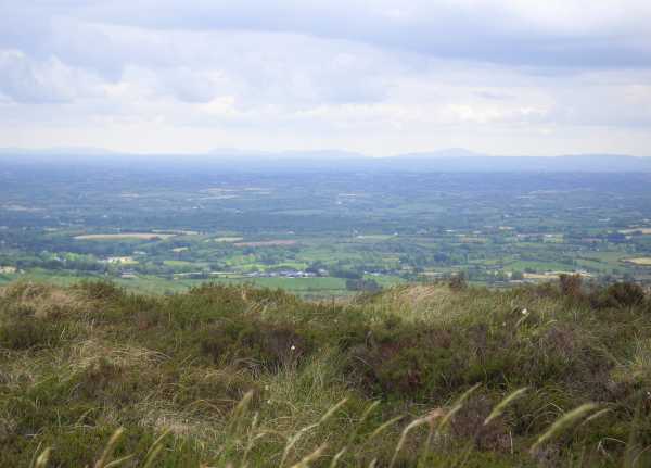
Looks like I parked at the same place as thisbliss: the forest comes into view on the left and there are two tracks opposite and just after a large white house. The left one is surfaced and leads to some old farm buildings and the right, which I took, is an unsurfaced forest track. I followed this for a short time until the start of the forest where there was a wire fence on the right. I walked up along the left side of the wire, easy enough to find a path but quite tough going as you're knee deep in heather most of the time. There are some fine views south and east here: Slieve Gullion, Camlough Mountain, Foye and the full length of the Mournes were clearly visible.

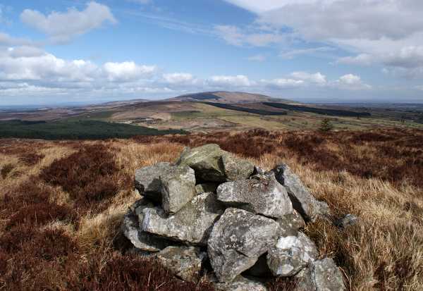
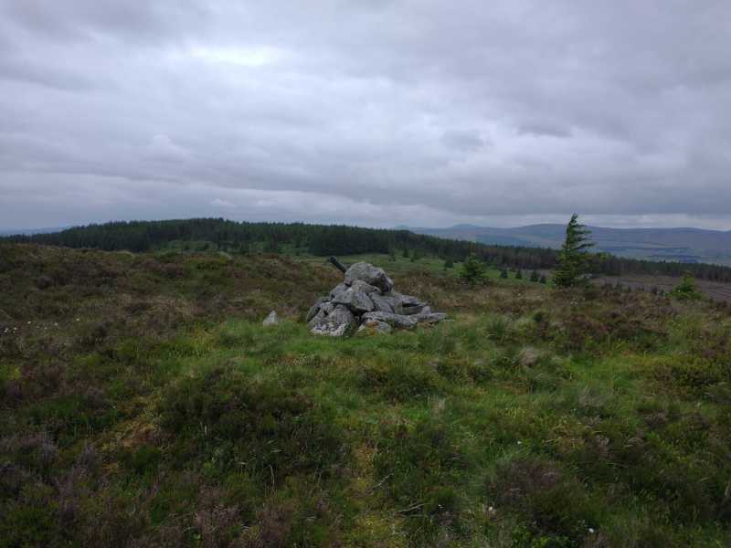
Eventually, once you've reached the top of the forest, the wire turns at a right angle and I followed it to the west for some time, sandwiched between the line of the forest to the left and the wire to the right, until I came to a gate over the main forest track. I climbed over this and followed the track where it forks off to the right towards the summit, a pretty straightforward hike. There is a very small cairn at the peak from where there are stunning panoramic views considering the relatively small height of this hill: besides the ranges already mentioned, I could see Slieve Gallion and part of Lough Fea to the north east, Cookstown, the full length of Lough Neagh and the Belfast Hills to the west; most of the Sperrin range to the north and north west (Sawel and Dart were very prominent); distant peaks that I guessed were the Bluestacks of Donegal; to the south west the table-like profile of Cuilcagh could be seen as well as the south Tyrone/Fermanagh hills such as Brougher, the upland between F'miletown and Fintona and Slieve Divena wind farm near Garvaghy.

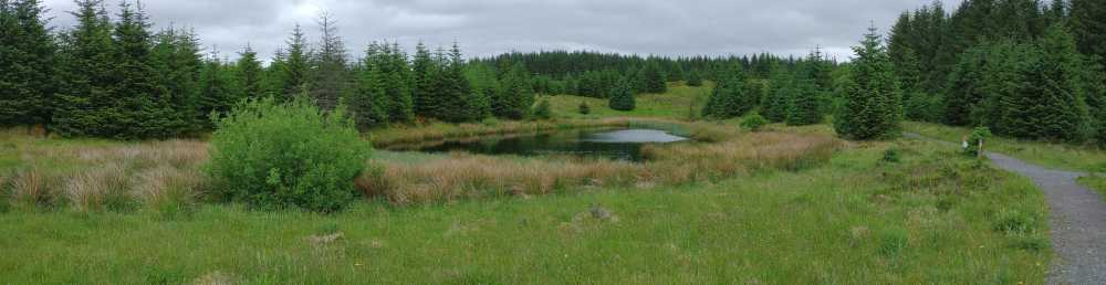
Coming down I returned to the gate and this time followed the track straight down through the forest, which was quite an enjoyable if slightly eery walk; there were some deserted old farm buildings pretty deep in the forest. Eventually I came back to where I had branched off to follow the fence.

A very enjoyable afternoon's walking - I would highly recommend taking this circular route just for variety. Linkback: mountainviews.ie/summit/862/comment/3846/
Read Less
Read More

            MountainViews.ie picture about Oughtmore (<em>Ucht Mór</em>)
Picture: View from the summit cairn of Beleevnamore Mountain (forestry) and towards Carnanelly
Pleasant mix of forest, clearings and open hillside
by pdtempan 25 Jun 2021
Had a couple of hours to spare while my dogs were being groomed at Tullyhogue, so I headed off to bag Oughtmore, which seemed the nearest and most easily accessible peaks in MV. I parked at the forest entrance near the quarry C (H736 849) (there is enough space here to park away from the barrier, allowing access) and followed the route given by gerrym. This takes you on a wide arc through Davagh Forest Park to the north and then south-west, but the tracks are good and progress is fast. Scenery is quite pleasant as planted, mainly coniferous forestry goes, with some nice clearings, where bilberry was in flower, and a small lake. There are quite a few tracks in Davagh Forest designated for mountain bikers only, which I respected and avoided using as a short-cut or leafy alternative. However, it was a Monday lunchtime and I met nobody on foot or bike during the whole trip. I was a little bit uncertain exactly where to leave the path to strike off cross-country to the summit, but after passing a gate and heading slightly downhill, I realised that this was the best access and returned to cross the gate at D (H719 841). It took only another 10 mins across the open hillside (relatively dry on this occasion) to reach the summit, 50 mins in total from the car park. There were good views towards Slieve Gallion and Carnanelly. Having spotted a decent path to the NE of the summit while on the way up, I was tempted to head for this on the descent, but the open hillside soon gave way to tougher ground with higher heather, so it was feasible, but no short cut time-wise. My recommendation would be to return the same way by the good tracks. Linkback: mountainviews.ie/summit/862/comment/23177/
Read Less
Read More

            MountainViews.ie picture about Oughtmore (<em>Ucht Mór</em>)
Scenery in Davagh Forest
by pdtempan 25 Jun 2021
This was one of the most scenic spots on the ascent of Oughtmore. The track visible on the right is marked for mountain bikers only. Linkback: mountainviews.ie/summit/862/comment/23178/
Read Less
Read More

thisbliss on Oughtmore
by thisbliss 2 Nov 2008
Promised myself a climb of this and managed it at the weekend. Parked at entrance to forest track E (H734 844). Walked up the track and where it reaches a crest turned left and set out over open ground. There was still plenty of snow lying about in patches and the ground was swampy so had to pick the steps out. Took about 40 mins to reach the top. Great views for a small mountain. Easily 7 or 8 counties can be seen. Good scenery of the bulk of the sperrins with a scattered coat of snow. Linkback: mountainviews.ie/summit/862/comment/3414/
Read Less
Read More
EDIT Point of Interest
text
Videos


Recent Contributions
x
Conditions and Info
Use of MountainViews is governed by conditions and a privacy policy.
Read general information about the site.
Opinions in material here are not necessarily endorsed by MountainViews.
Hillwalking is a risk sport. Information in comments, walks, shared GPS tracks or about starting places may not be accurate for example as regards safety or access permission. You are responsible for your safety and your permission to walk.
See the credits and list definitions.

OSi logo
OSNI/LPS logo
Open Street Map
(Various variations used.)
British summit data courtesy:
Database of British & Irish Hills