Cookies.
This website uses cookies, which are small text files that the website puts on your device to facilitate operation. Cookies help us provide a better service to you. They are used to track general user traffic information and to help the website function properly.
Features
Nearby features appear when you click the map.
Declutter tracks on map.
Place Search
Video
X
Pub: by
Derrynasaggart Area , SE: Mullaghanish Subarea
Feature count in area: 24, by county: Kerry: 12, Cork: 14, of which 2 are in both Cork and Kerry, OSI/LPS Maps: 79
Highest Place: The Paps East 694m

Starting Places (28) in area Derrynasaggart:
Carrigallisy, Clonee, Dromiscane Castle, Fuhiry Wood, Garrane Bridge, Garries Bridge, Glannafreaghaun Lough N, Glannafreaghaun Lough S1, Glannafreaghaun Lough S2, Gortavehy Lough, Grousemount Wind Farm, Inchamore Woods N, Inchamore Woods W, Kippagh Lough, Knocknabro Wood, Knockullane, Liam Hegarty Monument, Loo River Junction, Lough Murtagh, Millstreet, Mullaghanish Transmitter Gate, Old Rail Level Crossing, Paps Walk S, River Roughty, Rossacroo na Loo Forest, Sillahertane Stream, The Mills Inn, Top of Coom

Summits & other features in area Derrynasaggart:
Cen: Knocknabro: Knocknabro East Top 530m, Knocknabro NE Top 535m, Knocknabro West Top 592m, Knocknagowan 574m
N: Caherbarnagh: Caherbarnagh 681m, Caherbarnagh East Top 549m, Caherbarnagh NW Top 668m, Claragh Mountain 452m, Curracahill 478m
SE: Mullaghanish: Ballyvouskill 401m, Knockacommeen 426m, Knockullane 462m, Knockullane East Top 408m, Mullaghanish 649m, Mullaghanish North-East Top 586.4m, Mullaghanish Far North-East Top 558.5m
SW: Coomagearlahy: Knockbwee 461m, Cummeenboy 442m, Coomagearlahy 506m, Coomagearlahy West Top 462m, Dereenaculling 303m
W: The Paps: Coolcurtoga 425m, The Paps East 694m, The Paps West 690m

Note: this list of places may include island features such as summits, but not islands as such.
Rating graphic.
Knockullane East Top, 408m Hill Cnoc na nUlán (mullach thoir) A name in Irish,
Place Rating ..
For origin of name, see Cnoc na nUlán / Knockullane., Cork County in Munster province, in Carn Lists, Cnoc na nUlán (mullach thoir) is the 908th highest place in Ireland.
Grid Reference W24084 79940, OS 1:50k mapsheet 79
Place visited by: 18 members, recently by: John.geary, Colin Murphy, chelman7, Fergalh, Juanita, CaminoPat, Wildrover, hivisibility, eamonoc, frankmc04, Cobhclimber, thomas_g, three5four0, shaunkelly, pocarbuile
I visited this place: NO (You need to be a logged-in member for this.)
Longitude: -9.105248, Latitude: 51.966883, Easting: 124084, Northing: 79940, Prominence: 42m,  Isolation: 1.6km
ITM: 524052 580000
Bedrock type: Green-grey sandstone & purple siltstone, (Gun Point Formation)
Notes on name: Previously Labbadermody in MV.
  Short or GPS IDs, 6 char: Knc409, 10 char: KncklnEstT

Linkback: https://mountainviews.ie/summit/789/
Gallery for Knockullane East Top (Cnoc na nUlán (mullach thoir)) and surrounds
Summary for Knockullane East Top (Cnoc na nUlán (mullach thoir)): You thought Knockullane was bad?
Summary created by jackill 2010-08-26 15:17:44
Park at Kn'ulane (W22369 80417) where there is a large rough clearing
There is a forest road leading downhill to the southwest from this carpark.
Climb the bank created by the road cutting just as it meets the carpark and follow a rough, wet forest ride for 500 meters uphill.
You will emerge on open hillside covered in rough brown grass hiding a multitude of places that will twist your ankle or drown you.
Keeping a wire fence and the forestry to your left walk to the summit of Knockullane.
The ground does not improve much on the walk to Knockullane E Top, apart from one short section.The summit is located in a clearing just inside the outer edge of the forestry.
Linkback: mountainviews.ie/summit/789/comment/5548/
Member Comments for Knockullane East Top (Cnoc na nUlán (mullach thoir))
Comment create / edit display placeholder

            MountainViews.ie picture about Knockullane East Top (<em>Cnoc na nUlán (mullach thoir)</em>)
Picture: Heading boggily along to Knockullane east
jackill on Knockullane East Top
by jackill 22 Nov 2009
And now for the interesting bit, keep your eyes open when tramping these hills.
The Mullaghanish to Musheramore Mountains SPA comprises a substantial part of the
Boggeragh/Derrynasaggart Mountains. It is divided roughly into two sectors by the R582 road
between Macroom and Millstreet. Most of the site is over 200 m in altitude, rising to heights of
475 m in the eastern sector (Musherabeg) and 462 m in the western sector (Knockullane).
Several important rivers rise within the site, notably the Foherish and Awboy. The site is
underlain by Old Red Sandstone.
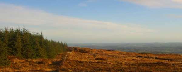
The site consists of a variety of upland habitats, though approximately one-third is afforested.
The coniferous forests include first and second rotation plantations, with both pre-thicket and
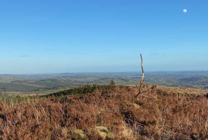
post-thicket stands present. The principal tree species present are Sitka Spruce and Lodgepole Pine. Almost one-third of the site is unplanted blanket bog and heath, with both wet and dry heaths present. The vegetation is characterised by such species as Ling Heather ,Cross-leaved Heath, Bilberry, Common Cottongrass, Deergrass and Purple Moor-grass. The remainder of the site is mostly rough grassland that is
used for hill farming.
This varies in composition and includes some wet areas with rushes and some areas subject to scrub encroachment.
The site is a Special Protection Area (SPA) under the E.U. Birds Directive, of special conservation interest for Hen Harrier.
This SPA is a stronghold for Hen Harrier. A survey in 2005 resulted in 5 confirmed breeding pairs,which represents over 3% of the national total. A similar number had been recorded in the 1998-2000 period. The mix of forestry and open areas provides optimum habitat conditions for this rare bird, which is listed on Annex I of the Birds Directive. The early stages of new and second rotation conifer plantations are the most frequently used nesting sites, though some pairs may still nest in tall heather of unplanted bogs and heath. Hen Harriers will forage up to 5 km from the nest site, utilising open bog and moorland, young conifer plantations and hill farmland that isnot too rank. Birds will often forage in openings and gaps within forests. In Ireland, small birds and small mammals appear to be the most frequently taken prey.
The site also supports a breeding population of Merlin, a species that is also listed on Annex I of
the E.U. Birds Directive. The population size is not well known but is likely to be one or two pairs.
The main threat to the long-term survival of Hen Harriers within the site is further afforestation,
which would reduce and fragment the area of foraging habitat, resulting in possible reductions in breeding density and productivity.
Overall, the site provides excellent nesting and foraging habitat for breeding Hen Harrier and is an important stronghold for the species. Linkback: mountainviews.ie/summit/789/comment/4281/
Read Less
Read More

There is an easier way
by thomas_g 22 Feb 2013
Park at A (W23055 81392) (forest entrance 1-2 cars). Follow the forest road down in the valley keeping right at B (W235 801), follow this road to where it ends at C (W240 802) which has been recently clear felled. Pick your way across about 300 metres of trip hazards and your at the top.
Much much nicer than climbing over the 20 fences that line the bog between Knockullane and Knockullane E. Linkback: mountainviews.ie/summit/789/comment/14931/
Read Less
Read More

            MountainViews.ie picture about Knockullane East Top (<em>Cnoc na nUlán (mullach thoir)</em>)
Picture: Eough hazards to shake a stick at.
Don't take the obvious route.
by Colin Murphy 30 Mar 2022
Having bagged Knockullane, you may be tempted to approach the east top directly. Don't. A mere 1.8km away, yet it is a nightmare of swampy ground, hidden barbed wire, the remnants of clear fell which must be clambered over and various other obstacles. My suggestion is to head back to your car from Knockullane, drive to A (W23055 81392), an follow the forest trail to D (W236 801), where a lesser trail leads directly up the hill and will take you virtually to the top, which is a heathery hump marked only by a stick. It may add 4km to your walk, but it's worth it to avoid the misery of the direct approach. Linkback: mountainviews.ie/summit/789/comment/23462/
Read Less
Read More
EDIT Point of Interest
text
Videos
Users Online
Dee68, TommyMc, JohnFinn, jackos, simon3, keith.dillon
Guests online: 267
Recent Contributions
x
Conditions and Info
Use of MountainViews is governed by conditions and a privacy policy.
Read general information about the site.
Opinions in material here are not necessarily endorsed by MountainViews.
Hillwalking is a risk sport. Information in comments, walks, shared GPS tracks or about starting places may not be accurate for example as regards safety or access permission. You are responsible for your safety and your permission to walk.
See the credits and list definitions.

OSi logo
OSNI/LPS logo
Open Street Map
(Various variations used.)
British summit data courtesy:
Database of British & Irish Hills