This website uses cookies, which are small text files that the website puts on your device to facilitate operation. Cookies help us provide a better service to you. They are used to track general user traffic information and to help the website function properly.
Feature count in area: 115, by county: Wicklow: 108, Kildare: 4, Wexford: 2, Carlow: 3, of which 1 is in both Wexford and Wicklow, of which 1 is in both Carlow and Wicklow,
OSI/LPS Maps: 28B, 55, 56, 61, 62, AWW, EW-DM, EW-LG, EW-WE, EW-WS
Highest Place: Lugnaquilla 924.7m
Starting Places (205) in area Wicklow: 1916 Memorial Car Park, Aghavannagh Ow Bridge, Aghowle Wood, Altidore Wood Entrance, Annacurra National School, Annalecka Bridge, Asbawn Brook L8350, Aughrim National School, Ballard Road, Ballinabarny Gap, Ballinagappoge Bridge Layby, Ballinagappoge Mountain Hairpin, Ballinagore, Ballinahinch Wood, Ballinastoe MBT CP, Ballinastraw South, Ballineddan Upr Fork, Ballinfoyle Upr Cross, Ballycoog, Ballycreen Brook Bridge, Ballycumber, Ballycumber Bridge, Ballycumber Lane, Ballycumber Wicklow Way, Ballylerane, Ballylow Bridge, Ballylusk Quarry, Ballymanus Lane, Ballymoyle Shooting Lodge, Ballynultagh Gap, Ballynultagh Lane, Ballyreagh Wood, Ballyross Forest, Ballysmuttan Long Stone, Baravore, Barnbawn South, Barranisky North, Barranisky West, Bohilla Land Roundabout, Bohilla Lane Mid, Boranaraltry Bridge, Bray Harbour, Brewel West, Brittas Bay North CP, Buckroney Sand Dunes CP, Bus Terminus, Camera Hill Track Cross, Castletimon Wood North, Clara Vale, Clone House Road, Clonegal, Cloon Wood Cp, Coate Bridge, Coolballintaggart Ledge, Coolbawn House Lane, Cransillagh Brook , Crone Wood CP, Crossbridge, Crossoona Rath, Cummer Wood South, Curtlestown Wood CP, Deputy's Pass CP, Derralossary Church, Derry River Bridge, Devil's Glen CP, Devil's Glen Wood, Djouce Wood Calary, Djouce Wood Lake, Djouce Wood Long Hill, Donard, Donnelly's Lane Car Sales, Drumgoff Forest, Dunranhill North, Dunranhill SE, Dunranhill South, Dwyer McAllister Cottage CP, Enniskerry, Fentons Pub, Fitzsimons Park GAA, unuseableFlemings Footbridge Glen Rd, Gap Pub, Gap Road, Glen Beach CP, Glen of the Downs CP, Glenbride Lane, Glenbride Lodge, Glencree Reconciliation, Glendalough, Glenealy GAA, Glenmacnass Tonelagee CP, Glenmalure Hostel, Glenmalure Lodge, Glenmalure Waterfall, Glenview Hotel, Gowle House, Great Sugar Loaf CP, Grove Bar, Heffernans Well Wood, Hill View, Hollywood Glen, JB Malone CP, Johnnie Fox Pub, Keadeen NE trail, Keadeen Trailhead, Kevins Way Footbridge, Kilbride Army Camp Entrance, Kilcandra South, Kilcommon View, Killalongford Wood, Kilmacrea Cross Roads, Kilranelagh House Gate, Kilruddery Car Park, Kilruddery Cottages, Kings River, Kippure Bridge, Kippure Estate, Kippure Transmitter Gate, Knickeen Cross, Knocknaboley Lane Leeraghs Bog, Knocknaboley Lane Stone Cottage, Knockrath Little, Knockree west, Kyle Loop North, Lackan Wood S, Lake Dr Fraughan Brook, Lake Drive, Lake Park Cross, Lake View Pub, Laragh Free Car Park, Laragh NSch, Lead Mines CP, Liffey Bridge, Liffey Head Bridge, Lough Bray Lower, Lough Bray Upper, Lough Tay North Viewing Point, Lough Tay Wicklow Way CP, Luglass Lane L97561, Lugnagun Track, Macreddin Village, Mangans Lane, Military Road Carrigshouk Hill, Military Road Inchavore River Nth, Military Road Inchavore River Sth, Military Road NW Lough Tay, Military Road Ballyboy Bridge, Military Road Cloghoge Brook, Military Road Croaghanmoira, Military Road Fananierin, Military Road LaraghWicklow Way, Military Road Slieve Maan, Monspolien Bridge, Moortown House, Mountain Rescue HQ, Muskeagh Little Wood, Nahanagan Lough NE, Novara Avenue, Bray, Oiltiagh Brook Knickeen, Old Bridge Cross, Old Bridge Scouts , Old Wicklow Way entrance, Paddock Hill SE, Pier Gates CP, Powerscourt Waterfall CP, Putland Road, Quintagh East, Raheen Park CP, Raheenleagh East, Railway Walk CP, Rathdrum Railway Station, Rednagh Wood, Rocky Valley, Roundwood, Sally Gap, Sally Gap N, Seefin Trailhead, Seskin SE, Shankill Tributary Bridge, Shay Elliott, Sheepshanks Bridge, Shillelagh, Slievecorragh Track, Slievefoore South, Sraghoe Brook, St John's Church, St Kevins Chair, St Kevins Church, St Kevins Way R756, Stone Circle Bridge, Stookeen South, Stranahely Wood, Stranakelly Cross Roads, Tallyho, Templeboden, Tithewer, Tomcoyle Lower, Tomriland Wood, Toor Brook, Trooperstown Hill Access, Turlough Hill CP, Upper Lake CP, Vallymount GAA CP, Vartry Reservoir Upper, Zellers Pub
Summits & other features in area Wicklow: Cen: Glendalough North: Brockagh Mountain 556.9m, Brockagh Mountain NW Top 549.5m, Brockagh Mountain SE Top 471.7m, Camaderry East Top 677.3m, Camaderry Mountain 698.6m, Conavalla 734m, Tomaneena 682.4m Cen: Glendalough South: Carriglineen Mountain 456.6m, Cullentragh Mountain 510m, Derrybawn Mountain 476.1m, Kirikee Mountain 474.5m, Lugduff 653.2m, Lugduff SE Top 638m, Mullacor 660.7m, Trooperstown Hill 430m N Cen: Tonelagee: Carrignagunneen 561m, Fair Mountain 571.2m, Stoney Top 713.7m, Tonelagee 815.8m, Tonelagee E Top 668m, Tonelagee South-East Top 545.8m NE: Bray & Kilmacanogue: Bray Head Hill 238.9m, Carrigoona Commons East 242m, Downs Hill 372.9m, Great Sugar Loaf 501.2m, Little Sugar Loaf 342.4m NE: Djouce: Djouce 725.5m, Knockree 342.1m, Maulin 570m, Tonduff 642m, Tonduff East Top 593m, War Hill 684.8m, White Hill 631.1m NE: Fancy: Ballinafunshoge 480m, Kanturk 527.4m, Knocknacloghoge 532.4m, Luggala 593.3m, Robber's Pass Hill 508.9m, Scarr 640m, Scarr North-West Top 559.8m, Sleamaine 430m NE: Vartry: Ballinacorbeg 336m, Ballycurry 301m, Dunranhill 342m, Mount Kennedy 365.9m NW: Blessington: Carrigleitrim 408m, Lugnagun 446.2m, Slieveroe 332m, Sorrel Hill 599.5m NW: Mullaghcleevaun: Black Hill 602.2m, Carrigshouk 572.5m, Carrigvore 682.4m, Duff Hill 720.8m, Gravale 719m, Moanbane 703m, Mullaghcleevaun 846.7m, Mullaghcleevaun East Top 796m, Silsean 698m S: Aughrim Hills: Cushbawn 400m, Killeagh 249m, Moneyteige North 427m, Preban Hill 389m S: Croaghanmoira: Ballinacor Mountain 529.3m, Ballycurragh Hill 536m, Ballyteige 447m, Carrickashane Mountain 508m, Croaghanmoira 662.3m, Croaghanmoira North Top 579.5m, Fananierin 426m, Slieve Maan 547.8m, Slieve Maan North Top 546.1m S: Croghan Kinsella: Annagh Hill 454m, Croghan Kinsella 606m, Croghan Kinsella East Top 562.1m, Slievefoore 414m S: Shillelagh Hills: Lakeen 357m, Monaughrim 206m, Seskin 344m, Stookeen 420m S: Tinahely Hills: Ballycumber Hill 429.7m, Eagle Hill 296m, Muskeagh Hill 398.2m SE: Wicklow South East: Ballinastraw 284m, Ballyguile Hill 188m, Barranisky 280m, Carrick Mountain 381m, Collon Hill 238m, Kilnamanagh Hill 217m, Westaston Hill 270m W: Baltinglass: Ballyhook Hill 288m, Baltinglass Hill 382m, Carrig Mountain 571m, Carrigeen Hill 298m, Cloghnagaune 385m, Corballis Hill 258m, Keadeen Mountain 653m, Spinans Hill 409m, Spinans Hill SE Top 400m, Tinoran Hill 312m W: Cen Lugnaquilla: Ballineddan Mountain 652.3m, Benleagh 689m, Camenabologue 758m, Camenabologue SE Top 663m, Cloghernagh 800m, Corrigasleggaun 794.6m, Lugnaquilla 924.7m, Slievemaan 759.7m W: Donard: Brewel Hill 222m, Church Mountain 544m, Corriebracks 531m, Lobawn 636m, Slievecorragh 418m, Sugarloaf 552m, Table Mountain 701.7m, Table Mountain West Top 563m
Note: this list of places may include island features such as summits, but not
islands as such.
Spinans Hill, 409mHill Cnoc na Spíonán A name in Irish,
Place Rating ..
, White Cow Hill, Spynan's Hill, Wicklow County in Leinster province, in Carn Lists, Spinans Hill is the 905th highest place in Ireland.
Grid Reference S91944 91616,
OS 1:50k mapsheet 55 Place visited by: 69members, recently by: No1Grumbler, Kaszmirek78, Gus, John.geary, Ansarlodge, SenanFoley, eugeneryan959, oreills8, simoburn, annem, JoHeaney, hibby, loftyobrien, pinchy, briankelly
I visited this place: NO (You need to be a logged-in member for this.)
Longitude: -6.632345, Latitude: 52.967723, Easting: 291944, Northing: 191616,
Prominence: 184m, Isolation: 1.2km ITM: 691870 691648 Bedrock type: Dark slate-schist, quartzite & coticule, (Butter Mountain Formation) Notes on name: Price relates the townland name Spinans to Ir. spíonán, 'a gooseberry bush' [PNCW].
Short or GPS IDs, 6 char: SpnnHl, 10 char: SpnnsHil Linkback: https://mountainviews.ie/summit/787/
Gallery for Spinans Hill (Cnoc na Spíonán) and surrounds
Summary
for Spinans Hill (Cnoc na Spíonán):
Access via a track from the north
Summary created by Colin Murphy
2024-06-27 15:53:00
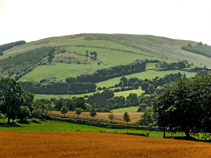
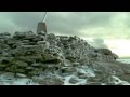
Picture: Highpoint
Unfortunately the most popular access to this hill was from the south, but this is now not possible. A longer approach may be made from the north, starting at A (S92509 93197). Permission has previously been granted by the farmer in the nearby farmhouse, but if there is someone about, please ask. There is parking for one car without blocking gates. (Note: Do not take the track a little nearer the farm as this leads to a field with a bull!) Follow the gently rising track until is starts to peter out around B (S92271 92071), the turn SSW up a grassy slope for about 500m, which will take you to the unmarked high point next to a fence.
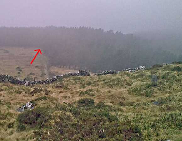
Picture: West of the summit, a way along the ridge.
simon3 on Spinans Hill
by simon3
7 Feb 2010
One way of getting along the ridge between the two Spinans is to follow the route suggested by wicklore through the forest. This route is some 250m long and is easy to use, once you know it it there! From the Spinans Hill SE Top goto C (S92669 91082), a corner of the forest, shown below. Walk approx west along a fence through the trees and emerge right beside the "grey hut" at D (S92409 91095). Linkback: mountainviews.ie/summit/787/comment/4393/
Read Less
Read More
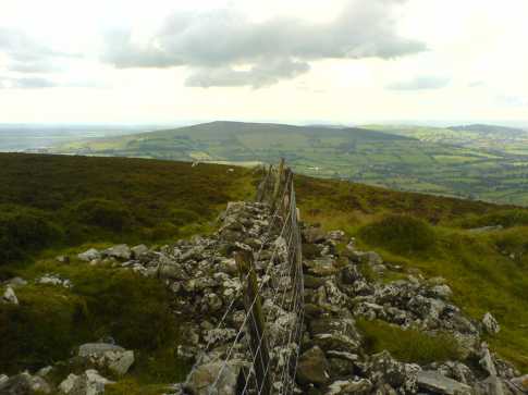
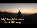
Picture: The view south from the summit of Spinans Hill
csd on Spinans Hill
by csd
22 Jul 2007
Spinans Hill, only 409 metres above sea level. A forest track to take you most of the way to the summit. How hard could it be? I parked at the bottom of the track shown on Sheet 56 at E (S92519 93199) and followed the track south towards the summit. The track peters out as it passes through some grazing fields, but you can pick it up again as it enters the forest. However, any thoughts of it taking me almost all the way to the top with an easy push through some mature conifers towards the end were soon shattered. From the end of the forest track to the open ground near the summit it's a nasty half hour of crouching on all fours, pushing through gorse bushes, and getting covered in pine needles. Do not try approaching through the forest to the south! The summit itself is fairly nondescript: a fence bisecting a collection of rocks that probably once formed a wall. The views over to the western Wicklow Mountains are nice, however, and Blackstairs is visible to the south. Linkback: mountainviews.ie/summit/787/comment/2779/
Read Less
Read More
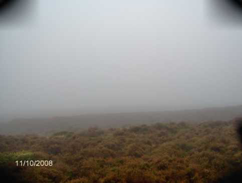
Picture: Navigation required in bad weather
wicklore on Spinans Hill
by wicklore
10 Oct 2008
I climbed Spinian after Spinian SE Top. For those doing the same and following my route they would have arrived at a hut beside a forest. (see Spinian SE Top) To reach this hut directly without climbing SE Top simply park off the road at the gate and track at Moortn Hs (S924 907). Head through the gate and head north on the track. The track reaches a forest. Stay on the track and keep the forest on your right. After 10 minutes of hugging the forest you will reach the aforementioned hut and a fence blocking your path. (ignore an earlier roofed structure on the track with no sides) The forest turns west at the hut, so head west alongside the forest, with the trees on your right. A few minutes brought me to a gate at the end of the forest. I went through the gate and a few minutes north uphill along a track brought me over a fence to the broad summit area. In the poor visibility I continued north until I found the fence at the summit recorded by csd. From the car I would reckon it’s a 25 minute walk to the summit. I could see nothing whatsoever due to the weather but was happy to have found an easy route up. I can empathize with csd and all those who have been forced to crawl and eat pine needles in their quest to find routes up our hills. The compass brought me back through the cloud to the track and I followed the forest down to my car. Linkback: mountainviews.ie/summit/787/comment/3371/
I climbed spinnans hill on 9/6/12. It was pretty easy.When we were going down,we went to the forest. There were mysterious pink ribbons which we thought would lead to another hill. So we followed them. They lead nowhere.So we tried a different way.Then my dad got electrecuted. So we went home.I had a good hill walk. Linkback: mountainviews.ie/summit/787/comment/6855/
Use of MountainViews is governed by conditions and a privacy policy.
Read general information about the site. Opinions in material here are not necessarily endorsed by MountainViews.
Hillwalking is a risk sport. Information in comments, walks, shared GPS tracks or about starting places may
not be accurate for example as regards safety or access permission. You are responsible for your safety and your permission to walk.
See the credits and list definitions.


 Add a Place Comment for Spinans Hill, Cnoc na Spíonán


 Our Facebook page.