This website uses cookies, which are small text files that the website puts on your device to facilitate operation. Cookies help us provide a better service to you. They are used to track general user traffic information and to help the website function properly.
Feature count in area: 38, all in Donegal,
OSI/LPS Maps: 1, 11, 2, 6
Highest Place: Errigal 751m
Starting Places (29) in area Derryveagh Mountains: Aleahan Lough, Altderry Bridge, An Chúirt Hotel, Astelleen Burn Waterfall, Derryreel Lough, Dunlewy Lough E, Dunlewy Lough Viewing Point, Errigal Hostel, Errigal Parking, Glenveagh Bridge, Glenveagh National Park SW, Glenveigh Castle, Keel Lough N, Losset North, Lough Acrobane Farmhouse, Lough Ascardan, Lough Barra Slipway CP, Lough Barra W, Meenagoppoge Burn Bridge, Mín Uí Bhaoil, Muckish Gap Shrine, Muckish North Access Road, Nabrackbaddy Lough, Procklis Lough, River Barra Bridge NE, River Barra Bridge SW, Sand Lough NE, Sruhancrolee Bridge, Stranamarragh Bridge
Summits & other features in area Derryveagh Mountains: Cen: Dooish: Dooish 651.5m, Dooish SW Top 528m, Dooish SE Top 553.9m, Saggartnadooish 506.4m, Saggartnadooish East Top 478.9m Cen: Errigal: Errigal 751m, Mackoght 555m Cen: Glenveagh Upper: Crockfadda 485m, Crockfadda East Top 454m, Crockballaghgeeha 480m, Crockmulroney 430m, Staghall Mountain 486m, Croaghnasaggart 480m, Maumlack 480m Cen: Lough Keel (Meencorwick): Crockglass 489m, Addernymore 416m, Grogan More 457m, Crocknafarragh 517m, Crocknafarragh SE Top 470m Cen: Slieve Snaght: Crockfadda 529m, Crockfadda NE Top 502m, Crocknasharragh 495m, Drumnalifferny Far NE Top 535m, Bingorms 578m, Drumnalifferny Mountain 596m, Drumnalifferny Mountain NE Top 585m, Slieve Snaght 678m N: Aghla: Aghla Beg 563.9m, Aghla Beg South Top 602.3m, Aghla More 581.2m, Ardloughnabrackbaddy 472.5m, Crocknalaragagh 470.6m N: Muckish: Muckish 667.1m, Croaghaderry 222m, Crockawama 238m, Derryreel 232m S: Doochary: Croaghleconnell 266m S: Dungloe: Crovehy 315m
Note: this list of places may include island features such as summits, but not
islands as such.
Errigal, 751mMountain An Earagail A name in Irish,
Place Rating ..
Ir. An Earagail [DUPN], poss. 'oratory’ or ‘secluded spot’ [PDT]. County Highpoint of Donegal in Ulster province, in County Highpoint, Arderin, Vandeleur-Lynam, Irish Highest Hundred Lists, An Earagail is the highest mountain in the Derryveagh Mountains area and the 78th highest in Ireland. An Earagail is the highest point in county Donegal.
Grid Reference B92825 20778,
OS 1:50k mapsheet 1 Place visited by: 1106members, recently by: Timmy.Mullen, Aidan_Ennis, DarrenY, Gavsmi33, Zenny, bowler, ccartwright, Glengirl, farmerjoe1, JohnFinn, chelman7, DeirdreM, GerryCarroll, annette, Combat_Monkey
I visited this place: NO (You need to be a logged-in member for this.)
Longitude: -8.113014, Latitude: 55.034394, Easting: 192825, Northing: 420778,
Prominence: 688m, Isolation: 1.4km, Has trig pillar
ITM: 592775 920768 Bedrock type: Whitish quarztite with pebble beds, (Ards Quartzite Formation) Notes on name: Errigal is well-known for the pinkish glow of its quartzite in the setting sun. It is located on the boundary of four townlands: Beltany Mountain, Dunlewy Near, Procklis, Money More. Despite the name, there are no known remains of an oratory. It may therefore be a metaphorical name for the mountain itself. Alternatively, it may originally be a Brittonic name akin to Welsh argel ‘hiding-place, refuge, secluded spot’. Old Irish has a cognate word airchel, ‘lurking place’, but the -g- in Earagail would be more consistent with the Brittonic form.
Short or GPS IDs, 6 char: Erigal, 10 char: Errigal Linkback: https://mountainviews.ie/summit/76/
Gallery for Errigal (An Earagail) and surrounds
Summary
for Errigal (An Earagail):
Iconic quartzite summit dominating the view in the North West.
Summary created by markmjcampion, Peter Walker, simon3, CaptainVertigo, jackill, Harry Goodman
31 Aug, 2023
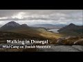
Picture: Errigal from the summit of Mackoght
Errigal is a shapely and visually stunning mountain in the N of Donegal. Its steep, quartzited flanks present a memorable image when viewed from the S. Care is needed on a windy day as the summit section is v exposed. The views to Muckish,Tory, Bloody Foreland, S' Snaght are breath-taking.
SE. Park at Errigal CP (B94291 19734) and follow a wet track on either side of the stream. Just after a large cairn at A (B94151 20379) turn left and follow a now rocky track. It’s well-defined, narrow and steep in places but never dangerous. The E top is the summit. 1hr+
U can easily incl Mackoght to prolong the outing by 1 hr+
N. Park at Prock (B93565 25632). Walk S down the road and at B (B93279 25195) pick up the track due S. At the end of the track head S up the gentle stony shoulder before tackling the steep rocky ridge to the summit. On the way up there is an interesting circular opening on the path through the rocks known as "the keyhole". 2hrs+. Return by way of ascent or if 2 cars are to hand complete a linear walk by descending from the summit down the ridge and then steep stony track to the CP at Errigal CP (B94291 19734). The N ridge can also be reached from the usual ascent route following a track leading N from the Mackoght/Errigal col; this leads under M's W side before wending W to a point where the ridge can be gained just below its obvious steepening.
E lies on the Joey Glover challenge walk, although this hasn’t been staged since 2015.
Notable tracks incl track/4369, track/2223 and track/2773.
Errigal rises majestically above the uncharacteristically calm
Dunlewey Lough beckoning us to climb its snow covered summit the next day Linkback: mountainviews.ie/summit/76/comment/23818/
Read Less
Read More
Sacred view
by mcrtchly
17 Jan 2020
The iconic Church of the Sacred Heart in Dunlewey, County Donegal, nestled at the foot of the county’s quartzite giant, Errigal, frosted white with recent snow and catching the dying rays of the winter sun. Completed in 1877, this wee church built in the Hiberno-Romanesque style, was designed by architect Timothy Hevey and built by James McAdorey from Belfast. Linkback: mountainviews.ie/summit/76/comment/20740/
Read Less
Read More
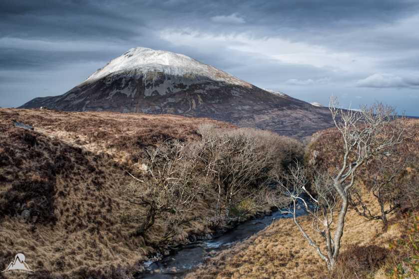
Picture: Errigal from the Devlin Gorge
Last of the winter snow
by mcrtchly
6 Apr 2018
A snow-capped Errigal rises above the Devlin River gorge filled with naked oak trees, as seen from the ascent route to Slieve Snaght. This is a spot we've had our eye on for a few years since discovering it while hillwalking and it appears on our 2015 "Wild Ireland" Derryveagh video. We wanted a winter shot with snow on Donegal's highest mountain, moody grey skies and some light in the foreground to bring out the rich russet tones of the moorland. After several attempts, and during what must surely be the last of this winter's snow, we finally got the shot we were looking for! Linkback: mountainviews.ie/summit/76/comment/19882/
Walk Date: 20 Jun 2016. While on holidays in Donegal we watched for an opportunity to climb Errigal. The weather was generally good but Errigal often has a cloud at the top. Rachel, Dillon(dillonkdy) and I started the walk to the summit of Errigal after 4 PM on a lovely summers afternoon. We did a bit of ziz/zag again to avoid the worst of the boggy parts at the start and soon enough we were on a much drier and stony surface as we started to climb. We had great visibility and there was no problem with working out where to go all the way to the top. Errigal offers fantastic views in all directions, Lough Altan on one side and views over Dunlewy lough and beyond on the other. After a few photos we headed back down to the car park on the R251 where we started. This route took us about 2.5 Hrs climbing a height of 475m and a distance of 4.5 Km up and back.
See Dillon’s (dillonkdy) full story of his County High Point Challenge at https://dillons32chpchallenge.github.io/progress/index.html We also found Kieron Gribbon's High Point Ireland website (www.highpointireland.com) to be a useful source of information for our 32 County High Points challenge. Definitely worth checking out if you're planning to do any of the High Point challenges. Linkback: mountainviews.ie/summit/76/comment/18817/
Use of MountainViews is governed by conditions and a privacy policy.
Read general information about the site. Opinions in material here are not necessarily endorsed by MountainViews.
Hillwalking is a risk sport. Information in comments, walks, shared GPS tracks or about starting places may
not be accurate for example as regards safety or access permission. You are responsible for your safety and your permission to walk.
See the credits and list definitions.


 Add a Place Comment for Errigal, An Earagail


 Our Facebook page.