Cookies.
This website uses cookies, which are small text files that the website puts on your device to facilitate operation. Cookies help us provide a better service to you. They are used to track general user traffic information and to help the website function properly.
Features
Nearby features appear when you click the map.
Declutter tracks on map.
Place Search
Video
X
Pub: by
Partry & Joyce Area , SE: Cornamona Subarea
Feature count in area: 27, by county: Mayo: 15, Galway: 15, of which 3 are in both Galway and Mayo, OSI/LPS Maps: 37, 38, CBE, EW-CON, MSW
Highest Place: Maumtrasna 682m

Starting Places (54) in area Partry & Joyce:
Aasleagh Waterfall CP, An Móinín Mór, Ballydoo Lough, Barrevagh Bridge, Bealanabrack River Tributary, Black Rock, Bohaun, Bracklagh, Buckaun, Bunduvowen, Cammanagh, Carraig Bar, Carrowrevagh Lough, Clonbur, Cummer, Derrassa, Derrinkee Wood, Doon Rock, Failmore River, Finny Church, Fooey River Road, Glendavock, Glenmask, Glennacally Bridge, Glensaulmore Trailhead, Glentraigue, Gowlaunlee Lake, Keelkill North, Killeennimat Burial Ground, Knockaunnabausty (Cnocán na bPáistí), Knocknafaughy SW, L Mamwee, Lecarrow, Leenane, Leenane Hotel, unuseableLeenane R336, Lough Nambrackkeagh, Maum Bridge Road Lower, Maum Bridge Road Mid, Maum Bridge Road Upper, Mount Gable CP, Otter Pool, Owenbrin Bridge, Owenbrin Tributary, Owenduff River, Red Island, RIC Barracks Ruin, Rinavore East, Rinavore SW, Shanafaraghhaun Cross, Sheeffry Pass, Tawnyard Lough, Teevinish West, The Larches Pub

Summits & other features in area Partry & Joyce:
Cen: Finny: Glenbeg East 372m
Cen: Knocknafaughy: Knocknafaughy 254m, Rinavore 426m
Cen: Maumtrasna: Barnahowna 516m, Buckaun East 495m, Glennagleragh Mtn 617m, Knocklaur 518m, Maumtrasna 682m, Maumtrasna North-East Top 572m, Tullymorehill 279m
N: Ballintober Hills: Bohaun 393m, Corveagh 233m, Croaghrimkarra 271m, Keelkil 239m
SE: Cornamona: Mount Gable 417.8m, Bohaun 424m, Knocknagussy 456m
SW: Bunnacunneen: Ben Beg 560m, Bunnacunneen 575m, Bunnacunneen South Top 539m, Bunnacunneen SE Top 479m, Lugnabrick SW Top 494m, Lugnabrick NE Top 494m
W: Devilsmother: Devilsmother 645m, Devilsmother South Top 509m, Devilsmother North Top 595m, Devilsmother Far North Top 601m

Note: this list of places may include island features such as summits, but not islands as such.
Rating graphic.
Mount Gable, 417.8m Hill Binn Shleibhe A name in Irish,
Place Rating ..
(Ir. Binn Shleibhe [OSI], 'peak of the mountain/moorland'). It is
often known as Mount Gable locally.
Benlevy an extra name in English, Galway County in Connacht province, in Carn Lists, Binn Shleibhe is the 864th highest place in Ireland. Binn Shleibhe is the second most southerly summit and also the second most easterly in the Partry & Joyce area.
Grid Reference M05017 54904, OS 1:50k mapsheet 38
Place visited by: 89 members, recently by: oakesave, annem, maryblewitt, Dee68, jkforde, elizauna, abcd, osullivanm, simon3, pdtempan, Tomaslj, Haulie, Ghreallaigh, TommyMc, GoldCircle
I visited this place: NO (You need to be a logged-in member for this.)
Longitude: -9.433285, Latitude: 53.53568, Easting: 105018, Northing: 254905, Prominence: 352m,  Isolation: 4.5km, Has trig pillar
ITM: 504988 754926
Bedrock type: Schists, grits, metavolcanics, mylonitic, (Ben Levy Grit Formation)
Notes on name: Benlevy dominates the narrow neck of land between Lough Mask and Lough Corrib, on which Clonbur and Cong are situated. Walks: for a route to the summit from the SE, see Whilde & Simms, New Irish Walk Guide - West and North, 58-59.
  Short or GPS IDs, 6 char: MntGbl, 10 char: MntGbl

Linkback: https://mountainviews.ie/summit/758/
Gallery for Mount Gable (Binn Shleibhe) and surrounds
Summary for Mount Gable (Binn Shleibhe): Easily accessed hill with broad plateau having great views.
Summary created by simon3 2022-05-28 06:01:44
An obvious place to start is from Ballard, reached on a single track road at Mt Gbl ( Mt Gbl (M072 539)) where there is parking for around 5 cars.. Proceed over the ladder style and follow the track uphill, grassy then boggy and some sections quite steep. The top is a long flattish ridge heading approximately East West with various cairns on minor knolls. The summit towards the western end is on a knoll with a trig pillar.
There are outstanding views in all directions such as towards the Maamturks to the west, Maumtrasna to the norrth and the two major lakes of the area: Lough Corrib to the south and Lough Mask, both of which have numerous islands. A particularly interesting view is of Lough Coolin which you can overlook from the NE of the ridge.
Total time up an down around 1h30
Linkback: mountainviews.ie/summit/758/comment/5517/
Member Comments for Mount Gable (Binn Shleibhe)
Comment create / edit display placeholder

            MountainViews.ie picture about Mount Gable (<em>Binn Shleibhe</em>)
Sunset on the peak area - November 30th, 2019
by magnumpig 30 Nov 2019
Picture taken in direction of Maam Cross and Lackavrea. As others have noted, spectacular views for little effort. The old bog road to the summit from the car park is very cute too. Linkback: mountainviews.ie/summit/758/comment/20687/
Read Less
Read More

            MountainViews.ie picture about Mount Gable (<em>Binn Shleibhe</em>)
Picture: Benlevy in full splendour.
Benlevy (Mount Gable) on 24.02.2012
by FilHil 5 Apr 2012
As mentioned by Bruno follow a single track road leading to Ballard. New-ish blue-on-white signs will direct you to a small parking area ( Mt Gbl ( Mt Gbl (M072 539))) good for about 4 cars. Proceed over the ladder style and follow the track uphill, grassy then boggy and some sections quite steep. Old turf fields are in evidence near the top, reason that the track exists at all.

I wanted to share the picture of Benlevy, taken from the track up neighbouring Teeranea hill leading to Bohaun. Linkback: mountainviews.ie/summit/758/comment/6752/
Read Less
Read More

            MountainViews.ie picture about Mount Gable (<em>Binn Shleibhe</em>)
Picture: Lough Coolin
bruno on Mount Gable
by bruno 31 Aug 2009
Mount Gable (Ben Levy on OSI Map)

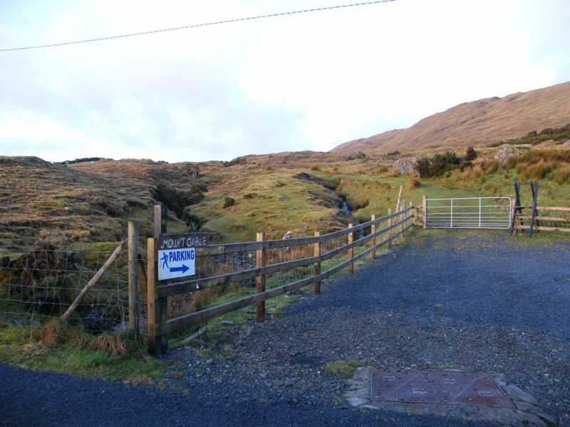
Did this walk a few weeks ago with NWM Hillwalkers. From Clonbur follow the R345 road signposted for Corr na Mona. Just after community centre take the right turn and continue uphill towards Mount Gable. When you reach a minor road junction turn left for Ballard until you reach a ladder stile beside a gate on the right.

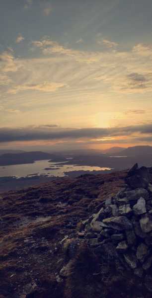
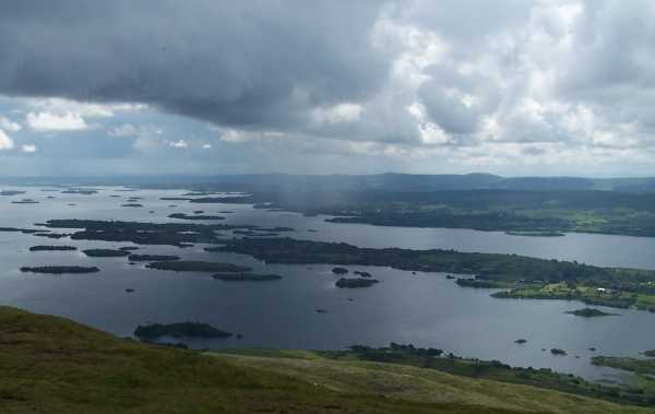
Follow the zig-zag track uphill until you reach the crest of Mount Gable bringing both Lough Corrib and Lough Mask into view. Swing left and walk along the crest passing a cairn. Keep on past cairn until you reach the concrete trig point at 416m (1,370ft) on the true summit.

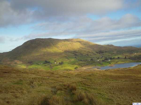
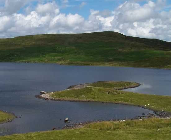
Leave the trig point and head for nearby cairn overlooking Lough Coolin. Aim for the shore of Lough Coolin, but stay on the grassy slopes avoiding rocky outcrops on the way down. A track on the lower slopes leads to the shore of Lough Coolin. Head for deserted village on lake shore.

Follow rugged path around the shore of Lough Coolin. A good track continues downstream, drifting away from the river beside a conifer planation. Beyond a gate, a narrow tarmac road runs downhill, passing a few houses. The road is very quiet and is actually grass-grown in places. When you reach a junction at the bottom, turn right and continue as far as stile form where you started. Linkback: mountainviews.ie/summit/758/comment/3958/
Read Less
Read More

            MountainViews.ie picture about Mount Gable (<em>Binn Shleibhe</em>)
Picture: A shower approaches over Lough Corrib as seen from Benlevy
bruno on Mount Gable
by bruno 31 Aug 2009
Tremendous views of Lough Mask and Lough Corrib- this is an ideal walk for beginners to hillwalking as it gives excellent panoramic views of lakes and surrounding Maamturk, Maamtrasna and Connemara mountains without too much effort. Linkback: mountainviews.ie/summit/758/comment/4065/
Read Less
Read More

            MountainViews.ie picture about Mount Gable (<em>Binn Shleibhe</em>)
Picture: Benlevy start area facilities.
A walker friendly hill.
by paddyhillsbagger 8 Jan 2013
Congratulations to Galway Co Co or whosoever provided the small carpark. Mount Gable walking signs and style which greet you upon arrival at Mt Gbl (M072 539), as mentioned by bruno and Filhill. Lovely to find a welcome to the hills! Only downside is that it's a long trek across the boggy summit plateau to the trig point so keen baggers may wish to find a shorter route from the West. Linkback: mountainviews.ie/summit/758/comment/14900/
Read Less
Read More
EDIT Point of Interest
text
Videos


Recent Contributions
x
Conditions and Info
Use of MountainViews is governed by conditions and a privacy policy.
Read general information about the site.
Opinions in material here are not necessarily endorsed by MountainViews.
Hillwalking is a risk sport. Information in comments, walks, shared GPS tracks or about starting places may not be accurate for example as regards safety or access permission. You are responsible for your safety and your permission to walk.
See the credits and list definitions.

OSi logo
OSNI/LPS logo
Open Street Map
(Various variations used.)
British summit data courtesy:
Database of British & Irish Hills