This website uses cookies, which are small text files that the website puts on your device to facilitate operation. Cookies help us provide a better service to you. They are used to track general user traffic information and to help the website function properly.
Feature count in area: 11, all in Cork,
OSI/LPS Maps: 79, 80
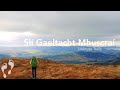
Highest Place: Musheramore 642.7m
Starting Places (8) in area Boggeragh Mountains: Butter Road, Duhallow Way, Derry Wood, Glannaharee East Woods S, Laharan Woods N, Millstreet Country Park, Mount Hillary Wood N, Mount Hillary Wood W, St John's Well
Summits & other features in area Boggeragh Mountains: Cen: Seefin: Knockcraugh 434m, Seefin 491m, Seefin East Top 491m N: Banteer: Mount Hillary 391m, Tooreen 322m NE: Bweeng: Bweeng Little 414m, Bweengduff 416m S: Macroom Hills: Burren 380m, Knockagreenan 263m W: Musheramore: Musherabeg 498.8m, Musheramore 642.7m
Note: this list of places may include island features such as summits, but not
islands as such.
Bweengduff, 416mHill
Place Rating ..
, Cork County in Munster province, in Carn Lists, Bweengduff is the 872nd highest place in Ireland. Bweengduff is the most easterly summit in the Boggeragh Mountains area.
Grid Reference W46872 90378,
OS 1:50k mapsheet 80 Place visited by: 45members, recently by: dregish, daitho9, Petecal423, DeirdreM, Baker_beauty, Leatra, Pepe, Colin Murphy, oreills8, learykid, maryblewitt, John.geary, chelman7, jgdarcy, tommccarthy
I visited this place: NO (You need to be a logged-in member for this.)
Longitude: -8.775381, Latitude: 52.063316, Easting: 146872, Northing: 90378,
Prominence: 90m, Isolation: 0.6km, Has trig pillar
ITM: 546833 590435 Bedrock type: Purple mudstone and sandstone, (Ballytrasna Formation) Notes on name: Whilst the origin of this unusual name, along with Bweengduff, is unclear, they are almost certainly related to the nearby settlement of Bweeng (Ir. Na Boinn) and the townlands of Beennamweel East and West. One possibility is that Boinn is a corruption of Ir. muing, ‘rushy area’, and this explanation would fit well with its application to an upland areas of moderate height in Bweeng Little and Bweengduff.
Short or GPS IDs, 6 char: Bwngdf, 10 char: Bweengduff Linkback: https://mountainviews.ie/summit/757/
Gallery for Bweengduff and surrounds
Summary
for Bweengduff :
A good forest road to access this summit
Summary created by Colin Murphy, jackill
2023-03-17 14:24:17
Picture: The final approach to the mast-covered summit
Park at a forest entrance GlHareeE WdN (W46444 88741), room for 5 cars. Follow the track into the forest , along the Duhallow way, taking the second left, then the first right, then second left then first right up to the buildings and masts. Follow the track around the back of the building to the trig pillar
This isn't a particularly interesting hill, although after a prolonged rainy period, I did see multiple gushing streams on my walk, some of them having flooded sections of the forest track. There is also now a relatively new sign next to the trig pillar saying that the track is part of The Shiddy Way, although I can find no information about this online, so have no idea where it starts and ends. Linkback: mountainviews.ie/summit/757/comment/23860/
Read Less
Read More
Picture: The summit trig pillar with Bweeng Little behind
jackill on Bweengduff
by jackill
26 Aug 2009
Tis an awful affliction bagging hills. Worse again is bagging hills under 500 meters because you stupidly tell yourself , "ah sure I'll get 4 or 5" and end up crippled by distance and drowned by bogwater. Such is the case with trying the Bweengs and Mount Hillary on the same day.
Anyway Bweengduff is reached from the road at GlHareeE WdN (W46444 88741) by following the Duhallow way (and don't take shortcuts unless you like swimming!) and hanging a left and then a right to the most mast adorned summit in Ireland. Linkback: mountainviews.ie/summit/757/comment/4051/
Read Less
Read More
Picture: A picture paints a thousand words
Giovanni Agnelli would not be proud!
by eamonoc
17 May 2015
I started my ascent of Bweengduff and Bweeng little from A (W46004 91412), was able to drive to this point elevation
of 254mts, just followed good track all the way to Summit area. Was more than dissapointed with what I discovered
behind one of the mast enclosures. A fiat car that was maybe stolen or not! and driven up to Bweengduff and dumped
what a sad sight, after the Bullets on Newtown Hill, the open dump on Coolnahau Hill and now the scrapyard of Bweengduff
I wonder what next. Some sad people out there! Linkback: mountainviews.ie/summit/757/comment/17988/
Read Less
Read More
Enjoyable Walk !
by damomac
24 Jun 2016
Nice handy walk on good roadway which has recently been upgraded to facilitate installation of more wind turbines. Park at forest entrance and it's approx 3km to the telecommunication masts. For a more challenging walk, loop around Bweeng Little and continue on down to Laharn Cross (6km from car). Do it on a sunday evening and you might take in some irish dancing (http://irdduhallow.com/tourism-and-culture-north-cork-kerry/culture/laharn-cross-dancing/).
Turn right at the cross roads and after 200 meters take the next gravel road on right and this will take you back to the masts. Parts of this are a good workout but the path surface is very good. Continue past the masts and back to the car for a 13.3km walk which can take 2 hrs 45 mins. Good mobile phone coverage throughout all the walk.
my first hill was an easy one, actually cycled up to it before i realised it was high point. a good starter, hard core road all the way to the top. lots of masts at the top but a short trip across to bweeng little will give you better scenery. Linkback: mountainviews.ie/summit/757/comment/15091/
Use of MountainViews is governed by conditions and a privacy policy.
Read general information about the site. Opinions in material here are not necessarily endorsed by MountainViews.
Hillwalking is a risk sport. Information in comments, walks, shared GPS tracks or about starting places may
not be accurate for example as regards safety or access permission. You are responsible for your safety and your permission to walk.
See the credits and list definitions.


 Add a Place Comment for Bweengduff


 Our Facebook page.