Cookies.
This website uses cookies, which are small text files that the website puts on your device to facilitate operation. Cookies help us provide a better service to you. They are used to track general user traffic information and to help the website function properly.
Features
Nearby features appear when you click the map.
Declutter tracks on map.
Place Search
Video
X
Pub: by
Derryveagh Mountains Area , Cen: Lough Keel (Meencorwick) Subarea
Feature count in area: 38, all in Donegal, OSI/LPS Maps: 1, 11, 2, 6
Highest Place: Errigal 751m

Starting Places (29) in area Derryveagh Mountains:
Aleahan Lough, Altderry Bridge, An Chúirt Hotel, Astelleen Burn Waterfall, Derryreel Lough, Dunlewy Lough E, Dunlewy Lough Viewing Point, Errigal Hostel, Errigal Parking, Glenveagh Bridge, Glenveagh National Park SW, Glenveigh Castle, Keel Lough N, Losset North, Lough Acrobane Farmhouse, Lough Ascardan, Lough Barra Slipway CP, Lough Barra W, Meenagoppoge Burn Bridge, Mín Uí Bhaoil, Muckish Gap Shrine, Muckish North Access Road, Nabrackbaddy Lough, Procklis Lough, River Barra Bridge NE, River Barra Bridge SW, Sand Lough NE, Sruhancrolee Bridge, Stranamarragh Bridge

Summits & other features in area Derryveagh Mountains:
Cen: Dooish: Dooish 651.5m, Dooish SW Top 528m, Dooish SE Top 553.9m, Saggartnadooish 506.4m, Saggartnadooish East Top 478.9m
Cen: Errigal: Errigal 751m, Mackoght 555m
Cen: Glenveagh Upper: Crockfadda 485m, Crockfadda East Top 454m, Crockballaghgeeha 480m, Crockmulroney 430m, Staghall Mountain 486m, Croaghnasaggart 480m, Maumlack 480m
Cen: Lough Keel (Meencorwick): Crockglass 489m, Addernymore 416m, Grogan More 457m, Crocknafarragh 517m, Crocknafarragh SE Top 470m
Cen: Slieve Snaght: Crockfadda 529m, Crockfadda NE Top 502m, Crocknasharragh 495m, Drumnalifferny Far NE Top 535m, Bingorms 578m, Drumnalifferny Mountain 596m, Drumnalifferny Mountain NE Top 585m, Slieve Snaght 678m
N: Aghla: Aghla Beg 563.9m, Aghla Beg South Top 602.3m, Aghla More 581.2m, Ardloughnabrackbaddy 472.5m, Crocknalaragagh 470.6m
N: Muckish: Muckish 667.1m, Croaghaderry 222m, Crockawama 238m, Derryreel 232m
S: Doochary: Croaghleconnell 266m
S: Dungloe: Crovehy 315m

Note: this list of places may include island features such as summits, but not islands as such.
Rating graphic.
Addernymore, 416m Hill An Eadarna Mhór A name in Irish,
Place Rating ..
(Ir. An Eadarna Mhór [OSI], 'the big [obscure element]'), Donegal County in Ulster province, in Carn Lists, An Eadarna Mhór is the 870th highest place in Ireland.
Grid Reference B88911 15185, OS 1:50k mapsheet 1
Place visited by: 25 members, recently by: dodser, madfrankie, Colin Murphy, Lucky1, eamonoc, Ulsterpooka, Fergalh, finkey86, shaunkelly, melohara, markmjcampion, KevinRoche, kenmoore, kernowclimber, mcrtchly
I visited this place: NO (You need to be a logged-in member for this.)
Longitude: -8.173992, Latitude: 54.984029, Easting: 188911, Northing: 415185, Prominence: 51m,  Isolation: 1.4km
ITM: 588863 915170
Bedrock type: Coarse biotite granite & granodiorite, (Main Donegal Granite)

  Short or GPS IDs, 6 char: Adrnym, 10 char: Adernymore

Linkback: https://mountainviews.ie/summit/755/
Gallery for Addernymore (An Eadarna Mhór) and surrounds
Summary for Addernymore (An Eadarna Mhór): All a bit of a slog!
Summary created by Harry Goodman 2011-11-09 17:34:33
            MountainViews.ie picture about Addernymore (<em>An Eadarna Mhór</em>)
Picture: Addernymore from a farm track looking NE.
To get to the starting point for a walk up and down this hill take a minor road off the N56, just south of Crolly at A (B833 197) and follow it SSE for about 6k to a turn off to the right at B (B862 145). Go right for about 100m to L Ascrdn (B86228 14313) where a rough farm track goes off to the left (E). This is the start of the walk. Park carefully to avoid any obstruction.Follow this track for about 750m to C (B86897 14085). Leave the track at this point and go down right to a wooden farm bridge D (B86920 14055) and cross over the Owencrovarra River. From here go NE up the wide heather covered slope, past some rocky up crops, for about 2.5k to the top. The high point lies on a broad heathery moorland and is marked by a small cairn of stones E (B88911 15185) and close to a small pond. Return by way of ascent. A more preferable way to climb this hill is to include it as the final top in a round of 5 starting with Grogan More, then Crocknafarragh, Crocknafarragh SE Top and Crockglass. On its own it has little to commend it as a hillwalking experience.
Linkback: mountainviews.ie/summit/755/comment/5514/
Member Comments for Addernymore (An Eadarna Mhór)
Comment create / edit display placeholder

            MountainViews.ie picture about Addernymore (<em>An Eadarna Mhór</em>)
Picture: Summit cairn on Addernymore with Errigal peeping over the horizon
Not much going for it!
by Harry Goodman 30 Nov 2020
I climbed or more correctly traversed Addernymore from NE to SW on 10 Aug as the final hill in a round of five tops that I had not previously visited. My approach was from Crockglass summit F (B89230 16629) by heading down to Pt 352 
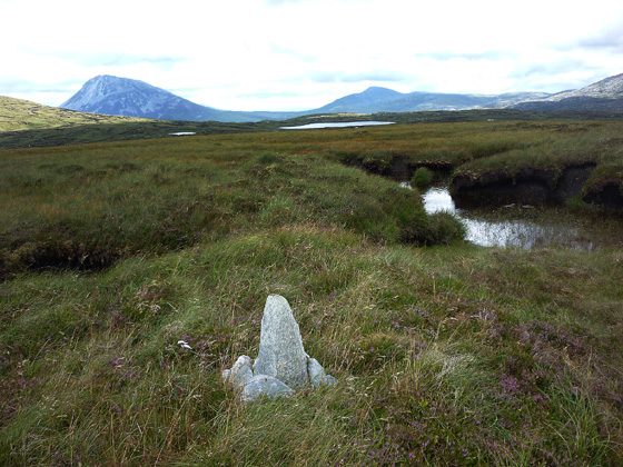
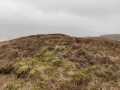
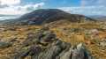
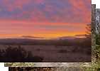
G (B89200 16000) over a very wet and sticky patch of bog requiring much clambering in and out, up and down, numerous peat hags. (For previous part of route see Crocknafarragh SE Top.) After this boggy area was crossed the slope up the hill was much more pleasant and gentle to the top. The top of the hill is marked by a small cairn and is close to a small pond. It is on a broad, flat, heathery moorland (see photo). On the way down SW there was much heather and some rock but the going was relatively easy. My only concern was that my choosen reference point was at a stream that had to be crossedI may be impassable due to the heavy rain of recent date. I need not have worried as it led me down, as I hoped it might, to a wooden footbridge not marked on my map D (B86920 14055) to link up with a rough farm track C (B86897 14085) which I then followed out WNW to to a junction with an unsurfaced road L Ascrdn (B86228 14313). From here I turned right and walked the short distance to a minor road where a right turn and some 6k of road walking brought me back to my starting point for the round MínBhil (B83874 18575), at a church car park and from where I had ascended my first top of the day Grogan More. For anyone with access to a second car or a pick up the road walking can easily be eliminated by parking at a convenient point near L Ascrdn (B86228 14313). This would also be the place to park for a walk up and back down Addernymore although it would be a long slog with little satisfaction. The total distace covered in my circular walk was 18.35k including the 6k road walk at the end. The walk out to the top and back would be some 8k. (For details of the first part of my overall route see Comments for Grogan More.) Linkback: mountainviews.ie/summit/755/comment/6007/
Read Less
Read More

            MountainViews.ie picture about Addernymore (<em>An Eadarna Mhór</em>)
Picture: Lough Ascardan to the west of the hill.
Best to look from it, rather than at it...
by Colin Murphy 8 May 2023
One giant sod of turf, marked by horrible peat hags to the north and a boggy valley to the south! Having said that, descending to the west brought us to a minor road with stunning views over Loughs Ascardan and Keel, which was the hill's only redeeming feature! Linkback: mountainviews.ie/summit/755/comment/23946/
Read Less
Read More
EDIT Point of Interest
text
Videos


Recent Contributions
x
Conditions and Info
Use of MountainViews is governed by conditions and a privacy policy.
Read general information about the site.
Opinions in material here are not necessarily endorsed by MountainViews.
Hillwalking is a risk sport. Information in comments, walks, shared GPS tracks or about starting places may not be accurate for example as regards safety or access permission. You are responsible for your safety and your permission to walk.
See the credits and list definitions.

OSi logo
OSNI/LPS logo
Open Street Map
(Various variations used.)
British summit data courtesy:
Database of British & Irish Hills