Cookies.
This website uses cookies, which are small text files that the website puts on your device to facilitate operation. Cookies help us provide a better service to you. They are used to track general user traffic information and to help the website function properly.
Features
Nearby features appear when you click the map.
Declutter tracks on map.
Place Search
Video
X
Pub: by
Inishowen Area , NW: Urris Subarea
Feature count in area: 27, by county: Donegal: 27, Derry: 1, of which 1 is in both Derry and Donegal, OSI/LPS Maps: 2, 3, 4, 6, 7
Highest Place: Slieve Snaght 614.6m

Starting Places (43) in area Inishowen:
Adderville Upper, Barnes Bend, Bunacrick, Butlers Bridge, Carnaghan Presbyterian Church, Castruse Upper, Craignacoolagh, Craignamuck, Croaghglengad West, Crockavishane South, Diarmuid and Gráinne's Bed, Doherty's Dún, Dunree Bay Carpark, EEl Hole, Effishmore Upper, Evishbreedy Bridge, Five Fingers Strand, Gap of Mamore Grotto, Gap of Mamore Road, Gap of Mamore Viewpoint, Glack, Glasmullan, Golan Bridge Track, Goorey Hill, Grania's Gap, Gransha Árd, Green Hill, Leamacrossan Hill East, Lisfannon Beach, Lough Shivnagh, Lough Turk North, Magilligan Point View, Meenabroagh, Meenyollan River, Moor House, Mullagh, Pincher's Corner, Rashenny, Roosky Upper, Rowantree Hill, St Michael's Church, Stroove Beach, Tullagh Beach

Summits & other features in area Inishowen:
Cen: Slieve Snaght: Damph 420m, Slieve Main 514m, Slieve Snaght 614.6m
N: Malin: Croaghglengad 259m, Crockalough 282m, Soldiers hill 174m
NE: North East Inishowen: Crockavishane 322m, Crocknasmug 327.5m, Grinlieve 371m
NW: Urris: Binnion 250m, Bulbin 494m, Coolcross Hill 291m, Croaghcarragh 400m, Crockmain 460m, Dunaff Hill 230m, Mamore Hill 423m, Raghtin More 502m, Slievekeeragh 389m, Urris Hills 417m
S: Iskaheen: Crockglass 397m, Eskaheen Mountain 418m, Greenan Mountain 241m, Holywell Hill 260m, Inch Top 222m, Leamacrossan Hill 392m, Mouldy Hill 312m, Scalp Mountain 484m

Note: this list of places may include island features such as summits, but not islands as such.
Rating graphic.
Mamore Hill, 423m Hill Cnoc an Mháim Mhóir A name in Irish,
Place Rating ..
, Donegal County in Ulster province, in Carn Lists, Mamore Hill is the 841st highest place in Ireland.
Grid Reference C32426 43591, OS 1:50k mapsheet 3
Place visited by: 72 members, recently by: johncusack, Meenat, padstowe, eamonoc, Kilcoobin, Cathal-Kelly, tinycoyle, LorraineG60, Lauranna, Fergalh, MichaelG55, marcellawalking, gerwalking, jmcunningham, whoRya
I visited this place: NO (You need to be a logged-in member for this.)
Longitude: -7.491084, Latitude: 55.238243, Easting: 232426, Northing: 443591, Prominence: 118m,  Isolation: 1.5km
ITM: 632368 943570
Bedrock type: Whitish quartzite with pebble beds, (Slieve Tooey Quartzite Formation)

  Short or GPS IDs, 6 char: MmrHl, 10 char: Mamore Hil

Linkback: https://mountainviews.ie/summit/727/
Gallery for Mamore Hill (Cnoc an Mháim Mhóir) and surrounds
Summary for Mamore Hill (Cnoc an Mháim Mhóir): Fine, rocky summit with outstanding views.
Summary created by Colin Murphy 2022-04-18 13:19:16
            MountainViews.ie picture about Mamore Hill (<em>Cnoc an Mháim Mhóir</em>)
Picture: The double-cairned summit.
There is parking for about 3 cars at A (C320 428). There is also a similar parking space about 100m south. Cross the road and then a short section of heather before ascending along the ridge that runs to the NE. The terrain is a mixture of short heather and large rocky outcrops and is firm underfoot. A narrow trail runs most of the way up the hill. The ascent is a relatively easy gradient. After about 1km you will reach the first of two apparent 'summits', each marked by a substantial cairn, and separated by about 100m. The more southerly of these (the one you reach first) measures a couple of metres higher than the other, although at both points the other cairn looks taller. 40 minutes from car to cairn.
Linkback: mountainviews.ie/summit/727/comment/5486/
Member Comments for Mamore Hill (Cnoc an Mháim Mhóir)
Comment create / edit display placeholder

three5four0 on Mamore Hill
by three5four0 28 Jul 2008
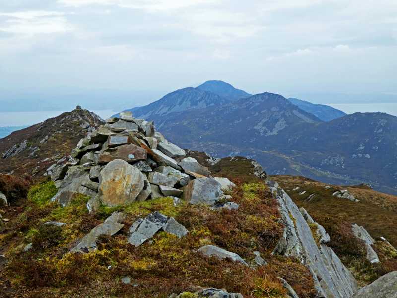
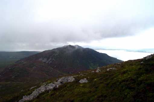
After being rained off on a stormy day several weeks ago, we returned to complete the Raghtin More - Urrishills ridge, this time starting from where we left off, at the car park above Mamore bridge. The track up to the col was of the usual soft type, but quite good despite that. There was however an unusual amount of clegs, forcing the better half to quickly change from her shorts to trekking pants in a blink of an eye, while i tried to kill as many of them as possible. Climbing up a small sharp slope before a gentler rise to the summit of Mamore Hill, the last of the morning mist disappeared into a blue sky and the promised good day by the weather men arrived. We continued with the descent down to the Gap of Mamore and followed the old quarry track (the one on the north side of the Gap and not marked on the map) before ascending up through heather and then a faint path to the first top for a spot of lunch. There is a small path following the ridge over Croaghcarragh to Urris Hills and this tended to go straight up the sharp slopes on the far sides of the small descents on this ridge walk. But if you looked carefully, there is in some places, a more contouring path which rises to the right of these small cols in an arc back up onto the ridge.

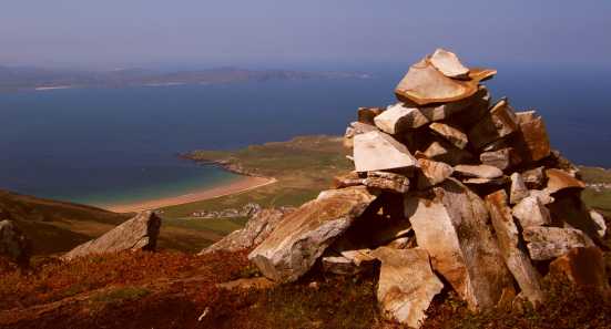
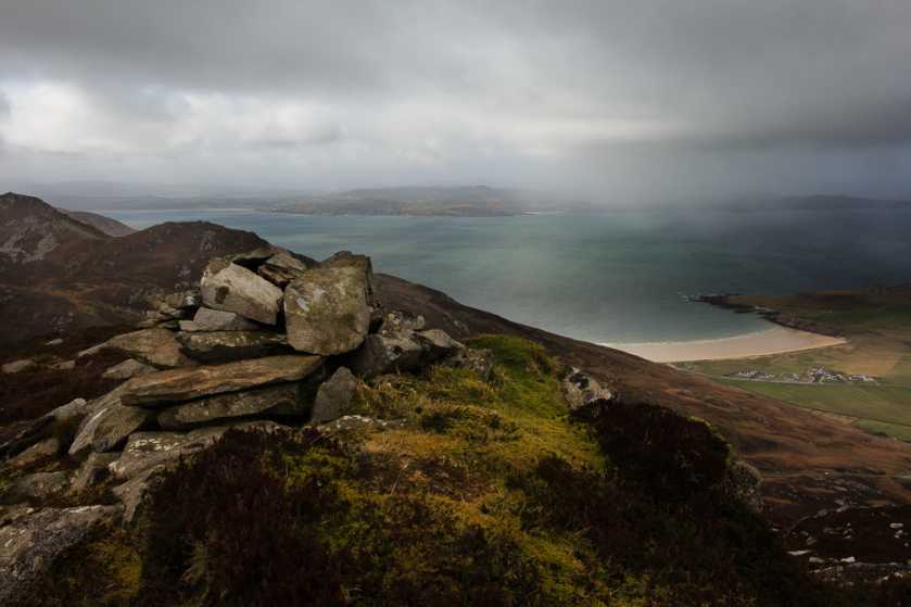
The good weather gave far ranging views all around, in complete contrast to our previous visit, the summit of the Urris Hills gave one surprise, after the earlier clegs, we now encountered Ladybirds which was a much better experience, despite finding them everywhere on our clothes and rucksacks. We descended to Lough Fad (a wonderfully dark lochan with a rocky ridge behind) and followed the river downhill, till we met the the tracks to Lenankeel, then the road back to Mamore Bridge.

Whilst supping a pint in the Rusty Nail, the barman enquired were we had been walking. After we had told him, he said there was a path right to the summit of Raghtin More, from in front of the pub and that is the way some in the pub would climb the hill. Might be of interest, given that the eastern slopes are of the soft variety or when the river cannot be forded. Linkback: mountainviews.ie/summit/727/comment/3249/
Read Less
Read More

            MountainViews.ie picture about Mamore Hill (<em>Cnoc an Mháim Mhóir</em>)
padodes on Mamore Hill
by padodes 5 Jul 2007
Starting out from the 'Waterfall Carpark' at But Br (C359 469) and climbing to the rather bland tops of Raghtin Beg and Raghtin More, I dropped down to Crockmain. The photo, taken from there, gives the view that one has then of Mamore Hill further south, beyond Mamore Gap. On a rather 'atmospheric' day, with the moisture-laden winds from the Atlantic forming clouds before my eyes and the threatening rumble of thunder every few minutes, I decided to give Mamore a miss this time, but it's definitely a little jewel, with the promise of good views and a narrow ridge further south. To return to my point of departure, I had to be content with crossing over to Slievekeeragh to the east and following it northwards with a fine view of the narrow defile of Butler's Glen to the left, before its stream cascades down into the beautiful little park below. Linkback: mountainviews.ie/summit/727/comment/2763/
Read Less
Read More

            MountainViews.ie picture about Mamore Hill (<em>Cnoc an Mháim Mhóir</em>)
Picture: looking to Lehan Bay from summit
gerrym on Mamore Hill
by gerrym 31 May 2008
I had missed Mamore Hill on my last visit along the length of these hills and was determined to put this wrong to right. I came from Butlers Glen to the N, taking in Raghtin Beg & More and Crockmain, before dropping down steeply to bask at the foot of this hill. Mamore is an exciting looking prospect on the descent from Crockmain and i suppose it did not disappoint.
There is a linking area of higher ground between the two hills and this should be followed to the base of a steep climb alongside areas of scree. There has been traffic on this straight upwards section and some accompanying erosion. On reaching the top there is a more gentle winding track thorugh the heather to the top proper and a small cairn. The views from here are beautiful - looking back it is hard to distinguish where Crockmain ends and Raghtin More begins as the ground rises steeply from sea level to over 500m. The little beach at Lehan Bay had specks of people on its colourful strand far below and there was plenty of other high and low sights to capture the minds eye. There is another small cairn ahead and a great descent above the road climbing through Mamore Gap. This is on an ever narrowing line which has bare rock jutting up before dropping to the road at the Gap itself.
Choices, choices - continue on or not. Unfortunately it was not, partly to avoid a long road walk back to the car at Bulters Glen. Walking down the road on the E side brings a farm track on the left which heads up the valley and down to Butlers Glen in a much more acceptable way than the road. Linkback: mountainviews.ie/summit/727/comment/3134/
Read Less
Read More

            MountainViews.ie picture about Mamore Hill (<em>Cnoc an Mháim Mhóir</em>)
Picture: Cloud closing in but still great views.
Part Of A Brilliant Ridge Of Hills
by Aidy 28 Mar 2017
Tackled after walking Croaghcarragh and Urris Hills on the other side of Mamore Gap, and before continuing on as far as Crockmain, this was one the best days I've spent in the hills. Even a bit of a deterioration in the weather couldn't spoil the splendour of the views from this ridge. Linkback: mountainviews.ie/summit/727/comment/18869/
Read Less
Read More
EDIT Point of Interest
text
Videos


Users Online
Djouce, Dee68, GerryCarroll, MickM45, Hjonna
Guests online: 267
Recent Contributions
x
Conditions and Info
Use of MountainViews is governed by conditions and a privacy policy.
Read general information about the site.
Opinions in material here are not necessarily endorsed by MountainViews.
Hillwalking is a risk sport. Information in comments, walks, shared GPS tracks or about starting places may not be accurate for example as regards safety or access permission. You are responsible for your safety and your permission to walk.
See the credits and list definitions.

OSi logo
OSNI/LPS logo
Open Street Map
(Various variations used.)
British summit data courtesy:
Database of British & Irish Hills