This website uses cookies, which are small text files that the website puts on your device to facilitate operation. Cookies help us provide a better service to you. They are used to track general user traffic information and to help the website function properly.
Bluestack MountainsArea, SW: Eany Beg Hills
Subarea
Feature count in area: 45, all in Donegal,
OSI/LPS Maps: 11, 6
Highest Place: Croaghgorm 674m
Starting Places (22) in area Bluestack Mountains: An Leathchruach, Barnsmore Gap, Bensons Hill, Caldragh CP, Clogher South peak, Cruach Mhín an Neanta, Doobin, Eanybeg Water Bridge, Edergole Farm, Gaugin Mountain, Glennacree CP, Hillhead, Lough Finn West, Lough Magrath Beg NE, Lough Muck North, Meenaguse Lough, Sand Lough Forest Picnic Area, Scoil Náisúnta an Choimín, Sheskinlubanagh, Sruell Gap Farm, Sruell River Road, St Columbkilles Well and Altar
Summits & other features in area Bluestack Mountains: Cen: Reelan Hills: Altnapaste 364m, Gaugin Mountain 565m, Lacroagh 403m, Boultypatrick 429m, Croveenananta 476m, Croaghubbrid 416m, Croaghugagh 410m N: Fintown Hills: Aghla Mountain South Top 589m, Aghla Mountain 593m, Scraigs 426m, Croaghleheen 385m NW: Glenties: Cloghercor South 301m, Derkbeg Hill 332m, Drumnalough Hill 282m S: Belshade: Croaghgorm 674m, Croaghgorm South-West Top 597m, Croaghgorm East Top 594m, Ardnageer 642m, Ardnageer SW Top 626m, Banagher Hill 392m, Croaghbane 641m, Croaghgorm Far South-West Top 561m, Cronamuck 444m, Croaghbarnes 498.8m, Glascarns Hill 578.3m, Meenanea 435m SE: Barnesmore: Brown's Hill 496.4m, Cloghervaddy 402m, Croaghagranagh 440m, Croaghanirwore 546.1m, Croaghbrack 401m, Croaghconnellagh 523m, Croaghnageer 569.1m, Croaghnageer East Top 543.5m, Croaghnageer North-East Top 521m, Croaghonagh 451m SW: Eany Beg Hills: Binbane 453m, Binbane NE Top 439m, Lavagh Beg 650m, Lavagh More 671m, Binnasruell 505m, Carnaween 521m, Cloghmeen Hill 429m, Silver Hill 600m, Cullaghacro 476m
Note: this list of places may include island features such as summits, but not
islands as such.
Binbane NE Top, 439mHill An Bhinn Bhán (mullach thoir thuaidh) A name in Irish,
Place Rating ..
For origin of name, see An Bhinn Bhán / Binbane., Donegal County in Ulster province, in Carn Lists, An Bhinn Bhán (mullach thoir thuaidh) is the 777th highest place in Ireland.
Grid Reference G84371 87345,
OS 1:50k mapsheet 11 Place visited by: 29members, recently by: Colin Murphy, BleckCra, gdg, leader1, eamonoc, IainT, madfrankie, melohara, johncromie, Aidy, JimMc, hgboyle, markmjcampion, simoburn, Fergalh
I visited this place: NO (You need to be a logged-in member for this.)
Longitude: -8.243394, Latitude: 54.733842, Easting: 184371, Northing: 387345,
Prominence: 38m, Isolation: 0.7km ITM: 584324 887337 Bedrock type: Pale quartzite, pebble beds, rare schist, (Gaugin Quartzite Formation) Notes on name: Luaghnabrogue is a nearby townland.
Short or GPS IDs, 6 char: BnbnNE, 10 char: BnbnNETp Linkback: https://mountainviews.ie/summit/663/
Gallery for Binbane NE Top (An Bhinn Bhán (mullach thoir thuaidh)) and surrounds
Summary
for Binbane NE Top (An Bhinn Bhán (mullach thoir thuaidh)):
Simple bag from its neighbouring top.
Summary created by Colin Murphy
2024-04-29 11:22:37
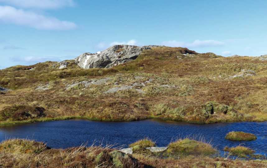
Picture: This rocky outcrop marks highpoint
See Binbane summary for initial approach. From Binbane this top is a mere 600m. Head directly east, dropping down to about 400m elevation at the col, which is spotted with a few small pools. From the col the climb is just 40m. The highpoint is on a rocky outcrop with a small pile of stones on top. About fifteen minutes from one top to the next.
This top is part of the ridge from the brilliant viewing point of Binbane towards the bulk of the Bluestacks. As of 2007 there is absolutely no path along this ridge. The going is wet and rough underfoot.
Access can be had from the road at A (G8408 8893) over rough ground beside a forest.
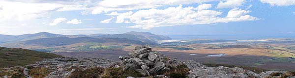
Like Binbane the top has excellent views. The photo shows the beach at Loughros with the complex peak of Slievetooey above it on and the summit of Common Mountain the peak shown to the left skyline. Linkback: mountainviews.ie/summit/663/comment/2851/
Read Less
Read More
Slow going but worth it!
by Geo
19 Sep 2013
Started this round of the two Binbane's and their neighbour Cloghmeen Hill by parking at approx B (G825 884) at an old house on the right. Followed the boreen NE to junction where Bluestack Way diverges, turning right uphill along a slightly poorer but nonetheless excellent surface - this road is only one car wide so driving on here would cause parking and meeting farm traffic issues!. At the end of this surfaced road the BW turns right and uphil,and more importantly is now cross-country. You will definitely need good boots and gaiters from here on, I can testify to that! I drifted off the way aiming for the col between BBNET and CH. The going is slow, soggy and rough underfoot, don't expect to be fast. I went to the Grid ref given by Simon but one could choose adjacent peat hags which look of si ilar height but may not last as long as the outcrop chosen. From here you'll hopefully see Binbane's trig to the SW. Linkback: mountainviews.ie/summit/663/comment/15191/
Use of MountainViews is governed by conditions and a privacy policy.
Read general information about the site. Opinions in material here are not necessarily endorsed by MountainViews.
Hillwalking is a risk sport. Information in comments, walks, shared GPS tracks or about starting places may
not be accurate for example as regards safety or access permission. You are responsible for your safety and your permission to walk.
See the credits and list definitions.


 Our Facebook page.