Cookies.
This website uses cookies, which are small text files that the website puts on your device to facilitate operation. Cookies help us provide a better service to you. They are used to track general user traffic information and to help the website function properly.
Features
Nearby features appear when you click the map.
Declutter tracks on map.
Place Search
Video
X
Pub: by
West Cork Mountains Area , NW: Knocknamanagh Subarea
Feature count in area: 62, by county: Cork: 45, Kerry: 24, of which 7 are in both Cork and Kerry, OSI/LPS Maps: 78, 79, 85, 86, 88, 89
Highest Place: Knockboy 704.8m

Starting Places (47) in area West Cork Mountains:
Barley Lake North, Barrboy, Caha Pass, Carranmore, Carrigacappeen, Carriganass Castle, Castle Donovan Car Park, Clearagh House, Coolkellure House, Coomhola Bridge, Corrigatirra, Cousane Gap, Cummer Lough East Road, Derreencollig Wood, Esk Boreen, Fuhiry Wood, Garinish Island Pier, Glasagarav River Bridge, Glasnacummeen Stream, Glengarriff, Glengarriff Nature Reserve CP, Gorteeniher Drimoleague Heritage Walk CP, Gortloughra River Road, Gougane Barra Oratory, Gougane Barra Park CP, Grousemount Wind Farm, Kealkill Village, Knockanuha, Knockbrack South, Lough Atooreen N, Lough Nambrackderg North, Lough Nambrackderg Wood, Lough Nambreacdearg, Mealagh Bridge, Molly Gallivan's Visitor Centre, Nowen Hill West Road, Owvane River Bridge, Pookeen North Top Road, Pooleen Wood Car Park, Priests Leap, Reenroe Bridge, River Roughty, Shandrum Concrete Silo, Sillahertane Stream, Slaheny River Horseshoe, Top of Coom, Turner's Rock Tunnel

Summits & other features in area West Cork Mountains:
Cen: Maughanaclea: Maughanaclea Hills East Top 470m, Maughanaclea Hills West Top 452m
Cen: Shehy More: Shehy More 545.6m, Shehy More SW Top 446m
E: Clearagh: Clearagh Hill 287m
E: Currane: Currane Hill 228m
N Cen: Douce: Douce Mountain 476m, Doughill Mountain 471m
N: Carran: Barnastooka 497m, Bealick 537m, Carran 604m, Carran Far NE Top 561m, Carran Far North Top 506m, Carran NE Top 555m, Carran South Top 567m, Knockantooreen 450m
N: Conigar: Conigar 566m, Conigar SW Top 566m, Foilastookeen 540m
N: Coomataggart: Carrigalougha 423m, Coomataggart 530m, Coomataggart SW Top 509m, Derrineanig 304m, Lackabaun 472m, Mweelin 487m
NE Cen: Carrigarierk: Carrigarierk 343m
NW: Barraboy: Barraboy Mountain 460m, Barraboy Mountain Far East Top 456m, Barraboy Mountain SE Top 409m, Derroograne 468m, Turners Rock 420m
NW: Knockboy: Caoinkeen 692.8m, Caoinkeen South-East Top 553.5m, Coomhola Mountain 472m, Knockboy 704.8m, Knockboy North Top 651.2m, Knockboy South Top 533.3m, The Priest's Leap 519m
NW: Knocknamanagh: Bird Hill 412m, Coomclogherane Top 449m, Gullaba Hill 603m, Knockbrack 440m, Knockbrack South Top 458m, Knocknamanagh 637m, Knocknamanagh NE Top 625m
S Cen: Dunmanway Hills: Cashloura 296.8m, Coolsnaghtig 295.8m, Inchanadreen 310m
S Cen: Nowen: Milane Hill 354.4m, Mullaghmesha 494.3m, Nowen Hill 535.2m, Nowen Hill Far West Top 405.2m, Nowen Hill SW Top 509m, Pookeen North Top 319m
S: Leap Hills: Carrigfadda 311.7m, Killeigh Hill 229m, Knockarudane Hill 169m, Knockscagh 195m
S: Skibbereen: Barryroe Hill 156m, Lick Hill 158m
W Cen: Knockbreteen: Knockbreteen 239m
W: Bantry: Knocknaveagh 282m

Note: this list of places may include island features such as summits, but not islands as such.
Rating graphic.
Knockbrack, 440m Hill An Cnoc Breac A name in Irish,
Place Rating ..
, Kerry County in Munster province, in no lists, Knockbrack is the 771st highest place in Ireland.
Grid Reference V98553 69855, OS 1:50k mapsheet 85
Place visited by: 15 members, recently by: daitho9, jackos, John.geary, chelman7, hivisibility, markmjcampion, Fergalh, Wildrover, Wilderness, eamonoc, PeakPaul, ciarraioch, simoburn, thomas_g, Conor74
I visited this place: NO (You need to be a logged-in member for this.)
Longitude: -9.473655, Latitude: 51.872206, Easting: 98553, Northing: 69855, Prominence: 25m,  Isolation: 1.3km
ITM: 498525 569917
Bedrock type: Cross-bedded sandstone & siltstone, (Slaheny Sandstone Formation)
Notes on name: Note that the south top of Knockbrack is higher than this point.
  Short or GPS IDs, 6 char: Knc440, 10 char: Knockbr440

Linkback: https://mountainviews.ie/summit/655/
Gallery for Knockbrack (An Cnoc Breac) and surrounds
Summary for Knockbrack (An Cnoc Breac): Tea Fathers?
Summary created by thomas_g 2013-05-10 20:39:07
A featureless top with wonderful 360 degree views.
Best access is to park in the farmyard at A (V987 692) (thanks Conor74), with permission from the very friendly farmer. A quick walk back up the road, over the style and follow the track: 15 minutes and you'll be on top.
(Be warned, conversations with the granny who lives at the farm will result in a cup of tea whether you want it or not: old style Irish hospitality).
Linkback: mountainviews.ie/summit/655/comment/5414/
Member Comments for Knockbrack (An Cnoc Breac)

Only for the headstrong...
by Conor74 5 Sep 2011
A question I have wondered before – is there any summit in South Kerry that I would never ascend again or recommend to anyone? Well, I found two beside each other, Knockbrack and its South Top. Both previously untested by MVers, and now I’ve done them I can only think what a sensible lot you all are! Can’t comment on the approach, did this as part of leg shredding hike from Turner’s Rock across the Priest’s Leap to Knockboy, on to Gullaba, before circuiting back around Coomclogherane Lake. It seems to me that one could access them from the east where a road leads up to a house on its flank at 
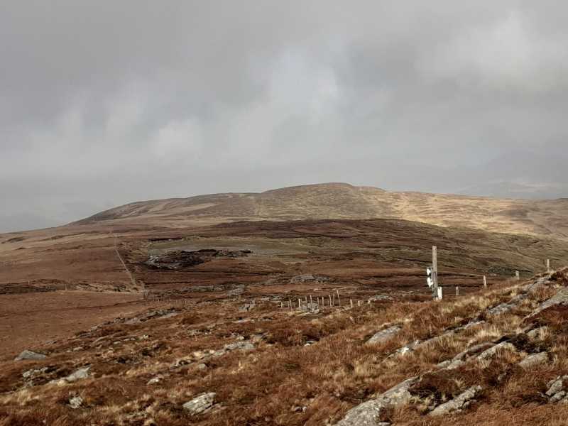
A (V987 692), but I suspect permission should be sought from there on. The ascent from Coomclogherane Top was very easy, bordering on the boring, although with lovely views down the Kenmare Bay and back into the waterfall cascading from Knocknamanagh NE Top into the lake. The south top was unspectacular, the walk from there to Knockbrack is unchallenging, but goes past an area of cleared bog/bog burst which contains a few cars that have seen better days. Moved past them, the view from Knockbrack into the Roughty Valley stretching from Kilgarvan to Kenmare and across to the Mangertons is nice, but as with the south top nothing you can’t get from its neighbours. Descended from there due west, one of the hardest descents in this part of the world as I battled broken boulders hidden by heather and ferns, thickets of furze and briars, a maze of fences all sporting barbed wire etc. Incidentally, for anyone who read my review on Knocknagullion, I have also been to a couple of raves on the western flanks of this mountain in the Bonane area...this area in South Kerry has a great musical tradition! Bonane also contains a Heritage Park which is pretty neat, especially as the two main stones in the stone circle are aligned with a large boulder on the Turners Rock-Priest Leap traverse on the horizon, known as the Altar. For those interested in the names of mountains in the area it identifies a few around Knockboy by very different names to those used here...

http://www.bonaneheritagepark.com/

I think the overall impression is that as mountains in Kerry go, these two give the least bang for your buck. If you make it to point A and access is not an issue, your eyes will inevitably be drawn to the spectacular circuit over Coomclogherane Lake to the south, which I would suggest is a much more appealing walk. Linkback: mountainviews.ie/summit/655/comment/6508/
Read Less
Read More

            MountainViews.ie picture about Knockbrack (<em>An Cnoc Breac</em>)
Picture: Knockbrack from its south top
Pleasant start to a fine circuit
by markmjcampion 16 Feb 2021
I'd have to disagree with Conor74 here...I suppose we've all got different views and that's what makes the world go round. When I'm doing a small peak or a small round I like to include a road walk as i really enjoy rambing the narrow country roads that abound out west. This time I parked outside a disused quarry at approx. B (W01411 70213) and headed on up the quiet backroad to where thomas_g parked. It was a very pleasant saunter with a mixture of forestry, farms, oddly sprayed sheep [purple in a skunk-like pattern along the back] and some nice cottages. I left the road about 500m before the farm and made straight for the summit over messy but easily-navigable terrain. Yeah, Knockbrack is a mere bump on the ridge-line [aren't we all!?] but the views are great and the promise of loftier peaks over the coming hours made for a positive buzz as I descended to the col between K and its southern neighbour. Once on the ridge the going underfoot was easy especially in February before the vernal growth spurt. From the car I was on the summit in less than 45 mins. Linkback: mountainviews.ie/summit/655/comment/22385/
Read Less
Read More
EDIT Point of Interest
text
Videos


Users Online

Guests online: 364
Recent Contributions
x
Conditions and Info
Use of MountainViews is governed by conditions and a privacy policy.
Read general information about the site.
Opinions in material here are not necessarily endorsed by MountainViews.
Hillwalking is a risk sport. Information in comments, walks, shared GPS tracks or about starting places may not be accurate for example as regards safety or access permission. You are responsible for your safety and your permission to walk.
See the credits and list definitions.

OSi logo
OSNI/LPS logo
Open Street Map
(Various variations used.)
British summit data courtesy:
Database of British & Irish Hills