Cookies. This website uses cookies, which are small text files that the website puts on your device to facilitate operation. Cookies help us provide a better service to you. They are used to track general user traffic information and to help the website function properly.

Click to hide this notice for 30 days.
Welcome to MountainViews
If you want to use the website often please enrol (quick and free) at top right.
Overview
Detail
Zoom: ??
For more map options click on any overview map area or any detail map feature.
Find Suggested Walks
Find hill, mountain, island, coastal feature.
Videos

Recent Contributions
Get Notifications

Argentina - Mendoza - Cerro de la Gloria

Argentina - Bariloche - Mirador Lago Guttierez

Argentina - Bariloche - Cascada Nivinco

Argentina - Bariloche - Cerro Llau Llau

Near Barnastooka, West Cork Mountains (Ireland)

Pookeen North Top: Only if you must

Beann there to Been that!

Milane Hill: Parking Issue

Sleamaine: Indistinct summit with fine views

Lackavrea Loop Walk

Ballinafunshoge: Clear views from the summit

Leenaun Hill Loop

Conditions and Info
Use of MountainViews is governed by conditions and a privacy policy.
Read general information about the site.
Opinions in material here are not necessarily endorsed by MountainViews.
Hillwalking is a risk sport. Information in comments, walks, shared GPS tracks or about starting places may not be accurate for example as regards safety or access permission. You are responsible for your safety and your permission to walk.
See the credits and list definitions.
Video display
Dartry Mountains Area   SW: Castlegal Hills Subarea
Rating graphic.
Crockauns West Hill Sligo County in Connacht Province, in Carn List, Dark fine-grained cherty limestone Bedrock

Height: 452m OS 1:50k Mapsheet: 16 Grid Reference: G74393 41432
Place visited by 50 members. Recently by: markwallace, annem, Colin Murphy, Overarroo, andalucia, Carolyn105, Wilderness, FrankMc1964, magnumpig, 40Shades, Sao, Wildrover, conormcbandon, bryanmccabe, Hilldweller
I have visited this place: NO (You need to be a logged-in member to change this.)

Longitude: -8.394239, Latitude: 54.320855 , Easting: 174393, Northing: 341432 Prominence: 67m,  Isolation: 1.6km
ITM: 574351 841419,   GPS IDs, 6 char: CrckWs, 10 char: CrcknsWest
Bedrock type: Dark fine-grained cherty limestone, (Dartry Limestone Formation)

Crockauns West is the 729th highest place in Ireland.

Linkback: https://mountainviews.ie/summit/612/
COMMENTS for Crockauns West 1 2 Next page >>  
Follow this place's comments
MountainViews.ie Picture about mountain Crockauns West  in area Dartry Mountains, Ireland
Picture: Copes Mtn Cairn
 
Fine view from 'cairn'.
Short Summary created by simon3, paddyhillsbagger  20 Oct 2024
There is a rough track at G720410 starA which winds its way up the East face of Copes Mtn. This almost takes you onto a rough boggy summit plateau where if you head roughly ENE to the' highest' part of the plateau a very low cairn has been 'erected'. Fine views are afforded of Glencar and its waterfall from this spot. An alternative route is from the sister summit of Crockauns G759409 starB. Head W from the summit and pick up a fence which runs roughly NW across the alternatively heathery, boggy and tussocky terrain between the two summits. There are some small rises and fences to cross, but you will reach the small cairn in about an hour.
This summit, Crockauns West used to be labelled Copes Mountain, however this is lower and further west Linkback: https://mountainviews.ie/summit/612/comment/5371/
 
MountainViews.ie Picture about mountain Crockauns West  in area Dartry Mountains, Ireland
Picture: Copes from Kings
Kings eye view
by swoop  2 May 2011
This picture takes in all that Copes has to offer , easy to access and a full days walk if you want. Linkback: https://mountainviews.ie/summit/612/comment/6332/
Your Score: Very useful <<  >>Average
 
MountainViews.ie Picture about mountain Crockauns West  in area Dartry Mountains, Ireland
Picture: Looking W to Cope's Mt. from the summit of Crockauns.
 
Last in a round of six.
by Harry Goodman  28 May 2012
I climbed Cope's Mt on 5 May 2012 as the sixth and final hill in a round of the Castlegal Mountain Group.. (For previous part of the route see my comments on Crockauns). When we set out we had intened to finish our round on Crockauns but once there, with Cope's Mt beckoning to us some 1.7k to the W, we quickly decided to take it onboard. From the top of Crockauns we went down W across a wet peat hagged col to G753410 starC before starting to climb up a trackless heather, peat hagged and hummocky slope in search of the top about 1k further along
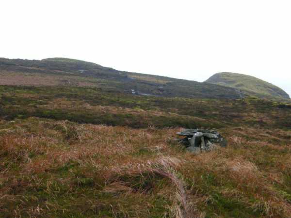
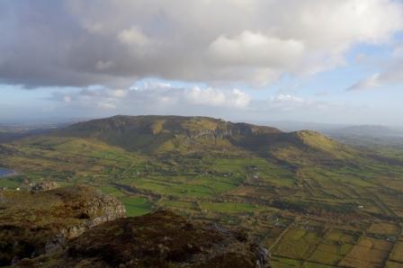
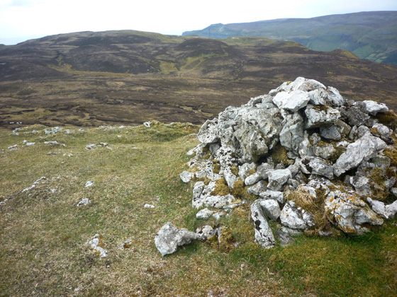
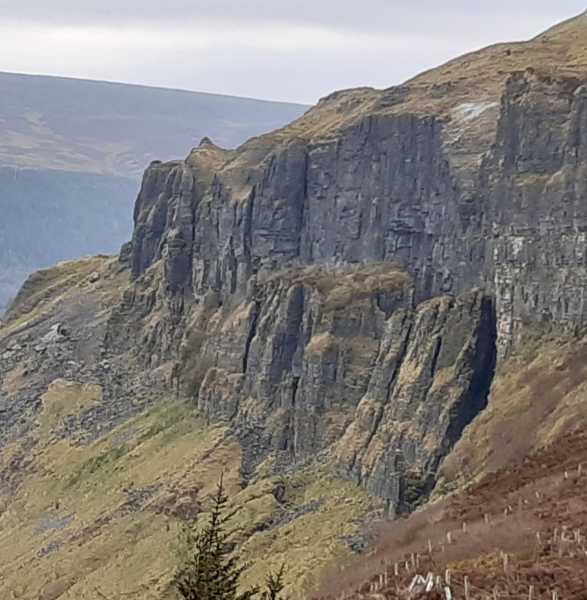
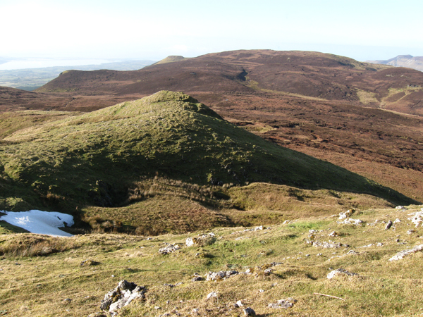
 G7439041447 starD. This involved tackling numerous heights and hollows on the way over what was the toughest terrain we had to tackle on the day. Make no mistake, while this is not a "mountain" in the true sense being only 452m, it would nonetheless be a serious place to get lost in bad visibility being an expansive sprawling trackless plateau surrounded by a steep escarpments of sheer cliffs on it's N and S rims. In such conditions very careful navigation would be essential. The flat heathery top of Cope's Mt. is undistinguised and the high point is unmarked. Indeed the OSi Sheet 16 names a lesser top Pt. 395 just over 1k further W as Cope's Mt.,which I understand, does have a summit cairn. From the top we headed generally SE, helped at times by fences leading in that general direction, to G7573640444 starE from where we made our way down a steep grassy slope to the road below where a left turn and a short walk brought us back to the start point of our round G7626940300 starF. In all our days walk covered six mv listed tops, Keelogyboy Mt., Keelogyboy Mt. SW Top, Keelogyboy Mt. NE Top, Hangman's Hill, Crockauns and Cope's Mt. and was 13.5k in length. A fine day out in an area frequently passed by on the way from Enniskillen to Sligo but not previously visited. Highly recommended but choose weather when good visability is expected and the scenery can be enjoyed.. Linkback: https://mountainviews.ie/summit/612/comment/6828/
Your Score: Very useful <<  >>Average
 
MountainViews.ie Picture about mountain Crockauns West  in area Dartry Mountains, Ireland
Excellent views
by GerryCasey  6 Apr 2021
Not much to add. Basically followed route outlined by paddyhillsbagger. Parked the car just off the road on the N16 at
G720410 starA A on the map. There's a gap in the ditch, hop over the fence and head up the field where you meet the track. Follow the track for a few kilometres, climbing a few fences, and it eventually takes you up out onto the plateau, all the while having great views of Ben Bulben plateau, Kings Mountain, Truskmore and Glencar opposite as well as Sligo Bay, Sligo Town and Knocknarea behind you. There is nothing marking the actual summit point though there is a small semblance of a cairn a few hundred metres west of the summit. From there you can view to the west the nearby summit of Craughans and south west the various summits of Keelogyboy mountains Linkback: https://mountainviews.ie/summit/612/comment/22805/
Your Score: Very useful <<  >>Average
 
MountainViews.ie Picture about mountain Crockauns West  in area Dartry Mountains, Ireland
Picture: Cope
 
madfrankie on Crockauns West, 2010
by madfrankie  8 Feb 2010
Continuing west from Crockauns we descended into a rather wet and hagged saddle before gaining Copes's heathery slopes. Like most hills in the Dartrys, Cope's Mountain's most attractive features are not necessarily it's summit. Lacking a cairn or summit marker, it still has wide views, especially across Glencar and further, to Sligo Bay. Linkback: https://mountainviews.ie/summit/612/comment/4395/
Your Score: Very useful <<  >>Average
 
MountainViews.ie Picture about mountain Crockauns West  in area Dartry Mountains, Ireland
Picture: Pockmarked surface of Copes Mountain.
simon3 on Crockauns West, 2009
by simon3  24 Dec 2009
The area around the summit of Copes Mountain looks like a battlefield, with 2 to 4m deep craters. The bog appears to be only 1 to 2m deep so these depressions must be holes in the underlying limestone.
Now wouldn't this make an interesting place for a night navigation exercise? Linkback: https://mountainviews.ie/summit/612/comment/4313/
Your Score: Very useful <<  >>Average
 
COMMENTS for Crockauns West 1 2 Next page >>
(End of comment section for Crockauns West .)

Main mapping:
Open Street Map
(Main supplier OpenTopoMap)
Height layer: © MapTiler
MapTiler Logo
British summit data courtesy:
Database of British & Irish Hills
(Creative Commons Licence)
MountainViews.ie, a Hill-walking Website for the island of Ireland. 2500 Summiteers, 1480 Contributors, maintainer of lists such as: Arderins, Vandeleur-Lynams, Highest Hundred, County Highpoints etc