This website uses cookies, which are small text files that the website puts on your device to facilitate operation. Cookies help us provide a better service to you. They are used to track general user traffic information and to help the website function properly.
Feature count in area: 44, by county: Tipperary: 36, Limerick: 8,
OSI/LPS Maps: 52, 53, 54, 58, 59, 60, 65, 66
Highest Place: Keeper Hill 691.6m
Starting Places (31) in area Midlands SW: Ballincurra Hill South, Ballyhourigan Wood Loop Walk, Barnane Lodge, Castlewaller Wood Forest Road, Coillte Knockanroe, Commanealine Wood, Commaun Beg North, Cullaun South, Cummer South, Curreeny Wood, Doonane Forest Carpark, Foildhine Mulkeir Rivers, Glenaneagh Park, Glenstal Wood CP, Gortagarry Hill West, Greenan Cross, Knockadigeen Hill SW, Knockanora East, Knockanully, Knockaviltoge East, Knockfune Wood Bend, Knockmaroe Wood, Knockmehill South, Knockteige SW, Nicker, Raven's Rock, Ring Hill West, River Doonane, The Lookout, Tobernagreana, Upperchurch
Summits & other features in area Midlands SW: Cen: Mauherslieve: Cummer 405m, Foilduff 400m, Knockmaroe 411m, Mauherslieve 543m E: Upperchurch Hills: Knockalough 427m, Knockaviltoge 364m N: Knockshigowna: Knockshigowna 212m NE: Devilsbit: Benduff 455m, Black Hill 228m, Devilsbit Mountain 480m, Gortagarry 458m, Kilduff Mountain 445m, Knockanora 433m NE: Templederry: Ballincurra Hill 403m, Commaun Beg 403m, Cooneen Hill 467m, Coumsallahaun 320m, Knockadigeen Hill 402m NW: Arra Mountains: Corbally Hill 339m, Tountinna 457m NW: Silvermine Mountains: Silvermine Mountains East Top 479m, Silvermine Mountains Far East Top 410m, Silvermine Mountains West Top 489m SE: Hollyford Hills: Falleennafinoga 388m, Foildarg 440m, Glenaneagh 420m, Gortnageragh 418m, Knockastanna 444m, Knockbane 433m, Lackenacreena 413m, Ring Hill 426m, Tooreen 457m SW: Slieve Felim: Cullaun 460m, Derk Hill 236m, Knockroe 204m, Knockseefin 235m, Slieve Felim 427m, Slieve Felim East Top 423m, Slieve Felim South Top 407m W: Keeper Hill: Bleanbeg 368m, Boolatin Top 446.6m, Keeper Hill 691.6m, Knockane 411m, Knockfune 452m
Note: this list of places may include island features such as summits, but not
islands as such.
Gortagarry, 458mHill
Place Rating ..
, Tipperary County in Munster province, in Carn Lists, Gortagarry is the 707th highest place in Ireland.
Grid Reference S03193 73207,
OS 1:50k mapsheet 59 Place visited by: 31members, recently by: Moirabourke, Arcticaurora, Krzysztof_K, JohnRea, LiamG1951, sarahryanowen, Colin Murphy, omurchu, FrankMc1964, conormcbandon, sandman, jasonmc, frankmc04, chalky, FilHil
I visited this place: NO (You need to be a logged-in member for this.)
Short or GPS IDs, 6 char: Grtgry, 10 char: Gortagarry Linkback: https://mountainviews.ie/summit/593/
Gallery for Gortagarry and surrounds
Summary
for Gortagarry :
Stupid Spruce!
Summary created by jackill
2011-12-11 09:22:43
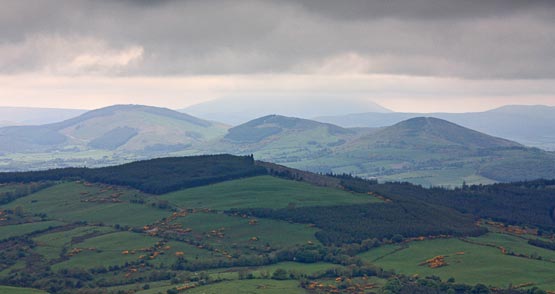
Picture: The wooded summit of Gortagarry from Devilsbit
Park at the forest entrance A (S04338 73101) room for 5 cars. There is an option to park also at the forest entrance across the road. From the forest entrance walk downhill to the north for 50 meters and enter the forest to your left on a good forestry road. Follow this road uphill to B (S03259 73379). Enter the forest here and head uphill between the parallel lines of trees, this way is fairly passable at first. After 100 meters the moss really begins to take over and the trees become lower and harder to push through. The summit area has smaller trees and more open space.
You can either go back the way you came which is bad or head directly downhill, aiming for C (S03313 73032), which is also bad. Heading directly downhill does cut the walk distance.
Gortagarry, ah yes a rare thing that, a hill entirely covered in young Sitka spruce. As of 2008 anyway from whatever side you start you have around 80 to 120m of what orienteers call "fight" to reach the summit and even then it's a little tricky to be sure you are there. Only for the purist until the trees start getting thinned.
While this photo has dramatic sky it certainly wasn't taken on a clear picture postcard day. Still Gortagarry is a good place to see some of the northern mountains in the Shannon area. The three dancing maidens in the middle ground are, from left to right, Cooneen Hill, Ballincurra Hill and Knockadigeen Hill, all between 400 and 500m.
The higher summit behind Ballincurra Hill is Keeper Hill (694m) the monarch of the Shannons. The high ground in front of Keeper and behind the three sisters are the Silvermines. The low wooded bumps nearer to us are the northern echoes of Knockanora.
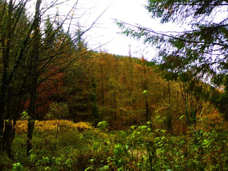
Picture: The highlight of my walk - some nice autumnal colour.
No laughing matter
by Colin Murphy
15 Nov 2021
A local informed me that Gortagarry means 'Field of laughter' from gort (field) and gáire (laughter), but given the torture of hacking my way through the forested area of the summit, the experience was anything but humorous. Followed jackal's excellent route for an easy ascent up forest tracks, except for the last aforementioned 100m or so. Unless you're a bagger, stay away, because the hill will have the last laugh. Linkback: mountainviews.ie/summit/593/comment/23350/
Read Less
Read More
ahendroff on Gortagarry
by ahendroff
20 May 2008
The summit of Gortagarry is enveloped in pine trees. There is a bit of a clearing in what may be potentially the "summit" but it's a fair bash into the trees and is for die-hard baggers only. Thanks to Simon's GPS and gentle beckoning we would have never made it back out! Zip up all your pockets for this one if you don't want to spend a considerable amount of time picking out pine needles before the wash .... Linkback: mountainviews.ie/summit/593/comment/3114/
Read Less
Read More
YoungJohn on Gortagarry
by YoungJohn
19 Feb 2010
climbed Gortagarry today,18th Feb 10, with my two (usual suspects) friends accompanied by jack a ferocious terrier. The mountain is as other commentators have said, covered in stika spruce. There are some grand views when the tree cover is broken. We walked a loop around the mountain taking us just short of two hours. An enjoyable walk and another hill bagged. We did get to see the silver loughderg, the aughtys, Keeper, Knockanora and the silvermines. To the south Slievenamon and the Galtees, Knockmealdowns and comeraghs, our view to the north was obstructed by 'The Bit'. Linkback: mountainviews.ie/summit/593/comment/4406/
Use of MountainViews is governed by conditions and a privacy policy.
Read general information about the site. Opinions in material here are not necessarily endorsed by MountainViews.
Hillwalking is a risk sport. Information in comments, walks, shared GPS tracks or about starting places may
not be accurate for example as regards safety or access permission. You are responsible for your safety and your permission to walk.
See the credits and list definitions.


 Our Facebook page.