Cookies.
This website uses cookies, which are small text files that the website puts on your device to facilitate operation. Cookies help us provide a better service to you. They are used to track general user traffic information and to help the website function properly.
Features
Nearby features appear when you click the map.
Declutter tracks on map.
Place Search
Video
X
Pub: by
Donegal SW Area , N: Sliabh Tuaidh Subarea
Feature count in area: 24, all in Donegal, OSI/LPS Maps: 10
Highest Place: Slieve League 596.4m

Starting Places (1) in area Donegal SW:
Port Pier

Summits & other features in area Donegal SW:
Maum 325m
N: Sliabh Tuaidh: Tormore Island South 94m, Tormore Island North 139m, Crockuna 400m, Slievetooey 511m, Slievetooey Far West Top 460m, Slievetooey West Top 472m
NE: Glengesh: Balbane Hill 472m, Glengesh Hill 390m, Common Mountain 499.7m, Crocknapeast 497m, Croaghavehy 372m, Mulmosog Mountain 351m, Mulnanaff 475m
NW: Glencolmkille: Croaghacullion 374m, Croaghloughdivna 310m
S: Killybegs Hills: Croaghacullin 405m, Croaghmuckros 275m, Crownarad 493m, Crownarad SW Top 471m
SW: Slieve League: Crockrawer 435.2m, Leahan 427m, Slieve League 596.4m, Slieve League SE Top 576.7m

Note: this list of places may include island features such as summits, but not islands as such.
Rating graphic.
Slievetooey Far West Top, 460m Hill Sliabh Tuaidh (mullach i gcéin thiar) A name in Irish,
Place Rating ..
For origin of name, see Sliabh Tuaidh / Slievetooey., Donegal County in Ulster province, in Carn Lists, Sliabh Tuaidh (mullach i gcéin thiar) is the 694th highest place in Ireland.
Grid Reference G59340 90410, OS 1:50k mapsheet 10
Place visited by: 51 members, recently by: bryanmccabe, Aongus, andalucia, eamonoc, markmjcampion, LorraineG60, MichaelG55, fingalscave, kitchen, Fergalh, CaptainVertigo, Ian_Taylor, Peter Walker, Aidy, hgboyle
I visited this place: NO (You need to be a logged-in member for this.)
Longitude: -8.632365, Latitude: 54.759961, Easting: 159340, Northing: 390410, Prominence: 55m,  Isolation: 2.5km
ITM: 559298 890401
Bedrock type: Whitish quartzite with pebble beds, (Slieve Tooey Quartzite Formation)

  Short or GPS IDs, 6 char: SlvtFr, 10 char: SlvtyFrWst

Linkback: https://mountainviews.ie/summit/580/
Gallery for Slievetooey Far West Top (Sliabh Tuaidh (mullach i gcéin thiar)) and surrounds
Summary for Slievetooey Far West Top (Sliabh Tuaidh (mullach i gcéin thiar)): Easy ascent from east
Summary created by Colin Murphy 15 Apr, 2016
            MountainViews.ie picture about Slievetooey Far West Top (Sliabh Tuaidh (mullach i gcéin thiar))
Picture: The Three Tooeys
Usually done in conjunction with Slievetooey and Slievetooey West Top. See those for parking and route information.
On a clear day, Far West Top is quite evident - a gently rising hump 2.5km to the west of West Top over a gently undulating plateau. Head directly west from West top summit - it is easy going , firm terrain and you will reach the base of the top after about 40 minutes. The slope increases for the final ascent, but you will only have to climb 50m to reach the top, which is marked by a cairn of sorts, and has wonderful views of the coastline further west.
Return the way you came, but skirting to the south of West Top, cross the col and partially ascend Slievetooey again to point A (G625 900), then descend to the SE until you reach the paved lane at B (G634 888). Time for entire 3-top roundtrip is 4.5 - 5 hours.
Pic from summit shows Slievetooey on right and Slievetooey West Top on left.
Linkback: mountainviews.ie/summit/580/comment/5339/
Member Comments for Slievetooey Far West Top (Sliabh Tuaidh (mullach i gcéin thiar))

            MountainViews.ie picture about Slievetooey Far West Top (Sliabh Tuaidh (mullach i gcéin thiar))
Picture: northern cliffs
gerrym on Slievetooey Far West Top
by gerrym 6 Jun 2009
There is no doubt that to fully appreciate this hill an approach must be made from the western seaboard, where ground falls precipitously over 1000ft to a battered Atlantic coast. I started from Glencolumbkille - giving a walk to the top of 15km and 4.25 hours along some of the most spectacular scenery in the country. Parking at C (G526 874), beside a slipway to the tidal reaches of the Merlin river.

A short road walk brings a track uphill to a signal tower at 222m (all part of a waymarked loop walk). The stunning views are turned up here and the dial can only go higher. A filmsy fence separates the 200m drop as walk along the clifftop to the dramatically jagged height of Sturrall. Walk along lower cliffs to the little harbour at Port (D (G548 890)), surrounded by hills and striking seastacks. Could also start from here as there is ample parking.

Climb up from sea level to cliffs over 200m again on Port Hill before dropping steeply down to the Glenlough river (E (G572 910)) - above one of the most dramatic storm beaches you are ever likely to see. Now the climb is really on as gain sight of the line of high cliffs where Sliabh Tuaidh meets the Atlantic and spawns a myriad of different sized and shaped seastacks. Continued height gain brought me to a point where the GPS read 365m to the water below. Rising air created mist near the top of the cliffs and hugged the ground at the top before disappearing. In this period of murk the seastacks took on an other worldly appearance and shafts of light created biblical areas of golden calm out to sea.
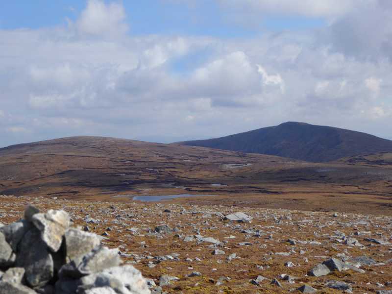
Head S for the top as the ground starts to drop along the coast towards Gull Island, looking across to Lough Anaffrin nestling below steep slopes. The top is quite stoney and has a number of small cairns. Views extend back along the coast already walked and north along coast to come, the height of Errigal and the Derryveagh mtns and the Bluestacks, south over Donegal Bay to the sharp line of Benbulben and the low line of the Ox mtns.

This was part of a 2 day walk and i camped beside the summit cairn but there is plenty of scope for different options to explore this hill and surrounding coast. (A fuller description will appear in the walks section). Linkback: mountainviews.ie/summit/580/comment/3818/
Read Less
Read More

            MountainViews.ie picture about Slievetooey Far West Top (Sliabh Tuaidh (mullach i gcéin thiar))
Picture: The beauty of the Donegal coastline
High seas
by Colin Murphy 15 Apr 2016
From the summit of Slievetooey Far West Top, the views along the coastline to the west are quite spectacular. Tormore Island, which rises to 139M is visible on the left of the picture. Linkback: mountainviews.ie/summit/580/comment/18493/
Read Less
Read More

            MountainViews.ie picture about Slievetooey Far West Top (Sliabh Tuaidh (mullach i gcéin thiar))
Picture: Overlooking Lough Anaffrin
All About The Journey, Not The Destination
by Aidy 14 May 2018
I had a mixed day weatherwise, with dark skies, rain and flat light one minute, and blue skies the next, but it only added to the spectacular views to be had from the summit. If anything, the views on the approach if you come from the west at Port, are even more amazing along the coastal cliffs. On the way back I headed for Port Hill more directly, and found an unexpected bonus in the views around Lough Anaffrin - a stunning spot, tucked away from most eyes. Beautiful part of the country. Linkback: mountainviews.ie/summit/580/comment/19930/
Read Less
Read More

            MountainViews.ie picture about Slievetooey Far West Top (Sliabh Tuaidh (mullach i gcéin thiar))
Picture: http://www.youtube.com/watch?v=QgXDf6kSN5Q
Finest Coastal Walk?
by CaptainVertigo 11 Oct 2014
Gerrry McVeigh's YouTube masterpiece "The Finest Coastal Walking in Ireland (Walks around Port in Donegal)" throws down the gauntlet to the rest of you who think otherwise. But no matter how wonderful your bit of coast may be it's hard to know if you will be able to capture its essence as perfectly as McVeigh has done here. The nominal goal of the walk will be Slievetooey Far W Top but the fact is that the whole route is top class.
The YouTube description says:
A walk along some of the finest coast in Ireland in the far west of Donegal. Starting in remote An Port and climbing up to reach a stunning stretch of cliffs, passing above sea stacks of all shapes and sizes. Dropping to sea level to visit the amazing storm beach at Glenlough Bay, watching seals and rivers dropping into the Atlantic. Climbing steeply to even higher cliffs and to Slievetooey Far West Top at over 1,500 ft.
Gerry has uploaded the exact route here at TRACK 2176. A short quote from his write up:
The cliffs kept rising and rising to over 1,000 feet before the pull of Slievetooey tore me away. Across the water to the north and west snow capped mountains told a tale of the harsh late March weather. A stiff breeze told me how cold it was as my boots crunched over patches of old snow. The broad stoney top of Slievetooey Far West Top at over 1,500 feet gave a vantage point back over the wild coast just travelled. From the summit cairn the clear air gave views across Donegal Bay to the mountains of Sligo, the Bluestack Mountains and the iconic hills to the north of Donegal.
Check out Gerry's Track and watch his movie. And I hope that, some day, you'll experience the real thing Linkback: mountainviews.ie/summit/580/comment/17724/
Read Less
Read More
EDIT Point of Interest
text
Videos


Users Online

Guests online: 323
Recent Contributions
x
Conditions and Info
Use of MountainViews is governed by conditions and a privacy policy.
Read general information about the site.
Opinions in material here are not necessarily endorsed by MountainViews.
Hillwalking is a risk sport. Information in comments, walks, shared GPS tracks or about starting places may not be accurate for example as regards safety or access permission. You are responsible for your safety and your permission to walk.
See the credits and list definitions.

OSi logo
OSNI/LPS logo
Open Street Map
(Various variations used.)
British summit data courtesy:
Database of British & Irish Hills