This website uses cookies, which are small text files that the website puts on your device to facilitate operation. Cookies help us provide a better service to you. They are used to track general user traffic information and to help the website function properly.
Feature count in area: 30, all in Galway,
OSI/LPS Maps: 37, 38, 44, 45, EW-CON, MSW
Highest Place: Tully Mountain West 306m
Starting Places (66) in area Galway Coastal Hill: Angler's Return, Aughrusbeg Lough, Ballyconneely, Ben Lettery Hostel, Brandy Harbour, Bridge St Clifden, Bundouglas Bay, Bunnageeha, Cashel Church, Cleggan House, Cloonsie Quay, Cnoc Mordáin, Connemara National Park Visitor Centre, Coorhoor Lough North, Dernasliggaun, Dogs Bay Beach, Emlaghdauroe Bridge, Emlaghdauroe South, Eragh Island South, Fee Lough SW, Foher, Furnace, Fuschia Lane, Glencoaghan River Bridge, Glenmore, Gort Mór, Gortdrummagh West, Illaunroe North, Illaunroe South, Inaghbeg Path, Inchamakinna, Inishlay, Inishnee Bridge, Kilkieran South West, Lettercallow School Road, Letterfrack Lodge, Lettergesh Beach, unuseableLettermullen Pier, Loch Chamais, Lough Anivan Bend, Lough Auna S, Lough Fee East, Lough Nafiddaun South, Lough Natawny, Lough Tanny, Mace Head, Muck Lough NW, Mweenish Cemetary, Nacreeva Lough, Nambrackkeagh Lough, Omey Strand, Owen na Baunoge River, Owengar Bridge, Ros an Mhíl, Ross Beach, Ross Point, Ross Quay, Roundstone, Skeaghatimull, Sky Road, The Big Ring, Tievegarriff, Toombeola Bridge, Water Reservoir, Water Tank, Water Tank Carna
Summits & other features in area Galway Coastal Hill: Ardagh 49m, Ardbear N 64m, Ballynew 84m, Barraderry 68m, Camus Eighter 72m, Camus Hill 96m, Cleggan Beacon 61m, Cuilleen 97m, Dawros More North 41m, Derryadd West 127m, Derrygimlagh West 41m, Derrylahan 49m, Doon Hill 67m, Faul 50m, Foher 223m, Gortmore 122m, Kilkieran 165m, Kinvarra 67m, Knockfin 49m, Lehid 53m, Lettercallow 109m, Mannin Beg 41m, Maum 62m, Murneen 73m, Murvey 81m, Rossaveel 48m, Shanboolard 85m, Streamstown East 79m, Streamstown West 103m, Tully Mountain West 306m
Note: this list of places may include island features such as summits, but not
islands as such.
Lettercallow, 109mCoastal Hill Leitir Calaidh A name in Irish,
Place Rating ..
Name from OSI, Galway County in Connacht province, in no lists Grid Reference L86959 29149,
OS 1:50k mapsheet 44 Place visited by: 9members, recently by: oakesave, markmjcampion, eamonoc, Fergalh, mdoc1969, melohara, magnumpig, Caithniadh, sandman
I visited this place: NO (You need to be a logged-in member for this.)
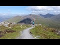
Picture: Looking towards the summit from the start of the hike
Easy stroll for some nice views
by markmjcampion
30 Sep 2022
I cycled over from Bealdangan and left the bike just after a couple of bungalows. It was only when I started walking that I spotted that you can also head off from the nearby, obvious concrete water tank where there is room for a few cars at WatrTk (L87677 29677). I headed directly for the summit over pleasant terrain of flat rock and bog. It was all commonage with no fences to contend with and it took about 20 mins at an easy pace. Good views over to Cnoc Mordáin and a lot of the islands in Kilkieran Bay were lit up by a declining sun. I headed more or less due north from the summit to pick up the track detailed on the map but I'd advise others to retrace their steps from the summit instead to avoid having to climb walls and cross fences. Linkback: mountainviews.ie/summit/5032/comment/21376/
Read Less
Read More
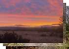
Picture: Summit Area.
Coastal Hill
by sandman
30 Sep 2022
By parking at LC Sch Rd (L87600 28966) you can walk on to open hillside with no access issues . A gentle ascent to the summit area which unlike its nearest neighbour has no seating arrangements for the visitor. Linkback: mountainviews.ie/summit/5032/comment/19567/
Use of MountainViews is governed by conditions and a privacy policy.
Read general information about the site. Opinions in material here are not necessarily endorsed by MountainViews.
Hillwalking is a risk sport. Information in comments, walks, shared GPS tracks or about starting places may
not be accurate for example as regards safety or access permission. You are responsible for your safety and your permission to walk.
See the credits and list definitions.


 Our Facebook page.