This website uses cookies, which are small text files that the website puts on your device to facilitate operation. Cookies help us provide a better service to you. They are used to track general user traffic information and to help the website function properly.
Feature count in area: 38, all in Donegal,
OSI/LPS Maps: 1, 11, 2, 6
Highest Place: Errigal 751m
Starting Places (29) in area Derryveagh Mountains: Aleahan Lough, Altderry Bridge, An Chúirt Hotel, Astelleen Burn Waterfall, Derryreel Lough, Dunlewy Lough E, Dunlewy Lough Viewing Point, Errigal Hostel, Errigal Parking, Glenveagh Bridge, Glenveagh National Park SW, Glenveigh Castle, Keel Lough N, Losset North, Lough Acrobane Farmhouse, Lough Ascardan, Lough Barra Slipway CP, Lough Barra W, Meenagoppoge Burn Bridge, Mín Uí Bhaoil, Muckish Gap Shrine, Muckish North Access Road, Nabrackbaddy Lough, Procklis Lough, River Barra Bridge NE, River Barra Bridge SW, Sand Lough NE, Sruhancrolee Bridge, Stranamarragh Bridge
Summits & other features in area Derryveagh Mountains: Cen: Dooish: Dooish 651.5m, Dooish SW Top 528m, Dooish SE Top 553.9m, Saggartnadooish 506.4m, Saggartnadooish East Top 478.9m Cen: Errigal: Errigal 751m, Mackoght 555m Cen: Glenveagh Upper: Crockfadda 485m, Crockfadda East Top 454m, Crockballaghgeeha 480m, Crockmulroney 430m, Staghall Mountain 486m, Croaghnasaggart 480m, Maumlack 480m Cen: Lough Keel (Meencorwick): Crockglass 489m, Addernymore 416m, Grogan More 457m, Crocknafarragh 517m, Crocknafarragh SE Top 470m Cen: Slieve Snaght: Crockfadda 529m, Crockfadda NE Top 502m, Crocknasharragh 495m, Drumnalifferny Far NE Top 535m, Bingorms 578m, Drumnalifferny Mountain 596m, Drumnalifferny Mountain NE Top 585m, Slieve Snaght 678m N: Aghla: Aghla Beg 563.9m, Aghla Beg South Top 602.3m, Aghla More 581.2m, Ardloughnabrackbaddy 472.5m, Crocknalaragagh 470.6m N: Muckish: Muckish 667.1m, Croaghaderry 222m, Crockawama 238m, Derryreel 232m S: Doochary: Croaghleconnell 266m S: Dungloe: Crovehy 315m
Note: this list of places may include island features such as summits, but not
islands as such.
Crocknasharragh, 495mHill Cnoc na Searrach A name in Irish,
Place Rating ..
Ir. Cnoc na Searrach [logainm.ie], 'hill of the foals’, Donegal County in Ulster province, in Carn Lists, Cnoc na Searrach is the 585th highest place in Ireland.
Grid Reference B89760 12741,
OS 1:50k mapsheet 1 Place visited by: 24members, recently by: Colin Murphy, AlanReid, markmjcampion, eamonoc, Lucky1, trostanite, finkey86, melohara, shaunkelly, kmoore, r254donegal, simoburn, David-Guenot, Wilderness, Fergalh
I visited this place: NO (You need to be a logged-in member for this.)
Longitude: -8.160644, Latitude: 54.962094, Easting: 189760, Northing: 412741,
Prominence: 80m, Isolation: 1.5km ITM: 589711 912727 Bedrock type: Coarse biotite granite & granodiorite, (Main Donegal Granite) Notes on name: Named Crockatarrive on the 1st series of 6" maps.
Short or GPS IDs, 6 char: Crckns, 10 char: Crcknshrgh Linkback: https://mountainviews.ie/summit/472/
Gallery for Crocknasharragh (Cnoc na Searrach) and surrounds
Summary
for Crocknasharragh (Cnoc na Searrach):
All a bit of a slog but well worth it!
Summary created by Harry Goodman
2012-08-16 19:58:17
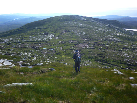
Picture: Walker making for Crocknasharragh from Crockfadda.
Park off road at Sruhcrol (B93314 12721) just S of a bridge over the Sruhancrolee stream . If conditions are clear look up SW to the sharp pointed knoll at the E end of the rocky escarpment rising above L Barra. Go NW up the grassy hillside and gradually swing W to gain the high ground A (B930 128) at the back (N) of the pointed knoll and some 500m along from the start. Go NW up the slope and then down to the saddle below Crocknasharragh B (B906 133), some 2k in all. Change direction to SW and a further 1k up the slope arrive at the summit marked by a trig pillar and an adjacent cairn. Views fron this relatively small hill amidst the higher tops of Derryveigh are both exceptional and extensive. Return by way of ascent but note that the route can be used either as the start or finish in a round which would also include Crocfadda and Crockfadda NE Top.
I climbed this hill on 26 July 2012 as the final top in a round of six that had started with Bingorms on a climb up from the R254 near L Barra. (For previous part of route see my comments on Crockfadda.) The climb up from the saddle B (B906 133) below Crockfadda was about 1k, over grass and heather with some rocky patches, to the rock covered flat summit area. The top is marked by a trig pillar and an adjacent cairn near to a cluster of large granite boulders one of which sat up vertically like an ancient standing stone some two metres high. The views from the top of this hill, the lowest in my round, were both exceptional and extensive. To the NE was Errigal and the fine line of tops of the Glover Highlander stretching back to Muckish. To the W and S was an extensive panorama which included Aranmore Island, Slievetooey, Slieve League and the long ridge of the Bluestacks fronted by Scraigs and Agla Mt. From the top I descended back to the saddle below Crockfadda before heading SE (right) to gain the crest of the SE spur of Crockfadda and following it down some 2k to A (B930 128) near a small pointed knoll, high above L Barra. Then keeping the knoll on my right, to avoid the dangerous and precipitous rocky face falling down to the road, I went NE down and around a more gentle but energy sapping trackless short slope through tough long grass for some 500 metres to my parking place at Sruhcrol (B93314 12721). The route of my descent could be used for an out and back climb of Crocknasharragh. Linkback: mountainviews.ie/summit/472/comment/14747/
Read Less
Read More
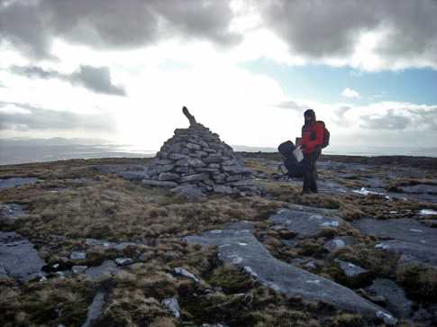
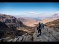
Picture: Summit area
eflanaga on Crocknasharragh
by eflanaga
21 Jul 2008
Not so much a comment as a picture of the summit area. This taken off yours truly during ML assessment in March of this year. The mountains in the background are the Croaghgorms (Bluestacks). Easy ascent from Crockfadda over good ground. Rock/slab strewn summit with great views as is the case for most of the tops in this range. Linkback: mountainviews.ie/summit/472/comment/3243/
Read Less
Read More
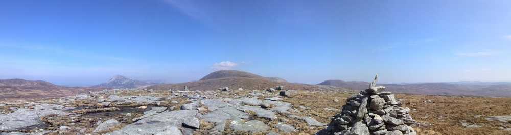
Picture: At the top!
View from Crocknasharragh
by r254donegal
21 Apr 2015
Errigal, top left. Snaght in the middle. Crockfadda in the middle foreground with the top of moylenanav in the far right Linkback: mountainviews.ie/summit/472/comment/17942/
Use of MountainViews is governed by conditions and a privacy policy.
Read general information about the site. Opinions in material here are not necessarily endorsed by MountainViews.
Hillwalking is a risk sport. Information in comments, walks, shared GPS tracks or about starting places may
not be accurate for example as regards safety or access permission. You are responsible for your safety and your permission to walk.
See the credits and list definitions.


 Our Facebook page.