Cookies.
This website uses cookies, which are small text files that the website puts on your device to facilitate operation. Cookies help us provide a better service to you. They are used to track general user traffic information and to help the website function properly.
Features
Nearby features appear when you click the map.
Declutter tracks on map.
Place Search
Video
X
Pub: by
Sperrin Mountains Area , E: Magherafelt Hills Subarea
Feature count in area: 64, by county: Derry: 34, Tyrone: 39, of which 9 are in both Derry and Tyrone, OSI/LPS Maps: 12, 13, 6, 7, 8
Highest Place: Sawel 678m

Starting Places (21) in area Sperrin Mountains:
Altinure Road, Banagher Glen Nature Reserve, Barnes Gap Car Park, Crocknakin, Drumnaspar Picnic CP, Glenchiel Road, Glenedra Bridge, Glenelly Road, Parkreagh, Goles Road, Lough Ouske, Moneyneany Village, Moydamlaght Forest, Moydamlaght Road, Mullaghmore, Mullaghbane, Spaltindoagh, Sperrin Hamlet, Sperrin Heritage Centre, Sperrin Heritage Centre W, Sperrin Road, Barnes Top, Sperrin Road, Glashagh Bridge, Sperrin Road, Sperrin

Summits & other features in area Sperrin Mountains:
E: Magherafelt Hills: Slieve Gallion NE Top 493.6m
E: Magherafelt Hills: Slieve Gallion 526.6m
N: Claudy Hills: Crockdooish 321m, Curradrolan Hill 270m, Eglish 277m, Letterlogher 249m, Mullaghmeash Hill 244m, Slieveboy 259m, Straid Hill 303m
NE Cen: Glenelly North East: Barnes Top 456m, Craigagh Hill 460m, Crockbrack 526.1m, Knockanbane Mountain 441m, Meenard Mountain 620m, Meenard Mtn W Top 480m, Mullaghaneany 627m, Mullaghash 480m, Mullaghsallagh 485m, Oughtmore 569m, Spelhoagh 568m
NE: Glenshane North: Benbradagh 465m, Boviel Top 454m, Carn Hill 448m, Carntogher 464m, Moneyoran Hill 414m
NE: Glenshane South: Bohilbreaga 478m, Coolnasillagh Mountain 423m, Corick Mountain 430m, Crockalougha 407m, Mullaghmore 550m, White Mountain 537m
NW Cen: Glenelly North West: Dart Mountain 619m, Dart Mountain North-West Top 525m, Learmount Mountain 489m, Learmount Mountain South Top 492m, Mullaghasturrakeen 581m, Mullaghcarbatagh 517m, Mullaghclogha 635m, Mullaghclogher 572m, Mullaghdoo 568m, Sawel 678m
NW: Maheramason Hills: Clondermot Hill 220m, Gortmonly Hill 218m, Slievekirk 370m
SE Cen: Glenelly South East: Carnanelly 562m, Carnanelly West Top 503.4m, Mullaghbane 467m, Mullaghturk 416m
SE: Cookstown Hills: Cregganconroe 300m, Fir Mountain 362m, Oughtmore 382m
SW Cen: Glenelly South West: Clogherny Top 408m, Craignamaddy 385m, Crocknamoghil 335m, Mullaghbolig 442m, Spaltindoagh 420m
SW: Mullaghcarn: Curraghchosaly Mountain 416m, Mullaghcarn 542m, Mullaghcarn South Top 525m
SW: Newtownstewart Hills: Bessy Bell 420m, Mullaghcroy 242m
W: Strabane: Balix Hill 403m, Knockavoe 296m, Owenreagh Hill 400m

Note: this list of places may include island features such as summits, but not islands as such.
Rating graphic.
Slieve Gallion NE Top, 493.6m Hill Sliabh gCallann (mullach thoir thuaidh) A name in Irish,
Place Rating ..
For origin of name, see Slieve Gallion., Derry County in Ulster province, in Carn Lists, Slieve Gallion NE Top is the 591st highest place in Ireland. Slieve Gallion NE Top is the most easterly summit in the Sperrin Mountains area.
Grid Reference H81392 89625, OS 1:50k mapsheet 13
Place visited by: 88 members, recently by: mountainmike, Tricia-Mulligan, lauracardiff, trostanite, Claybird007, jlk, newpark-cc, Paddym99, Sperrinwalker, garybuz, annem, Lucky1, Hoverla, osullivanm, simon3
I visited this place: NO (You need to be a logged-in member for this.)
Longitude: -6.736846, Latitude: 54.747982, Easting: 281392, Northing: 389625, Prominence: 46m,  Isolation: 2.4km
ITM: 681323 889616
Bedrock type: Olivine basalt lava, (Lower Basalt Formation)

  Short or GPS IDs, 6 char: Slv494, 10 char: SlvGlnNETp

Linkback: https://mountainviews.ie/summit/470/
Gallery for Slieve Gallion NE Top (Sliabh gCallann (mullach thoir thuaidh)) and surrounds
Summary for Slieve Gallion NE Top (Sliabh gCallann (mullach thoir thuaidh)): Top easily reached from road with great views to east of the Sperrins.
Summary created by simon3, Colin Murphy 2021-09-02 08:03:55
            MountainViews.ie picture about Slieve Gallion NE Top (<em>Sliabh gCallann (mullach thoir thuaidh)</em>)
Picture: Summit cairn just north of mast
Taking the A29 north from Moneymore, after a few hundred metres you will see the Tullynagee road on the left, signposted for S. Gallion. This road continues almost all the way to the summit of S. Gallion NE Top, which is topped by a tall telecoms mast. There is a large area to park. The highest point (non-man made) however, lies about 150m further north, and is marked by a cairn and a wooden post.
Linkback: mountainviews.ie/summit/470/comment/5229/
Member Comments for Slieve Gallion NE Top (Sliabh gCallann (mullach thoir thuaidh))
Comment create / edit display placeholder

            MountainViews.ie picture about Slieve Gallion NE Top (<em>Sliabh gCallann (mullach thoir thuaidh)</em>)
Mountain of the Heights
by gerrym 11 Feb 2014


http://youtu.be/ys5XhaOpqYM
http://youtu.be/teE-IzY5Or0

The recent cold spell has created stunning winter conditions in the Sperrins. The favoured approach is from the large layby at Iniscarn Wood (A (H833 907)). Roads were reasonably clear but thick ice sheathed the layby and as i was changing footwear the car started to slide despite handbrake and in 1st gear!

A straight forward track heads through the forest, passing an abandoned house and woodpiles past 'gate 2'. A carpet of snow had been through the freeze/thaw cycle and the path was very icy. With height the snow was more pristine and walking was easier, allowing eyes to rise to capture the opening views across to the line of Antrim Hills defined by thier similar white dressing. A narrow rough track begins where the forest track ends, rising further up the flank o f the hill. Power lines cross this track and a clear line to the summit follows thier swathe. This is a steep haul and i could imagine the wooden poles lifting skiers to the top (there was an idea from a local farmer at one stage - maybe if future winters are like this?).

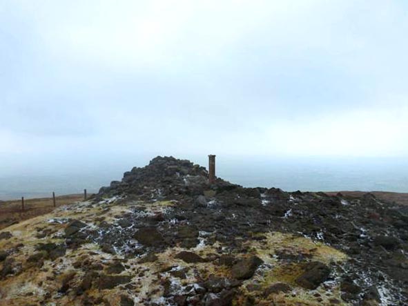
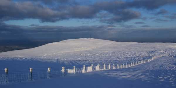
Coming out from the trees i followed the trail left by others through the windswept powder snow to a stile. Creative new signs have been put in place over the hill guiding to the tops - they do the job in a very natural way. The communications masts loomed out of the total whiteness that was the hillside, with snow drifted 2-3 feet alongside thier protective fence. I stopped beside a telegraph pole to take some pics and a large chunk of ice fell and glanced off my hand - a timely reminder not to do that again!

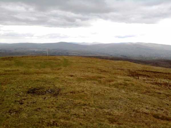
Views were spectacular with the contrast in colour from the brilliant white of the snow on top to the drab browns and greens of the Lough Neagh basin. To the east the Antrim Hills were doing as well with the wintry weather and Divis had a crown of white. Most breathtaking were the views west to the rest of the Sperrins - they had a real bright cold white look which shone strongly in the full sun. I suppose if i was to get too lyrical it was a virginal perfection, with no blemishes.

There were a few other hardy souls knocking about the top as i took the road from the summit which was just about visible. Heading for the true top was a bit more difficult as the bog road was filled in with 4-5 feet of snow. But it was great fun tramping a path withwind sculpured snow, half buried fences, blue skies, magnificent views and a fresh wind to cool me down from the heat being generated. Return was back to the road which i followed downhill to take an extremely icy farm track back to the road and car.

A truely amazing experience on Slieve Gallion which just brings a smile to my face thinking about it. With this weather set to last for a while give it a visit and experience it for yourself! Linkback: mountainviews.ie/summit/470/comment/4317/
Read Less
Read More

            MountainViews.ie picture about Slieve Gallion NE Top (<em>Sliabh gCallann (mullach thoir thuaidh)</em>)
Picture: Looking towards the higher Sperrins from Slieve Gallion NE Top
by slemish 29 May 2010
Since I was already climbing Slieve Gallion today it required virtually no extra effort to bag the NE Top as well. The Tullynagee road from Moneymore extends all the way up to the car park at the ugly transmitter station. Incidentally this car park is the highest point on a public road in Northern Ireland climbing to an impressive 490m (B (H813 894)). The 496m summit cairn is about 100m behind the mast - just a short stroll. Like the main summit of Slieve Gallion the views from the NE summit are incredible if you're lucky enough to get a clear day like today. The county tops of seven different counties were visible - Sawel looked particularly majestic in the afternoon sunshine - as well as numerous smaller summits throughout the north of Ireland. I would recommend this mountain to anyone who loves long views - you really can see for miles in every direction. Linkback: mountainviews.ie/summit/470/comment/5834/
Read Less
Read More

            MountainViews.ie picture about Slieve Gallion NE Top (<em>Sliabh gCallann (mullach thoir thuaidh)</em>)
Picture: Summit Cairn with the TV Mast and Sun Behind (taken with a dodgy mobile phone!)
dino on Slieve Gallion NE Top
by dino 22 Dec 2007
Climbed on December 21st 2007. I had a longer walk planned for today but in the end up fancied something shorter and more simple. I got the route for this one from a guide called "Landscapes in Stone - Walk The Sperrins", loaded a track on the GPS and away I went (without the route card which was a bit of a mistake at one point). I wish I had taken the time to check my map better and to read here as I didn't realise there was a second peak and a trigpoint to be had with just a short extension of the walk. I guess it gives me a chance to go back again.

The guide follows pretty much the same route as described by gerrym for Slieve Gallion proper but descends from the turn off for Slieve Gallion to pick up a number of good farm lanes that bring you gently back to the Iniscarn Road about 200m from the forest gate.

The one and only problem I had was at the end of the forest track below the summit. Instead of following the muddy track that gerrym mentions I turned right along a faint path that eventually became an overgrown drainage channel and ended up perilously crossing about 10m of ancient and crumbling brashing which could have resulted in a nasty accident. Be careful if you are following the same guide.

Views from the summit cairn were good but most of the distant sights were obscured by the persistent mist lying over Lough Neagh and in many of the valleys. The summit cairn still made a great windbreak and provided a comfortable seat to have lunch and admire what I could see.

The descent via the aforementioned lanes was quick, easy and painless and I was back at the parking spot in less than 3 hours which included 15mins for lunch. Linkback: mountainviews.ie/summit/470/comment/2926/
Read Less
Read More
EDIT Point of Interest
text
Videos


Recent Contributions
x
Conditions and Info
Use of MountainViews is governed by conditions and a privacy policy.
Read general information about the site.
Opinions in material here are not necessarily endorsed by MountainViews.
Hillwalking is a risk sport. Information in comments, walks, shared GPS tracks or about starting places may not be accurate for example as regards safety or access permission. You are responsible for your safety and your permission to walk.
See the credits and list definitions.

OSi logo
OSNI/LPS logo
Open Street Map
(Various variations used.)
British summit data courtesy:
Database of British & Irish Hills