This website uses cookies, which are small text files that the website puts on your device to facilitate operation. Cookies help us provide a better service to you. They are used to track general user traffic information and to help the website function properly.
Feature count in area: 115, by county: Wicklow: 108, Kildare: 4, Wexford: 2, Carlow: 3, of which 1 is in both Wexford and Wicklow, of which 1 is in both Carlow and Wicklow,
OSI/LPS Maps: 28B, 55, 56, 61, 62, AWW, EW-DM, EW-LG, EW-WE, EW-WS
Highest Place: Lugnaquilla 924.7m
Starting Places (205) in area Wicklow: 1916 Memorial Car Park, Aghavannagh Ow Bridge, Aghowle Wood, Altidore Wood Entrance, Annacurra National School, Annalecka Bridge, Asbawn Brook L8350, Aughrim National School, Ballard Road, Ballinabarny Gap, Ballinagappoge Bridge Layby, Ballinagappoge Mountain Hairpin, Ballinagore, Ballinahinch Wood, Ballinastoe MBT CP, Ballinastraw South, Ballineddan Upr Fork, Ballinfoyle Upr Cross, Ballycoog, Ballycreen Brook Bridge, Ballycumber, Ballycumber Bridge, Ballycumber Lane, Ballycumber Wicklow Way, Ballylerane, Ballylow Bridge, Ballylusk Quarry, Ballymanus Lane, Ballymoyle Shooting Lodge, Ballynultagh Gap, Ballynultagh Lane, Ballyreagh Wood, Ballyross Forest, Ballysmuttan Long Stone, Baravore, Barnbawn South, Barranisky North, Barranisky West, Bohilla Land Roundabout, Bohilla Lane Mid, Boranaraltry Bridge, Bray Harbour, Brewel West, Brittas Bay North CP, Buckroney Sand Dunes CP, Bus Terminus, Camera Hill Track Cross, Castletimon Wood North, Clara Vale, Clone House Road, Clonegal, Cloon Wood Cp, Coate Bridge, Coolballintaggart Ledge, Coolbawn House Lane, Cransillagh Brook , Crone Wood CP, Crossbridge, Crossoona Rath, Cummer Wood South, Curtlestown Wood CP, Deputy's Pass CP, Derralossary Church, Derry River Bridge, Devil's Glen CP, Devil's Glen Wood, Djouce Wood Calary, Djouce Wood Lake, Djouce Wood Long Hill, Donard, Donnelly's Lane Car Sales, Drumgoff Forest, Dunranhill North, Dunranhill SE, Dunranhill South, Dwyer McAllister Cottage CP, Enniskerry, Fentons Pub, Fitzsimons Park GAA, unuseableFlemings Footbridge Glen Rd, Gap Pub, Gap Road, Glen Beach CP, Glen of the Downs CP, Glenbride Lane, Glenbride Lodge, Glencree Reconciliation, Glendalough, Glenealy GAA, Glenmacnass Tonelagee CP, Glenmalure Hostel, Glenmalure Lodge, Glenmalure Waterfall, Glenview Hotel, Gowle House, Great Sugar Loaf CP, Grove Bar, Heffernans Well Wood, Hill View, Hollywood Glen, JB Malone CP, Johnnie Fox Pub, Keadeen NE trail, Keadeen Trailhead, Kevins Way Footbridge, Kilbride Army Camp Entrance, Kilcandra South, Kilcommon View, Killalongford Wood, Kilmacrea Cross Roads, Kilranelagh House Gate, Kilruddery Car Park, Kilruddery Cottages, Kings River, Kippure Bridge, Kippure Estate, Kippure Transmitter Gate, Knickeen Cross, Knocknaboley Lane Leeraghs Bog, Knocknaboley Lane Stone Cottage, Knockrath Little, Knockree west, Kyle Loop North, Lackan Wood S, Lake Dr Fraughan Brook, Lake Drive, Lake Park Cross, Lake View Pub, Laragh Free Car Park, Laragh NSch, Lead Mines CP, Liffey Bridge, Liffey Head Bridge, Lough Bray Lower, Lough Bray Upper, Lough Tay North Viewing Point, Lough Tay Wicklow Way CP, Luglass Lane L97561, Lugnagun Track, Macreddin Village, Mangans Lane, Military Road Carrigshouk Hill, Military Road Inchavore River Nth, Military Road Inchavore River Sth, Military Road NW Lough Tay, Military Road Ballyboy Bridge, Military Road Cloghoge Brook, Military Road Croaghanmoira, Military Road Fananierin, Military Road LaraghWicklow Way, Military Road Slieve Maan, Monspolien Bridge, Moortown House, Mountain Rescue HQ, Muskeagh Little Wood, Nahanagan Lough NE, Novara Avenue, Bray, Oiltiagh Brook Knickeen, Old Bridge Cross, Old Bridge Scouts , Old Wicklow Way entrance, Paddock Hill SE, Pier Gates CP, Powerscourt Waterfall CP, Putland Road, Quintagh East, Raheen Park CP, Raheenleagh East, Railway Walk CP, Rathdrum Railway Station, Rednagh Wood, Rocky Valley, Roundwood, Sally Gap, Sally Gap N, Seefin Trailhead, Seskin SE, Shankill Tributary Bridge, Shay Elliott, Sheepshanks Bridge, Shillelagh, Slievecorragh Track, Slievefoore South, Sraghoe Brook, St John's Church, St Kevins Chair, St Kevins Church, St Kevins Way R756, Stone Circle Bridge, Stookeen South, Stranahely Wood, Stranakelly Cross Roads, Tallyho, Templeboden, Tithewer, Tomcoyle Lower, Tomriland Wood, Toor Brook, Trooperstown Hill Access, Turlough Hill CP, Upper Lake CP, Vallymount GAA CP, Vartry Reservoir Upper, Zellers Pub
Summits & other features in area Wicklow: Cen: Glendalough North: Brockagh Mountain 556.9m, Brockagh Mountain NW Top 549.5m, Brockagh Mountain SE Top 471.7m, Camaderry East Top 677.3m, Camaderry Mountain 698.6m, Conavalla 734m, Tomaneena 682.4m Cen: Glendalough South: Carriglineen Mountain 456.6m, Cullentragh Mountain 510m, Derrybawn Mountain 476.1m, Kirikee Mountain 474.5m, Lugduff 653.2m, Lugduff SE Top 638m, Mullacor 660.7m, Trooperstown Hill 430m N Cen: Tonelagee: Carrignagunneen 561m, Fair Mountain 571.2m, Stoney Top 713.7m, Tonelagee 815.8m, Tonelagee E Top 668m, Tonelagee South-East Top 545.8m NE: Bray & Kilmacanogue: Bray Head Hill 238.9m, Carrigoona Commons East 242m, Downs Hill 372.9m, Great Sugar Loaf 501.2m, Little Sugar Loaf 342.4m NE: Djouce: Djouce 725.5m, Knockree 342.1m, Maulin 570m, Tonduff 642m, Tonduff East Top 593m, War Hill 684.8m, White Hill 631.1m NE: Fancy: Ballinafunshoge 480m, Kanturk 527.4m, Knocknacloghoge 532.4m, Luggala 593.3m, Robber's Pass Hill 508.9m, Scarr 640m, Scarr North-West Top 559.8m, Sleamaine 430m NE: Vartry: Ballinacorbeg 336m, Ballycurry 301m, Dunranhill 342m, Mount Kennedy 365.9m NW: Blessington: Carrigleitrim 408m, Lugnagun 446.2m, Slieveroe 332m, Sorrel Hill 599.5m NW: Mullaghcleevaun: Black Hill 602.2m, Carrigshouk 572.5m, Carrigvore 682.4m, Duff Hill 720.8m, Gravale 719m, Moanbane 703m, Mullaghcleevaun 846.7m, Mullaghcleevaun East Top 796m, Silsean 698m S: Aughrim Hills: Cushbawn 400m, Killeagh 249m, Moneyteige North 427m, Preban Hill 389m S: Croaghanmoira: Ballinacor Mountain 529.3m, Ballycurragh Hill 536m, Ballyteige 447m, Carrickashane Mountain 508m, Croaghanmoira 662.3m, Croaghanmoira North Top 579.5m, Fananierin 426m, Slieve Maan 547.8m, Slieve Maan North Top 546.1m S: Croghan Kinsella: Annagh Hill 454m, Croghan Kinsella 606m, Croghan Kinsella East Top 562.1m, Slievefoore 414m S: Shillelagh Hills: Lakeen 357m, Monaughrim 206m, Seskin 344m, Stookeen 420m S: Tinahely Hills: Ballycumber Hill 429.7m, Eagle Hill 296m, Muskeagh Hill 398.2m SE: Wicklow South East: Ballinastraw 284m, Ballyguile Hill 188m, Barranisky 280m, Carrick Mountain 381m, Collon Hill 238m, Kilnamanagh Hill 217m, Westaston Hill 270m W: Baltinglass: Ballyhook Hill 288m, Baltinglass Hill 382m, Carrig Mountain 571m, Carrigeen Hill 298m, Cloghnagaune 385m, Corballis Hill 258m, Keadeen Mountain 653m, Spinans Hill 409m, Spinans Hill SE Top 400m, Tinoran Hill 312m W: Cen Lugnaquilla: Ballineddan Mountain 652.3m, Benleagh 689m, Camenabologue 758m, Camenabologue SE Top 663m, Cloghernagh 800m, Corrigasleggaun 794.6m, Lugnaquilla 924.7m, Slievemaan 759.7m W: Donard: Brewel Hill 222m, Church Mountain 544m, Corriebracks 531m, Lobawn 636m, Slievecorragh 418m, Sugarloaf 552m, Table Mountain 701.7m, Table Mountain West Top 563m
Note: this list of places may include island features such as summits, but not
islands as such.
Great Sugar Loaf, 501.2mMountain Ó Cualann A name in Irish,
Place Rating ..
Ir. Ó Cualann [OSI], prob. 'youth of Cualu/Cualainn’ [PDT], Wicklow County in Leinster province, in Arderin Lists, Great Sugar Loaf is the 569th highest place in Ireland.
Grid Reference O23775 13083,
OS 1:50k mapsheet 56 Place visited by: 1019members, recently by: DarrenY, ccartwright, oakesave, Muscles1960, KateLeckie, MartMc, ToughSoles, MeabhTiernan, Aidy, Krzysztof_K, maoris, Magic, sprog, Carolineswalsh, abeach
I visited this place: NO (You need to be a logged-in member for this.)
Longitude: -6.150522, Latitude: 53.15415, Easting: 323776, Northing: 213084,
Prominence: 216m, Isolation: 2.2km ITM: 723697 713114 Bedrock type: Quartzite, (Bray Head Formation) Notes on name: Boasting one of the best-known mountain profiles in Ireland, this peak can be seen from as far north as the Mourne Mountains, standing bold of the main Wicklow massif. According to the Yellow Book of Lecan (compiled in 1391), Ae Chualand was the stone upon which the head of Cualu Cetach was placed on Sliabh Chualand in Leinster, after he had been slain by Crimthand. In his pioneering article on the place-names of North Wicklow and South Dublin mentioned in the tale Togail Bruidne Da Derga (JRSAI lxv, 1935), Eoin Mac Néill had some difficulty with the name Óe Cualann, as it was written there, both in terms of the interpretation and location. He suggested the meaning 'sheep or ewes of Cualu' (taking óe as plural), due to some imagined resemblance, and identified it with Two Rock Mountain and Three Rock Mountain, an identification which has not won general acceptance. However, although the meaning ‘sheep’ is known for this word in Old Irish, usually written oí, there is good reason to believe that we have something different here. Ó is a rare place-name element, found only in a handful of names such as Gleann Ó (Glenoe, Co. Antrim [DUPN]) and in Mullach an Ó (East Mayo). In this name we are probably dealing with another example of personification of a mountain, or of rocks at its summit. Ó (earlier úa) is most familiar as a prefix in Irish surnames, where it means ‘grandson’ or more generally ‘descendant’. The nominative singular also occurs as aue or óe according to DIL, obviating any need to see this as a plural form. Significantly, there is a cognate Welsh word w, which is treated in dictionaries as a variant of gŵr, simply meaning ‘man’. The image originally evoked by the name Ó Cualann was therefore probably one of a young man, perhaps a noble warrior, keeping watch over the territory of Cualu and its inhabitants, the people called Cualainn. This is all the more convincing when one considers the close parallel offered by Stua Laighean (Mount Leinster), which means “prince/warrior of Leinster / the Lagin. For the English name Sugarloaf, see Sugarloaf Hill in the Knockmealdowns.
Short or GPS IDs, 6 char: GrtSgr, 10 char: GrtSgrLf Linkback: https://mountainviews.ie/summit/455/
Gallery for Great Sugar Loaf (Ó Cualann) and surrounds
Summary
for Great Sugar Loaf (Ó Cualann):
An Iconic Mountain
Summary created by simon3, wicklore
2022-10-19 10:40:40
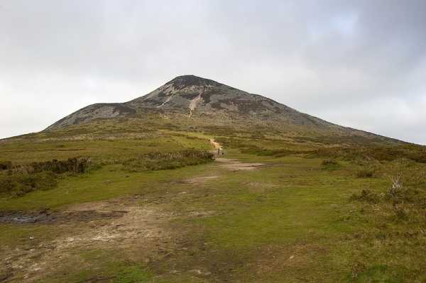
Picture: The Great Sugar Loaf from the South
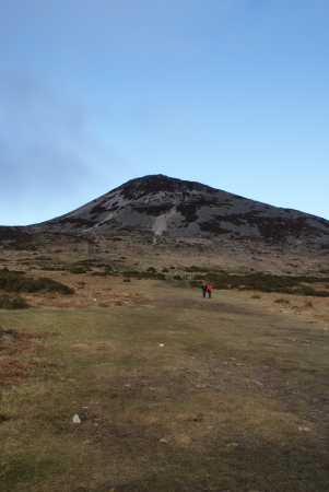
The Great Sugar Loaf is a very distinctive hill that towers above the small village of Kilmacanogue on the N11 Dublin – Wexford road. Conical and pointed, it is the volcano that never was. (Many people believe it is an extinct volcano but it is in fact Cambrian quartzite) But what is important is the fantastic shaped hill that is present now. It appears as a smaller version of Croagh Patrick.
Despite its rock-strewn steep upper slopes, the hill is easily climbed. (Although the final 30 metres ascent require care). The relatively easy ascent, combined with its close proximity to Dublin, means that the Great Sugar Loaf is climbed by thousands of people a year. It is surely one of the most famous hills in Ireland, and it even featured in the opening credits of TV soap Glenroe back in the day! The Sugar Loaf commands fine views, especially across the coast and even the mountains of Wales are easily visible to the naked eye on a clear day.
A car park at A (O235 119) will knock a couple of hundred metres off the ascent. A clear track leads up grassy slopes before contouring around the hill as it rises into the rocky upper slopes. The final rocky scramble might require steadying hands as you haul up a short steep gully. Car park to summit can be walked in about 45 mins on average.
Another route, with less usage, more climbing and more rugged quartzite slopes, starts from the small car park Fitzs GAA (O2436 1410) beside the Fitzsimons Park GAA ground which can be reached from Kilmacanogue and the N11.
Another places is from the free public car park in Kilmacanogue near Plucks (not Plucks own) at 1916 Mem (O24647 14626). You proceed west from here via the R755 and turn left at B (O24175 14695), initially up a concrete road and then onto open hillside.
You will probably meet dozens of folk out walking who haven’t climbed other hills, but for whom the Great Sugar Loaf is a must.
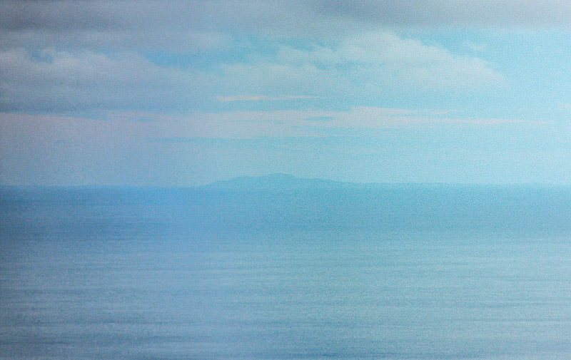
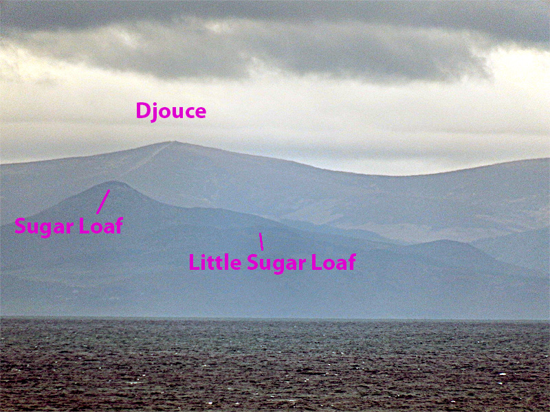
Occasionally, through the murky misty air above the Irish Sea there emerges a view of Wales in higher parts of Wicklow or the Dublin Mountains. And so it was on 26th December 2017 that this view of Snowdon 1085, appeared around 150km away.
Usually what you can see from this part of Wicklow is the distinctive shape of Yr Eifl (560m) which is on the Llyn Penisula and is a good bit nearer. Like Snowdon it appears as two summits, the rightmost being higher. However you can tell it apart from Snowdon because it appears steeper and the left peak Yr Eifl N has a visible vertical cliff to the left caused by quarrying. Had Yr Eifl been visible it would appear to the right of Snowdon.
Occasionally you hear that the track wear on Djouce is so bad that it can be seen from Wales. Maybe so, but then it is hard to see any part of Ireland from Wales.
I was curious therefore to look at this picture of Djouce from very roughly 10km out of Dublin port.
And yes the east track up Djouce is visible from here at least appearing as a lighter streak from the top towards the Sugar Loaf. Linkback: mountainviews.ie/summit/455/comment/19909/
Read Less
Read More
A scarred mountain
by paulocon
14 May 2012
Undoubtedly one of Ireland's Iconic mountains and one which always reminds me of Errigal. An impressive looking sight when driving down the N11. I had never climbed it so took advantage of a spare hour when driving down the country on a work-trip. Parked at the car-park on the Southern side of the mountain from which it's a relatively short walk along an obvious track which swings around and up the Western side of the mountain. Unfortunately, a low cloud cover meant that I didn't get to enjoy the views from the summit.
The mountain suffers from it's own popularity with the last section of the climb suffering badly from walker erosion. I'd venture a bet that it's one of Ireland's most climbed mountains. Linkback: mountainviews.ie/summit/455/comment/6800/
Read Less
Read More
Picture: Sugarloaf
Great Sugarloaf
by Dessie1
25 May 2010
Climbed Sugarloaf for the fifth time I think and it still has to be the coolest thing to do if you have a spare hour or so. Whether it is in snow or bathed in sunshine this little mountain really does give a great sense of fulfillment when summited.I have always gone for the direct approach from the southern side (small carpark just off L1031 I think) but will eventually try other routes when time is more abundant.Well worth a climb. Linkback: mountainviews.ie/summit/455/comment/4678/
Read Less
Read More
Picture: John (6) and Peter (4)
CaptainVertigo on Great Sugar Loaf
by CaptainVertigo
26 Mar 2005
This was always going to be a very difficult weekend for me, sandwiched between two delicious Navan Hillwalker's outings (Mournes last Sunday -Wicklow next). Poor concentration. Weight gain. Irritability. Loss of libido. Urgency. Frequency. Flatulence. Alopecia. All the usual symptoms. I needed a fix. But I couldn't simply hare off on my own up another great mountain. After all I'm joint head of the family (according to the Constitution). They are entitled to some meaningful contact. Hmmm. Then it came to me. Bring them too! At least all except the eldest who's away. Given that our youngest lads are aged 4 and 6 we needed a mountain that would be accessible and not overly challenging...but with worthy views at the summit. The answer was the Great Sugar Loaf. After a surprisingly easy trip from Meath via the M50 we arrived at the well trodden base. Model planes were buzzing about. Then we had to get past the motorcyclists (who seemed to be aged between 8 and 12). Peter (4) quickly tired on the lower slopes which was exactly what I had hoped for: I carried him up "piggy back" style, loving every moment of the suffering, my mind totally fixed on next week's Navan assault and the need for preparation. When we reached the shoulder we faced a tricky little scramble up a steep stoney path to the summit. I was thrilled when the two little lads insisted on attacking the route like a pair of mountain goats. God bless them...you could see the magnificent Vertigo genes vibrating in their little limbs!! How proud I was as they munched their sambos and slurped their soup at "the top of the world". Now in case you think we're not safety conscious I want to assure you that the little lads were carefully monitored by three "big people" at all times. A great outing. Okay it would have been better if the mountain had been slightly less busy than Grafton Street, and if I could have taken pot shots at the Model Planes and the mad cyclists...and if the mountain wasn't so damaged...but its handy, and its perfect for kids and the views are stunning. So...hey...you can't have it all!!
P.S. Mummy has pointed out that John is aged 6 not 7. I have corrected this error above. Also I have been asked to point out that John climbed the G.Sugar Loaf from base to summit and back without so much as an "are we there yet?" He is a true natural. PPS Mummy points out that the scramble just before the Sugar Loaf's summit could be dangerous. Linkback: mountainviews.ie/summit/455/comment/1588/
Use of MountainViews is governed by conditions and a privacy policy.
Read general information about the site. Opinions in material here are not necessarily endorsed by MountainViews.
Hillwalking is a risk sport. Information in comments, walks, shared GPS tracks or about starting places may
not be accurate for example as regards safety or access permission. You are responsible for your safety and your permission to walk.
See the credits and list definitions.


 Add a Place Comment for Great Sugar Loaf, Ó Cualann


 Our Facebook page.