This website uses cookies, which are small text files that the website puts on your device to facilitate operation. Cookies help us provide a better service to you. They are used to track general user traffic information and to help the website function properly.
MountainViews is standardising on this new presentation style for the "Main Page". For a short while it is still possible to
Get the equivalent "old" page here. Or choose from the "Home" menu option above to change.
Feature count in area: 38, all in Donegal,
OSI/LPS Maps: 1, 11, 2, 6
Highest Place: Errigal 751m
Starting Places (29) in area Derryveagh Mountains: Aleahan Lough, Altderry Bridge, An Chúirt Hotel, Astelleen Burn Waterfall, Derryreel Lough, Dunlewy Lough E, Dunlewy Lough Viewing Point, Errigal Hostel, Errigal Parking, Glenveagh Bridge, Glenveagh National Park SW, Glenveigh Castle, Keel Lough N, Losset North, Lough Acrobane Farmhouse, Lough Ascardan, Lough Barra Slipway CP, Lough Barra W, Meenagoppoge Burn Bridge, Mín Uí Bhaoil, Muckish Gap Shrine, Muckish North Access Road, Nabrackbaddy Lough, Procklis Lough, River Barra Bridge NE, River Barra Bridge SW, Sand Lough NE, Sruhancrolee Bridge, Stranamarragh Bridge
Summits & other features in area Derryveagh Mountains: Cen: Dooish: Dooish 651.5m, Dooish SW Top 528m, Dooish SE Top 553.9m, Saggartnadooish 506.4m, Saggartnadooish East Top 478.9m Cen: Errigal: Errigal 751m, Mackoght 555m Cen: Glenveagh Upper: Crockfadda 485m, Crockfadda East Top 454m, Crockballaghgeeha 480m, Crockmulroney 430m, Staghall Mountain 486m, Croaghnasaggart 480m, Maumlack 480m Cen: Lough Keel (Meencorwick): Crockglass 489m, Addernymore 416m, Grogan More 457m, Crocknafarragh 517m, Crocknafarragh SE Top 470m Cen: Slieve Snaght: Crockfadda 529m, Crockfadda NE Top 502m, Crocknasharragh 495m, Drumnalifferny Far NE Top 535m, Bingorms 578m, Drumnalifferny Mountain 596m, Drumnalifferny Mountain NE Top 585m, Slieve Snaght 678m N: Aghla: Aghla Beg 563.9m, Aghla Beg South Top 602.3m, Aghla More 581.2m, Ardloughnabrackbaddy 472.5m, Crocknalaragagh 470.6m N: Muckish: Muckish 667.1m, Croaghaderry 222m, Crockawama 238m, Derryreel 232m S: Doochary: Croaghleconnell 266m S: Dungloe: Crovehy 315m
Note: this list of places may include island features such as summits, but not
islands as such.
Crockfadda NE Top, 502mMountain An Cnoc Fada (mullach thoir thuaidh) A name in Irish,
Place Rating ..
For origin of name, see An Cnoc Fada / Crockfadda., Donegal County in Ulster province, in Arderin Lists, An Cnoc Fada (mullach thoir thuaidh) is the 568th highest place in Ireland.
Grid Reference B91588 14409,
Mapsheet(s): 1 Place visited by: 90members, recently by: Lyner, markwallace, Claybird007, jellybean, Nomad691, Krumel, davidrenshaw, Carolineswalsh, NualaB, nupat, paulbrown, Seamy13, TessDws, Cecil1976, annem
I visited this place: NO (You need to be a logged-in member for this.)
Short or GPS IDs, 6 char: CrckNE, 10 char: CrckfdNETp Linkback: https://mountainviews.ie/summit/449/
Gallery for Crockfadda NE Top (An Cnoc Fada (mullach thoir thuaidh)) and surrounds
Summary
for Crockfadda NE Top (An Cnoc Fada (mullach thoir thuaidh)):
Worth the climb.
Summary created by Harry Goodman
15 Aug, 2012
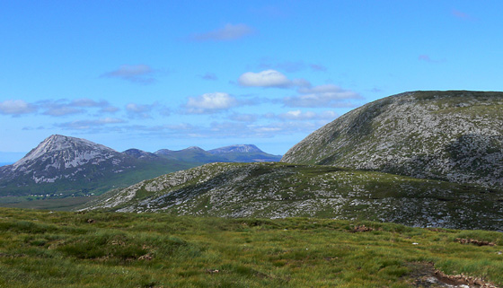
Picture: Crockfadda NE Top from Crockfadda with Slieve Snaght beyond.
Park off road at Sruhcrol (B93314 12721) just S of a bridge over the Sruhancrolee stream. With the stream on the right follow it up NW over rough and marshy ground and after 1.5k go up steeply beside a small waterfall. as the ground becomes less steep continue to follow the line of the stream NW and then N to a boggy saddle between Slieve Snaght and Crockfadda NE Top A (B918 145). Go SW (left) up the slope to gain the broad flat top with the high point marked by a substantial cairn. Return by way of ascent. This route can also be used as access to the first top in a looped walk that would also include Crockfadda and Crocknasharragh.
Add a Place Comment for Crockfadda NE Top, An Cnoc Fada (mullach thoir thuaidh) (449) in Area: Derryveagh Mountains, Cen: Slieve Snaght, County: Donegal, Cen: Slieve Snaght
Crockfadda North-East Top in the foreground with Crockfadda behind on the left. On the right is the isolated Lough Agannive and on the extreme right is the corner of Lough Atirrive.In the distance behind Crockfadda is Crocknasharragh at 495 mtrs just missing the 500 mtr list. The vantage point for the photo is on the side of Slieve Snaght. After descending from Crockfadda North-East Top we paused for a while wondering what was the best way to climb Slieve Snaght fromm this side as at first glance it seemed quite steep. Spurred on by the gung-ho approach of one of the party we went straight up a grassy, midge-infested gully at approx. B (B921 143). This turned out to be easier going than expected although we exited the gully before the top as it was becoming quite steep.Once out of the gully the slope began to level off as we neared the summit cairn. We descended the steep boggy slope to Loch Sliabh Sneachta , a scenic little lake with much evidance of glacial erosion before striking out for Drumnaliffern and Bingorms. Linkback: mountainviews.ie/summit/449/comment/1955/
Read Less
Read More
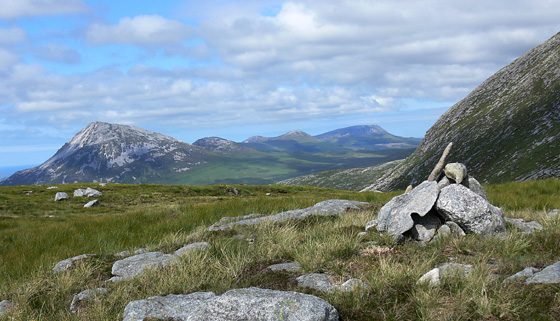
Picture: Errigal, beyond the slopes of Slieve Snaght
Easy Bag
by Aidy
9 Apr 2016
After making it down through the boulders on Slieve Snaght's western side, it was a short easy walk up to the cairn marking the top of this summit. An easy bag on the way to Crockfadda itself, and good views back to Slieve Snaght and beyond to Errigal. Linkback: mountainviews.ie/summit/449/comment/18487/
Read Less
Read More
Picture: Murky coast.
simon3 on Crockfadda NE Top
by simon3
17 Sep 2005
This is a low ridge of a summit, just reaching the 500m mark. It is very much overshadowed by its eastern neighbour Sleve Snaght (right of picture) and even by Crockfadda to its west.
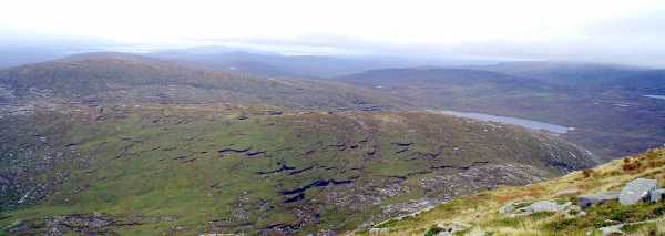
The murky view to the north includes the extensive beach north of Falcarragh 20k away and the scree slopes on the side of Slieve Snaght.
Unimpressive it may seem but views make it worthwhile.
by Harry Goodman
11 Aug 2012
My approach to this top on 26 July 2012 was up from the boggy saddle to the W of Slieve Snaght A (B918 145). This was the fourth hill in a round which had started from the R254 and up over Bingorms. (For the previous part of my route see my comments on Slieve Snaght.) Viewed from the heights of Slieve Snaght this is an unimpressive top appearing, as it does, as a ridge to be crossed on the way to Crockfadda. The ground up was in the main trackless but soon led to a broad flat top with the high point marked by a substantial cairn. While views E were completely blocked by the bulk of Slieve Snaght those to the N from Errigal along to Muckish were impressive and to the S was the long line of the Bluestacks. Although this is a mountain that is unlikely to be sought out and climbed in it's own right it is certainly worth including in a round with other tops. From the high point I continued down SW to yet another saddle C (B913 140) on the way to my next summit, Crockfadda. Linkback: mountainviews.ie/summit/449/comment/14745/
Read Less
Read More
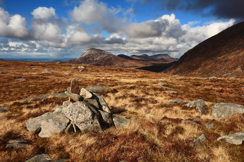
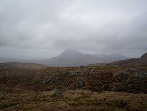
Picture: Looking across Crockfadda North-East Top towards Errigal
eflanaga on Crockfadda NE Top
by eflanaga
20 Apr 2006
(Climbed April 17th – see Slieve Snaght for previous stage in walk). The descent from Slieve Snaght via its boulder-strewn western slope to the narrow col between it and Crockfadda N-E Top is an extremely steep 220m and is not for the faint-hearted. Wiser people might decide to endure some extra walking by descending Snaght’s southern slope with its steady gradient before turning north and climbing back up to the col. Since the weather was threatening to deteriorate, I decided to take the steeper option. With due care the descent proved quite manageable but I was glad to reach the relative flatness of the col just south of a small locheen (D (B91827 14632)). From here it is a short and easy climb up onto the summit. The top has nothing particularly noteworthy to offer, cowering as it does beneath Slieve Snaght’s brooding presence. Therefore, I did not delay making straight for Crockfadda (the final target in this five summit horseshoe walk). (Picture is taken on way to Crockfadda looking back over the N-E Top towards Errigal in the distant gloom). Linkback: mountainviews.ie/summit/449/comment/2287/
Use of MountainViews is governed by conditions and a privacy policy.
Read general information about the site. Opinions in material here are not necessarily endorsed by MountainViews.
Hillwalking is a risk sport. Information in comments, walks, shared GPS tracks or about starting places may
not be accurate for example as regards safety or access permission. You are responsible for your safety and your permission to walk.
See the credits and list definitions.


 by miriam Click for player.")
 by patrickzerkowski Click for player.")
 by mcrtchly Click for player.")
 by gerrym Click for player.")

 Add a Place Comment for Crockfadda NE Top, An Cnoc Fada (mullach thoir thuaidh)


 Our Facebook page.