Cookies.
This website uses cookies, which are small text files that the website puts on your device to facilitate operation. Cookies help us provide a better service to you. They are used to track general user traffic information and to help the website function properly.
Features
Nearby features appear when you click the map.
Declutter tracks on map.
Place Search
Video
X
Pub: by
South East Midlands Area , SE: Brandon Hill Subarea
Feature count in area: 31, by county: Laois: 6, Carlow: 1, Offaly: 1, Kildare: 2, Kilkenny: 13, Tipperary: 8, OSI/LPS Maps: 28A, 28B, 47, 48, 49, 53, 54, 55, 59, 60
Highest Place: Slievenamon 720.2m

Starting Places (16) in area South East Midlands:
Ballinvarry West, Clodiagh Church, Coolnahau, Coppanagh Wood South, Freney's Well, Glynn, Gorlough Wood, Hill of Allen, Inistioge, Killamery Wood East, Kylebeg Wood, Lingaun River, Mount Alto Wood, Mullenbeg Wood South, Newtown Upper School, Slievenamon Walk Head

Summits & other features in area South East Midlands:
E: Barrow: Clogrennan Hill 336m, Newtown Hill 208m
N Cen: Timahoe Hills: Ballaghmore Hill 268m, Cullenagh Mountain 317m, Fossy Mountain 332m, Hewson Hill 261m
N: Croghan: Croghan Hill 234m
N: Newbridge Hills: Dunmurry Hill 233m, Hill of Allen 219m
S: Mullinavat: Coolnahau Hill 265m, Corbally Hill 285m, Mount Alto 276m, Tory Hill 292m
S: Slievenamon: Knockahunna 502.8m, Sheegouna 553.5m, Slievenamon 720.2m, Slievenamon North-West Top 564m
S: Windgap: Carricktriss Gorse 314m, Carrigadoon Hill 296.9m, Faranaree Hill 283m
SE: Brandon Hill: Brandon Hill 515m, Coppanagh 365m, Croghan 365m
W Cen: Durrow: Ballynalacken Hill 314m, Caponellan Hill 253m, Knockmannon Hill 315m
W Cen: Slieveardagh: Clomantagh Hill 349m, Knocknamuck 340m, Monabrogue 284m
W: Horse & Jockey: Kill Hill 241m, Killough 235m

Note: this list of places may include island features such as summits, but not islands as such.
Rating graphic.
Brandon Hill, 515m Mountain Cnoc Bhréanail A name in Irish,
Place Rating ..
(Ir. Cnoc Bhréanail [OSI], 'hill of Bréanal'), Cnoc Bhréannann County Highpoint of Kilkenny in Leinster province, in County Highpoint, Arderin Lists, Brandon Hill is the 523rd highest place in Ireland. Brandon Hill is the highest point in county Kilkenny.
Grid Reference S69702 40268, OS 1:50k mapsheet 68
Place visited by: 449 members, recently by: AnthonyJ, DarrenY, Petecal423, RosieMc, Leatra, farmerjoe1, ccartwright, Deirdreb, Muscles1960, GerryAlex, eimirmaguire, rhw, purpleknight, discovering_dann, Magic
I visited this place: NO (You need to be a logged-in member for this.)
Longitude: -6.974129, Latitude: 52.509839, Easting: 269702, Northing: 140268, Prominence: 450m,  Isolation: 5.6km, Has trig pillar
ITM: 669638 640323
Bedrock type: Rhyolitic volcanics, grey & brown slates, (Campile Formation)
Notes on name: This is the highest point in Co. Kilkenny. Brandonhill is also the name of a townland split between the parishes of Graiguenamanagh and The Rower and between the baronies of Gowran and Ida. There is also a townland named Brandondale in the parish of Graiguenamanagh.
  Short or GPS IDs, 6 char: BrndHl, 10 char: BrndnHil

Linkback: https://mountainviews.ie/summit/423/
Gallery for Brandon Hill (Cnoc Bhréanail) and surrounds
Summary for Brandon Hill (Cnoc Bhréanail): The 360 degree panorama is worth coming to see
Summary created by jackill 30 Jul, 2012
            MountainViews.ie picture about Brandon Hill (Cnoc Bhréanail)
Picture: Looking to the Blackstairs
Turn off the main road at A (S67766 42279), taking care when near this point as its easy to miss the turn off.
The forest entrance, Gorlough (S68218 41485), can be locked so you may need to park(space for 2 cars) and walk. At B (S68848 40961) cross a stile to your right and follow a rough track next to a stone wall uphill.At C (S69243 40632) turn right up the track to the summit.
The summit has a large rusting metal cross from 1984, a cairn, a hut and a pillar that locates and names features visible on the surrounding landscape.
Linkback: mountainviews.ie/summit/423/comment/5182/
Member Comments for Brandon Hill (Cnoc Bhréanail)

            MountainViews.ie picture about Brandon Hill (Cnoc Bhréanail)
Picture: Summit, trig pillar and blockhouse.
simon3 on Brandon Hill
by simon3 24 Sep 2005
According to PW Joyce [Irish Local Names Explained] Brandon Hill is named after St Brendan the Navigator. It is an isolated peak around 12k SE of the Blackstairs. Like the Blackstairs it is mainly made of granite. Like other isolated peaks, the views from Brandon hill are well known for quality, so good in fact that someone has put a direction indicator near the summit. To the NE are the Coppanagh Hills (365m) reputedly interesting for a short walk, though from the map it would appear that the trig pillar on Coppanagh is now in a wood.
The photo shows a night view of the cairn on the summit with its trig pillar, taken from near the direction indicator. The night was relatively clear and on the original picture there are various astronomical objects clearly visible. The square outline on the left is a concrete block house. Paul Clements [The Height of Nonsense] suggests sort of eponymously that "It's the Temple of Zodiac .. It's where you meet old friends before you come to the World's End down there at Nova Villa Pontis" (This was part of the name of a bridge in Newross built in the 12th century. No, no, I don't understand the allusion either.)

A more prosaic suggestion is that the 13m cross on the summit had lights which in turn needed power, a generator and housing. Linkback: mountainviews.ie/summit/423/comment/764/
Read Less
Read More

            MountainViews.ie picture about Brandon Hill (Cnoc Bhréanail)
Picture: The view towards Mt Leinster and Blackstairs Mtn, from Brandon Hill
csd on Brandon Hill
by csd 9 Jul 2006
I elected to tackle Brandon Hill from the south. Leaving the R705, I turned right onto the laneway at D (S718 379), a location marked on sheet 68 as Ballinvary Irish. It's quite easy to miss this, so keep a look out for a small lane that almost doubles back on itself as you turn off the main road. Follow this track (not recommended for low-slung vehicles!) to the forest gate at Bl'Varry (S710 379), where there's space for one or two cars to park. I then followed the forest tracks (accurately shown on sheet 68) to approach the summit from the south. You pick up some markers labelled "BW" (Brandon Way?) as you make your way through the forest; these will accompany you all the way to the summit. Views from the top are excellent; although not the highest of peaks, its relatively isolated position commands a stunning panorama. Linkback: mountainviews.ie/summit/423/comment/2422/
Read Less
Read More

            MountainViews.ie picture about Brandon Hill (Cnoc Bhréanail)
Picture: Graiguenamagh from near the summit
Brandon
by Geansai 10 Apr 2011
Approaching Graiguenamanagh by car from the east going across the bridge through the narrow streets and on to a big car park on the right before the roundabout. Walked up to the roundabout from the car park and turned left as per the sign for Inistogue. Turned right at the top of the hill and immediately left and its straight up all the way. Follow the sign marked by a cross when you get to a junction well above the last houses, ie: straight ahead. Took me an hour and three quarters to walk to the top of Brandon from the centre of Graiguenamanagh but I was pushing it. Great views. You can see a town towards the south.probably New Ross. It was a beautiful day. Linkback: mountainviews.ie/summit/423/comment/6299/
Read Less
Read More

Big-Foot on Brandon Hill
by Big-Foot 29 Dec 2008
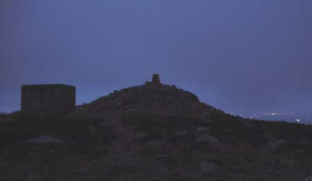
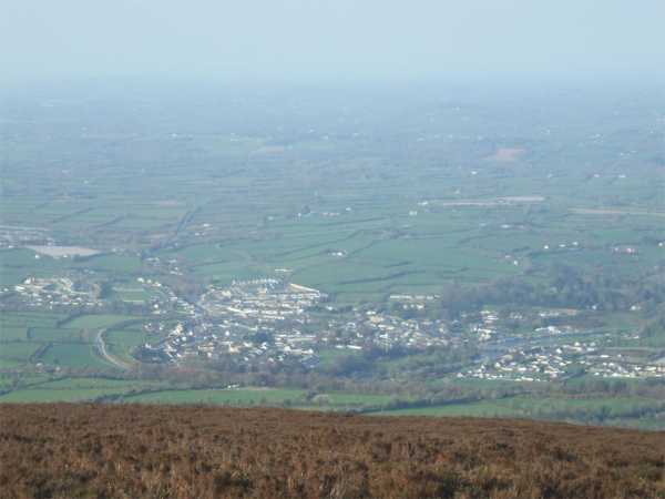
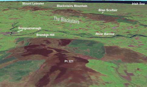
I walked to the top of Brandon Hill today, from the northern side.
Total height gain is about 380m, so it was not a very challanging walk, but worth the views from the summit.
Here is a detailed GPS route to the top.
I drove west out of Graiguenamanagh, towards Inistigue. Parked on the side of the road at IE (S67754 42269) where the road was wide enought to safely park up. Walked from here up a dirt track (suitable for cars during dry weather) to IF (S68849 40978). Here you have a choice; continue on this wide route, or turn south to climb up quicker on a much rougher track. I decided stay on the wide track for the asent and to come back by this steeper way. Continuted on south east to IG (S69088 40734), north east to I Freny (S69916 41148), west for 50m then south to IH (S69897 41021). Following the track west for 800m to II (S69247 40634), then turned north for last 120m climb to summit, at IJ (S69700 40271).
Descented back to II (S69247 40634), then turned west to IK (S68851 40737), and finally north to IF (S68849 40978). Walked back to car, 1.7km down dirt track.
Overall walk is about 8.5km long, and should take just over 1.5 hours. Linkback: mountainviews.ie/summit/423/comment/3490/
Read Less
Read More

            MountainViews.ie picture about Brandon Hill (Cnoc Bhréanail)
simon3 on Brandon Hill
by simon3 20 Sep 2004
This visualisation looks broadly north east and shows how Brandon Hill is a good place to see the whole of the ridge of the Blackstairs some 10 km away. Data from NASA and dated 2000. Linkback: mountainviews.ie/summit/423/comment/1188/
Read Less
Read More
EDIT Point of Interest
text
Videos
Users Online

Guests online: 230
Recent Contributions
x
Conditions and Info
Use of MountainViews is governed by conditions and a privacy policy.
Read general information about the site.
Opinions in material here are not necessarily endorsed by MountainViews.
Hillwalking is a risk sport. Information in comments, walks, shared GPS tracks or about starting places may not be accurate for example as regards safety or access permission. You are responsible for your safety and your permission to walk.
See the credits and list definitions.

OSi logo
OSNI/LPS logo
Open Street Map
(Various variations used.)
British summit data courtesy:
Database of British & Irish Hills