This website uses cookies, which are small text files that the website puts on your device to facilitate operation. Cookies help us provide a better service to you. They are used to track general user traffic information and to help the website function properly.
Feature count in area: 115, by county: Wicklow: 108, Kildare: 4, Wexford: 2, Carlow: 3, of which 1 is in both Wexford and Wicklow, of which 1 is in both Carlow and Wicklow,
OSI/LPS Maps: 28B, 55, 56, 61, 62, AWW, EW-DM, EW-LG, EW-WE, EW-WS
Highest Place: Lugnaquilla 924.7m
Starting Places (205) in area Wicklow: 1916 Memorial Car Park, Aghavannagh Ow Bridge, Aghowle Wood, Altidore Wood Entrance, Annacurra National School, Annalecka Bridge, Asbawn Brook L8350, Aughrim National School, Ballard Road, Ballinabarny Gap, Ballinagappoge Bridge Layby, Ballinagappoge Mountain Hairpin, Ballinagore, Ballinahinch Wood, Ballinastoe MBT CP, Ballinastraw South, Ballineddan Upr Fork, Ballinfoyle Upr Cross, Ballycoog, Ballycreen Brook Bridge, Ballycumber, Ballycumber Bridge, Ballycumber Lane, Ballycumber Wicklow Way, Ballylerane, Ballylow Bridge, Ballylusk Quarry, Ballymanus Lane, Ballymoyle Shooting Lodge, Ballynultagh Gap, Ballynultagh Lane, Ballyreagh Wood, Ballyross Forest, Ballysmuttan Long Stone, Baravore, Barnbawn South, Barranisky North, Barranisky West, Bohilla Land Roundabout, Bohilla Lane Mid, Boranaraltry Bridge, Bray Harbour, Brewel West, Brittas Bay North CP, Buckroney Sand Dunes CP, Bus Terminus, Camera Hill Track Cross, Castletimon Wood North, Clara Vale, Clone House Road, Clonegal, Cloon Wood Cp, Coate Bridge, Coolballintaggart Ledge, Coolbawn House Lane, Cransillagh Brook , Crone Wood CP, Crossbridge, Crossoona Rath, Cummer Wood South, Curtlestown Wood CP, Deputy's Pass CP, Derralossary Church, Derry River Bridge, Devil's Glen CP, Devil's Glen Wood, Djouce Wood Calary, Djouce Wood Lake, Djouce Wood Long Hill, Donard, Donnelly's Lane Car Sales, Drumgoff Forest, Dunranhill North, Dunranhill SE, Dunranhill South, Dwyer McAllister Cottage CP, Enniskerry, Fentons Pub, Fitzsimons Park GAA, unuseableFlemings Footbridge Glen Rd, Gap Pub, Gap Road, Glen Beach CP, Glen of the Downs CP, Glenbride Lane, Glenbride Lodge, Glencree Reconciliation, Glendalough, Glenealy GAA, Glenmacnass Tonelagee CP, Glenmalure Hostel, Glenmalure Lodge, Glenmalure Waterfall, Glenview Hotel, Gowle House, Great Sugar Loaf CP, Grove Bar, Heffernans Well Wood, Hill View, Hollywood Glen, JB Malone CP, Johnnie Fox Pub, Keadeen NE trail, Keadeen Trailhead, Kevins Way Footbridge, Kilbride Army Camp Entrance, Kilcandra South, Kilcommon View, Killalongford Wood, Kilmacrea Cross Roads, Kilranelagh House Gate, Kilruddery Car Park, Kilruddery Cottages, Kings River, Kippure Bridge, Kippure Estate, Kippure Transmitter Gate, Knickeen Cross, Knocknaboley Lane Leeraghs Bog, Knocknaboley Lane Stone Cottage, Knockrath Little, Knockree west, Kyle Loop North, Lackan Wood S, Lake Dr Fraughan Brook, Lake Drive, Lake Park Cross, Lake View Pub, Laragh Free Car Park, Laragh NSch, Lead Mines CP, Liffey Bridge, Liffey Head Bridge, Lough Bray Lower, Lough Bray Upper, Lough Tay North Viewing Point, Lough Tay Wicklow Way CP, Luglass Lane L97561, Lugnagun Track, Macreddin Village, Mangans Lane, Military Road Carrigshouk Hill, Military Road Inchavore River Nth, Military Road Inchavore River Sth, Military Road NW Lough Tay, Military Road Ballyboy Bridge, Military Road Cloghoge Brook, Military Road Croaghanmoira, Military Road Fananierin, Military Road LaraghWicklow Way, Military Road Slieve Maan, Monspolien Bridge, Moortown House, Mountain Rescue HQ, Muskeagh Little Wood, Nahanagan Lough NE, Novara Avenue, Bray, Oiltiagh Brook Knickeen, Old Bridge Cross, Old Bridge Scouts , Old Wicklow Way entrance, Paddock Hill SE, Pier Gates CP, Powerscourt Waterfall CP, Putland Road, Quintagh East, Raheen Park CP, Raheenleagh East, Railway Walk CP, Rathdrum Railway Station, Rednagh Wood, Rocky Valley, Roundwood, Sally Gap, Sally Gap N, Seefin Trailhead, Seskin SE, Shankill Tributary Bridge, Shay Elliott, Sheepshanks Bridge, Shillelagh, Slievecorragh Track, Slievefoore South, Sraghoe Brook, St John's Church, St Kevins Chair, St Kevins Church, St Kevins Way R756, Stone Circle Bridge, Stookeen South, Stranahely Wood, Stranakelly Cross Roads, Tallyho, Templeboden, Tithewer, Tomcoyle L, Tomriland Wood, Toor Brook, Trooperstown Hill Access, Turlough Hill CP, Upper Lake CP, Vallymount GAA CP, Vartry Reservoir Upper, Zellers Pub
Summits & other features in area Wicklow: Cen: Glendalough North: Brockagh Mountain 556.9m, Brockagh Mountain NW Top 549.5m, Brockagh Mountain SE Top 471.7m, Camaderry East Top 677.3m, Camaderry Mountain 698.6m, Conavalla 734m, Tomaneena 682.4m Cen: Glendalough South: Carriglineen Mountain 456.6m, Cullentragh Mountain 510m, Derrybawn Mountain 476.1m, Kirikee Mountain 474.5m, Lugduff 653.2m, Lugduff SE Top 638m, Mullacor 660.7m, Trooperstown Hill 430m N Cen: Tonelagee: Carrignagunneen 561m, Fair Mountain 571.2m, Stoney Top 713.7m, Tonelagee 815.8m, Tonelagee E Top 668m, Tonelagee South-East Top 545.8m NE: Bray & Kilmacanogue: Bray Head Hill 238.9m, Carrigoona Commons East 242m, Downs Hill 372.9m, Great Sugar Loaf 501.2m, Little Sugar Loaf 342.4m NE: Djouce: Djouce 725.5m, Knockree 342.1m, Maulin 570m, Tonduff 642m, Tonduff East Top 593m, War Hill 684.8m, White Hill 631.1m NE: Fancy: Ballinafunshoge 480m, Kanturk 527.4m, Knocknacloghoge 532.4m, Luggala 593.3m, Robber's Pass Hill 508.9m, Scarr 640m, Scarr North-West Top 559.8m, Sleamaine 430m NE: Vartry: Ballinacorbeg 336m, Ballycurry 301m, Dunranhill 342m, Mount Kennedy 365.9m NW: Blessington: Carrigleitrim 408m, Lugnagun 446.2m, Slieveroe 332m, Sorrel Hill 599.5m NW: Mullaghcleevaun: Black Hill 602.2m, Carrigshouk 572.5m, Carrigvore 682.4m, Duff Hill 720.8m, Gravale 719m, Moanbane 703m, Mullaghcleevaun 846.7m, Mullaghcleevaun East Top 796m, Silsean 698m S: Aughrim Hills: Cushbawn 400m, Killeagh 249m, Moneyteige North 427m, Preban Hill 389m S: Croaghanmoira: Ballinacor Mountain 529.3m, Ballycurragh Hill 536m, Ballyteige 447m, Carrickashane Mountain 508m, Croaghanmoira 662.3m, Croaghanmoira North Top 579.5m, Fananierin 426m, Slieve Maan 547.8m, Slieve Maan North Top 546.1m S: Croghan Kinsella: Annagh Hill 454m, Croghan Kinsella 606m, Croghan Kinsella East Top 562.1m, Slievefoore 414m S: Shillelagh Hills: Lakeen 357m, Monaughrim 206m, Seskin 344m, Stookeen 420m S: Tinahely Hills: Ballycumber Hill 429.7m, Eagle Hill 296m, Muskeagh Hill 398.2m SE: Wicklow South East: Ballinastraw 284m, Ballyguile Hill 188m, Barranisky 280m, Carrick Mountain 381m, Collon Hill 238m, Kilnamanagh Hill 217m, Westaston Hill 270m W: Baltinglass: Ballyhook Hill 288m, Baltinglass Hill 382m, Carrig Mountain 571m, Carrigeen Hill 298m, Cloghnagaune 385m, Corballis Hill 258m, Keadeen Mountain 653m, Spinans Hill 409m, Spinans Hill SE Top 400m, Tinoran Hill 312m W: Cen Lugnaquilla: Ballineddan Mountain 652.3m, Benleagh 689m, Camenabologue 758m, Camenabologue SE Top 663m, Cloghernagh 800m, Corrigasleggaun 794.6m, Lugnaquilla 924.7m, Slievemaan 759.7m W: Donard: Brewel Hill 222m, Church Mountain 544m, Corriebracks 531m, Lobawn 636m, Slievecorragh 418m, Sugarloaf 552m, Table Mountain 701.7m, Table Mountain West Top 563m
Note: this list of places may include island features such as summits, but not
islands as such.
Cloghernagh, 800.0mMountain Clocharnach A name in Irish,
Place Rating ..
(Ir. Clocharnach [PNCW], 'stony place'), Leohard, Wicklow County in Leinster province, in Arderin Beg, Vandeleur-Lynam Lists, Cloghernagh is the 41st highest place in Ireland.
Grid Reference T05740 91896,
OS 1:50k mapsheet 56 Place visited by: 653members, recently by: emermcloughlin, David.Smyth, rhw, MartMc, Courin, maoris, davidrenshaw, Prem, Carolineswalsh, NualaB, ToughSoles, muddypaws, FoxyxxxLoxy, SeanPurcell, Magic
I visited this place: NO (You need to be a logged-in member for this.)
Short or GPS IDs, 6 char: Clghrn, 10 char: Clghrngh Linkback: https://mountainviews.ie/summit/40/
Gallery for Cloghernagh (Clocharnach) and surrounds
Summary
for Cloghernagh (Clocharnach):
Summary
Summary created by Trailtrekker, Dessie1
2014-04-21 20:46:45
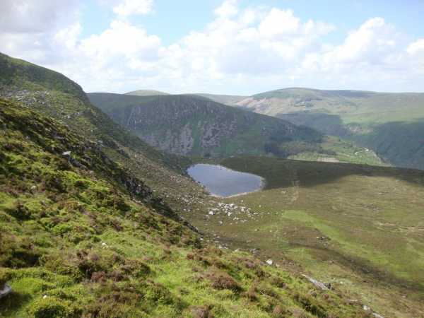
The quickest and easiest way to add Cloghernagh to your summit list is to start at the (Flem FB (T08755 92136))Bridge which crosses the Avonbeg river at the base of the Zigzags(Go around the farmyard at the start and not through it!).A boggy easily identifiable track leads all the way to the 800m summit (Cairn at A (T058 918)).Breathtaking views of Benleagh and Fraughen Rock Glen can be seen from the steep face to the north.
It can also be taken on the descent or ascent of Lugnaquilla. From Lugnaquilla head north east taking a route near the south prison, before turning east and taking a gentle ascent on a clearly worn path to the summit.
The route from the Fraughan Rock Glen starts by fording the river near a track junction at B (T05851 93923), head 150 yards west to exit through a gate before doubling back to make the steepish and boggy ascent along a fence and forestry to reach Arts Lough. Continue along the boggy but distinct track until it rises up a ramp that leads over the top edge of the cliffs. At about point C (T06195 92331) take a south westerly route to the summit.
Picture: Arts Lough with the track also clearly visible
Arts Lough Loop
by darrenf
7 Aug 2010
Parked up at the carpark next the footbridge at Baravore B'vore (T066 942). Crossed the Avonbeg River via the footbridge. Contuined along the gravel track which leads up to the an oige youth hostel and shortly afterwards we took the track which bears left (contuining on the original track will take you further into the Glenmalur valley). Followed this forest track right around into Fraughan Glen where the views really open out in front of you. The entire track is not clearly identified on Sheet 56 but it will take you deep into the glen and only really peters out at the back wall of the glen - at this point another faint track can be picked up which stays to the right hand side of the benleagh river and continues up and over Fraughan Glen. Spectacular views back down the glen and across to Lugduff can be enjoyed.
Once on top of the glen you wil notice a fairly obvious and steep looking 'grassy ramp' to your left hand side at roughly D (T044 928). Taking a route directly up the ramp will being you to the ridge (marked as the Ballinaskea area on the map) which leads across to the cliffs overlooking Arts Lough. A well deserved lunch break can be enjoyed here while savourying the spectacular views before you. From this point a faint but easily identifed track emerges which will take you directly to the summit of Cloghernagh. From the summit if you take a route toward E (T061 924) you will discover another track which will take you safely down to the shore of Arts Lough. Well worth taking another short break!! Further obvious tracks emerge which descend along the forest edge and take you back onto the gravel track leading into Fraughan Glen. Simply retrace your steps back to the car at Baravore. A very enjoyable walk. Linkback: mountainviews.ie/summit/40/comment/5988/
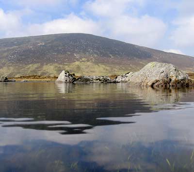
Cloghernagh from the other side! Park at Dromgoff barracks and follow the Wicklow Way signs into the forest on the right. Use the Healy Glendalough/Glenmalure map to head for Kelly's Lough. This makes a nice spot for lunch. You can then head up Cloghernagh and come down on the Glenmalure road, or else head east over Carrawaystick Mountain and follow the tracks back down to Drumgoff barracks. Picture shows Kelly's Lough, with the spur of Carrawaystick heading towards Lugnaquilla in the background. Linkback: mountainviews.ie/summit/40/comment/427/
Read Less
Read More
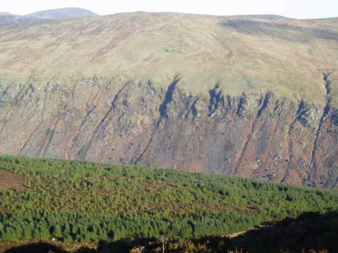
Picture: Serrated Northern Side of Glenmalure
mneary34 on Cloghernagh
by mneary34
15 Jan 2006
On an early January morning I headed for Lug going via Clohernagh having parked the car at the main car park beside the river crossing near the An Oige Hostel in Glenmalure. My route was along forest tracks past the Hostel and then for the base of the Fraughan Rock Glen at a point F (T054 938). From that point there's a route beside the forest edge with a climb of 200 metres to Art's Lough. Going past the lough on its northern side approximately 300 metres further south east there is a path which leads not too steeply in a southerly direction eventually towards the summit of Clohernagh which is 300 metres above Art's Lough. Any route directly up from the lough should be avoided as it will include very steep ground. I took GPS readings on the summit and while I agree exactly with the grid ref. given for Clohernagh at G (T057 919) the cairn is actually at A (T058 918). On the way to the summit great views open to the north and the attached photo shows how the northern side of Glenmalure which looks so big from the valley floor reduces in scale from near the top of Clohernagh. To appreciate the scale of Glenmalure the green area in the foreground looks almost like grass but is forest. Linkback: mountainviews.ie/summit/40/comment/2145/
Read Less
Read More
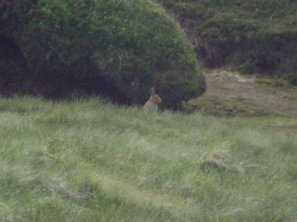
No deer but...
by darrenf
7 Aug 2010
In Wicklow it would be uncommon not to spot a deer on almost every major mountain walk but I never came across a wild mountain hare until Cloghernagh. He might not be very clear in the photo but this little fella almost 'followed' me for some time and was by no means shy!! Linkback: mountainviews.ie/summit/40/comment/5989/
Use of MountainViews is governed by conditions and a privacy policy.
Read general information about the site. Opinions in material here are not necessarily endorsed by MountainViews.
Hillwalking is a risk sport. Information in comments, walks, shared GPS tracks or about starting places may
not be accurate for example as regards safety or access permission. You are responsible for your safety and your permission to walk.
See the credits and list definitions.


 Our Facebook page.