Cookies.
This website uses cookies, which are small text files that the website puts on your device to facilitate operation. Cookies help us provide a better service to you. They are used to track general user traffic information and to help the website function properly.
Features
Nearby features appear when you click the map.
Declutter tracks on map.
Place Search
Video
X
Pub: by
Sperrin Mountains Area , E: Magherafelt Hills Subarea
Feature count in area: 64, by county: Derry: 34, Tyrone: 39, of which 9 are in both Derry and Tyrone, OSI/LPS Maps: 12, 13, 6, 7, 8
Highest Place: Sawel 678m

Starting Places (21) in area Sperrin Mountains:
Altinure Road, Banagher Glen Nature Reserve, Barnes Gap Car Park, Crocknakin, Drumnaspar Picnic CP, Glenchiel Road, Glenedra Bridge, Glenelly Road, Parkreagh, Goles Road, Lough Ouske, Moneyneany Village, Moydamlaght Forest, Moydamlaght Road, Mullaghmore, Mullaghbane, Spaltindoagh, Sperrin Hamlet, Sperrin Heritage Centre, Sperrin Heritage Centre W, Sperrin Road, Barnes Top, Sperrin Road, Glashagh Bridge, Sperrin Road, Sperrin

Summits & other features in area Sperrin Mountains:
E: Magherafelt Hills: Slieve Gallion NE Top 493.6m
E: Magherafelt Hills: Slieve Gallion 526.6m
N: Claudy Hills: Crockdooish 321m, Curradrolan Hill 270m, Eglish 277m, Letterlogher 249m, Mullaghmeash Hill 244m, Slieveboy 259m, Straid Hill 303m
NE Cen: Glenelly North East: Barnes Top 456m, Craigagh Hill 460m, Crockbrack 526.1m, Knockanbane Mountain 441m, Meenard Mountain 620m, Meenard Mtn W Top 480m, Mullaghaneany 627m, Mullaghash 480m, Mullaghsallagh 485m, Oughtmore 569m, Spelhoagh 568m
NE: Glenshane North: Benbradagh 465m, Boviel Top 454m, Carn Hill 448m, Carntogher 464m, Moneyoran Hill 414m
NE: Glenshane South: Bohilbreaga 478m, Coolnasillagh Mountain 423m, Corick Mountain 430m, Crockalougha 407m, Mullaghmore 550m, White Mountain 537m
NW Cen: Glenelly North West: Dart Mountain 619m, Dart Mountain North-West Top 525m, Learmount Mountain 489m, Learmount Mountain South Top 492m, Mullaghasturrakeen 581m, Mullaghcarbatagh 517m, Mullaghclogha 635m, Mullaghclogher 572m, Mullaghdoo 568m, Sawel 678m
NW: Maheramason Hills: Clondermot Hill 220m, Gortmonly Hill 218m, Slievekirk 370m
SE Cen: Glenelly South East: Carnanelly 562m, Carnanelly West Top 503.4m, Mullaghbane 467m, Mullaghturk 416m
SE: Cookstown Hills: Cregganconroe 300m, Fir Mountain 362m, Oughtmore 382m
SW Cen: Glenelly South West: Clogherny Top 408m, Craignamaddy 385m, Crocknamoghil 335m, Mullaghbolig 442m, Spaltindoagh 420m
SW: Mullaghcarn: Curraghchosaly Mountain 416m, Mullaghcarn 542m, Mullaghcarn South Top 525m
SW: Newtownstewart Hills: Bessy Bell 420m, Mullaghcroy 242m
W: Strabane: Balix Hill 403m, Knockavoe 296m, Owenreagh Hill 400m

Note: this list of places may include island features such as summits, but not islands as such.
Rating graphic.
Slieve Gallion, 526.6m Mountain Sliabh gCallann A name in Irish,
Place Rating ..
(Ir. Sliabh gCallann [DUPN], 'mountain of the heights'), Derry County in Ulster province, in Arderin Lists, Slieve Gallion is the 484th highest place in Ireland.
Grid Reference H79851 87797, OS 1:50k mapsheet 13
Place visited by: 136 members, recently by: mountainmike, Lgr, Tricia-Mulligan, No1Grumbler, trostanite, jlk, newpark-cc, Paddym99, Sperrinwalker, garybuz, Cecil1976, SFlaherty, annem, AlanReid, Claybird007
I visited this place: NO (You need to be a logged-in member for this.)
Longitude: -6.761269, Latitude: 54.731819, Easting: 279851, Northing: 387798, Prominence: 333m,  Isolation: 2.4km, Has trig pillar
ITM: 679782 887789
Bedrock type: Basalt, (Basalt - andesite, tuff & shale)
Notes on name: Slieve Gallion is an isolated outlier of the Sperrins which dominates the western shore of Lough Neagh. The earliest reference to it is in AD 670 in the Book of Armagh where it is called Collunt Patricii, 'the height of St. Patrick'. There is a traditional song called Slieve Gallion’s Braes. See Máire MacNeill, 'The Festival of Lughnasa' (pp. 150-52) for details of the festive assembly on Slieve Gallion. The names Tintagh Mountain and Glenarudda Mountain seem to refer to areas of mountain pasture on Slieve Gallion's slopes rather than separate peaks.
  Short or GPS IDs, 6 char: Slv527, 10 char: SlvGln 527

Linkback: https://mountainviews.ie/summit/398/
Gallery for Slieve Gallion (Sliabh gCallann) and surrounds
Summary for Slieve Gallion (Sliabh gCallann): Easily reached, flattish top with good views over mid Ulster.
Summary created by simon3, Colin Murphy 2021-08-22 18:47:28
            MountainViews.ie picture about Slieve Gallion (<em>Sliabh gCallann</em>)
Picture: Starting point
Taking the A29 north from Moneymore, after a few hundred metres you will see the Tullynagee road on the left, signposted for S. Gallion. This road continues almost all the way to the summit of S. Gallion NE Top. The road is single track and there are points on it where passing is difficult. It is possible to park informally at around 470m, reputedly the highest public road in Northern Ireland. About 500m before you reach this parking, there are a couple of tracks leading off at a sharp bend in the road (Point A (H812 886)), and room to park one or two cars. Take the track heading SW, which is waterlogged in parts in winter. It meanders quite a bit but will take you almost all the way to the summit. It is also marked with posts along the way, which are a useful guide in mist. As of 2021 there is a small shipping container which apparantly is intended to serve as a shelter, positioned around 300m from the top. The summit is marked with a well-worn, 'leaning tower of Pisa' trig pillar. There is a memorial nearby to a walker called Ronnie Magwood, who passed away in the Sperrins in 2005. From car to summit takes less than thirty minutes.
Linkback: mountainviews.ie/summit/398/comment/5157/
Member Comments for Slieve Gallion (Sliabh gCallann)
Comment create / edit display placeholder

            MountainViews.ie picture about Slieve Gallion (<em>Sliabh gCallann</em>)
Picture: The trig pillar on top of Slieve Gallion
by slemish 30 May 2010
I had heard before that the views from this mountain were great on a clear day. So with excellent visibility today I decided to set out for Slieve Gallion following mcna's route up the Tullynagee road from Moneymore and parked at a little lay-by near the top of the mountain (B (H811 885)). You are already at an altitude of 450m at this point. Follow the track south-west over gently sloping ground up towards the trig pillar which is visible from the parking spot. Thanks to the recent good weather the ascent was dry which was a bonus as I was wearing trainers. There is one fence to negotiate before reaching the trig pillar at 528m which was looking fairly weatherbeaten. Despite being at such a high altitude there was almost no wind to speak of. It was warm and incredibly calm and peaceful at the summit so I lingered for a good twenty minutes drinking in the views. And what views! I could go on for some time listing the various summits which are visible on a day like today but instead all I will say is you can see practically the whole of Northern Ireland. In fact, mountains in seven different counties were visible as I could clearly make out the Donegal Bluestacks. To the north-east I could just glimpse the hills of Islay through the haze. I would suggest that this mountain has some of the longest views in Ireland. Couple that with the easy climb and it makes Slieve Gallion a must to bag if in the area. Do the NE top as well because it's even easier. Total trip up and down from the car - about 40 minutes. Linkback: mountainviews.ie/summit/398/comment/5833/
Read Less
Read More

            MountainViews.ie picture about Slieve Gallion (<em>Sliabh gCallann</em>)
Picture: memorial stone at summit
Eastern promise in the Sperrins
by gerrym 11 Feb 2014


http://youtu.be/teE-IzY5Or0
http://youtu.be/ys5XhaOpqYM

Slieve Gallion is the most easterly of the Sperrins giving definition to what is beyond for all those who gaze across Lough Neagh from the populous east. A dusting of snow on its top heralds the joys of winter there and beyond. It is a very accessible hill and one which has proved to be worth going back to time and again.

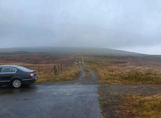
Park at entrance to Iniscarn Forest (C (H833 907)) where there is room for several cars. Follow the forest track for a short distance and then the marked walk (right) through broadleaved trees, mainly beech and holly. This rejoins the forest track where an eye needs to be kept for a crossing point over stream on right. This leads to the forest boundary and a concrete water tank. Cross the fence and the steep NE flank of Slieve Gallion is straight ahead.

A fence heads straight for the top, initially with forest for company. There is a good 600 ft of steep climbing and the views grow with every footstep! This slope has given me great pleasure in kicking steps in deep drifts and in sliding on my bum for 200 feet for a quick descent.

The fence is crossed just before a large cairn on the NE top. Views stretch out over Lough Neagh to the Antrim Hills, Belfast Hills and the Mournes. Make way down past communication masts and along their service road. Most days there is no other soul up here but on some it is full of paragilders or sunday drivers - either day is good.

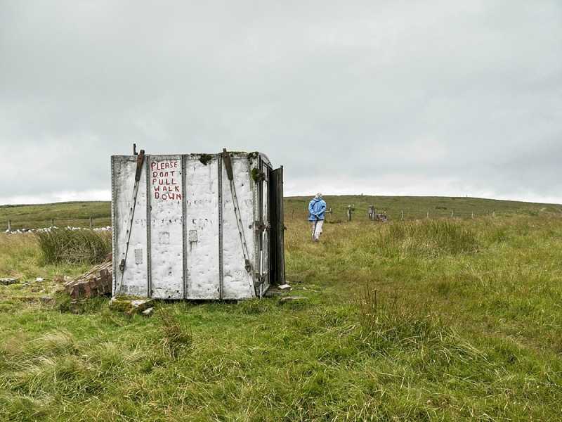
Follow the road for 10 minutes and then take the track off to the R which heads for the main summit. Views are dominated by the higher hills of the Sperrins to the W. Yellow topped marker poles guide the way at even intervals but not too obtrusively. The track is quite wet in places and eventually peters out at an old aluminium shipping container marked with "Belfast Steamship Co Container Service". This is a great place for lunch, especially on days with howling winds, rain or snow.

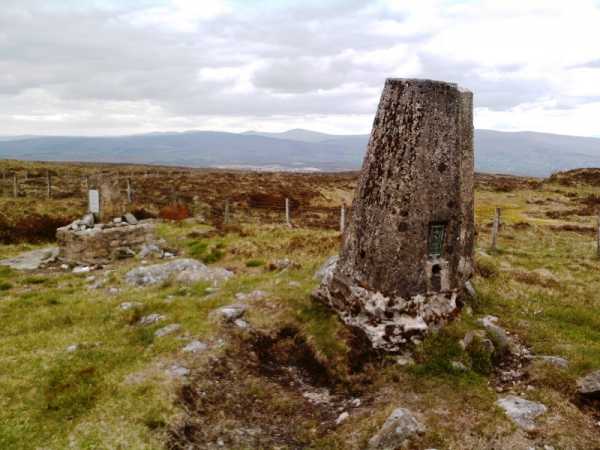
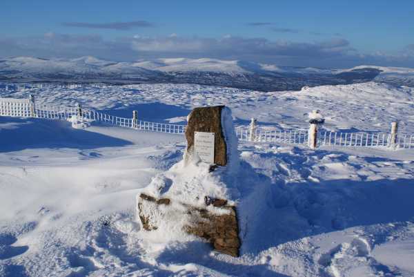
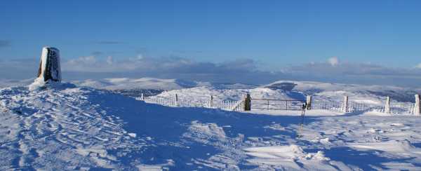
A fence is crossed courtesy of a milk crate either side and a sign welcomes walkers but promotes responsibility. Further makers bring the trig point in short time, 1.75 hours after starting. A memorial is erected here to Ronnie Magwood - I suppose there is no more fitting a place with vast views in all directions, the Bluestacks and Culcaigh being added to those already mentioned - the whole of Ulster basically.

The waymakers continue to Lough Fea, this would be a good traverse of the entire mountain for those with additional transport. There are a number of options for returning to Iniscarn. A straightforward retracing of steps is very satisying, especially if there is snow on the steep slopes. Following the service road further downhill and taking a series of beautiful and peaceful farmtracks. I have also followed the way to Lough Fea for a distance to reach the high and lonely road going through the 'Gap' which i walked back to the forest. Linkback: mountainviews.ie/summit/398/comment/2480/
Read Less
Read More

            MountainViews.ie picture about Slieve Gallion (<em>Sliabh gCallann</em>)
Picture: Trig point looking west to higher tops
gerrym on Slieve Gallion
by gerrym 2 Jan 2010
Climbed 12.3.05 parking on grass verge on a high road opposite Cruckandun Loughs (D (H775 882)). Walk back a short distance and follow a fir lined lane leading to a red barn, climb gate and cross fence for open hill. Head nearly due east for boundary of Mobuy Wood over fairly good but wet ground. A farm track follows the forest boundary uphill and when it ends head NE for the higher ground. The summit area is quite expansive and could be confusing in poor weather, number of fences and wet areas to cross before reaching the trig point at 528 m (one of the few in the Sperrins). Extensive views E as I tracked hail showers making their way over the Lough Neagh basin and W into the rest of the Sperrin range.

Continue NE and drop down to pick up a rough farm track which leads to the tarmac road servicing the communications mast on the northern top. After 2.5 km reach what is not a very asthetically pleasing area of tarmac beside the transmitter, the easy access attracting off roaders to further erode the environment. There is a ruined cairn a little further to the N and the same quality views. Drop down W where rocky bluffs and ravines provided shelter from the howling wind and hail showers for lunch. Continue down towards the road and will pick up an old raised bog road which makes for pleasant walking. This reachs the road proper and a very quiet walk back to the car. It is worth while having a walk around Crockandun Loughs which are the result of sand and gravel extraction, with areas of the workings still being restored. Also worth visiting Lough Fea which is only a few minutes away and has a walk around its shores.
Can also approach from the NE at Iniscarn Forest which has some delightful walking through broadleaf trees and then pines as height is gained. The views open out spectacularily as follow forest tracks steeply uphill onto open hillside. There is a short but pretty steep haul to the top following a fenceline. Reach a large cairn and even larger views covering all of Lough Neagh, the whole range of the Antrim Hills and across to the hills of Newry & Mourne. Pass the communication mast and can use the road for a stretch as outlined above. The return is down the road and back to the forest. Linkback: mountainviews.ie/summit/398/comment/1606/
Read Less
Read More

            MountainViews.ie picture about Slieve Gallion (<em>Sliabh gCallann</em>)
Picture: View across summit
mcna on Slieve Gallion
by mcna 5 Mar 2007
I walked Slieve Gallion yesterday (Saturday) and what a day! The weather was perfect, the views amazing and the mountain, in general, was just beautiful! Coming from Omagh, we drove to Moneymore and about 200m outside the town there is a sign on the right hand side for Slieve Gallion 4 miles. I took this road to a cross roads and the road straight in front is the road up the mountain. There are a few houses on the road but I think the road’s main purpose is to service the telecommunications mast at the top. I had planned to start the walk from a viewpoint up this road so we drove up and parked at the picnic area and the views were spectacular when we emerged from the car! We followed the road to the first summit with the masts, meeting a lovely couple from Magherafelt on the way. We past the masts and over to the cairn and I stood in awe of the amazing views. I have heard that Slieve Gallion is good for views but this was unbelievable! The clouds threw animated shadows over the high and central Sperrins. Lough Neagh in its entirety was in view. The Antrim hills, Blue stacks – all visible! I managed to tear myself away and walked down the road again – point of note. The litter along this top part of the road after the cattle grid is a disgrace. Obviously caused by those who drive to the top and think its fine to eject their litter through the window. I had a plastic bag and collected as much that would fit and stuck it in my rucksack! It really makes me angry at the thoughtlessness of some people! We then left the road at the track Gerrym has mentioned and walked to the main summit. This is an easy enough walk on a dry day and we were very lucky. We kept an eye on the rain storms moving over the high Sperrins but they bypassed us. From the trig point we had spectacular views and since it was a good day we thought we’d take the “scenic” route back to the car. Instead of going back to the road which we should have done, since we only intended to have a short walk - we set off down along the fence - Very steep with some dangerous outcrops. Great care required in places. We walked east, traversing the slope and from the map we had two rivers to cross – unfortunately we met at least 6 fast flowing streams that were set, deeply into gully’s we spent A LOT of time looking for safe crossing points, with the result we had to keep dropping height, which was taking us further away from the car park. Anyway, after endless barbed wire fences and stream crossings we eventually hit the road and then had a 15 minute uphill walk up the car. Great walk, great day but we added an extra 2 hours onto our journey by coming back the way we did. It would have been better to park at Carndaisy forest, walk up the road and just drop down straight off the main summit without the hassle of crossing the deeply gullied streams! We live and learn and we had some laugh trying to get over the barbed wire fences without injury! Linkback: mountainviews.ie/summit/398/comment/2628/
Read Less
Read More

            MountainViews.ie picture about Slieve Gallion (<em>Sliabh gCallann</em>)
Picture: Shipping container as shelter.
Shelter near top.
by simon3 22 Aug 2021
As of August 2021, around 300m east of the top is this small shipping container which appears to be intended for use as a shelter. It has seats in it.

There are signs painted on it requesting the landowner not to prevent access to the mountain.

The very flat summit is to the right of the container in the picture. Linkback: mountainviews.ie/summit/398/comment/23247/
Read Less
Read More
EDIT Point of Interest
text
Videos


Recent Contributions
x
Conditions and Info
Use of MountainViews is governed by conditions and a privacy policy.
Read general information about the site.
Opinions in material here are not necessarily endorsed by MountainViews.
Hillwalking is a risk sport. Information in comments, walks, shared GPS tracks or about starting places may not be accurate for example as regards safety or access permission. You are responsible for your safety and your permission to walk.
See the credits and list definitions.

OSi logo
OSNI/LPS logo
Open Street Map
(Various variations used.)
British summit data courtesy:
Database of British & Irish Hills