This website uses cookies, which are small text files that the website puts on your device to facilitate operation. Cookies help us provide a better service to you. They are used to track general user traffic information and to help the website function properly.
Feature count in area: 115, by county: Wicklow: 108, Kildare: 4, Wexford: 2, Carlow: 3, of which 1 is in both Wexford and Wicklow, of which 1 is in both Carlow and Wicklow,
OSI/LPS Maps: 28B, 55, 56, 61, 62, AWW, EW-DM, EW-LG, EW-WE, EW-WS
Highest Place: Lugnaquilla 924.7m
Starting Places (205) in area Wicklow: 1916 Memorial Car Park, Aghavannagh Ow Bridge, Aghowle Wood, Altidore Wood Entrance, Annacurra National School, Annalecka Bridge, Asbawn Brook L8350, Aughrim National School, Ballard Road, Ballinabarny Gap, Ballinagappoge Bridge Layby, Ballinagappoge Mountain Hairpin, Ballinagore, Ballinahinch Wood, Ballinastoe MBT CP, Ballinastraw South, Ballineddan Upr Fork, Ballinfoyle Upr Cross, Ballycoog, Ballycreen Brook Bridge, Ballycumber, Ballycumber Bridge, Ballycumber Lane, Ballycumber Wicklow Way, Ballylerane, Ballylow Bridge, Ballylusk Quarry, Ballymanus Lane, Ballymoyle Shooting Lodge, Ballynultagh Gap, Ballynultagh Lane, Ballyreagh Wood, Ballyross Forest, Ballysmuttan Long Stone, Baravore, Barnbawn South, Barranisky North, Barranisky West, Bohilla Land Roundabout, Bohilla Lane Mid, Boranaraltry Bridge, Bray Harbour, Brewel West, Brittas Bay North CP, Buckroney Sand Dunes CP, Bus Terminus, Camera Hill Track Cross, Castletimon Wood North, Clara Vale, Clone House Road, Clonegal, Cloon Wood Cp, Coate Bridge, Coolballintaggart Ledge, Coolbawn House Lane, Cransillagh Brook , Crone Wood CP, Crossbridge, Crossoona Rath, Cummer Wood South, Curtlestown Wood CP, Deputy's Pass CP, Derralossary Church, Derry River Bridge, Devil's Glen CP, Devil's Glen Wood, Djouce Wood Calary, Djouce Wood Lake, Djouce Wood Long Hill, Donard, Donnelly's Lane Car Sales, Drumgoff Forest, Dunranhill North, Dunranhill SE, Dunranhill South, Dwyer McAllister Cottage CP, Enniskerry, Fentons Pub, Fitzsimons Park GAA, unuseableFlemings Footbridge Glen Rd, Gap Pub, Gap Road, Glen Beach CP, Glen of the Downs CP, Glenbride Lane, Glenbride Lodge, Glencree Reconciliation, Glendalough, Glenealy GAA, Glenmacnass Tonelagee CP, Glenmalure Hostel, Glenmalure Lodge, Glenmalure Waterfall, Glenview Hotel, Gowle House, Great Sugar Loaf CP, Grove Bar, Heffernans Well Wood, Hill View, Hollywood Glen, JB Malone CP, Johnnie Fox Pub, Keadeen NE trail, Keadeen Trailhead, Kevins Way Footbridge, Kilbride Army Camp Entrance, Kilcandra South, Kilcommon View, Killalongford Wood, Kilmacrea Cross Roads, Kilranelagh House Gate, Kilruddery Car Park, Kilruddery Cottages, Kings River, Kippure Bridge, Kippure Estate, Kippure Transmitter Gate, Knickeen Cross, Knocknaboley Lane Leeraghs Bog, Knocknaboley Lane Stone Cottage, Knockrath Little, Knockree west, Kyle Loop North, Lackan Wood S, Lake Dr Fraughan Brook, Lake Drive, Lake Park Cross, Lake View Pub, Laragh Free Car Park, Laragh NSch, Lead Mines CP, Liffey Bridge, Liffey Head Bridge, Lough Bray Lower, Lough Bray Upper, Lough Tay North Viewing Point, Lough Tay Wicklow Way CP, Luglass Lane L97561, Lugnagun Track, Macreddin Village, Mangans Lane, Military Road Carrigshouk Hill, Military Road Inchavore River Nth, Military Road Inchavore River Sth, Military Road NW Lough Tay, Military Road Ballyboy Bridge, Military Road Cloghoge Brook, Military Road Croaghanmoira, Military Road Fananierin, Military Road LaraghWicklow Way, Military Road Slieve Maan, Monspolien Bridge, Moortown House, Mountain Rescue HQ, Muskeagh Little Wood, Nahanagan Lough NE, Novara Avenue, Bray, Oiltiagh Brook Knickeen, Old Bridge Cross, Old Bridge Scouts , Old Wicklow Way entrance, Paddock Hill SE, Pier Gates CP, Powerscourt Waterfall CP, Putland Road, Quintagh East, Raheen Park CP, Raheenleagh East, Railway Walk CP, Rathdrum Railway Station, Rednagh Wood, Rocky Valley, Roundwood, Sally Gap, Sally Gap N, Seefin Trailhead, Seskin SE, Shankill Tributary Bridge, Shay Elliott, Sheepshanks Bridge, Shillelagh, Slievecorragh Track, Slievefoore South, Sraghoe Brook, St John's Church, St Kevins Chair, St Kevins Church, St Kevins Way R756, Stone Circle Bridge, Stookeen South, Stranahely Wood, Stranakelly Cross Roads, Tallyho, Templeboden, Tithewer, Tomcoyle L, Tomriland Wood, Toor Brook, Trooperstown Hill Access, Turlough Hill CP, Upper Lake CP, Vallymount GAA CP, Vartry Reservoir Upper, Zellers Pub
Summits & other features in area Wicklow: Cen: Glendalough North: Brockagh Mountain 556.9m, Brockagh Mountain NW Top 549.5m, Brockagh Mountain SE Top 471.7m, Camaderry East Top 677.3m, Camaderry Mountain 698.6m, Conavalla 734m, Tomaneena 682.4m Cen: Glendalough South: Carriglineen Mountain 456.6m, Cullentragh Mountain 510m, Derrybawn Mountain 476.1m, Kirikee Mountain 474.5m, Lugduff 653.2m, Lugduff SE Top 638m, Mullacor 660.7m, Trooperstown Hill 430m N Cen: Tonelagee: Carrignagunneen 561m, Fair Mountain 571.2m, Stoney Top 713.7m, Tonelagee 815.8m, Tonelagee E Top 668m, Tonelagee South-East Top 545.8m NE: Bray & Kilmacanogue: Bray Head Hill 238.9m, Carrigoona Commons East 242m, Downs Hill 372.9m, Great Sugar Loaf 501.2m, Little Sugar Loaf 342.4m NE: Djouce: Djouce 725.5m, Knockree 342.1m, Maulin 570m, Tonduff 642m, Tonduff East Top 593m, War Hill 684.8m, White Hill 631.1m NE: Fancy: Ballinafunshoge 480m, Kanturk 527.4m, Knocknacloghoge 532.4m, Luggala 593.3m, Robber's Pass Hill 508.9m, Scarr 640m, Scarr North-West Top 559.8m, Sleamaine 430m NE: Vartry: Ballinacorbeg 336m, Ballycurry 301m, Dunranhill 342m, Mount Kennedy 365.9m NW: Blessington: Carrigleitrim 408m, Lugnagun 446.2m, Slieveroe 332m, Sorrel Hill 599.5m NW: Mullaghcleevaun: Black Hill 602.2m, Carrigshouk 572.5m, Carrigvore 682.4m, Duff Hill 720.8m, Gravale 719m, Moanbane 703m, Mullaghcleevaun 846.7m, Mullaghcleevaun East Top 796m, Silsean 698m S: Aughrim Hills: Cushbawn 400m, Killeagh 249m, Moneyteige North 427m, Preban Hill 389m S: Croaghanmoira: Ballinacor Mountain 529.3m, Ballycurragh Hill 536m, Ballyteige 447m, Carrickashane Mountain 508m, Croaghanmoira 662.3m, Croaghanmoira North Top 579.5m, Fananierin 426m, Slieve Maan 547.8m, Slieve Maan North Top 546.1m S: Croghan Kinsella: Annagh Hill 454m, Croghan Kinsella 606m, Croghan Kinsella East Top 562.1m, Slievefoore 414m S: Shillelagh Hills: Lakeen 357m, Monaughrim 206m, Seskin 344m, Stookeen 420m S: Tinahely Hills: Ballycumber Hill 429.7m, Eagle Hill 296m, Muskeagh Hill 398.2m SE: Wicklow South East: Ballinastraw 284m, Ballyguile Hill 188m, Barranisky 280m, Carrick Mountain 381m, Collon Hill 238m, Kilnamanagh Hill 217m, Westaston Hill 270m W: Baltinglass: Ballyhook Hill 288m, Baltinglass Hill 382m, Carrig Mountain 571m, Carrigeen Hill 298m, Cloghnagaune 385m, Corballis Hill 258m, Keadeen Mountain 653m, Spinans Hill 409m, Spinans Hill SE Top 400m, Tinoran Hill 312m W: Cen Lugnaquilla: Ballineddan Mountain 652.3m, Benleagh 689m, Camenabologue 758m, Camenabologue SE Top 663m, Cloghernagh 800m, Corrigasleggaun 794.6m, Lugnaquilla 924.7m, Slievemaan 759.7m W: Donard: Brewel Hill 222m, Church Mountain 544m, Corriebracks 531m, Lobawn 636m, Slievecorragh 418m, Sugarloaf 552m, Table Mountain 701.7m, Table Mountain West Top 563m
Note: this list of places may include island features such as summits, but not
islands as such.
Corriebracks, 531mMountain Coire Breac A name in Irish,
Place Rating ..
(Ir. Coire Breac [PNCW], 'speckled hollow'), Slieveman, Wicklow County in Leinster province, in Arderin Lists, Corriebracks is the 470th highest place in Ireland.
Grid Reference N96738 00268,
OS 1:50k mapsheet 56 Place visited by: 273members, recently by: Carolyn105, MickM45, abacusms, Kaszmirek78, michaelseaver, NualaB, Alanjm, Timmy.Mullen, thomas_g, Jonesykid, BrianKennan, Ansarlodge, John.geary, derekfanning, 500plusclub
I visited this place: NO (You need to be a logged-in member for this.)
Longitude: -6.558226, Latitude: 53.044452, Easting: 296738, Northing: 200268,
Prominence: 81m, Isolation: 2.1km ITM: 696677 700282 Bedrock type: Granite with microcline phenocrysts, (Type 2p microcline porphyritic) Notes on name: Knocknaboley is the name of a townland, though obviously it originally applied to a hill, and indeed may have referred to the same peak as Corriebracks.
Short or GPS IDs, 6 char: Crbrck, 10 char: Crbrcks Linkback: https://mountainviews.ie/summit/392/
Gallery for Corriebracks (Coire Breac) and surrounds
Summary
for Corriebracks (Coire Breac):
Flat, undistinguished peak, sometimes useful in passing.
Summary created by simon3
2021-10-23 10:55:58
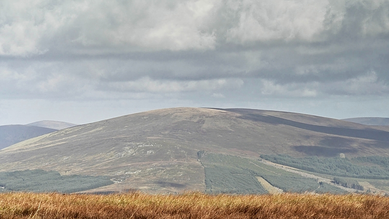
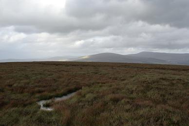
Picture: Corriebracks from the south.
Corriebracks is an extremely flat summit with no particular feature on the top. It has reasonably good long range views from the top, including the Silsean and Moanbane area. It could be considered as a pair with Church Mountain to the NW.
One way of reaching the top is by starting from the forest entrance A (N9744 0174). Follow the track as far as it goes and then beyond in the same SE direction until you reach a boggy ride. Turn right (SW) up this and head for the summit, leaving the forest at around B (N9726 0081). The top is around 730m SW of there over thick heather. (Note, as of 2011, the track is not fully shown on the OS 1:50k).
It's also possible to reach the top from Lobawn, or using a track from Luglass to the north or from Church Mountain. It is possible therefore to use Corriebracks in bigger walks.
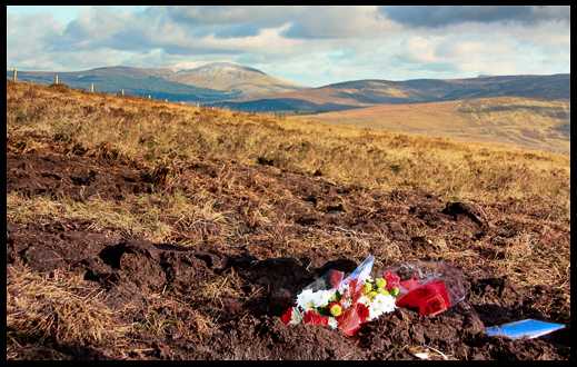
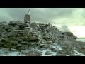
Picture: Crash site. Snow covered Tonlagee in the distance.
simon3 on Corriebracks
by simon3
3 Nov 2008
On Saturday 25th Oct 2008 a Piper PA-28 Cherokee single-engined aircraft crashed here. This point C (N96795 00090) is around 200m from and 20m lower than the very indistinct top of Corriebracks, one of the flattest summits of Wicklow.
As of the following weekend there was no wreckage other than some small scraps of fibreglass. Even the ground has been flattened out.
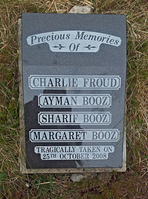
There were four fatally injured victims of the crash, three from one family and a friend, who were all on the way from Gloucestershire Airport to Kilrush Airport in Co Kildare.
I'm sure all the members of and visitors to MountainViews would wish me to express our condolences to the friends and remaining family of the deceased. Linkback: mountainviews.ie/summit/392/comment/3423/
If we were giving out awards for the most nondescript summit in Wicklow, Corriebracks would be right up there with the best of them. It's one of those mountains where you're not quite sure if you've reached the summit or not, so you spend fifteen minutes tramping about looking for the highest point. The photo shows the general area of the summit. It doesn't show the washing machines, plastic bags, and other assorted junk dumped in the col between Corriebracks and Church Mountain. Shameful. Linkback: mountainviews.ie/summit/392/comment/565/
Read Less
Read More
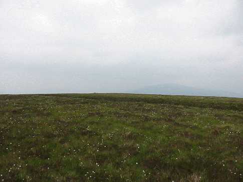
Picture: Looking toward Lobawn from summit.
Hurry-backs-I dont think so!
by Dessie1
7 Jun 2013
Climbed Corriebracks on 12-9-11 in very high winds due to the remnants of hurricane Katia sweeping Ireland.Parked at small clearing (enough for maybe 2 cars) at yellow and black barrier (D (S97817 99895)) at the end of L8349 road.I then followed the road/track for another 150m until I came to a sign warning about Tree felling in the area(E (S97740 00769)).I took a right (East) turn and followed the edge of the forestry which brings you to point F (S97189 99810).From here it is slog through knee deep purple heather and hidden holes filled with water to the summit. Very good views all around-Table mt,Lobawn,Lug etc.I returned via the memorial at the plane crash site and followed previous route back to car.45 mins round trip. Linkback: mountainviews.ie/summit/392/comment/6513/
Read Less
Read More
David McCann on Corriebracks
by David McCann
24 Feb 2005
I walked from Lobawn across by the flanks of Corriebracks to Church Mountain on Sunday 20-Feb-05. The track which flanks the Corriebracks is very bad. We saw quad bikes in the heather up on the Corriebracks as we passed by. As one gets closer to Corriebracks Pass (G. R. G (N957 009)), the track gets better. Linkback: mountainviews.ie/summit/392/comment/1498/
Use of MountainViews is governed by conditions and a privacy policy.
Read general information about the site. Opinions in material here are not necessarily endorsed by MountainViews.
Hillwalking is a risk sport. Information in comments, walks, shared GPS tracks or about starting places may
not be accurate for example as regards safety or access permission. You are responsible for your safety and your permission to walk.
See the credits and list definitions.


 Our Facebook page.