Cookies.
This website uses cookies, which are small text files that the website puts on your device to facilitate operation. Cookies help us provide a better service to you. They are used to track general user traffic information and to help the website function properly.
Features
Nearby features appear when you click the map.
Declutter tracks on map.
Place Search
Video
X
Pub: by
Breifne Area , W: Benbrack Subarea
Feature count in area: 14, by county: Fermanagh: 4, Cavan: 8, Leitrim: 3, of which 1 is in both Cavan and Fermanagh, OSI/LPS Maps: 26, 27, 27A
Highest Place: Cuilcagh 666m

Starting Places (15) in area Breifne:
Aghnacollia Lane, Bellavally Gap, Bencroy, Corneen Wind Farm, Corrawully Lane, Cuilcagh Boardwalk Trail, Dowra, Dowra Sweat House Lane, Glangevlin Cross, Gortalughany Viewpoint, Mullaghgarve Waterfall, Rock Road, Spa Well, Tulliniska Transmitters, Tully Lough

Summits & other features in area Breifne:
N: Cuilcagh Mountains: Benaughlin 370m, Benbeg 539m, Cuilcagh 666m, Mullaleam 424m
NE: Derrylin: Knockninny Hill 191m, Slieve Rushen 404m
SW: Iron Mountains: Bencroy 518m, Knockacullion 562m, Slieve Anierin 585m
W: Benbrack: Bartonny Top 411m, Benbrack 502m, Benbrack NE Top 496m, Benbrack West Top 463m, The Playbank 542m

Note: this list of places may include island features such as summits, but not islands as such.
Rating graphic.
The Playbank, 542m Mountain Sliabh na Cille A name in Irish,
Place Rating ..
Slievenakilla an extra name in English, Cavan County in Ulster province, in Arderin Lists, The Playbank is the 441st highest place in Ireland. The Playbank is the second highest point in county Cavan.
Grid Reference H03328 25835, OS 1:50k mapsheet 26
Place visited by: 74 members, recently by: eimirmaguire, trostanite, abeach, MickM45, Grumbler, Geo, srr45, AlanReid, annem, Loman01, eoghancarton, wicklore, ilenia, IndyMan, Peter Walker
I visited this place: NO (You need to be a logged-in member for this.)
Longitude: -7.949801, Latitude: 54.181507, Easting: 203328, Northing: 325835, Prominence: 187m,  Isolation: 5km, Has trig pillar
ITM: 603276 825840
Bedrock type: Cyclothemic sandstone, siltstone, coal, (Lackagh Sandstone Formation)
Notes on name: Also known as The Playground [OS ½] or Slievenakilla. The name The Playbank relates to the festive assembly held on the mountain on the last Sunday of July, at which sports and dancing took place (Máire MacNeill, 'The Festival of Lughnasa' (pp. 181-82). Also called Carrignahasta.
  Short or GPS IDs, 6 char: ThPlyb, 10 char: ThPlybnk

Linkback: https://mountainviews.ie/summit/370/
Gallery for The Playbank (Sliabh na Cille) and surrounds
Summary for The Playbank (Sliabh na Cille): Isolated Peak of Interest to Rock Climbers
Summary created by Onzy 2014-06-30 14:00:48
            MountainViews.ie picture about The Playbank (<em>Sliabh na Cille</em>)
Picture: pic: Harry Goodman
The curiously named Playbank is an isolated peak not easily combined with other hills. It lies east of Dowra and is most easily reached from along the R200 from there to Glangevlin.

A good starting point is at Corcashel, (A (H008 270)), where there is parking before a green fence enclosing sewage/water works. From here head towards Glangevlin for a few meters before turning right up a lane. Follow the lane for 800m; where the lane forks at an abandoned building. Take the left fork, over the gate and along the edge of a rough field to another gate. From here pick your way uphill, trending right of the true line to avoid the crags. When you reach the very large plain head direct for the summit, a distance of 1k. The ascent should take around 1 to 1 and a half hours and an out-and-back, less than 2 hours 15 minutes.

Further options are available from the tangle of roads to the southwest, parking at an unused gate at around B (H008 232). From here you will need to pick your way around forestry and fencing.

There is both a cairn, and a trig pillar which is located some distance from the true summit.

The crags from the northwest around to the east of the summit are fertile ground for rock climbers and there are many named routes in the area.
Linkback: mountainviews.ie/summit/370/comment/5129/
Member Comments for The Playbank (Sliabh na Cille)
Comment create / edit display placeholder

            MountainViews.ie picture about The Playbank (<em>Sliabh na Cille</em>)
Picture: mass rock on S slopes
gerrym on The Playbank
by gerrym 17 Jun 2006
Climbed from the S, driving along a rough track and parking at an unused gate (B (H008 232)) with good views already down over Lough Allen. Walk uphill alongside a steep river valley, past sheep pens and long abandoned dwellings. The track becomes overgrown and at one of the old houses turn right downhill (C (H028 239)) to reach the mass rock (
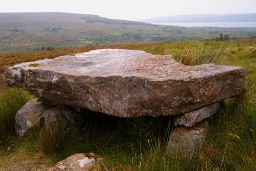
D (H031 237)) - this would be a great spot for an open air service as can see from the picture. Continue SE crossing a stream and numerous stone boundaries, hinting at the extent of farming here in the past. Climb along the edge of the trees to reach a forest track (E (H035 235)), follow uphill past the clearfell with good views across to Bencroy and Slieve Anierin. There is a barely discernable track down to the R through the clearfell which crosses a stream and then rises and heads for the forest boundary again. Cross the double fence and over the open moorland for the fringes of Lough Nambrack which sits in a little bowl, with a glimpse of smaller Knockgorm Lough beyond slightly higher up. I headed N back to the forest edge and rockier ground which brought me to Altshallan Lough (F (H049 243)) - ever widening views here down over L Allen and the loughs just passed. There were a number of dragon flies busily patrolling the pools of water here and i was very much aware that the ground underfoot would normally be a lot wetter. I continued NW,away from the forest top, looking across to the long back of Cuilcaigh and the large cairn to the E. Drop down to cross a stream and then climb to the line of cliffs at Carrigamhasta (
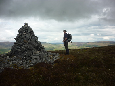
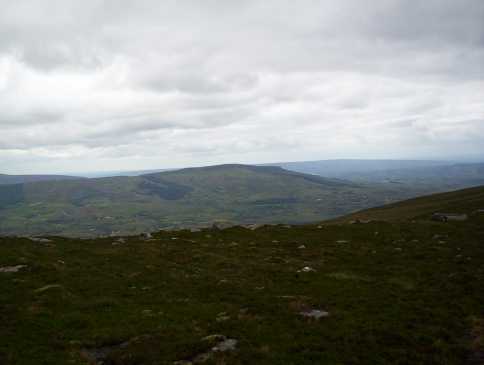
G (H040 247)) where the whole round of the surrounding hills comes into focus. Still NW over peat haga and bare rock to the line of N cliffs, there is now a fairly discernable track skirting above the edge of the hillside which leads to the summit area and trig pillar. Views are far reaching - NW to Sligo hills; N to the Bluestacks; NE to the Sperrins and closer the surounding hills with gentle slopes hiding thier cliff faces. There is a large cairn and a smaller one slightly further on. i dropped down on a bearing of 250" with the best views of L Allen, along the forest edge, past the sheep pens and abck to the car. A walk of 3.5 hours where i met no one else which had fantastic views and variety of ground. Studying the map will give a multitude of options for approaching this hill. Linkback: mountainviews.ie/summit/370/comment/2407/
Read Less
Read More

            MountainViews.ie picture about The Playbank (<em>Sliabh na Cille</em>)
Picture: The Playbank from Cuilcagh
Way up from Corcashel
by eflanaga 9 Apr 2018
(Climbed 15-03-06) I had a half day at my disposal and since I had all the necessary gear in the boot I decided to bag a hill. I plumped for The Playbank (Slievenakilla) given its relative isolation from other 500+ metre mountains so it is one of those you are unlikely to bag along with others as part of a circuit. ITime available dictated a fairly short walk.

After a deal of deliberation I chose to start from Corcashel (A (H008 270)) about 1.8K east of Dowra on the Glangelvin road. The lane is sandwiched between what appears to be a water/sewage works behind green corrugated fencing and an entrance to a forest area. I parked beside the fencing and walked the few metres down to the start of the lane which quickly becomes rough track just after passing the only inhabited dwelling. The lane/track runs for about eight hundred metres until it forks at a derelict building. From here I took a bearing of 126 degrees SE to take me through a breach in the cliffs and directly to the summit. Take the left fork which goes through a metal gate and uphill away from the derelict building. Follow track up to another gate through which there is a sheep trail of sorts through the heavy heather/gorse. However, it might be better to cross the fence & stream to the right where the going is much easier. Maintain bearing as you climb crossing another fence.

After around 1.1K (from the fork in the track below) you near a rocky ‘hillock’ beneath the main cliff face. A rush strewn grass track becomes obvious. This meanders up the hill for a short while before sweeping around to the right, thus avoiding the hillock. You could maintain your bearing around the right side of the hillock and engage in a short but fairly steep scramble up through the breach in the cliff. However, I found that the track only veered of to the right for about 150 metres (H (H023 260)) gently rising before it swept back to the left bringing me up above the breach and back on the original bearing.

The summit is about 1K from here. The terrain is fairly firm ground at first before negotiation of a number of peat hags and marshy ground is necessary. More solid ground is reached as you near the final rise to the summit. Unfortunately, mist persisted reducing visibility to around 15m for the duration of the time I was on the summit, meaning there was little to see. I literally turned and retraced my steps within minutes of reaching the top. As I neared the cliffs on my descent the mist lifted a little allowing me a murky glimpse towards the hills across the valley and of Dowra and the northern tip of Lough Allen to my left, suggesting excellent views on a better day. I reached the car some 2.5 hours after I had left it. I had forgotten my camera so picture is one taken from Cuilcagh last Autumn. Linkback: mountainviews.ie/summit/370/comment/2231/
Read Less
Read More

Tom Caslin on The Playbank
by Tom Caslin 29 Aug 2002
A pleasant ridge walk from the summit of Sliabhna Cille(Slievenakilla) to the three lakes, Altsalan, namBreac & Knockgorm and return by Altnasheen. SliabhnaCille is the correct name for the mountain. The Playbank is the slope over Ballinagleragh. Linkback: mountainviews.ie/summit/370/comment/87/
Read Less
Read More

            MountainViews.ie picture about The Playbank (<em>Sliabh na Cille</em>)
Picture: Large cairn near the summit of The Playbank
A lonely top worthy of attention.
by Harry Goodman 13 Jul 2011
I climbed this mountain on Sat 18 June 2011. We took the R 200 E out of Dowra to Corcashel and parked at I (H00700 26950) on the right where there was room to pull off road in front of a high wire fenced enclosure for a water/sewage installation. Walking NE along the road for about 100 metres we turned up a tarred lane also on the right J (H00800 27000). Although the surface is driveable we found that further up it became quite a rough track which eventually was really only fit for tractors. In addition parking would be a problem. About Ikm into the walk we took a left fork, near some derilict farm buildings, passed through a metal gate and ascend up a winding green lane, with a stream on the right, to another gate. Unfortunately I had left my GPS in the car and was unable to mark any of the points on the route for future reference! Having crossed over the gate we continued up the fence line keeping it to our right. The going was rough through untracked deep heather and tussocky grass. Further up we crossed over to the right side of the stream and found the going easier. Ahead we could see a large rock outcrop, with a finger like detached boulder, sitting out from the main cliff face. As we climbed we started to pick up patches of a path (sheep track) which evenually swung us around to the right avoiding the cliff face and made for a small grassy steep climb up on to the rim of the escarpment at around K (H02500 25900). Initially we walked NNE along the rim but after a short time decided to make directly for the top to the SE across a broad, hummocky, boggy and peat hagged moorland crest for almost 1km to the Trig Pillar at 542m. From the top we had fine views of Slieve Anierin and the Arigna Mountains to the S and SW and across NW to the Sligo Mountains. Due N from the top amout 140 metres away is a large well constructed stone cairn (see photo), which stands on the edge of cliffs, with a fine view down over the valley around Glangevlin and across to the Cuilcagh massif as a backdrop. On our way down we followed the edge along the cliffs for a couple of hundred metres, taking care to stay on the left side of the fence and speculated on the advantage of following it around to the point we joined the rim earlier on, rather than cross the moorland crest. However on the way up we had noted a spur running from SE to NW along the mountain with some interesting large rock formations and thought we would go and have a look at these before descending. We therefore headed up NW and across the broad moorland crest to the rocks in question. As this took us a few hundred metres W of our upward route we headed down a broad grassy spur to pick up the stream we followed on our ascent and then down to the start. A throughly enjoyable walk of some 8km,475m of ascent, in around 3 hours. Linkback: mountainviews.ie/summit/370/comment/6407/
Read Less
Read More

            MountainViews.ie picture about The Playbank (<em>Sliabh na Cille</em>)
Picture: Cows Sighing in The Stillness
Of The Western World
by CaptainVertigo 7 Apr 2015
"I stood a while outside wondering would I have a right to pass on ... and I could hear the cows breathing, and sighing in the stillness of the air, and not a step moving any place from this gate to the bridge."

This little quote from Synge's Playboy captures the atmosphere which prevailed at the base of the Playbank on Easter Monday as I ascended through the white blanket of mist that hung over Lough Allen. Overhead, the piercing light of morning blazed. But there was a moment of transition as I passed from obscurity into clarity, and the cattle presided solemnly over it.
I knew that the day would bring really great walking, and it did. But passing into the light was breathtaking. Linkback: mountainviews.ie/summit/370/comment/17911/
Read Less
Read More
EDIT Point of Interest
text
Videos

Users Online
Hjonna
Guests online: 275
Recent Contributions
x
Conditions and Info
Use of MountainViews is governed by conditions and a privacy policy.
Read general information about the site.
Opinions in material here are not necessarily endorsed by MountainViews.
Hillwalking is a risk sport. Information in comments, walks, shared GPS tracks or about starting places may not be accurate for example as regards safety or access permission. You are responsible for your safety and your permission to walk.
See the credits and list definitions.

OSi logo
OSNI/LPS logo
Open Street Map
(Various variations used.)
British summit data courtesy:
Database of British & Irish Hills