This website uses cookies, which are small text files that the website puts on your device to facilitate operation. Cookies help us provide a better service to you. They are used to track general user traffic information and to help the website function properly.
Feature count in area: 65, all in Kerry,
OSI/LPS Maps: 78, 83, 84, 85, EW-KNP, EW-R
Highest Place: Stumpa Dúloigh 784m
Starting Places (66) in area Dunkerron Mountains: Ballaghasheen Coilte, Ballaghasheen Pass Viewpoint, Ballaghbeama Gap, Bohacullia, Bridia Valley End, Cahersavane Road, Cahersavane Schoolhouse, Cloon Lough NE, Cloon Lough SE, Coad Cemetery, Coad Road End, Com an Chiste, Coomaclarig Bridge, Coomnahorna River, Coomyanna Bridge, Dereenavurrig, Derreendarragh Church, Derrynane Quay, Dunkerron Mid, Eagles Lough Access Trailhead, Esknaloughoge Forest Trailhead, Fermoyle Farm, Foot Stick Ford Road, Gap of Dunloe Head of, Glashaknockbrassel Stream, Glasheenoultagh Stream, Gortaclohane Lane End, Gortaclohane Lane NE Branch, Gortagowan Wood, Gowlane School Ruin, Gowlanes Wood, Graces Landing, Inchimore West, Isknagahinney Lough E, Kenmare Bridge, Knockanamadane, Knockanaskill N, Knocknasullig, Knocknsallagh Bridge, Laghtacallow, Lissatinnig Bridge Boreen, Looscaunagh Lough W, Lough Barfinnihy CP, Lough Brin S, Lough Coomeen SE, Lough Dromtine NE, Lough Dromtine SE, Lough Fada N, Lough Iskanamacteery N, Lough Iskanamacteery NW, Lough Reagh N, Maghanlawaun Bridia Valley, Molls Gap, Ochtiabh Road, Poulacapple, River Owroe Source, River Sneem Fermoyle Loop, Rossacoosane Mid, Sahaleen Bridge, Scarriff Island, Shamrock Farmhouse B&B, Sneem, Tooreenboy Lough, Tooreennafersha Mid, Tooreennafersha South, Waterville Promenade
Summits & other features in area Dunkerron Mountains: Knocknagantee Near West Top 628m Cen: An Bheann Mhór: An Bheann Mhór 674.7m, An Bhinn Láir 514m, Coomcallee 648.9m, Beann na Stiocairí 673.1m, Coomnahorna 590m, Glanbeg 485.8m, Slievenashaska 578m, Slievenashaska South Top 565.4m Cen: Knocknagantee: Knockmoyle 682.1m, Finnararagh 667m, Cnoc Breasail 591m, Knocknagantee 674.3m, Knocknagantee West Top 553m, Coomnacronia 636m, Coomura Mountain 666m Cen: Mullaghanattin: An Cnoc Riabhach 534m, Beann 752m, Beann Far SW Top 636.2m, Beann NE Top 692m, Beann South Top 639m, Beann SW Top 657m, Sallagh 570m, Mullaghanattin 773m, Mullaghanattin East Top 594m, Sallagh South-West Top 543m E: Kenmare: Gortamullin 205m, Knockanaskill 356m, Letter South 362m N: Knocknacusha: Knocknacusha 547m NE: Knocknabreeda Ridge: Crossderry 489m, Knocknabreeda 569m, Mothaillín 506m NE: Knocknagapple: Bascadh 595m, Bascadh West Top 569m, Boughil 631m, Cnoc na gCapall 639m, Knocklomena 641m NE: Stumpa Dúloigh: Broaghnabinnia 745m, Knockaunanattin 569m, Knockaunanattin West Top 466.1m, Stumpa Dúloigh 784m, Stumpa Dúloigh SE Top 780m, Stumpa Dúloigh SW Top 663m SW: Caherdaniel: Farraniaragh Mountain 468m, Eagle Hill 155m, Reenearagh 162m, Beenarourke 304m, Knocknasullig 117m, Cahernageeha Mountain 498.7m SW: Coad ( Castle Cove ): Beenrour 418m, Eagles Hill 549m, Mullaghbeg 509m SW: Coomduff: Coomduff 244m SW: Deenish: Deenish Island (2) 144m SW: Esknaloughoge: Esknaloughoge 416m, Esknaloughoge North Top 420m SW: Scarriff: Scarriff Island 252m SW: Sneem: An Bheann Mhór 309.3m, Dereenavurrig Hill 261m, Knockanamadane 270m, Knocknafreaghane 316.5m, Knocknagullion 413m SW: Staigue: Staigue Top 459m, Staigue NE Top 435m
Note: this list of places may include island features such as summits, but not
islands as such.
Knocknacusha, 547mMountain Cnoc Osaidh A name in Irish,
Place Rating ..
(Ir. Cnoc Osaidh [TH], 'hill of the encampment'), Kerry County in Munster province, in Arderin Lists, Knocknacusha is the 429th highest place in Ireland.
Grid Reference V67543 78222,
OS 1:50k mapsheet 78&83 Place visited by: 57members, recently by: maoris, John.geary, Deise-Man, Taisce, chelman7, Ulsterpooka, abcd, eoghancarton, annem, learykid, daitho9, mountainmike, MichaelE, eamonoc, jimbloomer
I visited this place: NO (You need to be a logged-in member for this.)
Longitude: -9.926831, Latitude: 51.940717, Easting: 67543, Northing: 78222,
Prominence: 252m, Isolation: 1.6km ITM: 467524 578266 Bedrock type: Well-bedded grey sandstone, (Lough Acoose Sandstone Formation) Notes on name: This peak overlooks Ballaghisheen (Ir. Bealach Oisín). The anglicisation Knocknacusha seems unrelated to Cnoc Osaidh and suggests an Irish form Cnoc na Coise.
Short or GPS IDs, 6 char: Kncknc, 10 char: Knckncsh Linkback: https://mountainviews.ie/summit/364/
Gallery for Knocknacusha (Cnoc Osaidh) and surrounds
Summary
for Knocknacusha (Cnoc Osaidh):
There and back again
Summary created by Peter Walker, jackill
2018-11-20 21:47:36
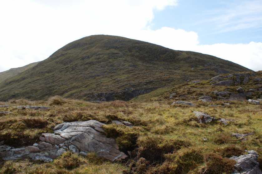
Picture: Knocknacusha on the approach from Ballaghisheen
You can start at Ballaghisheen, a mountain pass BSheen Ps (V671 792). Space here for 3-4 cars. Ballaghisheen is at just over 300m so the climb to the top at around 551m is not a great strain.
There is a sign advising that access is prohibited however the broken fence and tracks uphill indicate access must be frequent.
Head uphill skirting around the mountains east side initially which will being you to the bottom of a deep, wide cleft in the ridge. It is pointless trying to climb up before this as you need to descend into it and climb out of this cleft in any case to access the summit route.
Climb up then skirting the steep edge of a corrie-like cliff (no water though) before heading directly for the flat grassy summit.
A visit to Knocknacusha is probably best seen as a short trip, not as part of a longer route. The sort of place you can try if you want an easy walk, but not without its rewards. You can start at Ballaghisheen, a mountain pass. There's space for just a few cars here, if you are driving. Ballaghisheen is at just over 300m so the climb to the top at around 551m is not a great strain. The summit is unexciting -- there is a small pile of rocks at the top.
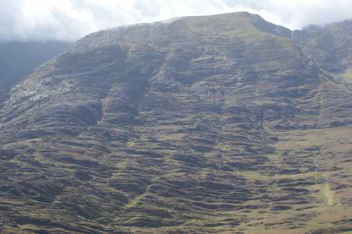
The view south is towards Coomura Mtn (666m) over an area of very broken ground with a lot of bare rock. Just right of centre near the top of the picture is a big glacier flattened slab. On the way up to Knocknacusha there's a couple of similar pieces of glacial handiwork to look at. Linkback: mountainviews.ie/summit/364/comment/1846/
Read Less
Read More
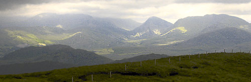
Picture: Reeks and North Iveragh Mtns
simon3 on Knocknacusha
by simon3
2 Aug 2005
While you are on Knocknacusha take a walk along the east ridge. You can go over 600m without dropping much. The view is great for so little work. To your right Cloon Lough will come into view between you and the well known Mullaghannatin area. To your left Colly mountain and the southern arm of the Glenbeigh horseshoe. The picture shows the front view including the south side of the Reeks in the clouds on the left, the sharp peak of Broaghnabinnia just right of centre and the lumpy mass of Stumpa Duloigh (784m) to its right. Linkback: mountainviews.ie/summit/364/comment/1848/
Read Less
Read More
Picture: Coomura Mtn from Knocknacusha. After you...
Peter Walker on Knocknacusha
by Peter Walker
19 May 2009
As Simon has suggested, this works well as a short trip from Ballaghisheen (BSheen Ps (V671 792)), a short boggy and bumpy section giving way to an easy-ish climb. But I think his picture doesn't dissuade any aspirant ascentionists thinking of doing Coomura via this top nearly effectively enough, so that's my excuse for posting a pic looking in much the same direction: it looks VERY impressive from here. Linkback: mountainviews.ie/summit/364/comment/3770/
Read Less
Read More
Picture: The Reeks and Coomloughra Horseshoe from afar.
Nice end to a day out.
by muddyboots
23 Feb 2017
Similar to the other contributors, this is not a single summit day out. I did it after Colly. It's an hour or so with a coffee break. Start at the Ballaghasheen pass (spectacular drive in & out) and head slightly westwards starting at a metal pylon. No broken fences or signs here. Skirt slightly on the west side until the first few rock shelves are climbed. I advise going up on the lefthand side (steep) and down on the left hand side (less steep). The views are superb! Summit is unremarkable. Linkback: mountainviews.ie/summit/364/comment/18849/
Use of MountainViews is governed by conditions and a privacy policy.
Read general information about the site. Opinions in material here are not necessarily endorsed by MountainViews.
Hillwalking is a risk sport. Information in comments, walks, shared GPS tracks or about starting places may
not be accurate for example as regards safety or access permission. You are responsible for your safety and your permission to walk.
See the credits and list definitions.


 Our Facebook page.