Donation Request 2024

DONATE
Members and Supporters, the MountainViews Committee requests your help to meet the costs of the website and of other activities such as insured events or publications.

You do not have to be logged in to donate.

Welcome to MountainViews
If you want to use the website often please enrol (quick and free) at top right.
Overview
Detail
Zoom: ??
For more map options click on any overview map area or any detail map feature.
Detail Map Features
Find Suggested Walks
Find hill, mountain, island, coastal feature.
Videos


Recent Contributions
Get Notifications

Lake District: Dale Head Horseshoe

Crocknasharragh: Impressive views on nitial ascent.

Crocknasharragh: Fine views on ascent

Lake District: Coledale Horseshoe

Cunnigar: Short trek to summit

Longish walk to isolated top

Westtown Hill: Tramore's Highest Point

Knockbrinnea West Top: Eflanagan on the Knockbrinneas

Ascending the Knockbrinneas from the north.

Knockbrinnea West Top: Larger Twin

Lobawn Loop - Clockwise avoids any steep ascent! Easy stream crossing.

Knockaunanattin West Top: Views, loughs and a navigational aid.

Conditions and Info
Use of MountainViews is governed by conditions and a privacy policy.
Read general information about the site.
Opinions in material here are not necessarily endorsed by MountainViews.
Hillwalking is a risk sport. Information in comments, walks, shared GPS tracks or about starting places may not be accurate for example as regards safety or access permission. You are responsible for your safety and your permission to walk.
See the credits and list definitions.
Video display
East Mayo Area   NW: Nephin Subarea
Place count in area: 15, OSI/LPS Maps: 23, 24, 31, 32 
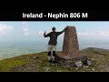
Highest place:
Nephin, 806m
Maximum height for area: 806 metres,     Maximum prominence for area: 778 metres,

Places in area East Mayo:
E: Charlestown Hills:   Knock Hill 213mMullaghanoe 234m
N: Foxford Hills:   Carranarah 197mGortnadrehy 143m
NW: Nephin:   Cuilkillew 130mNephin 806mTristia 322m
NW: Pontoon Hills:   Crucknaree 297mFarbreiga 395mKnockaglana 154m
S: Kiltimagh Hills:   Rush Hill 197mSlieve Carn 262m
W: Croaghmoyle:   Burren 396mCroaghmoyle 430mMuckanagh Hill 220m

Note: this list of places includes island features such as summits, but not islands as such.
Rating graphic.
Nephin Mountain Néifinn A name in Irish (Ir. Néifinn [OSI], poss. 'sanctuary' [PDT]) Mayo County in Connacht Province, in Arderin, Vandeleur-Lynam, Irish Highest Hundred Lists, Quartzites and psammitic schists. Bedrock

Height: 806m OS 1:50k Mapsheet: 23/31 Grid Reference: G10347 07975
Place visited by 414 members. Recently by: abeach, Hjonna, Tuigamala, rhw, PiotrR, Magic, Carolineswalsh, matthewh, ToughSoles, muddypaws, srr45, Sonyalaw, notjulians, Leona-S, kitchen
I have visited this place: NO (You need to be a logged-in member to change this.)

Longitude: -9.368335, Latitude: 54.013253 , Easting: 110347, Northing: 307975 Prominence: 778m,  Isolation: 3.5km,   Has trig pillar
ITM: 510317 807981,   GPS IDs, 6 char: Nephin, 10 char: Nephin
Bedrock type: Quartzites and psammitic schists., (Nephin Formation)

Nephin is a problematic name and few sources venture an interpretation. It is mentioned as one of the twelve great mountains of Ireland in Cath Maige Tuired (The Second Battle of Moyturra), where it is called Nemthenn. This is suggestive of nemeton, a Gaulish term for a sacred clearing in a wood or sacred grove. The word recurs throughout the Celtic world, from the Galatian Drunemeton ('sacred oak-grove' in modern Turkey) to Nemetobriga in Spain and Aquae Arnemetiae, the sacred spring at Buxton in Derbyshire. The Old Irish fidnemed refers to a shrine in a forest. [Barry Cunliffe, The Ancient Celts]. There seem to be no survivals of traditions connected directly with Nephin to confirm this. However, Nephin's much lower neighbour Tristia (322m, 4km to the NW) was the site of Lughnasa celebrations until recent times [Máire MacNeill]. Glen Nephin is the only example of an Irish glen (apparently) named after the mountain overlooking it. Walks: for a route to the summit from the E, see Whilde & Simms, New Irish Walk Guide - West and North, 69.   Nephin is the highest mountain in the East Mayo area and the 37th highest in Ireland. Nephin is the second highest point in county Mayo.

Linkback: https://mountainviews.ie/summit/36/
COMMENTS for Nephin (Néifinn) 1 2 3 4 5 6 Next page >>  
Follow this place's comments
MountainViews.ie Picture about mountain Nephin (<i>Néifinn</i>) in area East Mayo, Ireland
Picture: Nephin from the Nephin Begs.
 
Great views - steady, long climb on isolated, landmark mountain in NW Mayo
Short Summary created by markmjcampion, simon3, paddyhillsbagger  18 Aug 2023
Nephin is a conical, stand-alone mountain in the E Nephins with a steady, steep and long climb. In cloud watch out for steep ground on all approaches. Great views over L. Conn, Nephins, Clew Bay and C. Patrick. There are access issues on the E side so best avoid this until rectified.

SW. Start at G08273 05257 starA[parking and easy access to the hillside after forest ends]. Cross 2 fences and head just N of E, hitting the ridge at G08990 05560 starB - then follow a sporadic path most of the way up. The short heather and grass eventually cedes to a stony slope, cairned to the top. There is steep ground around the summit so be wary in fog. Alternatively start at G08714 04373 starC, going through a gate to a farm. Ask permission to proceed and if granted (no dogs) use the thoughtfully provided stiles to start climbing. Aim for the ridge again at G08990 05560 starB [2 hrs]

N. Park in layby G10899 10381 starD. Cross the fence here and follow the stream (not marked on MV map) uphill with the slope increasing as you ascend. Alternatively, take forest tracks up to G10604 09991 starE and follow directions given in track/3768. [1.5 to 2 hrs]

SE. There is a potential route from G11912 05803 starF but there are access issues as of Dec 22 so best avoided for now.
With a prominence of 778m Nephin is 7th most prominent in Ireland. Uniquely for a high prominence summit, N's isolation (the distance to another MV summit) is 3.4km compared to .4 to 2 for others.

Natable tracks incl track/3768, track/1544 and track/2755. Linkback: https://mountainviews.ie/summit/36/comment/4796/
 
Update on Harry Goodman
by mcrtchly  7 Jul 2014
We climbed Nephin in July 2014 and met with the helpful farmer mention by a number of MV members. He told us it is better not to follow the track through his farm yard, so as to avoid the dogs, but to take the forest track on the left of the parking spot. After about 500m (at G08816 04915 starG) take a new forest road on the right and follow this to the edge of the forest. Cross a stile and turn left to follow the forest boundary and then proceed as described in Harry's comment. Linkback: https://mountainviews.ie/summit/36/comment/17534/
Your Score: Very useful <<  >>Average
 
MountainViews.ie Picture about mountain Nephin (<i>Néifinn</i>) in area East Mayo, Ireland
Picture: View down the NE spur of Nephin
A very pleasant surprise
by Harry Goodman  31 Dec 2015
Many of the comments I had read about Nephin were to the effect that it was a boring mountain both to look at and to climb. This said it has been on my hit list for a very long time and as I had an opportunity to go and see for myself on Mon 24 May 2010 I decided that now was the time to do so. We parked carefully off road at Prughlish Forest G0871104389 starH between two gates, one wooden and locked and a second metal farm gate that was not locked. We went through the metal gate and followed a stoney track NW along the side of the forest up to a farm house where we were met by a howling pack of eight dogs running at us across the field. Fortunately both the sheep farmer and his wife were also in the field and soon had the dogs under control. On asking if we could gain access to the mountain we were told that we were most welcome to do so and the farmer even directed us to a stile he had erected for use by walkers. He also indicated that he had built a number of stiles for this purpose and had even tied plastic sacks around the strand of barred wire to safeguard anyone crossing over. Happy in the knowledge that we were welcome to cross his land we set off in pursuit of Nephin. From the farm house we went to G0915804874 starI and our first stile. Once over we headed across the large field to another fence and stile at G0908905643 starJ. We then followed the line of the fence left to gain the high point and the start of the long ridge up Nephin G0894305418 starK. Once there it is more or less a straight climb NE up the ridge to the top. Indeed the steepest and most troublesome part of the climb is in the first few hundred metres along the ridge where the heather is thickest but soon gives way to much shorter undergrowth. For navigation purposes in poor visability I would suggest two intermediate points at G0970906733 starL and G0990407210 starM before the final walk up to the summit. The climb is steady, long, but not on a difficult gradient. The short heather and grass evenually gives way to a stoney slope which is cairned all the way to the top. Once we had taken in the views from the summit E over Lough Cong, down the impressive NE and SE stoney spurs and then W to the Nephin Beg Range we had our lunch within a stone shelter about 100 metres down the slope. Our descent was by way of ascent. The total distance walked was approx 9.5k, and we were up and down very comfortably in four hours. In my view this is a mountain well worth climbing. By the way, the farmer does not live at the farm and I suspect the dogs would not be left there unattended lest anyone is put off by the possibility of encountering them. Linkback: https://mountainviews.ie/summit/36/comment/5849/
Your Score: Very useful <<  >>Average
 
MountainViews.ie Picture about mountain Nephin (<i>Néifinn</i>) in area East Mayo, Ireland
Picture: Nephin Ice
 
Four Sides
by Gazelle  4 Jan 2016
I've summited Nephin many times and from all directions.
The East route is closest to my house and is therefore my most well trodden although this was before the building of the new water treatment station and I am now considering and advising other routes as there are 2 locked gates at the water station that have to be climbed over and there are plenty of No Unauthorised Entry signs displayed. I did prefer to ascend the most direct route following a straight line as is posible from the stream to the summit.
The North route is now my preferred route and is quite steep but short and sharp and the quickest for me, I usually follow the east ridge of the 'holla', its a great route in bad weather if you're worried about losing your bearings.
The South route from Pruglish forest is probably the most popular particularly with groups as there is a resemblance of a path to the summit, it is long and drawn out and the route through the forestry at the bottom can be tricky to navigate before making it out onto open ground and starting the mountain proper. The West route is my least ascended mainly because it is furthest away from home, it has a wet boggy section to cross at the start before making it onto firmer ground and up the west ridge of the 'holla' .
An excellent challenge is to ascend from the North route and circle the 'halla' ascending one side and descending the other. Linkback: https://mountainviews.ie/summit/36/comment/18415/
Your Score: Very useful <<  >>Average
 
MountainViews.ie Picture about mountain Nephin (<i>Néifinn</i>) in area East Mayo, Ireland
Picture: Nephin from Knockffertagh in Nephin Begs
gerrym on Nephin, 2006
by gerrym  1 Jan 2006
Climbed 26.3.05. Was going to follow route described in "Walk Guide west of Ireland" but this was shrouded in mist with wind coming from E. The sun was breaking through on the W side so I tried my luck and parked at a layby at 109104 starN and approached from the N. There is a gate and bog track leading onto the hill but also a No Trespassing sign so I crossed the fence at the layby and followed the stream uphill. This is through high gorse bushes with thier bright yellow flowers. As the banks of the stream steepen cross to the L and make for a fence climbing the rise. Continue on when the fence ends and eventually the steep bowl of the N corrie comes into view. there is now a steep pull up the W side of the corrie, initially on heather but rockier when gain ridge proper. This is a nice walk with steep slopes either side and the steep walls of the corrie for company. Fantastic views as climb with the waters of Lough Conn dominating the view E as clouds floating over below. To the N and W were the vast flat areas of brown bog , broken only by the contrast of forestry plantations. In the distance the cooling tower of Bellacorick power station (disused ?) rose like an ancient castle. To the W the summit of Glencar just peaked out from a mass of cloud. As reach the top of the ridge there are a couple of small cairns and then a broad stoney area, with further small cairns at intervals guiding the way to the summit trig point. There are substancial remains of a stone structure just to the E of the trig point which I assume are related to sheep farming ? the views from the top were breath taking as all cloud had melted away to blue skies. There was still some cloud in the valleys around but glimpes of Clew Bay and Croagh Patrick to the S came and went and the Nephin Beg mountains and the distinct dome of Slievemore on Achill. Met a fellow walker at the trig point basking in the sun and trying to take in the massive views. Had the pleasure of his company as came down the W side of the corrie - some areas of scree and then slippery heather. Meet up with stream that followed up and back down to where car was parked. Took 3 hours in all at leisurely pace and hit a perfect weather window as the mountain was covered in heavy cloud by the time had come down. I really enjoyed this walk and the great views that came with it. Not much scope for continuing a longer walk but with mountain areas within easy drive would be part of a good weekend - I continued on to the Nephin Begs. Linkback: https://mountainviews.ie/summit/36/comment/1632/
Your Score: Very useful <<  >>Average
 
bryanmccabe on Nephin, 2009
by bryanmccabe  1 Feb 2009
Climbed Nephin on 31/1/09. Parked at the entrance to Pruglish forest, to the SW of the mountain, walked up past the farmhouse and along the edge of the forest, under the pylons. At the end of the forest, we crossed a stile and veered slightly left to pick up the mountain shoulder at a low level. It is quite a distance from the forest to the summit (about 3km). The cloud level was about 400m, so it was very difficult to know how far we had left to go, with all the false tops along the way. Once we reached about 650m, the gradient became very mild and there were plenty of snow patches at that level. We stayed no more than 1 minute at the trig station as we were exposed to a bitter east wind. On the way down, we retraced our steps to about 650m and then took a southerly route off the mountain to meet up with a minor road leading to the road running NE/SW on the south of the mountain. This involved a steep descent over slippy peat. Once below cloud level, the views over Lough Beltra and Clew Bay were spectacular.
In terms of physical effort, Nephin is relatively straight forward for an 800m+ mountain. Linkback: https://mountainviews.ie/summit/36/comment/3553/
Your Score: Very useful <<  >>Average
 
COMMENTS for Nephin (Néifinn) 1 2 3 4 5 6 Next page >>
(End of comment section for Nephin (Néifinn).)

OSi logo OSNI/LPS logo
Some mapping:
Open Street Map
(Various variations used.)
British summit data courtesy:
Database of British & Irish Hills
(Creative Commons Licence)
MountainViews.ie, a Hill-walking Website for the island of Ireland. 2400 Summiteers, 1480 Contributors, maintainer of lists: Arderins, Vandeleur-Lynams, Highest Hundred, County Highpoints etc