Members and Supporters, the MountainViews Committee requests your help to meet the costs of the website and of other activities such as insured events or publications.
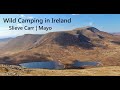
Feature count in area: 15, all in Mayo,
OSI/LPS Maps: 23, 24, 31, 32
Highest Place: Nephin 806m
Starting Places (13) in area East Mayo: Bellanaderg Bridge, Cloondaff Church, Cuilkillew S, Glasheens River, Gortnadrehy South, Gortnadrehy West, L5709 Lugnamannaun River, Lough Ben, Loughanaveeny, Nephin CP Fiddaunduff, Nephin CP Forest Road, R312 Boghadoon, R312 Prughlish
Summits & other features in area East Mayo: E: Charlestown Hills: Knock Hill 213m, Mullaghanoe 234m N: Foxford Hills: Carranarah 197m, Gortnadrehy 143m NW: Nephin: Cuilkillew 130m, Nephin 806m, Tristia 322m NW: Pontoon Hills: Crucknaree 297m, Farbreiga 395m, Knockaglana 154m S: Kiltimagh Hills: Rush Hill 197m, Slieve Carn 262m W: Croaghmoyle: Burren 396m, Croaghmoyle 430m, Muckanagh Hill 220m
Note: this list of places may include island features such as summits, but not
islands as such.
Tristia, 322mHill Troiste A name in Irish,
Place Rating ..
(Ir. Troiste [logainm.ie], 'tripod'), Mayo County in Connacht province, in Binnion Lists, Tristia is the 1109th highest place in Ireland. Tristia is the most northerly summit and also the second most westerly in the East Mayo area.
Grid Reference G07258 09509,
OS 1:50k mapsheet 23,31 Place visited by: 9members, recently by: markmjcampion, eamonoc, Garmin, chalky, Fergalh, sandman, maxim, shaunkelly, Kev Mac
I visited this place: NO (You need to be a logged-in member for this.)
Longitude: -9.415924, Latitude: 54.026511, Easting: 107258, Northing: 309509,
Prominence: 207m, Isolation: 3.5km ITM: 507228 809518 Bedrock type: Mixed schists, minor basic metavolcanics, (Bunaveela Lough Formation) Notes on name: There are several hills of this name, one further west in Mayo, one in Fermanagh (anglicised Trustia) and one near Mullaghmast in Co. Kildare (Trustiu in the Metrical Dindshenchas). Why these hills have a name meaning 'tripod' is unclear, but some at least appear to have had a ritual significance. There are traditions connected with Tristia in Mayo which preserve elements of the pagan festival of Lughnasa. As well as climbing the hill, it was tradition to visit St. Patrick's Well and the Blessed Virgin's Well at its foot. These wells were reputed to offer cures for eye ailments and for jealousy [MacNeill, 106-07].
Short or GPS IDs, 6 char: Trst, 10 char: Tristia Linkback: https://mountainviews.ie/summit/929/
Decided to do this smaller one to rest the legs after being blown over a couple of times on neighbouring Nephin. I parked at the junction of the forest road and the R316 at A (G078 088). I had intended to turn right at the T -junction of the forest track at B (G078 091) and then follow the edge of the forest up to the summit. Unfortunately this T junction had a fence across the right turn with silage bales behind it. Even though it does still appear as Coillte property I wasn't sure and decided to head for St Patricks Holy Well at C (G073 087) to approach from there. It turns out you could easily turn and park 4 cars at the well.
I then went over a stile at the end of the forest trail and crossed a ditch and turned uphill after about 30m. After that I walked up steeply through the larger trees. No "fir-bashing" required though! Not an easy walk because of the steepness, but not unlike the other mountains in this area. Plenty of fraughaun bushes on this hill but didn't see any on Nephin. Linkback: mountainviews.ie/summit/929/comment/6768/
Read Less
Read More
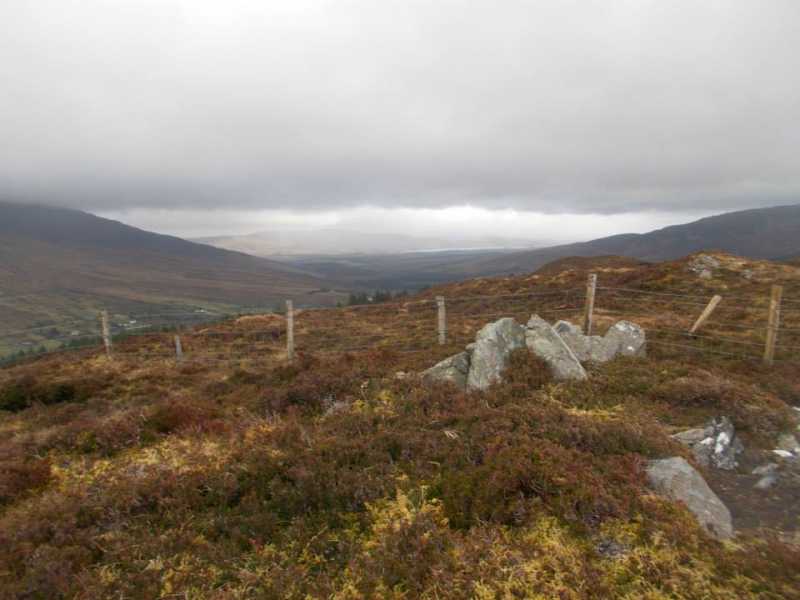
Picture: Stones at summit
Steep climb up forest
by Fergalh
9 Jan 2023
Back in 2014 I followed Shaun Kelly's excellent route description. A steep climb following a rough deteriorating fence line followed until the summit was achieved. This is marked by a pile of rocks great views in all directions, especially towards Nephin. Linkback: mountainviews.ie/summit/929/comment/23792/
Read Less
Read More
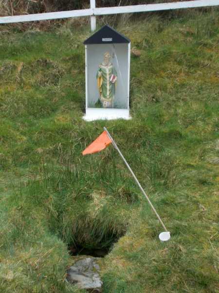
Picture: St Patrick's Well
Golfers make their mark on Tristia
by Fergalh
9 Jan 2023
St. Patricks Well is worth a visit on the ascent even if just to see the Golf flag. Was someone there to pray for a better shots or sprinkle holy water on the clubs..? The mysterious flag was there in 2014 has it survived the years since I wonder Linkback: mountainviews.ie/summit/929/comment/23793/
Use of MountainViews is governed by conditions and a privacy policy.
Read general information about the site. Opinions in material here are not necessarily endorsed by MountainViews.
Hillwalking is a risk sport. Information in comments, walks, shared GPS tracks or about starting places may
not be accurate for example as regards safety or access permission. You are responsible for your safety and your permission to walk.
See the credits and list definitions.


 Our Facebook page.