Donation Request 2024

DONATE
Members and Supporters, the MountainViews Committee requests your help to meet the costs of the website and of other activities such as insured events or publications.
You do not have to be logged in to donate.
Features
Nearby features appear when you click the map.
Declutter tracks on map.
Place Search
Video
X
Pub: by
East Mayo Area , S: Kiltimagh Hills Subarea
Feature count in area: 15, all in Mayo, OSI/LPS Maps: 23, 24, 31, 32
Highest Place: Nephin 806m

Starting Places (13) in area East Mayo:
Bellanaderg Bridge, Cloondaff Church, Cuilkillew S, Glasheens River, Gortnadrehy South, Gortnadrehy West, L5709 Lugnamannaun River, Lough Ben, Loughanaveeny, Nephin CP Fiddaunduff, Nephin CP Forest Road, R312 Boghadoon, R312 Prughlish

Summits & other features in area East Mayo:
E: Charlestown Hills: Knock Hill 213m, Mullaghanoe 234m
N: Foxford Hills: Carranarah 197m, Gortnadrehy 143m
NW: Nephin: Cuilkillew 130m, Nephin 806m, Tristia 322m
NW: Pontoon Hills: Crucknaree 297m, Farbreiga 395m, Knockaglana 154m
S: Kiltimagh Hills: Rush Hill 197m, Slieve Carn 262m
W: Croaghmoyle: Burren 396m, Croaghmoyle 430m, Muckanagh Hill 220m

Note: this list of places may include island features such as summits, but not islands as such.
Rating graphic.
Slieve Carn, 262m Hill Sliabh Chairn A name in Irish,
Place Rating ..
(Ir. Sliabh Chairn [NÓM], 'mountain of the cairn') Slieve Horn an extra name in English, Mayo County in Connacht province, in Binnion Lists, Slieve Carn is the 1256th highest place in Ireland. Slieve Carn is the most southerly summit in the East Mayo area.
Grid Reference M29700 88100, OS 1:50k mapsheet 31
Place visited by: 23 members, recently by: JohnRea, TommyV, FilHil, eamonoc, Richtea, conormcbandon, Garmin, chalky, la1ena, wicklore, bria5n1, Fergalh, juliewoods, Jamessheerin, moggy40t
I visited this place: NO (You need to be a logged-in member for this.)
Longitude: -9.068632, Latitude: 53.837751, Easting: 129700, Northing: 288100, Prominence: 238m,  Isolation: 5.4km, Has trig pillar
ITM: 529665 788114
Bedrock type: Black shale, (Craggagh Shale Formation)
Notes on name: Not named on the OS Discovery Series. Known locally as Slieve Carn or sometimes Slieve Horn. The Metrical Dindsenchas (11th century) refers to Sliabh Cairthinn i nGaileangaibh (barony of Gallen). If this is the same hill, as seems likely, Sliabh Cairthinn (perhaps connected with Ir. cairthe, 'standing stone') would be an early alternative name to Sliabh Chairn, 'mountain of the cairn'. Has been called Cuillalea.
  Short or GPS IDs, 6 char: Slv262, 10 char: SlvCarn

Linkback: https://mountainviews.ie/summit/990/
Gallery for Slieve Carn (Sliabh Chairn) and surrounds
No summary yet for this place .
Member Comments for Slieve Carn (Sliabh Chairn)
Comment create / edit display placeholder

PuterMan on Slieve Carn
by PuterMan 24 May 2009
Slieve Carn on paper may not seem anything to shout about, but it is its isolation from other hills that is it's strong point. The hill stands proudly above the plains of Mayo and from the summit you can see in a sweeping arc from the Pins past The Reek, taking in Clare Island and then on to Nephin, the Ox Mountains, and even on a clear day the top of Errigal, and thence to Ben Bulbin.

It is a pleasant easy walk for the most part if you approach from the West, but in wet weather the last part of the route to the summit across the bog can be treacherous. If you are wanting more strenuous exercise approach from the East [Kiltimagh](1 in 4). The blanket bog is 'farmed' in most places on the hill, and a recent addition has been 4 wind turbines.

Slieve Carn is mentioned in the Statistical Survey Of Mayo (1802) as having coal, and there is also evidence in places of iron deposits. Kestrels, even a buzzard and various other birds have been seen and if you are lucky in summer you may see a flock of Golden Plover.

It is also reported that back in the 70s a UFO was seen hovering over Slieve Carn. Linkback: mountainviews.ie/summit/990/comment/3778/
Read Less
Read More

Tractor Territory!
by three5four0 14 Jul 2010
After reading paddyhillsbaggers comments about the access roads condition, we opted to try the minor road crossing Treannagleragh, and then approach via the summit tracks. We took the minor road at A (M339 890) in Kiltamagh, which brought us to an off set junction at B (M313 898), turn left and then right onto the road that climbs to the masts on Treannagleragh. All I can say is don't approach the hill this way, unless you are driving a 4 wheel drive vehicle, with a good clearance below!

For those who do, continue on up hill past the masts and turn left at C (M296 902), onto a badly rutted — and flooded when we were there — track. Follow this to a track junction at D (M294 890), turn left and after a very short distance right at E (M295 890) onto a slightly better track. There is room to park at 
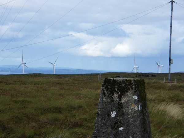
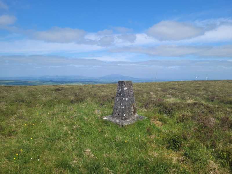
F (M293 879), by the track junction. From here you can make a direct ascent, across bog, to the summit and its Trig Point, returning by the track that runs along the edge of the forest and then along the road back to your 4x4. Despite the rain, there was good views to be had, before the mist rolled in again.

Its best to approach this hill from the West side, given the steepness of the approach roads and tracks, from the Kiltamagh side. The only thing rescuing your stuck car here is a tractor! On the tracks mentioned above, I did spot what looked like walking trail markers, so there may be an attractive alternative approach to be had, from a village below. Linkback: mountainviews.ie/summit/990/comment/5945/
Read Less
Read More

            MountainViews.ie picture about Slieve Carn (<em>Sliabh Chairn</em>)
paddyhillsbagger on Slieve Carn
by paddyhillsbagger 4 Oct 2009
PuterMan is correct in describing the fabulous views to be had from the top of Slieve Carn. Unlike PuterMan I drove up the very rough and steep (1 in 4) access road from the Kiltimagh side ending up only 5 minutes walk from the cairn. I would not advise driving up this route, I bottomed out a couple of times (my car is a large MPV high off the ground) and opted to drive down the West side which is far more gentle. The access road is no doubt both for the turf as well as the wind farm on the summit plateau. Linkback: mountainviews.ie/summit/990/comment/4180/
Read Less
Read More

Sliev Carn
by Fergalh 15 Sep 2013
I climbed this today approached from Kiltimagh take 5th left (L57704) when you are on the balla road from kiltimagh....on the L57704 turn right at first crossroads (after about 3 km) than proceed up mountain till you reach turbines than walk towards TV aeriel that is on its own about one km south..trig pillar is there Linkback: mountainviews.ie/summit/990/comment/15180/
Read Less
Read More

            MountainViews.ie picture about Slieve Carn (<em>Sliabh Chairn</em>)
Picture: Summit Trig
Working Bog and Wind Farm
by TommyV 30 May 2023
Having read the comments about the approach from the East side, I followed a warren of roads on the West side of the hill and ended up parking at G (M29230 89101). From here I followed the approach mentioned by three5four0, mostly on a bog road and then across the bog following some recently cut hoppers to the trig at the summit. Nice views of Nephin and Croagh Patrick in the distance. Linkback: mountainviews.ie/summit/990/comment/23968/
Read Less
Read More
EDIT Point of Interest
text
Videos
Recent Contributions
x
Conditions and Info
Use of MountainViews is governed by conditions and a privacy policy.
Read general information about the site.
Opinions in material here are not necessarily endorsed by MountainViews.
Hillwalking is a risk sport. Information in comments, walks, shared GPS tracks or about starting places may not be accurate for example as regards safety or access permission. You are responsible for your safety and your permission to walk.
See the credits and list definitions.

OSi logo
OSNI/LPS logo
Open Street Map
(Various variations used.)
British summit data courtesy:
Database of British & Irish Hills