This website uses cookies, which are small text files that the website puts on your device to facilitate operation. Cookies help us provide a better service to you. They are used to track general user traffic information and to help the website function properly.
Feature count in area: 62, by county: Cork: 45, Kerry: 24, of which 7 are in both Cork and Kerry,
OSI/LPS Maps: 78, 79, 85, 86, 88, 89
Highest Place: Knockboy 704.8m
Starting Places (47) in area West Cork Mountains: Barley Lake North, Barrboy, Caha Pass, Carranmore, Carrigacappeen, Carriganass Castle, Castle Donovan Car Park, Clearagh House, Coolkellure House, Coomhola Bridge, Corrigatirra, Cousane Gap, Cummer Lough East Road, Derreencollig Wood, Esk Boreen, Fuhiry Wood, Garinish Island Pier, Glasagarav River Bridge, Glasnacummeen Stream, Glengarriff, Glengarriff Nature Reserve CP, Gorteeniher Drimoleague Heritage Walk CP, Gortloughra River Road, Gougane Barra Oratory, Gougane Barra Park CP, Grousemount Wind Farm, Kealkill Village, Knockanuha, Knockbrack South, Lough Atooreen N, Lough Nambrackderg North, Lough Nambrackderg Wood, Lough Nambreacdearg, Mealagh Bridge, Molly Gallivan's Visitor Centre, Nowen Hill West Road, Owvane River Bridge, Pookeen North Top Road, Pooleen Wood Car Park, Priests Leap, Reenroe Bridge, River Roughty, Shandrum Concrete Silo, Sillahertane Stream, Slaheny River Horseshoe, Top of Coom, Turner's Rock Tunnel
Summits & other features in area West Cork Mountains: Cen: Maughanaclea: Maughanaclea Hills East Top 470m, Maughanaclea Hills West Top 452m Cen: Shehy More: Shehy More 545.6m, Shehy More SW Top 446m E: Clearagh: Clearagh Hill 287m E: Currane: Currane Hill 228m N Cen: Douce: Douce Mountain 476m, Doughill Mountain 471m N: Carran: Barnastooka 497m, Bealick 537m, Carran 604m, Carran Far NE Top 561m, Carran Far North Top 506m, Carran NE Top 555m, Carran South Top 567m, Knockantooreen 450m N: Conigar: Conigar 566m, Conigar SW Top 566m, Foilastookeen 540m N: Coomataggart: Carrigalougha 423m, Coomataggart 530m, Coomataggart SW Top 509m, Derrineanig 304m, Lackabaun 472m, Mweelin 487m NE Cen: Carrigarierk: Carrigarierk 343m NW: Barraboy: Barraboy Mountain 460m, Barraboy Mountain Far East Top 456m, Barraboy Mountain SE Top 409m, Derroograne 468m, Turners Rock 420m NW: Knockboy: Caoinkeen 692.8m, Caoinkeen South-East Top 553.5m, Coomhola Mountain 472m, Knockboy 704.8m, Knockboy North Top 651.2m, Knockboy South Top 533.3m, The Priest's Leap 519m NW: Knocknamanagh: Bird Hill 412m, Coomclogherane Top 449m, Gullaba Hill 603m, Knockbrack 440m, Knockbrack South Top 458m, Knocknamanagh 637m, Knocknamanagh NE Top 625m S Cen: Dunmanway Hills: Cashloura 296.8m, Coolsnaghtig 295.8m, Inchanadreen 310m S Cen: Nowen: Milane Hill 354.4m, Mullaghmesha 494.3m, Nowen Hill 535.2m, Nowen Hill Far West Top 405.2m, Nowen Hill SW Top 509m, Pookeen North Top 319m S: Leap Hills: Carrigfadda 311.7m, Killeigh Hill 229m, Knockarudane Hill 169m, Knockscagh 195m S: Skibbereen: Barryroe Hill 156m, Lick Hill 158m W Cen: Knockbreteen: Knockbreteen 239m W: Bantry: Knocknaveagh 282m
Note: this list of places may include island features such as summits, but not
islands as such.
Carran Far NE Top, 561mMountain An Carn (mullach i gcéin thoir thuaidh) A name in Irish,
Place Rating ..
For origin of name, see Carran., Kerry County in Munster province, in Arderin Lists, Carran Far NE Top is the 393rd highest place in Ireland.
Grid Reference W06642 69413,
OS 1:50k mapsheet 85 Place visited by: 49members, recently by: DeirdreM, No1Grumbler, CusackMargaret, johncusack, a3642278, jackos, annem, hivisibility, Ulsterpooka, dodser, wicklore, chelman7, John.geary, eoghancarton, Fergalh
I visited this place: NO (You need to be a logged-in member for this.)
Short or GPS IDs, 6 char: CrnFrN, 10 char: CrnFrNETp Linkback: https://mountainviews.ie/summit/340/
Gallery for Carran Far NE Top (An Carn (mullach i gcéin thoir thuaidh)) and surrounds
Summary
for Carran Far NE Top (An Carn (mullach i gcéin thoir thuaidh)):
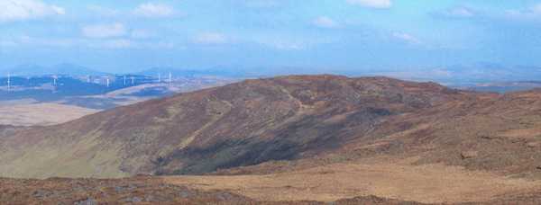
Approach from the west
Summary created by Colin Murphy
2011-05-17 11:18:13
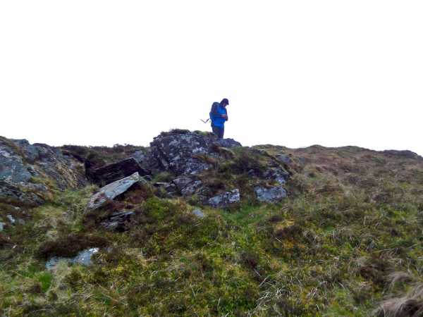
Picture: Rocky outcrop on summit
There is room for one car at A (V036 698), at the entrance to a short farmhouse track. Directly across the road another track leads to the NE, although you will need to cross several gates. After 500m at point B (V038 702) this forks. Take the track to the left which becomes a meandering forest trail. Continue up this for 1km until the forest ends and the open hillside appears at C (V050 707). Turn to the east, following the forest line which then swings to the SSE - a track runs alongside the forest line but it is completely impassable in places so you are advised to walk alongside this through heather. You will also need to cross several highly irritating barbed wire fences. You will reach the open hillside at D (V054 704) with Carran Far North ahead of you 400m to the SE, which must be traversed to reach the NE Top. The climb here becomes fairly steep over the next few hundred metres. The approach to this summit is marked by several large rocky outcrops and the top itself features a small pile of stones atop a small bump of rock and peat. Continue from this point directly to the SE, crossing several more barbed wire fences. The terrain dips down to approx 480m altitude after 1km, before rising, not too steeply again at point E (V065 697). Continue to the SE from there for 400m to attain the summit, which is marked by a long, narrow, rocky outcrop topped by a small pile of rocks. Time to summit from car, 2 hours approx.
If you are approaching from the west (road south of Knockanuha) please do not park on the corner at F (W04199 68795) (junction of road and track), the farmer(who likes walkers) has told me that people park there and delivery trucks can't get up the road and on occasion he's had to follow walkers up the mountain to get the keys to move their car: please park in the farm yard of the first little cottage. Linkback: mountainviews.ie/summit/340/comment/14934/
Use of MountainViews is governed by conditions and a privacy policy.
Read general information about the site. Opinions in material here are not necessarily endorsed by MountainViews.
Hillwalking is a risk sport. Information in comments, walks, shared GPS tracks or about starting places may
not be accurate for example as regards safety or access permission. You are responsible for your safety and your permission to walk.
See the credits and list definitions.


 Our Facebook page.