This website uses cookies, which are small text files that the website puts on your device to facilitate operation. Cookies help us provide a better service to you. They are used to track general user traffic information and to help the website function properly.
Feature count in area: 62, by county: Cork: 45, Kerry: 24, of which 7 are in both Cork and Kerry,
OSI/LPS Maps: 78, 79, 85, 86, 88, 89
Highest Place: Knockboy 704.8m
Starting Places (47) in area West Cork Mountains: Barley Lake North, Barrboy, Caha Pass, Carranmore, Carrigacappeen, Carriganass Castle, Castle Donovan Car Park, Clearagh House, Coolkellure House, Coomhola Bridge, Corrigatirra, Cousane Gap, Cummer Lough East Road, Derreencollig Wood, Esk Boreen, Fuhiry Wood, Garinish Island Pier, Glasagarav River Bridge, Glasnacummeen Stream, Glengarriff, Glengarriff Nature Reserve CP, Gorteeniher Drimoleague Heritage Walk CP, Gortloughra River Road, Gougane Barra Oratory, Gougane Barra Park CP, Grousemount Wind Farm, Kealkill Village, Knockanuha, Knockbrack South, Lough Atooreen N, Lough Nambrackderg North, Lough Nambrackderg Wood, Lough Nambreacdearg, Mealagh Bridge, Molly Gallivan's Visitor Centre, Nowen Hill West Road, Owvane River Bridge, Pookeen North Top Road, Pooleen Wood Car Park, Priests Leap, Reenroe Bridge, River Roughty, Shandrum Concrete Silo, Sillahertane Stream, Slaheny River Horseshoe, Top of Coom, Turner's Rock Tunnel
Summits & other features in area West Cork Mountains: Cen: Maughanaclea: Maughanaclea Hills East Top 470m, Maughanaclea Hills West Top 452m Cen: Shehy More: Shehy More 545.6m, Shehy More SW Top 446m E: Clearagh: Clearagh Hill 287m E: Currane: Currane Hill 228m N Cen: Douce: Douce Mountain 476m, Doughill Mountain 471m N: Carran: Barnastooka 497m, Bealick 537m, Carran 604m, Carran Far NE Top 561m, Carran Far North Top 506m, Carran NE Top 555m, Carran South Top 567m, Knockantooreen 450m N: Conigar: Conigar 566m, Conigar SW Top 566m, Foilastookeen 540m N: Coomataggart: Carrigalougha 423m, Coomataggart 530m, Coomataggart SW Top 509m, Derrineanig 304m, Lackabaun 472m, Mweelin 487m NE Cen: Carrigarierk: Carrigarierk 343m NW: Barraboy: Barraboy Mountain 460m, Barraboy Mountain Far East Top 456m, Barraboy Mountain SE Top 409m, Derroograne 468m, Turners Rock 420m NW: Knockboy: Caoinkeen 692.8m, Caoinkeen South-East Top 553.5m, Coomhola Mountain 472m, Knockboy 704.8m, Knockboy North Top 651.2m, Knockboy South Top 533.3m, The Priest's Leap 519m NW: Knocknamanagh: Bird Hill 412m, Coomclogherane Top 449m, Gullaba Hill 603m, Knockbrack 440m, Knockbrack South Top 458m, Knocknamanagh 637m, Knocknamanagh NE Top 625m S Cen: Dunmanway Hills: Cashloura 296.8m, Coolsnaghtig 295.8m, Inchanadreen 310m S Cen: Nowen: Milane Hill 354.4m, Mullaghmesha 494.3m, Nowen Hill 535.2m, Nowen Hill Far West Top 405.2m, Nowen Hill SW Top 509m, Pookeen North Top 319m S: Leap Hills: Carrigfadda 311.7m, Killeigh Hill 229m, Knockarudane Hill 169m, Knockscagh 195m S: Skibbereen: Barryroe Hill 156m, Lick Hill 158m W Cen: Knockbreteen: Knockbreteen 239m W: Bantry: Knocknaveagh 282m
Note: this list of places may include island features such as summits, but not
islands as such.
Conigar, 566mMountain An Coinigéar A name in Irish,
Place Rating ..
(Ir. An Coinigéar [OSI], 'the warren')Maolach an extra name in Irish, Cork County in Munster province, in Arderin Lists, An Coinigéar is the 373rd highest place in Ireland.
Grid Reference W06636 63874,
OS 1:50k mapsheet 85 Place visited by: 81members, recently by: mountainmike, DeirdreM, jlk, CusackMargaret, johncusack, a3642278, annem, Wilderness, Ulsterpooka, dodser, childminder05, eiremountains, Superterence, jackos, txantxangorri
I visited this place: NO (You need to be a logged-in member for this.)
Longitude: -9.35472, Latitude: 51.81988, Easting: 106636, Northing: 63874,
Prominence: 131m, Isolation: 1.2km ITM: 506606 563938 Bedrock type: Purple & green sandstone & siltstone, (Caha Mountain Formation) Notes on name: It seems that Conigar is the name applied to the south-western peak (566m) which overlooks Borlin, whilst Maolach, meaning 'bald hill', is the north-eastern peak overlooking Gougane Barra.
Short or GPS IDs, 6 char: Cngr, 10 char: Conigar Linkback: https://mountainviews.ie/summit/333/
Gallery for Conigar (An Coinigéar) and surrounds
Summary
for Conigar (An Coinigéar):
Simple climb, fine summit
Summary created by Colin Murphy
2015-06-22 10:47:33
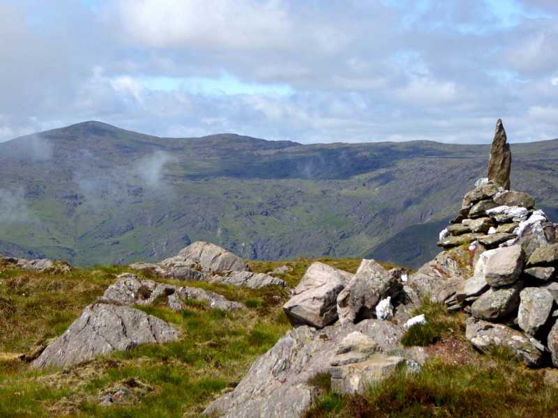
Picture: Summit with Caoinkeen SE in distance
There is just about room for a single car to park close to a double gate at A (W054 647), just north of Gowlane Bridge. Cross the gate and you will see a track to the right. Follow this for a few hundred metres until is vanishes on the open hillside. Continue east across a gently rising slope, over mostly shortish grass, the ground firm underfoot, at least in summer. Cross the small stream at B (W062 645) and turn SE, the ascent becoming steeper. You will encounter some large rock faces as you near the top, but these are generally easy to negotiate. The summit is marked by a small cairn topped by a pointy upright stone. Car to summit, 50 minutes. Great views in particular of Lough Nambrackderg set into the side of Caoinkeen SE Top to the west.
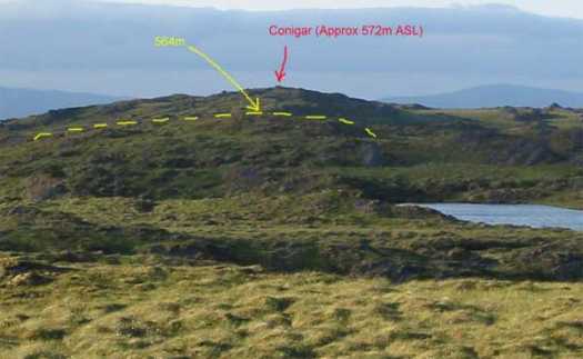
The summit of Conigar is NOT located at the point suggested here (C (W060 628)) (566m). If you look at the OS map closely, you can see a '570m' contour just underneath the 'ar' in the English spelling of Conigar. The Irish spelling obscures most of the contour detail and it is very easy to miss. Going by the shape of the summit, I would estimate that the correct height is probably about 572m. The correct location for the summit is D (W0664 6387). The attached photo shows the view back up the ridge from the incorrect summit of 566m. The yellow line shows the outline of the 564m hill in between and the true summit of Conigar is shown approx 1km to the NE. There are no features on the summit other than 2 small piles of stones on a rock. The easiest way to get to it is probably to take a short detour (1km) to the SW from Lough Glas if you are doing the Gougane Barra horseshoe walk. The ground is very wet with lots of pools to get around. It must be even worse in the Wintertime. The views from there and the false summit to the SW are very good with most of the mtns in West Cork visible as well as Bantry Bay and Sheeps Head. Linkback: mountainviews.ie/summit/333/comment/1761/
Read Less
Read More
Plenty of parking at W052 651
by billbaggins
7 Apr 2018
Plenty of parking available at DernColg Wd (W052 651) opposite a forest entrance and around 600 m from the gate at A (W054 647) mentioned by Colin Murphy Linkback: mountainviews.ie/summit/333/comment/19884/
Read Less
Read More
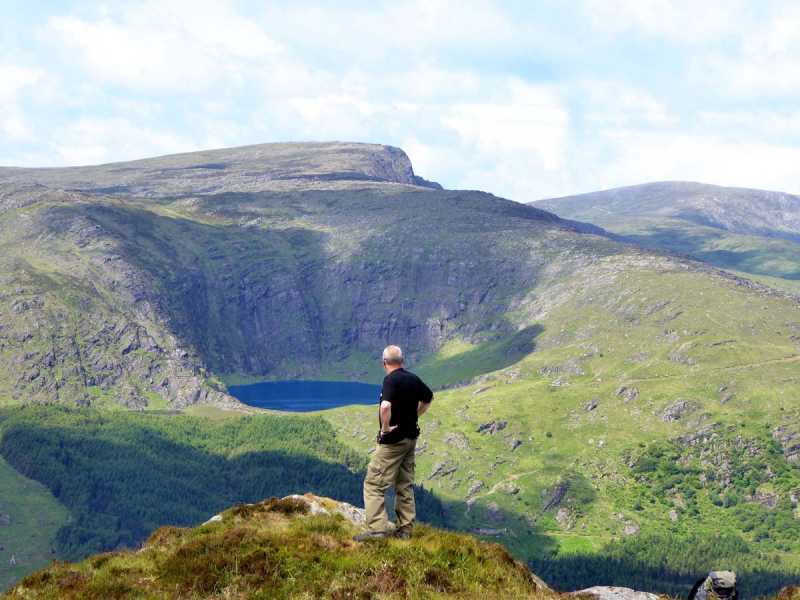
Picture: View to the west from near the summit
Top notch
by Colin Murphy
22 Jun 2015
Fine rocky summit with magnificent views to the west in particular. Pic shows Lough Nambrackderg cut into the side of Caoinkeen SE Top. Linkback: mountainviews.ie/summit/333/comment/18154/
Read Less
Read More
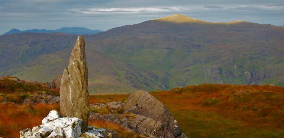
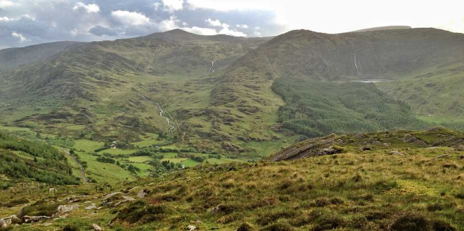
Picture: Early morning light on Knockboy
An early start, good weather rewarded with this view
Parked at E (W05344 63922) (one car - just). Walked back to the gate and straight up the hill for the peak. It's less than 1.5 hours up and back. Views from the top ok, but the nicest view is over the Borlin valley on the way back down. Pretty boggy at the start of the walk in June. Linkback: mountainviews.ie/summit/333/comment/15022/
Use of MountainViews is governed by conditions and a privacy policy.
Read general information about the site. Opinions in material here are not necessarily endorsed by MountainViews.
Hillwalking is a risk sport. Information in comments, walks, shared GPS tracks or about starting places may
not be accurate for example as regards safety or access permission. You are responsible for your safety and your permission to walk.
See the credits and list definitions.


 Our Facebook page.