This website uses cookies, which are small text files that the website puts on your device to facilitate operation. Cookies help us provide a better service to you. They are used to track general user traffic information and to help the website function properly.
Feature count in area: 34, all in Galway,
OSI/LPS Maps: 37, 44, EW-CON, MSW
Highest Place: Benbaun 729m
Starting Places (48) in area Twelve Bens: Angler's Return, Barr na nÓran Road, Ben Lettery Hostel, Bogville Road, Bridge St Clifden, Bundorragha Estuary Cross, Bunnageeha, Cannaclossaun, Connemara Mountain Hostel, Connemara National Park Visitor Centre, Dernasliggaun, Doire na bhFlann North, Doughruagh CP, Emlaghdauroe Bridge, Emlaghdauroe South, Fee Lough SW, Foher, Glasbeg Stream, Glashmore Bridge, Glencoaghan River Bridge, Glencraff Road End, Gleninagh River, Illaunroe North, Illaunroe South, Inaghbeg Path, Kylemore Abbey Exit, Kylemore River, Letterfrack Lodge, Lettergesh Beach, Lough Anivan Bend, Lough Auna S, Lough Fee East, Lough Nacarrigeen S, Lough Tanny, Muck Lough NW, Nambrackkeagh Lough, Owen na Baunoge River, Owengar Bridge, Owenglin River, Owenwee River, Pollacappul Lough E, Pollacappul Lough W, Shanvally, Skeaghatimull, Ten Bens Cottage, Tooreennacoona River, Western Way Cnoc na hUilleann, Western Way Inagh Cottages
Summits & other features in area Twelve Bens: Cen: Lough Auna Hills: Cregg 297m, Townaloughra East Top 216m Cen: Polladirk: Bencullagh 632m, Maumonght SW Top 454m, Diamond Hill 442m, Knockbrack 442m, Maumonght 602m E: Glencorbet: Benbaun 729m, Benbrack 582m, Benbaun 477m, Knockpasheemore 412m, Benfree 638m, Muckanaght 654m N: Doughruagh: Altnagaighera 549m, Benchoona 581m, Benchoona East Top 585m, Currywongaun 273m, Doughruagh 526m, Doughruagh South Top 525m, Garraun 598m, Garraun South Top 556m, Letterettrin 333m SE: Glencoaghan Loop: Bencollaghduff 696m, Benglenisky 516m, Benlettery 577m, Bencorr 711m, Bencorr North Top 690m, Bencorrbeg 577m, Binn an tSaighdiúra 653m, Benbreen 691m, Benbreen Central Top 680m, Benbreen North Top 674m, Derryclare 677m, Bengower 664m
Note: this list of places may include island features such as summits, but not
islands as such.
Garraun, 598mMountain Maolchnoc A name in Irish,
Place Rating ..
(Ir. Maolchnoc [TR], 'bald hill'), Galway County in Connacht province, in Arderin Lists, Garraun is the 295th highest place in Ireland.
Grid Reference L76708 61036,
OS 1:50k mapsheet 37 Place visited by: 163members, recently by: farmerjoe1, DSutherland, abbiew1001, TommyMc, BarnabyNutt, srr45, Carolineswalsh, jimmel567, ahogan, elizauna, annem, pcoleman, derekfanning, Superterence, fingalscave
I visited this place: NO (You need to be a logged-in member for this.)
Longitude: -9.862585, Latitude: 53.584858, Easting: 76708, Northing: 261036,
Prominence: 553m, Isolation: 0.6km ITM: 476676 761056 Bedrock type: Schists, grits, metavolcanics, mylonitic, (Ben Levy Grit Formation) Notes on name: Locally only the name Maolchnoc is used according to Tim Robinson, while the anglicised name Garraun marked on OS maps is no longer in use. There are several other hills in the area where the same discrepancy can be observed: Binn Fraoigh/Altnagaighera, Letter Hill/Tully Mountain. Garraun is clearly also a name of Irish origin. It may either be from Ir. garrán, 'grove', or, more likely, from Ir. géarán, 'fang'. The summit is flattish, but the eastern ridge leading to it is sharp enough to have deserved this name. If this suggestion is correct, the anomaly of two different Irish names for the peak is only an apparent problem, not a real one. The name Maolchnoc would aptly describe the rounded summit, while An Géarán would denote the sharp ridge descending to Lough Fee. Walks: see Paddy Dillon, Connemara, for routes approaching from the SE (45-50) and the NW (51-56).
Short or GPS IDs, 6 char: Garaun, 10 char: Garraun Linkback: https://mountainviews.ie/summit/281/
Gallery for Garraun (Maolchnoc) and surrounds
Summary
for Garraun (Maolchnoc):
Flat and Featureless Summit
Summary created by simon3, Onzy
2015-12-29 10:44:41
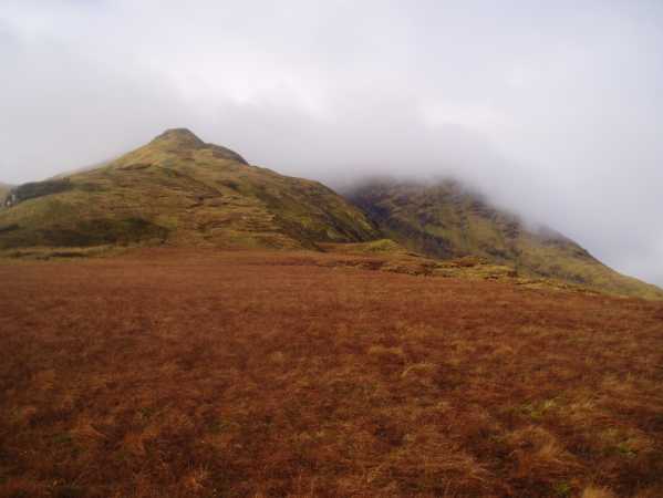
Picture: pic:fkaatje - Garraun false top
Garraun is situated in the less-visited northern half of the Twelve Bens, separated from the more prominent hills by the N59. A flat and featureless summit with two small cairns. It is unlikely to be climbed by itself but will more usually be combined with either or both of Benchoona and Garraun South Top.
There are a number of obvious routes; perhaps the most straight-forward way is from parking on the road at the southern end of Lough Fee (A (L804 596)) and heading north along a farm track skirting the western side of the lake. Just before the only inhabited house, head west, over a number of false tops to the summit.
A more challenging route begins from the northern end of Lough Fee (OwGar Br (L780 621)), and ascends the eastern spur of Benchoona before heading south to Garruan itself. This route is best left for a dry day with good visibility. It is also better for ascent than descent.
Garraun can also be reached from Lettergesh to the northwest ascending over Benchoona to the summit.
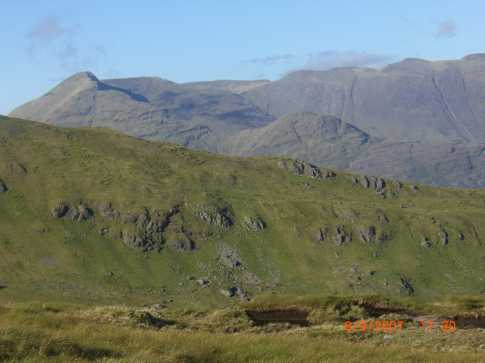
I climbed Garraun on 8th September 2007 using the ridge leading up from Lough Fee. It was a gloriously sunny day and the views in all directions were outstanding. There are a couple of false summits on this ascent which can be a bit disheartening if you aren't expecting them. As has been said before, the actual summit is a bit featureless but the beauty and solitude make this part of the Northern Bens well worth a visit. See the attached photo, taken from the southern side of the Lecknavarna valley which shows the ridge, with majestic Mweelrea in the top left background. Linkback: mountainviews.ie/summit/281/comment/2827/
Read Less
Read More
Picture: Eastern ridge to L Fee
gerrym on Garraun
by gerrym
2 Mar 2008
Approached from L Fee, first climbing up the steep grassy ridge to the summit of Benchoona. This is a varied and sizable top with a number of small loughs and cairns - in stark contrast with the top of Garraun which is non descript. There is a drop down to the SE to the col containing another small lough. There is a short climb to the summit of Garraun with its two small cairns a short distance apart. The only saving grace in the contrast with Benchoona are the views which open up even further. There are endless swathes of nothingness in the low ground beween the high mountains in every direction. The vista takes in the Bens, Partrys, Bengorm, Sheffreys and Mweelra with the Bens having the strongest magnetism. Descent was by the E ridge which drops down steeply. I dropped off onto the steep grassy ground heading down to L Fee, heading for an isolated house on the shore and followed a wall skirting around to the track leading to the car. Linkback: mountainviews.ie/summit/281/comment/2982/
Read Less
Read More
rain, mud and no views
by fkaatje
12 Feb 2012
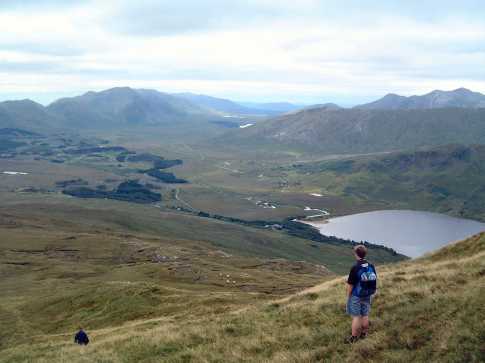
Climbed Garraun and Garraun South top on Saturday February 12th 2012. The weather forecast was for good bright spells with some showers, so I was hopeful for some good views. However halfway up Garraun ESE spur clouds and soaking rain descended on me and did not leave me alone until almost back at the car. Therefore I dropped my plans of including Benchoona and Binn Fhraoigh. I started from the church and followed the minor road along Lough Fee until its end at a house and a sheep pen. I entered the gate and climbed west towards the spur. There is a gate in the fence at B (L79265 60398) offering access to the spur. I followed up the spur aiming for the false summit at 480m (C (L77364 60924)) which blocks the actual summit of Garraun from view. Before the clouds descended I got a good view on the very steep neighbouring ridge up to Benchoona. Might be an option for a quick steep ascent, but not terrain I'd want to bother with on descent. The photo, which was taken at around 250m height, shows the fallse summit and part of the Benchoona ridge. The summit of Garraun is rather featureless apart from two small cairns. I had a bit of a challenge navigating my way to Garraun South due to the lack of visibility and the boggy/muddy terrain which was soaked by heavy overnight rain. Had to retrace my steps several times to avoid some very bad patches and steep slippery turf slopes. Same story for the first part of the descent from Garraun south. Descended through wet bogland and entered the road through a gate at D (L79191 58941). Have to return here on a fine day to take in the views. If you want to follow in my footsteps then download the gps trail at http://www.wikiloc.com/wikiloc/user.do?name=fkaatje. Linkback: mountainviews.ie/summit/281/comment/6681/
Read Less
Read More
CaptainVertigo on Garraun
by CaptainVertigo
6 Dec 2006
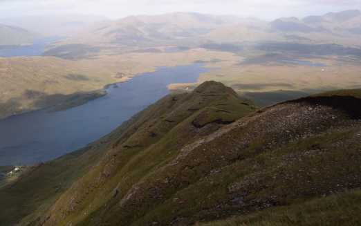
The so-called Northern Bens offer excellent returns for relatively little effort. In August 2006 my teenage sons and I followed the route suggested in WWI No.72 which involved parking near Creeragh Church on the Letterfrack to Leenane road (E (L802 594)), and walking along a boreen which runs roughly parallel to the south western shore of Lough Fee. Circa Fee L (L795 605), almost in front of a lonely but very much inhabited cottage turn left (westerly) and ascend the long spur that narrows as it heads for Garraun (598 m). It was a short hop across to Ben Choona and then back across Garraun to Binn Fhraoigh (of which more anon). Perhaps the most rewarding viewpoint was at the spot height marked 556 on Harvey's Map. During our time on the summits we saw the Renvyle peninsula with Tully Mountain to the west (and on to Inisbofin); Mweelrea and Killary to the north; to the east Lough Fee and the stately Turks; to the south Kylemore lake and the Twelve Bens. We descended another long spur (to the south of Lecknavarna river): the photo shows the great canvas of the northern Inagh Valley , bounded by the Turks and the Twelve Bens. When the Navan Trekkers arrived in Tully Cross for our October Weekend it was decided to repeat the route with all grades participating. Although the morning was wet the day cleared in time for the descent, and I was once again treated to the view in the photo. Linkback: mountainviews.ie/summit/281/comment/2572/
Read Less
Read More
simon3 on Garraun
by simon3
26 Dec 2003
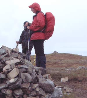
Garraun is roughly as exciting as Lemnaheltia. Which is to say that it is flattish and featureless. The photo shows the two small cairns on the summit. An easy way to get to Garraun is via a distinctive spur that stretches from the summit to the east. Linkback: mountainviews.ie/summit/281/comment/778/
Use of MountainViews is governed by conditions and a privacy policy.
Read general information about the site. Opinions in material here are not necessarily endorsed by MountainViews.
Hillwalking is a risk sport. Information in comments, walks, shared GPS tracks or about starting places may
not be accurate for example as regards safety or access permission. You are responsible for your safety and your permission to walk.
See the credits and list definitions.


 Add a Place Comment for Garraun, Maolchnoc


 Our Facebook page.