This website uses cookies, which are small text files that the website puts on your device to facilitate operation. Cookies help us provide a better service to you. They are used to track general user traffic information and to help the website function properly.
Feature count in area: 11, all in Cork,
OSI/LPS Maps: 79, 80
Highest Place: Musheramore 642.7m
Starting Places (8) in area Boggeragh Mountains: Butter Road, Duhallow Way, Derry Wood, Glannaharee East Woods S, Laharan Woods N, Millstreet Country Park, Mount Hillary Wood N, Mount Hillary Wood W, St John's Well
Summits & other features in area Boggeragh Mountains: Cen: Seefin: Knockcraugh 434m, Seefin 491m, Seefin East Top 491m N: Banteer: Mount Hillary 391m, Tooreen 322m NE: Bweeng: Bweeng Little 414m, Bweengduff 416m S: Macroom Hills: Burren 380m, Knockagreenan 263m W: Musheramore: Musherabeg 498.8m, Musheramore 642.7m
Note: this list of places may include island features such as summits, but not
islands as such.
Musheramore, 642.7mMountain Muisire Mór A name in Irish,
Place Rating ..
(Ir. Muisire Mór [OSI], 'great (mountain) of the Múscraige'), Cork County in Munster province, in Arderin, Vandeleur-Lynam Lists, Musheramore is the highest mountain in the Boggeragh Mountains area and the 209th highest in Ireland. Musheramore is the second most westerly summit in the Boggeragh Mountains area.
Grid Reference W32881 84999,
OS 1:50k mapsheet 79 Place visited by: 206members, recently by: Sweeney, rhw, oreills8, orlaithfitz, Petecal423, abcd, Baker_beauty, ToughSoles, markmjcampion, Leatra, PrzemekPanczyk, Arcticaurora, Ansarlodge, jackos, Krzysztof_K
I visited this place: NO (You need to be a logged-in member for this.)
Longitude: -8.978283, Latitude: 52.013481, Easting: 132882, Northing: 85000,
Prominence: 439m, Isolation: 2.3km, Has trig pillar
ITM: 532846 585059 Bedrock type: Red conglomerate, sandstone & mudstone, (Old Red Sandstone (undifferentiated)) Notes on name: Dinneen gives a longer, more poetic name for this mountain: Muisire na Móna Móire, 'Muisire of the great bog'. Móin Mhór was the old name for a chain of hills including the Boggeragh Mountains and Nagles Mountains. The element muisire does not appear elsewhere in Irish place-names. Judging by the late 16th century forms from maps, e.g. Knock Muskery, it appears to be connected with the Múscraige, who gave their name to the barony of Muskerry. It is on the NE edge of the ancient territory of this people. Mushera has two holy wells: one at the summit for sick animals and one on its northern slopes [St. John's Well] for humans, at which mass is celebrated at midsumer (Daphne Pochin Mould, 'Discovering Cork', p.22).
Short or GPS IDs, 6 char: Mshrmr, 10 char: Mshrmr Linkback: https://mountainviews.ie/summit/204/
Gallery for Musheramore (Muisire Mór) and surrounds
Summary
for Musheramore (Muisire Mór):
Butter roads and Kerrymens tables
Summary created by Peter Walker, jackill
2015-08-11 09:31:12
Musheramore is easily climbed from the car park at StJ Well (W320 856). Walk down the road for 200 meters or so towards Musherabeg and you'll meet a track turning into the woods on your left.. Follow this track through the trees gaining height all the time. The track joins the Duhallow way after a bit and you can follow this on a fairly good track around to Mushera where it ends.
There's nothing for it but to head out across the mountain making a direct line for the summit.
Its fairly easy going all the way in a series of long steps. About 400 meters from the summit a series of bogholes block your path, go around them rather than through or you will get very damp feet.
The summit is marked by a large beehive of a cairn(which seems to be the highest point), a trig pillar and a few crosses made from sticks.The most direct descent is towards Millstreet Forest park and then back along the road to the car park.
Mushermore is easily climbed from the car park at StJ Well (W320 856). Toddle on down the road for 200 meters or so towards Musherabeg and you'll meet a track turning into the woods on your left.. Follow this track
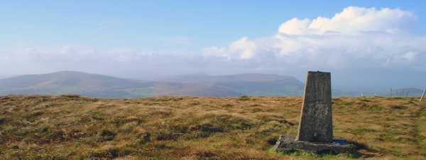
through the trees gaining height all the time. The track joins the Duhallow way after a bit and you can follow this on a fairly good track around to Mushera where it ends.There's nothing for it but to head out across the mountain making a direct line for the summit. Its fairly easy going all the way in a series of long steps. About 400 meters from the summit a series of bogholes block your path, go around them rather than through or you will get very damp feet. The summit is marked by a large beehive of a cairn(which seems to be the highest point), a trig pillar and a few crosses made from sticks.The most direct descent is towards Millstreet Forest park and then back along the road to the car park. Looking at the map near Musheramore you will see "Kerrymans Table crossroads".The Kerrymans table is a large flat rock where people rested and goods were collected situated on the Old Butter Road which was constructed in 1747.It is four miles from Millstreet on the road to Rylane exactly mid-way between Killarney and Cork City, 25 miles on either side. It is also about 25 miles from Castleisland, a significant market town for the farmers of Kerry in past times. If you were to look at a map you will notice that Castleisland, Millstreet and the top of Blarney Street in Cork city where the Butter Market was situated, form a straight line "as the crow flies." This photo shows the trig pillar on Musheramore looking across at Mullaghanish, Knocknagowan, and Caherbarnagh with the Paps behind. Where the steep face of Cahernarnagh drops down to meet the plain below marks the edge of a large fault line that runs from Mallow to Killarney, though it is difficult to see as much of it was covered by glacial deposits in the last ice age. Linkback: mountainviews.ie/summit/204/comment/2054/
Read Less
Read More
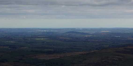
Picture: cork city and coast from mushera
rossbeighed on Musheramore
by rossbeighed
20 Mar 2009
taking the advice from the comments on this site I climbed Mushera from millstreet county park. Id always only ever climbed mushera from st johns well which was kind of boggy and heathery.
The ease at which I got to the top kinda suprised me (in comparison with st johns well) but then MCP is already at an elevation of over 1,000 feet even before you start. good views. on a clear day with binoculars or a TP lens you can see parts of cork city and the coast in the distance. Linkback: mountainviews.ie/summit/204/comment/3659/
Read Less
Read More
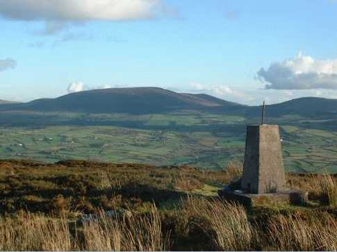
Picture: Musheramore seen from Claragh Mountain, both free of mist
Mushera and Claragh, weather forecasters
by pdtempan
4 Sep 2021
In this view Musheramore is seen from Claragh Mountain, a lower mountain also overlooking Millstreet. There is a local saying about the weather relating to these two mountains: 'Ceo ar Mhusire's Clárach lom, an comhartha soininne is fearr ar domhan.' ('Mist on Mushera and Claragh clear - the best sign of good weather in the world'). Linkback: mountainviews.ie/summit/204/comment/755/
Read Less
Read More
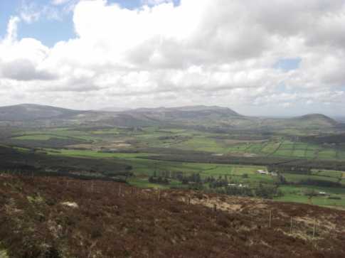
Picture: View from Duhallow Way
chelman7 on Musheramore
by chelman7
4 May 2008
A good walk if you use the Duhallow way rather than the Millstreet country park route. Views also better this way. Linkback: mountainviews.ie/summit/204/comment/3085/
Read Less
Read More
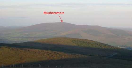
Picture: View of Musheramore from Mullaghanish
john_desmond on Musheramore
by john_desmond
7 Apr 2005
The picture shows a view of Musheramore as seen from Mullaghanish. Note the shoulder to the South (right) which makes Musheramore very easy to recognise from a number of angles. This is the closest 2000 ft mountain to Cork City and can be easily seen from high points near the city. It is a very easy climb, about 45 mins up and 35 mins back. Start at the Millstreet Country Park. Linkback: mountainviews.ie/summit/204/comment/1634/
Use of MountainViews is governed by conditions and a privacy policy.
Read general information about the site. Opinions in material here are not necessarily endorsed by MountainViews.
Hillwalking is a risk sport. Information in comments, walks, shared GPS tracks or about starting places may
not be accurate for example as regards safety or access permission. You are responsible for your safety and your permission to walk.
See the credits and list definitions.


 Our Facebook page.