This website uses cookies, which are small text files that the website puts on your device to facilitate operation. Cookies help us provide a better service to you. They are used to track general user traffic information and to help the website function properly.
Feature count in area: 34, all in Galway,
OSI/LPS Maps: 37, 44, EW-CON, MSW
Highest Place: Benbaun 729m
Starting Places (48) in area Twelve Bens: Angler's Return, Barr na nÓran Road, Ben Lettery Hostel, Bogville Road, Bridge St Clifden, Bundorragha Estuary Cross, Bunnageeha, Cannaclossaun, Connemara Mountain Hostel, Connemara National Park Visitor Centre, Dernasliggaun, Doire na bhFlann North, Doughruagh CP, Emlaghdauroe Bridge, Emlaghdauroe South, Fee Lough SW, Foher, Glasbeg Stream, Glashmore Bridge, Glencoaghan River Bridge, Glencraff Road End, Gleninagh River, Illaunroe North, Illaunroe South, Inaghbeg Path, Kylemore Abbey Exit, Kylemore River, Letterfrack Lodge, Lettergesh Beach, Lough Anivan Bend, Lough Auna S, Lough Fee East, Lough Nacarrigeen S, Lough Tanny, Muck Lough NW, Nambrackkeagh Lough, Owen na Baunoge River, Owengar Bridge, Owenglin River, Owenwee River, Pollacappul Lough E, Pollacappul Lough W, Shanvally, Skeaghatimull, Ten Bens Cottage, Tooreennacoona River, Western Way Cnoc na hUilleann, Western Way Inagh Cottages
Summits & other features in area Twelve Bens: Cen: Lough Auna Hills: Cregg 297m, Townaloughra East Top 216m Cen: Polladirk: Bencullagh 632m, Maumonght SW Top 454m, Diamond Hill 442m, Knockbrack 442m, Maumonght 602m E: Glencorbet: Benbaun 729m, Benbrack 582m, Benbaun 477m, Knockpasheemore 412m, Benfree 638m, Muckanaght 654m N: Doughruagh: Altnagaighera 549m, Benchoona 581m, Benchoona East Top 585m, Currywongaun 273m, Doughruagh 526m, Doughruagh South Top 525m, Garraun 598m, Garraun South Top 556m, Letterettrin 333m SE: Glencoaghan Loop: Bencollaghduff 696m, Benglenisky 516m, Benlettery 577m, Bencorr 711m, Bencorr North Top 690m, Bencorrbeg 577m, Binn an tSaighdiúra 653m, Benbreen 691m, Benbreen Central Top 680m, Benbreen North Top 674m, Derryclare 677m, Bengower 664m
Note: this list of places may include island features such as summits, but not
islands as such.
Muckanaght, 654mMountain Mucanacht A name in Irish,
Place Rating ..
Ir. Mucanacht [logainm.ie], meaning obscure, or Meacanacht [TR], 'hill like a pig's back’Meacanacht an extra name in Irish, Galway County in Connacht province, in Arderin, Vandeleur-Lynam, Irish Best Hundred, Irish Highest Hundred Lists, Mucanacht is the 190th highest place in Ireland.
Grid Reference L76783 54084,
OS 1:50k mapsheet 37 Place visited by: 281members, recently by: Juanita, CaminoPat, Daingean, rhw, Prem, Carolineswalsh, ConMack23, Chopper, Ansarlodge, SFlaherty, Lyner, andalucia, Kirsty, Carolyn105, Kaszmirek78
I visited this place: NO (You need to be a logged-in member for this.)
Longitude: -9.85858, Latitude: 53.522468, Easting: 76783, Northing: 254084,
Prominence: 179m, Isolation: 1km ITM: 476760 754107 Bedrock type: Psammitic pelitic & semi-pelitic schists, (Streamstown Schist Formation) Notes on name: There are several other place-names with Muiceanach (pig-like) in Connemara (e.g. Muiceanach Choille and Muiceanach Idir Dhá Sháile). This element is found mainly in Connacht and refers to a hill or ridge shaped like a pig's back. It is possible that Mucanacht is a variant of this. Previously Meachanach in MV.
Short or GPS IDs, 6 char: Mckngh, 10 char: Muckanaght Linkback: https://mountainviews.ie/summit/182/
Gallery for Muckanaght (Mucanacht) and surrounds
Summary
for Muckanaght (Mucanacht):
A remote, steep and grassy peak - part of many long circuits.
Summary created by markmjcampion, jackill, scapania
2021-04-18 13:05:55
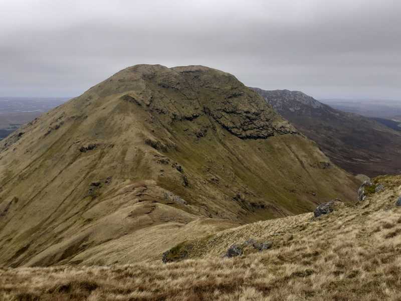
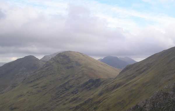
Picture: Muckanaght from the East
Muckanaght is a grassy, craggy steep cone at the head of three valleys. It's well tucked away and requires a good level of fitness and ability on steep ground. The great views includes some neighbouring bens, Diamond and Tully hills, Mweelrea, Ben Gorm and the Sheffreys.
It's usually tackled as part of a circuit of either the Glencorbet, Owenglin or Polladirk valleys, but it can also be climbed directly. All routes involve at least 5-6 hrs up and down.
NE. Park with care in Glencorbet, just after the bridge at KylmorRv (L79914 57378). As of Apr '21 there aren't many parking options so, if you're stuck, call to one of the houses for permission.
Walk up the road until a wide track heads off to the left. Follow this track into the glen and across the Kylemore River from where you have options – head first for Benbaun or Benfree or either of the two cols at A (L78044 54293) or B (L77344 54217). Once you reach the col between B'free and M, climb v steeply to the W to attain the summit.
SW. From Owenglin valley, park at C (L74378 51283). Head E along forest trails, breaking out into open country at approx. D (L76675 52709). Go steeply N up the valley to E (L76208 53989) and from here it's an easy walk to the summit.
N. From Benbrack be advised that the N slopes are v steep and craggy and would be v challenging in rain and mist.
E. The approach from Benfree is a lot easier although still steep.
Notable tracks incl. track/2440, track/1454 track/1710, the latter involving 23k and 2,000 ascent.
This impressive mountain, also known as Muckanaght, would be passed in a number of circuits such as the horseshoe walks around the Owenglin or Polladirk Rivers.
As you can see in the picture there is an extensive view of coastline near Letterfrack. On the coastline, just right of centre, is Tully Mountain (356m). Below and to its right in shadow is Diamond Hill.
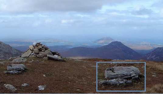
The summit of this mountain, and the area immediately around it, is composed of schist rather than the quartzite that so much of the rest of the 12 Bens are made of. You can see a single piece of white quartzite on top of the cairn which is otherwise the darker shist. The inset shows one of the pieces of schist in more detail.
This summit attracted the attention of Robert Lloyd Praeger. "The schists ... as on the summit of Muckanaght (2153 feet), and forming as they do a much more hospitable habitat for plant than the barren quartzite, they attract the comparitively few alpine plants of the range - Mountain Meadow-rue, Purple Saxifrage, Mountain Sorrel, Mountain Sawwort, Dwarf Mountain Willow, Holly Fern, and others." Linkback: mountainviews.ie/summit/182/comment/700/
Read Less
Read More
simon3 on Muckanaght
by simon3
9 Oct 2003
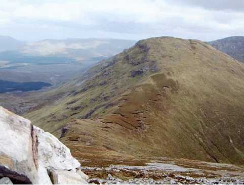
This picture shows Muckanaght from the west. The left of the mountain is its northern slope which becomes very steep in parts, particularly to the east. HC Hart [Climbing in the British Isles: Ireland 1895] wrote "The most interesting climb is upon the north of Muckanaght (2,150ft.), which is connected to Benfree by a ridge at about 1,000ft. The cliffs lie about 1,300 to 1,800 ft., and from near their upper edge to the summit (2,150ft.) is a steep and perilous grassy slope." While perfectly possible (at least in daylight), it’s hard to ascend Muckanaght from that side. For a party not comfortable with steep grassy slopes there’s an alternative: go to the col between Muckanaght and Ben Fhraoigh (Benfree, behind the summit in this picture) and climb the slightly less steep ridge to the summit. Linkback: mountainviews.ie/summit/182/comment/701/
Read Less
Read More
csd on Muckanaght
by csd
29 Dec 2003
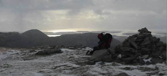
The summit cairn on Meacanach and the view to the west on a snowy December 28th, 2003. We gained the summit of Meacanach from the Kylemore River in Glencorbet via the col just south of Maumnascalpa (marked on the Harvey map). The summit is a fairly steep slog up from the valley, and care should be taken when the ground is slippy underfoot. Once at Meacanach, Bin Fraoigh and Binn Bhan are easily accomplished. Full-size versions of this and other pics will be uploaded as usual to http://www.202degrees.com/mountains. Linkback: mountainviews.ie/summit/182/comment/780/
Read Less
Read More
bryanmccabe on Muckanaght
by bryanmccabe
16 Dec 2009
Muckanaght is one those mountains I wanted to climb just based on its name alone, and it didn't disappoint! About 2.5km on the Clifden side of Ben Lettery youth hostel, there's a road heading north towards the Owenglin River. Immediately after crossing the river on a narrow bridge, there's a parking area at the entrance to a forest. We walked through the forest to the end, out into the open valley before climbing to the saddle between Muckanaght and Benfree. A left turn leads to the summit of Muckanaght over a few steep grassy sections. Views from the top are spectacular. Continued on over Bencullagh to Maumonght and down to the road again via Maumonght SW top. Muckanaght is a very prominent mountain, and is arguably at its most impressive when viewed from the valley of the Kylemore River looking west. Linkback: mountainviews.ie/summit/182/comment/4254/
Whether you're thinking of tackling the entire Owenglin Circuit, or just a bit of it, your preparations will be greatly enhanced (and much more enjoyable) if you watch this 15 minute YouTube classic by Martin Critchley and Sharron Schwartz
Let me quote from the YouTube intro:
"This tough 23 km circuit in the 12 Bens of Connemara in County Galway offers some of the best hillwalking in Ireland. Steep quartzite peaks tower over valleys of vivid green and pink bog-land inset with serpentine rivers and deep blue lakes. Beyond, the ragged coastline with ribbons of yellow sand is washed by the restless Atlantic Ocean. This 12 summit circuit will take in the region of 12 hours to complete and involves a climb of over 2,000m ascent. It is not for the faint hearted and will require high levels of fitness and navigational proficiency, especially in poor weather conditions. It is best tackled in the long hours of daylight during the summer months."
I think that this is one of our best mountain movies.
Use of MountainViews is governed by conditions and a privacy policy.
Read general information about the site. Opinions in material here are not necessarily endorsed by MountainViews.
Hillwalking is a risk sport. Information in comments, walks, shared GPS tracks or about starting places may
not be accurate for example as regards safety or access permission. You are responsible for your safety and your permission to walk.
See the credits and list definitions.


 Our Facebook page.