This website uses cookies, which are small text files that the website puts on your device to facilitate operation. Cookies help us provide a better service to you. They are used to track general user traffic information and to help the website function properly.
Feature count in area: 115, by county: Wicklow: 108, Kildare: 4, Wexford: 2, Carlow: 3, of which 1 is in both Wexford and Wicklow, of which 1 is in both Carlow and Wicklow,
OSI/LPS Maps: 28B, 55, 56, 61, 62, AWW, EW-DM, EW-LG, EW-WE, EW-WS
Highest Place: Lugnaquilla 924.7m
Starting Places (205) in area Wicklow: 1916 Memorial Car Park, Aghavannagh Ow Bridge, Aghowle Wood, Altidore Wood Entrance, Annacurra National School, Annalecka Bridge, Asbawn Brook L8350, Aughrim National School, Ballard Road, Ballinabarny Gap, Ballinagappoge Bridge Layby, Ballinagappoge Mountain Hairpin, Ballinagore, Ballinahinch Wood, Ballinastoe MBT CP, Ballinastraw South, Ballineddan Upr Fork, Ballinfoyle Upr Cross, Ballycoog, Ballycreen Brook Bridge, Ballycumber, Ballycumber Bridge, Ballycumber Lane, Ballycumber Wicklow Way, Ballylerane, Ballylow Bridge, Ballylusk Quarry, Ballymanus Lane, Ballymoyle Shooting Lodge, Ballynultagh Gap, Ballynultagh Lane, Ballyreagh Wood, Ballyross Forest, Ballysmuttan Long Stone, Baravore, Barnbawn South, Barranisky North, Barranisky West, Bohilla Land Roundabout, Bohilla Lane Mid, Boranaraltry Bridge, Bray Harbour, Brewel West, Brittas Bay North CP, Buckroney Sand Dunes CP, Bus Terminus, Camera Hill Track Cross, Castletimon Wood North, Clara Vale, Clone House Road, Clonegal, Cloon Wood Cp, Coate Bridge, Coolballintaggart Ledge, Coolbawn House Lane, Cransillagh Brook , Crone Wood CP, Crossbridge, Crossoona Rath, Cummer Wood South, Curtlestown Wood CP, Deputy's Pass CP, Derralossary Church, Derry River Bridge, Devil's Glen CP, Devil's Glen Wood, Djouce Wood Calary, Djouce Wood Lake, Djouce Wood Long Hill, Donard, Donnelly's Lane Car Sales, Drumgoff Forest, Dunranhill North, Dunranhill SE, Dunranhill South, Dwyer McAllister Cottage CP, Enniskerry, Fentons Pub, Fitzsimons Park GAA, unuseableFlemings Footbridge Glen Rd, Gap Pub, Gap Road, Glen Beach CP, Glen of the Downs CP, Glenbride Lane, Glenbride Lodge, Glencree Reconciliation, Glendalough, Glenealy GAA, Glenmacnass Tonelagee CP, Glenmalure Hostel, Glenmalure Lodge, Glenmalure Waterfall, Glenview Hotel, Gowle House, Great Sugar Loaf CP, Grove Bar, Heffernans Well Wood, Hill View, Hollywood Glen, JB Malone CP, Johnnie Fox Pub, Keadeen NE trail, Keadeen Trailhead, Kevins Way Footbridge, Kilbride Army Camp Entrance, Kilcandra South, Kilcommon View, Killalongford Wood, Kilmacrea Cross Roads, Kilranelagh House Gate, Kilruddery Car Park, Kilruddery Cottages, Kings River, Kippure Bridge, Kippure Estate, Kippure Transmitter Gate, Knickeen Cross, Knocknaboley Lane Leeraghs Bog, Knocknaboley Lane Stone Cottage, Knockrath Little, Knockree west, Kyle Loop North, Lackan Wood S, Lake Dr Fraughan Brook, Lake Drive, Lake Park Cross, Lake View Pub, Laragh Free Car Park, Laragh NSch, Lead Mines CP, Liffey Bridge, Liffey Head Bridge, Lough Bray Lower, Lough Bray Upper, Lough Tay North Viewing Point, Lough Tay Wicklow Way CP, Luglass Lane L97561, Lugnagun Track, Macreddin Village, Mangans Lane, Military Road Carrigshouk Hill, Military Road Inchavore River Nth, Military Road Inchavore River Sth, Military Road NW Lough Tay, Military Road Ballyboy Bridge, Military Road Cloghoge Brook, Military Road Croaghanmoira, Military Road Fananierin, Military Road LaraghWicklow Way, Military Road Slieve Maan, Monspolien Bridge, Moortown House, Mountain Rescue HQ, Muskeagh Little Wood, Nahanagan Lough NE, Novara Avenue, Bray, Oiltiagh Brook Knickeen, Old Bridge Cross, Old Bridge Scouts , Old Wicklow Way entrance, Paddock Hill SE, Pier Gates CP, Powerscourt Waterfall CP, Putland Road, Quintagh East, Raheen Park CP, Raheenleagh East, Railway Walk CP, Rathdrum Railway Station, Rednagh Wood, Rocky Valley, Roundwood, Sally Gap, Sally Gap N, Seefin Trailhead, Seskin SE, Shankill Tributary Bridge, Shay Elliott, Sheepshanks Bridge, Shillelagh, Slievecorragh Track, Slievefoore South, Sraghoe Brook, St John's Church, St Kevins Chair, St Kevins Church, St Kevins Way R756, Stone Circle Bridge, Stookeen South, Stranahely Wood, Stranakelly Cross Roads, Tallyho, Templeboden, Tithewer, Tomcoyle Lower, Tomriland Wood, Toor Brook, Trooperstown Hill Access, Turlough Hill CP, Upper Lake CP, Vallymount GAA CP, Vartry Reservoir Upper, Zellers Pub
Summits & other features in area Wicklow: Cen: Glendalough North: Brockagh Mountain 556.9m, Brockagh Mountain NW Top 549.5m, Brockagh Mountain SE Top 471.7m, Camaderry East Top 677.3m, Camaderry Mountain 698.6m, Conavalla 734m, Tomaneena 682.4m Cen: Glendalough South: Carriglineen Mountain 456.6m, Cullentragh Mountain 510m, Derrybawn Mountain 476.1m, Kirikee Mountain 474.5m, Lugduff 653.2m, Lugduff SE Top 638m, Mullacor 660.7m, Trooperstown Hill 430m N Cen: Tonelagee: Carrignagunneen 561m, Fair Mountain 571.2m, Stoney Top 713.7m, Tonelagee 815.8m, Tonelagee E Top 668m, Tonelagee South-East Top 545.8m NE: Bray & Kilmacanogue: Bray Head Hill 238.9m, Carrigoona Commons East 242m, Downs Hill 372.9m, Great Sugar Loaf 501.2m, Little Sugar Loaf 342.4m NE: Djouce: Djouce 725.5m, Knockree 342.1m, Maulin 570m, Tonduff 642m, Tonduff East Top 593m, War Hill 684.8m, White Hill 631.1m NE: Fancy: Ballinafunshoge 480m, Kanturk 527.4m, Knocknacloghoge 532.4m, Luggala 593.3m, Robber's Pass Hill 508.9m, Scarr 640m, Scarr North-West Top 559.8m, Sleamaine 430m NE: Vartry: Ballinacorbeg 336m, Ballycurry 301m, Dunranhill 342m, Mount Kennedy 365.9m NW: Blessington: Carrigleitrim 408m, Lugnagun 446.2m, Slieveroe 332m, Sorrel Hill 599.5m NW: Mullaghcleevaun: Black Hill 602.2m, Carrigshouk 572.5m, Carrigvore 682.4m, Duff Hill 720.8m, Gravale 719m, Moanbane 703m, Mullaghcleevaun 846.7m, Mullaghcleevaun East Top 796m, Silsean 698m S: Aughrim Hills: Cushbawn 400m, Killeagh 249m, Moneyteige North 427m, Preban Hill 389m S: Croaghanmoira: Ballinacor Mountain 529.3m, Ballycurragh Hill 536m, Ballyteige 447m, Carrickashane Mountain 508m, Croaghanmoira 662.3m, Croaghanmoira North Top 579.5m, Fananierin 426m, Slieve Maan 547.8m, Slieve Maan North Top 546.1m S: Croghan Kinsella: Annagh Hill 454m, Croghan Kinsella 606m, Croghan Kinsella East Top 562.1m, Slievefoore 414m S: Shillelagh Hills: Lakeen 357m, Monaughrim 206m, Seskin 344m, Stookeen 420m S: Tinahely Hills: Ballycumber Hill 429.7m, Eagle Hill 296m, Muskeagh Hill 398.2m SE: Wicklow South East: Ballinastraw 284m, Ballyguile Hill 188m, Barranisky 280m, Carrick Mountain 381m, Collon Hill 238m, Kilnamanagh Hill 217m, Westaston Hill 270m W: Baltinglass: Ballyhook Hill 288m, Baltinglass Hill 382m, Carrig Mountain 571m, Carrigeen Hill 298m, Cloghnagaune 385m, Corballis Hill 258m, Keadeen Mountain 653m, Spinans Hill 409m, Spinans Hill SE Top 400m, Tinoran Hill 312m W: Cen Lugnaquilla: Ballineddan Mountain 652.3m, Benleagh 689m, Camenabologue 758m, Camenabologue SE Top 663m, Cloghernagh 800m, Corrigasleggaun 794.6m, Lugnaquilla 924.7m, Slievemaan 759.7m W: Donard: Brewel Hill 222m, Church Mountain 544m, Corriebracks 531m, Lobawn 636m, Slievecorragh 418m, Sugarloaf 552m, Table Mountain 701.7m, Table Mountain West Top 563m
Note: this list of places may include island features such as summits, but not
islands as such.
Tonelagee E Top, 668mMountain Tóin le Gaoith (mullach thuaidh) A name in Irish,
Place Rating ..
For origin of name, see Tonelagee., Wicklow County in Leinster province, in Arderin Beg, Vandeleur-Lynam Lists, Tonelagee E Top is the 164th highest place in Ireland.
Grid Reference O09568 01887,
OS 1:50k mapsheet 56 Place visited by: 661members, recently by: ccartwright, StephenM07, RosieMc, farmerjoe1, Nailer1967, marymac, Padraigin, jackos, MeabhTiernan, Aidy, rhw, Courin, knightsonhikes, taramatthews, maoris
I visited this place: NO (You need to be a logged-in member for this.)
Short or GPS IDs, 6 char: TnlgET, 10 char: TnlgETop Linkback: https://mountainviews.ie/summit/159/
Gallery for Tonelagee E Top (Tóin le Gaoith (mullach thuaidh)) and surrounds
Summary
for Tonelagee E Top (Tóin le Gaoith (mullach thuaidh)):
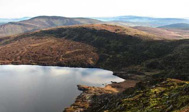
Sitting above Lough Ouler
Summary created by wicklore
2013-08-24 08:16:09
Picture: Tonelagee NE Top
One approach is from near the Glenmacnass Waterfall on the military road (R115). There is a car parking area at GlMacnas (O11400 03000) with room for several cars, but be warned that car break-ins are becoming increasingly common in the parking areas of the Dublin /Wicklow mountains.
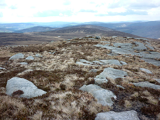
Cross the river and head SW up the spur leading to Tonelagee NE Top. This is a relatively gentle 2.3km slope to the summit. The top is a large flat area with no clearly defined summit and a number of large peat hags.
Another approach is from the Wicklow Gap TurL Hl (O0752 0017) from which it is a simple though stern climb first to Tonelagee before making your way to the NE Top.
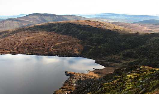
Tonelagee NE Top sits above Lough Ouler, a nice heart shaped lake. Other views include the main Tonelagee summit, together with the flat profile of the reservoir on Turlough Hill and the long line of the Camaderry ridge leading down to Glendalough.
Picture: Looking S to the Brockaghs from Tonelagee NE Top
A long but gentle climb.
by Harry Goodman
14 May 2010
As I had an opportunity on Mon 10 May 2010 to do some hill walking I decided to climb Tonelagee NE Top as it was the nearest, to Dublin, of four 600m tops in Dublin/Wicklow that I had not, as yet, climbed. I started from the parking area GlMacnas (O11400 03000) off the R115 just N of the Glenmacnass Waterfall by crossing the river and heading SW up the spur leading to Tonelagee NE Top. Although a track is marked on the Harvery's Wicklow Map, and I was able to pick it out from time to time, in the end I more or less made my way directly to the top up a fairly gentle slope of heather and grass for some 2.3km. The top is a large flat area with no clearly defined summit and a number of large peat hags. The sharp face of Tonelagee dominates the skyline directly to the SW, together with the flat profile of the reservoir on Turlough Hill and the long line of the Camaderry ridge leading down to Glendalough. As I did not want to simply descend by the same route I decided instead to make for Brockagh Mountain and Brockagh Mountain SE Top before looping back down to the R115 and walking up the road past the Glenmacknass Waterfall to my start point , a total round of some 12.5km. For further information on my extended route see my comments on Brockagh Mountain. Linkback: mountainviews.ie/summit/159/comment/4732/
Read Less
Read More
Picture: Tonelagee NE Top towers over Lough Ouler.
simon3 on Tonelagee E Top
by simon3
5 Feb 2007
Lough Ouler, heart shaped lake in the centre of Wicklow rests at the foot of Tonelagee and is cradled by the boggy ridge that Tonelagee NE Top on one side and to the north a smaller, unnamed ridge. As mneary34 says, it is more likely to be visited en route to somewhere else than for any other reason.
This is a handy one to bag on the way to Tonelagee, but it is so nondescript that many a walker has by-passed it without realising it is a top in itself. The summit is a broad, grassy area with no marking and its prominence is barely distinguishable from the surrounding landscape. I did it as the first stop in a loop also taking in Tonelagee and Stoney Top Linkback: mountainviews.ie/summit/159/comment/18863/
Read Less
Read More
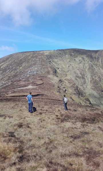
Picture: View to Tonelagee from Tonelagee NE
Onwards and upwards
by Bunsen7
28 Mar 2017
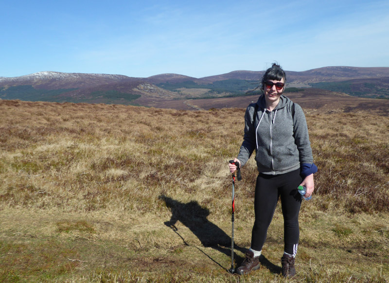
Most of the pictures uploaded rightly focus onview across the lake. This shows walkers assessing the route onwards to Tonelagee. Linkback: mountainviews.ie/summit/159/comment/18865/
Use of MountainViews is governed by conditions and a privacy policy.
Read general information about the site. Opinions in material here are not necessarily endorsed by MountainViews.
Hillwalking is a risk sport. Information in comments, walks, shared GPS tracks or about starting places may
not be accurate for example as regards safety or access permission. You are responsible for your safety and your permission to walk.
See the credits and list definitions.


 Add a Place Comment for Tonelagee E Top, Tóin le Gaoith (mullach thuaidh)


 Our Facebook page.