This website uses cookies, which are small text files that the website puts on your device to facilitate operation. Cookies help us provide a better service to you. They are used to track general user traffic information and to help the website function properly.
Feature count in area: 24, by county: Kerry: 12, Cork: 14, of which 2 are in both Cork and Kerry,
OSI/LPS Maps: 79
Highest Place: The Paps East 694m
Starting Places (28) in area Derrynasaggart: Carrigallisy, Clonee, Dromiscane Castle, Fuhiry Wood, Garrane Bridge, Garries Bridge, Glannafreaghaun Lough N, Glannafreaghaun Lough S1, Glannafreaghaun Lough S2, Gortavehy Lough, Grousemount Wind Farm, Inchamore Woods N, Inchamore Woods W, Kippagh Lough, Knocknabro Wood, Knockullane, Liam Hegarty Monument, Loo River Junction, Lough Murtagh, Millstreet, Mullaghanish Transmitter Gate, Old Rail Level Crossing, Paps Walk S, River Roughty, Rossacroo na Loo Forest, Sillahertane Stream, The Mills Inn, Top of Coom
Summits & other features in area Derrynasaggart: Cen: Knocknabro: Knocknabro East Top 530m, Knocknabro NE Top 535m, Knocknabro West Top 592m, Knocknagowan 574m N: Caherbarnagh: Caherbarnagh 681m, Caherbarnagh East Top 549m, Caherbarnagh NW Top 668m, Claragh Mountain 452m, Curracahill 478m SE: Mullaghanish: Ballyvouskill 401m, Knockacommeen 426m, Knockullane 462m, Knockullane East Top 408m, Mullaghanish 649m, Mullaghanish North-East Top 586.4m, Mullaghanish Far North-East Top 558.5m SW: Coomagearlahy: Knockbwee 461m, Cummeenboy 442m, Coomagearlahy 506m, Coomagearlahy West Top 462m, Dereenaculling 303m W: The Paps: Coolcurtoga 425m, The Paps East 694m, The Paps West 690m
Note: this list of places may include island features such as summits, but not
islands as such.
Knocknabro NE Top, 535mMountain Cnoc na Breo (mullach thoir thuaidh) A name in Irish,
Place Rating ..
For origin of name, see Knocknabro West Top., Kerry County in Munster province, in Arderin Beg Lists, Knocknabro NE Top is the 461st highest place in Ireland.
Grid Reference W16536 86243,
OS 1:50k mapsheet 79 Place visited by: 38members, recently by: farmerjoe1, garrettd, abcd, Grumbler, farmerjoe, johncusack, a3642278, mountainmike, Ulsterpooka, Colin Murphy, annem, jackos, chelman7, Fergalh, Wilderness
I visited this place: NO (You need to be a logged-in member for this.)
Short or GPS IDs, 6 char: Knc535, 10 char: KncknbNETp Linkback: https://mountainviews.ie/summit/1454/
Gallery for Knocknabro NE Top (Cnoc na Breo (mullach thoir thuaidh)) and surrounds
Summary
for Knocknabro NE Top (Cnoc na Breo (mullach thoir thuaidh)):
NE Top Revealed
Summary created by CaminoPat
2018-07-17 00:23:48
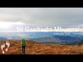
Picture: Knocknabro NE Top with The Paps to the South West.
This summit is best reached via Knocknabro West Top. Park at laneway to old farmhouse now in ruin at A (W15905 83498). Room for 1-2 cars to park. Climb gate at entrance and follow post and wire fence heading north until B (W16029 84252). From there head across open hillside in a NNW direction. It is slow going across long grass and heather cover to the summit. As you gain altitude you will meet another post and wire fence coming up from the west, i.e. on your left hand side. Follow fence to Knocknabro West summit, which is located along the fence line. No obvious marker for summit other than a nearby very small lake, which on the day of the walk was almost dry. Fantastic views across the Blackwater Valley and to the west towards The Paps. From the summit when facing north the post and wire fence heads to your right for approx. 50 metres and then turns NE in the general direction of the summit of Knocknabro North-East top. Follow fence until it ends at C (W16319 86025). From there the summit area is in view although less than 400 metres away. There is no obvious marker point other than a small raised bog area at the summit.
Add a Place Comment for Knocknabro NE Top, Cnoc na Breo (mullach thoir thuaidh) (1454) in Area: Derrynasaggart, Cen: Knocknabro, County: Kerry, Cen: Knocknabro
Member Comments for
Knocknabro NE Top (Cnoc na Breo (mullach thoir thuaidh))
Picture: One of the many waterfalls I encountered.
A watery end
by Colin Murphy
30 Mar 2022
My third Knocknabro in a day seemed, like its brothers, to be as dull as ditchwater until my descent brought some reward. I approached from the East top, which is about 1km south, and involves a slog though heather for most of the way. Featureless summit, unmarked, and barely noticeable as a separate entity. I decided to trudge my way directly west as a means of descent so that I could at least enjoy some views of Lough Glannatreaghaun beneath the Paps. This proved an effort, with unrelenting heather, marshy in places. And while I finally came in sight of the lough, the more rewarding sight was that of multiple small backlit waterfalls tumbling from the northern spur of Knocknabro West. A perfect spot for enjoying a well-earned lunch. Linkback: mountainviews.ie/summit/1454/comment/23460/
Use of MountainViews is governed by conditions and a privacy policy.
Read general information about the site. Opinions in material here are not necessarily endorsed by MountainViews.
Hillwalking is a risk sport. Information in comments, walks, shared GPS tracks or about starting places may
not be accurate for example as regards safety or access permission. You are responsible for your safety and your permission to walk.
See the credits and list definitions.


 Add a Place Comment for Knocknabro NE Top, Cnoc na Breo (mullach thoir thuaidh)


 Our Facebook page.