This website uses cookies, which are small text files that the website puts on your device to facilitate operation. Cookies help us provide a better service to you. They are used to track general user traffic information and to help the website function properly.
Feature count in area: 62, by county: Cork: 45, Kerry: 24, of which 7 are in both Cork and Kerry,
OSI/LPS Maps: 78, 79, 85, 86, 88, 89
Highest Place: Knockboy 704.8m
Starting Places (47) in area West Cork Mountains: Barley Lake North, Barrboy, Caha Pass, Carranmore, Carrigacappeen, Carriganass Castle, Castle Donovan Car Park, Clearagh House, Coolkellure House, Coomhola Bridge, Corrigatirra, Cousane Gap, Cummer Lough East Road, Derreencollig Wood, Esk Boreen, Fuhiry Wood, Garinish Island Pier, Glasagarav River Bridge, Glasnacummeen Stream, Glengarriff, Glengarriff Nature Reserve CP, Gorteeniher Drimoleague Heritage Walk CP, Gortloughra River Road, Gougane Barra Oratory, Gougane Barra Park CP, Grousemount Wind Farm, Kealkill Village, Knockanuha, Knockbrack South, Lough Atooreen N, Lough Nambrackderg North, Lough Nambrackderg Wood, Lough Nambreacdearg, Mealagh Bridge, Molly Gallivan's Visitor Centre, Nowen Hill West Road, Owvane River Bridge, Pookeen North Top Road, Pooleen Wood Car Park, Priests Leap, Reenroe Bridge, River Roughty, Shandrum Concrete Silo, Sillahertane Stream, Slaheny River Horseshoe, Top of Coom, Turner's Rock Tunnel
Summits & other features in area West Cork Mountains: Cen: Maughanaclea: Maughanaclea Hills East Top 470m, Maughanaclea Hills West Top 452m Cen: Shehy More: Shehy More 545.6m, Shehy More SW Top 446m E: Clearagh: Clearagh Hill 287m E: Currane: Currane Hill 228m N Cen: Douce: Douce Mountain 476m, Doughill Mountain 471m N: Carran: Barnastooka 497m, Bealick 537m, Carran 604m, Carran Far NE Top 561m, Carran Far North Top 506m, Carran NE Top 555m, Carran South Top 567m, Knockantooreen 450m N: Conigar: Conigar 566m, Conigar SW Top 566m, Foilastookeen 540m N: Coomataggart: Carrigalougha 423m, Coomataggart 530m, Coomataggart SW Top 509m, Derrineanig 304m, Lackabaun 472m, Mweelin 487m NE Cen: Carrigarierk: Carrigarierk 343m NW: Barraboy: Barraboy Mountain 460m, Barraboy Mountain Far East Top 456m, Barraboy Mountain SE Top 409m, Derroograne 468m, Turners Rock 420m NW: Knockboy: Caoinkeen 692.8m, Caoinkeen South-East Top 553.5m, Coomhola Mountain 472m, Knockboy 704.8m, Knockboy North Top 651.2m, Knockboy South Top 533.3m, The Priest's Leap 519m NW: Knocknamanagh: Bird Hill 412m, Coomclogherane Top 449m, Gullaba Hill 603m, Knockbrack 440m, Knockbrack South Top 458m, Knocknamanagh 637m, Knocknamanagh NE Top 625m S Cen: Dunmanway Hills: Cashloura 296.8m, Coolsnaghtig 295.8m, Inchanadreen 310m S Cen: Nowen: Milane Hill 354.4m, Mullaghmesha 494.3m, Nowen Hill 535.2m, Nowen Hill Far West Top 405.2m, Nowen Hill SW Top 509m, Pookeen North Top 319m S: Leap Hills: Carrigfadda 311.7m, Killeigh Hill 229m, Knockarudane Hill 169m, Knockscagh 195m S: Skibbereen: Barryroe Hill 156m, Lick Hill 158m W Cen: Knockbreteen: Knockbreteen 239m W: Bantry: Knocknaveagh 282m
Note: this list of places may include island features such as summits, but not
islands as such.
Foilastookeen, 540mMountain Faill an Stuaicín A name in Irish,
Place Rating ..
Ir. Faill an Stuaicín [OSi], ‘cliff of the pinnacle’ Conigar East Top an extra name in English, Cork County in Munster province, in Arderin Beg Lists, Faill an Stuaicín is the 447th highest place in Ireland.
Grid Reference W07800 64100,
OS 1:50k mapsheet 85 Place visited by: 72members, recently by: DeirdreM, learykid, Superterence, jlk, CusackMargaret, johncusack, a3642278, Grumbler, annem, Wilderness, Ulsterpooka, John.geary, Colin Murphy, dodser, childminder05
I visited this place: NO (You need to be a logged-in member for this.)
Longitude: -9.337904, Latitude: 51.822103, Easting: 107800, Northing: 64100,
Prominence: 20m, Isolation: 1.2km ITM: 507770 564164 Bedrock type: Purple & green sandstone & siltstone, (Caha Mountain Formation) Notes on name: This peak overlooks Guagán Barra / Gougane Barra from the south.
Short or GPS IDs, 6 char: Flstkn, 10 char: Flstkn Linkback: https://mountainviews.ie/summit/1448/
Gallery for Foilastookeen (Faill an Stuaicín) and surrounds
Summary
for Foilastookeen (Faill an Stuaicín):
Easy access along trail from the NE
Summary created by Colin Murphy
2022-05-31 16:52:37
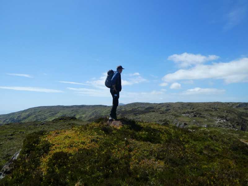
Picture: Summit high point
Probably the simplest approach (and the most scenic, is via Gougane Barra, where there is ample car parking around point Goug Br Ch (W09103 65913) (as well as a pub, hotel and toilet facilities.) Proceed up the Beara-Breifne Way track and simply follow the zig-zagging trail for 3km, which leads virtually all the way to the high point. As you ascend the views over Gougane Barra Lough and the surrounding landscape are first rate. The summit is a slightly raised mound.
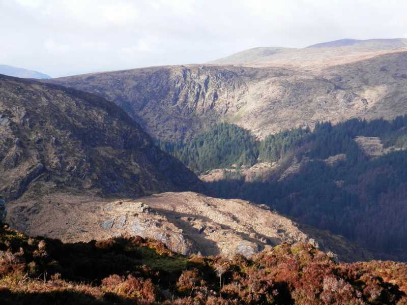
Parked at a a double gate at A (W054 647), just north of Gowlane Bridge on the road west of Conigar in the Borlin Valley (space for a single car). Hopping the gate, a farm track pointed the way uphill for a short distance. I aimed for the left of a low band of cliff on the horizon. A handy fence provided a guide over Conigar’s NE shoulder. Descending on the other side, I passed tiny Lough Glas, and continuing alongside a fence, passing the even smaller (and curiously named) Lough Namrat. At this point I realised there were trail markers for a track running alongside the fence - the Beara Breifne Way - as a small sign later indicated. And several hundred metres ahead I could see another walker crossing the summit of Foilastookeen.
It wasn't too difficult a climb to the summit - a broad area of heather and rocky outcrops. And grand views, especially north where steep cliffs drop down to Gougane Barra.
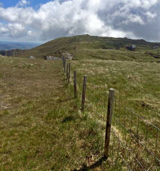
Returned by the same route, ascending back over the shoulder of Conigar and made the easy descent back to the car in about 2 hours. Linkback: mountainviews.ie/summit/1448/comment/18159/
Read Less
Read More
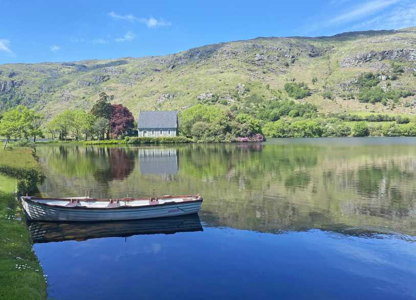
Picture: Gougane Barra Lough & Chapel
A pint to finish!
by Colin Murphy
31 May 2022
One of the advantages of starting or finishing an ascent from Gougane Barra, as it presents stunning views over the lough, especially on fine summer days, and you can also have pint if you've just descended here! Linkback: mountainviews.ie/summit/1448/comment/23528/
Use of MountainViews is governed by conditions and a privacy policy.
Read general information about the site. Opinions in material here are not necessarily endorsed by MountainViews.
Hillwalking is a risk sport. Information in comments, walks, shared GPS tracks or about starting places may
not be accurate for example as regards safety or access permission. You are responsible for your safety and your permission to walk.
See the credits and list definitions.


 Add a Place Comment for Foilastookeen, Faill an Stuaicín


 Our Facebook page.