Welcome to MountainViews
If you want to use the website often please enrol (quick and free) at top right.
If you want to use the website often please enrol (quick and free) at top right.
Overview

For more map options click on any overview map area or any detail map feature.
Detail Map Features
Showing 5 items:
Moylemore 102m, Cruit Island 32m, Torglass 25m, Inishillintry 21m,
3483, 9km
Moylemore 102m, Cruit Island 32m, Torglass 25m, Inishillintry 21m,
Tracks:
Find Suggested Walks
Find hill, mountain, island, coastal feature.
Videos
Recent Contributions
 Get Notifications
Get Notifications
Keale Mountain: Hard to access the top
Traverse of Lackavrea
 glencree
One of Irelnad`s finest routes
East Girt Hill: Short trek from West Girt Hill
 Fergalh
West Girt Hill: Short trek to summit
 Fergalh
Half Glencoaghan
Galtymore: Dawn on Galtymore
 DeirdreM
Hill of Stake: East trek along track to mines followed by wet heather bash
 Fergalh
Belmore from NW - SOUTH route CLOSED
Fynloch Hill: Outlier of Kilpatrick Hills
 Fergalh
Duncolm: Long trek followed by short sharp climb
 Fergalh
Carrane from SSW
Conditions and Info
Use of MountainViews is governed by conditions and a privacy policy.
Read general information about the site.
Opinions in material here are not necessarily endorsed by MountainViews.
Hillwalking is a risk sport. Information in comments, walks, shared GPS tracks or about starting places may not be accurate for example as regards safety or access permission. You are responsible for your safety and your permission to walk.
See the credits and list definitions.
 Visit our Facebook page.
Video display
Donegal NW
Area N: Gweedore Subarea
Place count in area: 8,
OSI/LPS Maps: 1, 10, 11
Highest place: Tievealehid, 429m
Maximum height for area: 429 metres,
Maximum prominence for area: 304 metres,
Places in area Donegal NW:
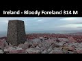
N: Gweedore:Moylemore (Owey Island) 102mCarntreena 425mBloody Foreland 314mCrocknaneeve 155.9mTievealehid 429m
S: Trawenagh:Croaghegly 245mTrusklieve 175m
W: Arranmore:Cluidaniller West Top (Aranmore) 227m
Note: this list of places includes island features such as summits, but not islands as such.
Highest place:
Tievealehid, 429mPlaces in area Donegal NW:
N: Gweedore:
Moylemore (Owey Island) 102mCarntreena 425mBloody Foreland 314mCrocknaneeve 155.9mTievealehid 429mS: Trawenagh:
Croaghegly 245mTrusklieve 175mW: Arranmore:
Cluidaniller West Top (Aranmore) 227mNote: this list of places includes island features such as summits, but not islands as such.

Reachable "On Foot " Y
Bedrock type: Coarse grained monzogranite to tonalite, (Thorr Granite)
An Mhaoil Mhór is the 1507th highest place in Ireland. An Mhaoil Mhór is the second most westerly summit in the Donegal NW area.
Linkback: https://mountainviews.ie/summit/1379/
COMMENTS for Moylemore (An Mhaoil Mhór) 1 2 Next page >>  Follow this place's comments

|
|
|
|
||
| MountainViews.ie, a Hill-walking Website for the island of Ireland. 2400 Summiteers, 1480 Contributors, maintainer of lists: Arderins, Vandeleur-Lynams, Highest Hundred, County Highpoints etc | |||