This website uses cookies, which are small text files that the website puts on your device to facilitate operation. Cookies help us provide a better service to you. They are used to track general user traffic information and to help the website function properly.
Feature count in area: 19, all in Cork,
OSI/LPS Maps: 84, 85, 88, 89
Highest Place: Mount Gabriel 407m
Starting Places (14) in area Mizen/Sheeps Head: Ahakista Pier, Brow Head Watch Tower, Cahergal, Carr Clós Dún Óir, Coosacuslaun Bay, Derrylahard East, Durrus Village, Kilcrohane, Letter Cillin CP, Mount Corrin Road, Mount Gabriel Road, Sheeps Head Turning Point, Sherkin Island Pier, Sui Finn Car Park
Summits & other features in area Mizen/Sheeps Head: NE: Mizen NE: Derrylahard East 301m, Knockaughna 268m, Mount Corrin 284m, Mount Gabriel 407m, Mount Kid 296.1m NW: Sheeps Head: Ballyroon Mountain 239m, Caher Mountain 338m, Fahane 233m, Gouladane 303m, Seefin 345m S: Cape Clear: Cnoicín an tSeabhaic (Clear Island) 160m S: Knockomagh: Knockomagh 197m S: Sherkin: Slievemore (Sherkin Island) 101m SW: Mizen SW: Brow Head 108m, Knockaphuca 237m, Knockatassonig 207m, Knocknamaddree 313m, Lackenakea 164m, Mizen Peak 232m
Note: this list of places may include island features such as summits, but not
islands as such.
Lackenakea, 164mHill
Place Rating ..
, Cork County in Munster province, in Binnion Lists, Lackenakea is the 1452th highest place in Ireland.
Grid Reference V77700 25400,
OS 1:50k mapsheet 88 Place visited by: 14members, recently by: Oscar-mckinney, Carolyn105, Taisce, chelman7, nickywood, jlk, Fergalh, markmjcampion, eamonoc, Wildrover, chalky, jackill, Conor74, garrettd
I visited this place: NO (You need to be a logged-in member for this.)
Short or GPS IDs, 6 char: Lcknk, 10 char: Lackenakea Linkback: https://mountainviews.ie/summit/1333/
Gallery for Lackenakea and surrounds
Summary
for Lackenakea :
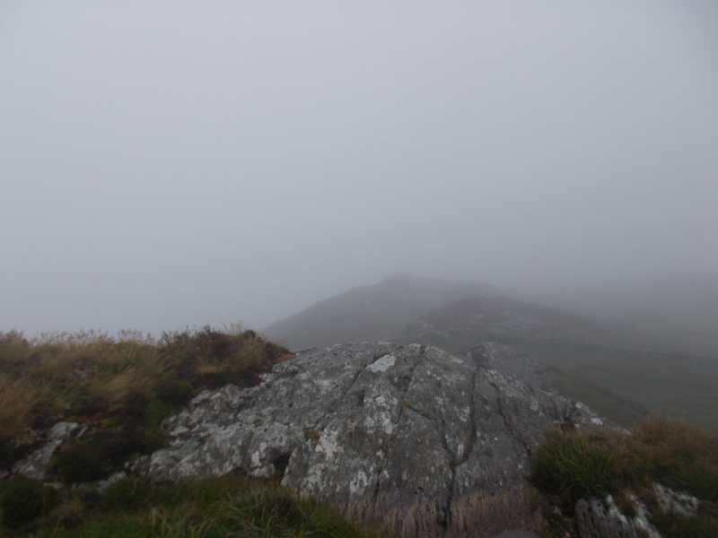
Hmmmm, is this the summit?
Summary created by Conor74
2014-06-30 09:36:22
Parked at Barley Cove, straightforward walk from the highest point of the road as it sweeps around the bay, a couple of fences to cross. Choice of 2 or 3 outcrops as summit, one has a small cairn. Great views across Crookhaven Harbour and all of the SW coast.
The OSI notes that this and nearby Arduslough (which does not appear on mv) both have a height of 164 metres, so may have to be checked to ascertain which is the actual summit and which is a "mere" spot height.
Parked at A (V770 251) and crossed fence and made my way to the top on very wet windy and misty day in July. The land slopes upwards to the obvious summit. Must be good view on another day but I saw very little. Linkback: mountainviews.ie/summit/1333/comment/20922/
Use of MountainViews is governed by conditions and a privacy policy.
Read general information about the site. Opinions in material here are not necessarily endorsed by MountainViews.
Hillwalking is a risk sport. Information in comments, walks, shared GPS tracks or about starting places may
not be accurate for example as regards safety or access permission. You are responsible for your safety and your permission to walk.
See the credits and list definitions.


 Our Facebook page.