Members and Supporters, the MountainViews Committee requests your help to meet the costs of the website and of other activities such as insured events or publications.
Feature count in area: 57, by county: Cork: 32, Kerry: 36, of which 11 are in both Cork and Kerry,
OSI/LPS Maps: 83, 84, 85, 88
Highest Place: Hungry Hill 682m
Starting Places (51) in area Caha Mountains: Ardgroom, Barley Lake North, Bere Island Pier, Caha Pass, Canshanavoe South, Carriganine, Cashelkeelty Stone Circles Carpark, Castletownbere Lifeboat Harbour, Clashduff River Farm, Coolieragh Harbour Road, Coomadayallig Lake Road N, Coomadayallig Lake Road S, Cooryeen Lane, Cummer Lough East Road, Derreenataggart Stone Circle Road, Dromoghty Lough North, Dunboy Wood, Esk Boreen, Eyeries, Fehanah Lane, Garinish Island Pier, Glantrasna Bridge, Glenbeg Lough N, Glengarriff, Glengarriff Nature Reserve CP, Gleninchaquin Waterfall, Gowlaun Lough, Healy Pass, Healy Pass Hairpin, Ilnacullin Car Park, Kenmare Bridge, Knockacullin Lane, Leahill Bog, Leitrim Beg Standing Stone, Lough Inchiquin SE, Magannagan Stream, Molly Gallivan's Visitor Centre, Nora's Cottage, Old Lansdowne School, Owgarriff River Lane, Peg's Shop, Pooleen Wood Car Park, Red Trout Lake, Reenroe Bridge, River Drimminboy Track, Rossmackowen Bridge, Rossmackowen Cemetery, Shronebirrane Farm, Shronebirrane Road, Toberbanaha, Turner's Rock Tunnel
Summits & other features in area Caha Mountains: Cen: Hungry Hill: Coombane 510m, Derryclancy 554m, Hungry Hill 682m Cen: Knockowen: Cushnaficulla 594m, Glenkeel Top 417m, Knockastumpa 398m, Knockeirky 577m, Knockeirky South Top 523m, Knockowen 658m, Stookeennalackareha 412m E: Glengarriff: Derrynafulla SW 375m, Gowlbeg Mountain 362m, Nareera 530m, Nareera North Top 503m, Nareera South-West Top 505m, Shrone Hill 283m, Sugarloaf Mountain 574m, Sugarloaf Mountain Far West Top 560m, Sugarloaf Mountain West Top 565m N: Coomnadiha: Baurearagh Mountain 489m, Caha Far SE Top 555m, Caha SE Top 585m, Coomnadiha 644m, Coomnalack Top 435m, Cummeenbaun 510m, Droppa 522m, Killane Mountain 537m, Killane Mountain South-West Top 533m, Knockagarrane 414m, Knockreagh 500m N: Knockeirka: Barraduff Mountain 400m, Killaha Mountain 400m, Knockeirka 426m N: Knocknagorraveela: Derrysallagh 410m, Feorus East 474m, Knocknagorraveela 507m, Knocknagorraveela NE Top 464m N: Lauragh: Knockanoughanish 386m, Knockatee 330m S: Castletownbere: Disert 205m, Knockanallig (Bear Island) 267m W: Ardgroom: Derryvour Hill 160m W: Eskatarriff: Coomacloghane 599m, Eskatarriff 600.5m, Eskatarriff East Top 532.7m, Knocknaveacal North Top 509.1m, Knocknaveacal South Top 507.2m, Lackabane 603m, Tooreenbaha 408.7m, Tooreennamna 524m, Tooth Mountain 592m W: Knocknagree: Knocknagree 586m, Knocknagree East Top 461m, Knocknagree SE Top 442m, Lackawee 572m, Maulin 621m, Maulin North Top 579m
Note: this list of places may include island features such as summits, but not
islands as such.
Hungry Hill, 682mMountain Cnoc Daod A name in Irish,
Place Rating ..
(Ir. Cnoc Daod [OSI] or Daod [T6000], 'hill of the tooth/set of teeth')), Cork County in Munster province, in Arderin, Vandeleur-Lynam, Irish Highest Hundred Lists, Hungry Hill is the highest mountain in the Caha Mountains area and the 140th highest in Ireland. Hungry Hill is the third highest point in county Cork.
Grid Reference V76088 49726,
OS 1:50k mapsheet 84 Place visited by: 388members, recently by: rhw, Sarahjb, JohnFinn, Deirdreb, DeirdreM, maoris, Carolineswalsh, knightsonhikes, MarionP, Ansarlodge, Padraigin, westside, ToughSoles, Jimmy600leavey, SFlaherty
I visited this place: NO (You need to be a logged-in member for this.)
Longitude: -9.792407, Latitude: 51.68698, Easting: 76088, Northing: 49726,
Prominence: 400m, Isolation: 1.8km, Has trig pillar
ITM: 476071 549807 Bedrock type: Purple & green sandstone & siltstone, (Caha Mountain Formation) Notes on name: Hungry Hill is the title of a novel by Daphne du Maurier based on the story of the family of her friend, Christopher Puxley, whose family acquired Dunboy Castle and its lands after the defeat of Donal Cam O'Sullivan Beare. The copper mines located on the hill in the novel are in reality further west near Allihies. The second element of the Irish name, Cnoc Daod, has long been regarded as obscure, but it is probably simply a dialectal variant of déad meaning ‘tooth’, ‘jaw’ or ‘set of teeth’. A family living at the foot of the hill are known locally as the Bun Daods.
Short or GPS IDs, 6 char: HngrHl, 10 char: Hungry Hil Linkback: https://mountainviews.ie/summit/130/
Gallery for Hungry Hill (Cnoc Daod) and surrounds
Summary
for Hungry Hill (Cnoc Daod):
Commanding rocky Beara highpoint on N-S ridge with eastern cliffs and lakes
Summary created by markmjcampion
2023-09-14 17:42:38
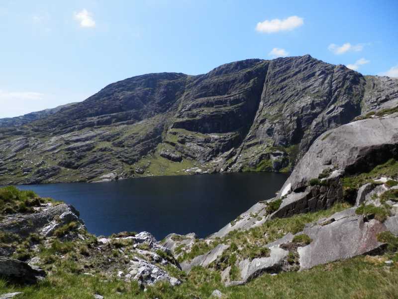
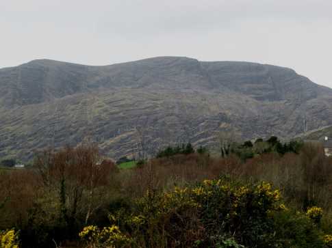
Picture: Hungry Hill from Coomadavallig Lake
Hungry Hill in the Caha Mts is the highest peak in the Beara peninsula with commanding views of much of W Cork and S Kerry as well as Cape Clear and the Skelligs. It's topped by a boggy plateau with a lot of rocky and v dangerous ground above its eastern corries and fine ridges to the south and west. Be very careful in descending as there is very steep ground to the E and S, sea mist can roll in suddenly and it can get very windy at times.
S. From the S, park on the hard shoulder near Ross Br (V74545 47355). There is also parking near the end of the obvious minor road but it's very narrow with few passing places. From end of minor road at Nora Ctg (V75012 48123) head into open country and options include :.
Tackle the steep but walkable SW ridge if the weather allows. There is nice scrambling here too. 2 hrs
Or take the Beara Way west to A (V74642 49344) then, following the stream, aim for approx. B (V75071 50364) before taking a marked track to the summit plateau. 2 hrs
Or take the BW east for about 1 km branching off to intersect the SE ridge close to C (V73643 49783). Then pick your way up the layered, benched ridge either scrambling or dodging the abundant rock. Allow 2.5 hrs+
NE. From the NE it's possible to summit on relatively safe ground from the Healy Pass passing over two other peaks as you do. 2 hrs+ to the top
E. From the E start at CmdaligLRN (V78663 49595) and follow track/3355 which entails a fine route around the two famed E coums. 2.5hrs+
Other tracks of note are track/3184 and track/1344.
HUNGRY HILL - SOUTH WEST RIDGE SCRAMBLE. Grade 1.
This is a very fine easy scrambling route. The well-defined ridge line rises direct to the summit in a series of low rock steps Most are easy; any harder options can be taken or avoided at will.
Take the r.hand turn off the R572 at Rossmackowen Bridge (grid ref: Ross Br (V745 475) OSI map 84) where a few parking spaces that will not displease the (very friendly) farmer can be found further up the road. Follow the track round to Loch Park a short distance round from which the bottom of the ridge is very obvious. Barry Keane in his Collins Press Beara guide instructs to start from the obvious notch in the ridge further on, but this is to miss the initial section, which seems a shame. The summit views are very fine, especially down into the entrancingly beautiful Gleann Mhoir to the north. A quick descent can be made via the grass rake on the south face below the ridge (see photo).
If attempting a circuit of Comnagapple be very sure to stick to the broad West ridge as much as possible. The incredibly rough 'benches' of ribbed rock that define the Caha easily become a
dispiriting maze and destroy any notion of distance measured 'as the crow flies'. As it is, the ridge path is rough and not all that obvious. Descents are possible with care straight down from the west ridge. If making the circuit, aim to stay above the Glas Lochs to pick up the boreen leading down (D (V733 499)) from which turns off the path leading back across to Comnagapple and Loch Park and the start. Linkback: mountainviews.ie/summit/130/comment/2680/
Read Less
Read More
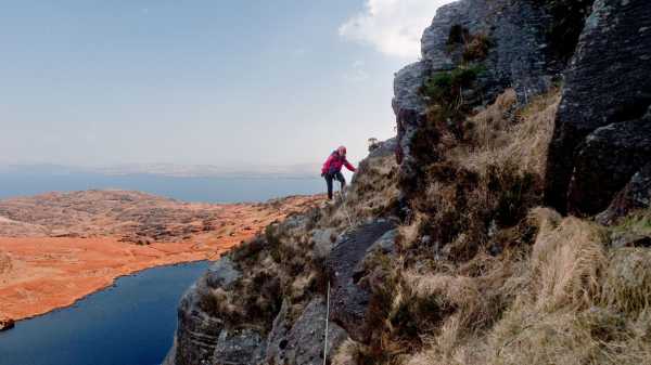
Picture: High on the east face
Not an easy route
by mcrtchly
7 May 2010
To the casual observer the east face of Hungry Hill South presents an impenetrable barrier. But on closer inspection a steep gully can be seen which splits the face close to apex of the corrie just at the northern end of Coomarkane Lake. This gully was our chosen way to breach the face as we decided to follow the description given by Lynch in his book on “Munster’s Mountains”. We began the climb to the left of the gully where we donned our climbing gear (harness, helmet, rope and rock shoes) and attacked a section of hard scrambling on mixed rock and grass before dropping right into the gully proper. A short grassy climb leads to the next obstacle which was a small slab of rock. This was by-passed by scrambling to the left of the slab followed by a move back across above the top of the slab. Then the crux of the climb loomed ahead of us – a narrow chimney which at first sight appeared to be an easy climb. But upon reaching the foot of the chimney the climb became more serious than we thought. The chimney is long and steep. It is best tackled by taking holds on the right face which are perhaps V.Diff. in grade.
Above the chimney the seriousness of the route lessens for a while until a small crag blocked the gully and the route took a detour up a rocky ramp to the left, followed by a scramble over the top of the crag. Here things went a bit astray. We should have regained the gully above the crag but the route was unclear and I guess we crossed the gully to right and descended on a layback into a parallel gully. At first this parallel gully was easy going but then got steeper as we went upwards. Eventually we found a ridge on the right and dropped into a rock shelter above a steep wall. We thought that we were now close to the top of the route and swapped our rock shoes for our hiking boots – a bad decision. By now we were feeling bit lost. The direct route from the rock shelter to the right looked particularly tricky, so we went left. Here the route got progressively steeper until we met a wet and vegetated rock buttress. It looked like few people had been here before. I tentatively attacked the rock face and found that my hiking boots gave little grip on the slimy rock. Only a leap of faith on a dubious foot hold saw me surmount the obstacle and reach a safe belay where I could bring up my partner. After this the route eased to an exposed traverse leftwards across the face and a scramble to reach the south summit of Hungry Hill.
This was not the best of scrambles. Either we went wrong somewhere or the description was lacking. Fortunately we found a safe route to the summit (and had the gear and experience to do so). Had it not been so then things might have been more serious. As described by kernowclimber, the route down from Hungry Hill was also a challenge. Whilst we are thankful to Lynch in presenting new routes up the mountains we must also warn about the potential dangers for those without the means to tackle them. Linkback: mountainviews.ie/summit/130/comment/4688/
Read Less
Read More
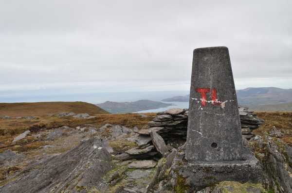
Picture: Trig Point
There and back
by trekker
21 Apr 2012
I recently walked Hungry Hill from the Healy Pass and I must say I cannot fathom why this route isn't more popular. I parked at the top of the pass and headed southwest to the first summit of the day,Coombane. From there the route was obvious,again southwest, to Derryclancy. From the summit of Derryclancy you can see the bulk of Hungry Hill ahead.You will notice at least two bands of grass ascending the right hand side. Take either of these until they disappear,at which point you turn left and climb easily enough the remaining 150 metres to the summit. To return to your car simply retrace your steps Linkback: mountainviews.ie/summit/130/comment/6765/
Read Less
Read More
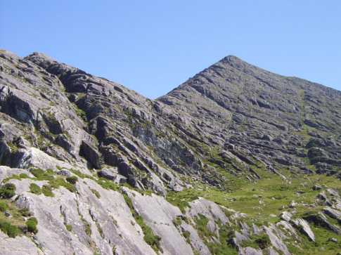
Picture: Hungry Hill from the SE
pdtempan on Hungry Hill
by pdtempan
22 Mar 2009
This photo shows the bulky profile of Hungry Hill, seen from the townland of Reen, just west of Adrigole. The swirling bands of rock which are the trademark of the Caha Mountains are very much in evidence here. Writing about the hills around Glengarriff, Kevin Corcoran gives the following explanation about the geology of the Cahas: "Looking up to the higher hills you may recognise the characteristic terraced pleats of the layers of sandstone. These clearly illustrate the warping effect that occurred as these mountains were forced upwards over 250 million years ago by the Armorican or Hercynian movements (West Cork Walks, p. 99)." Linkback: mountainviews.ie/summit/130/comment/3668/
Read Less
Read More
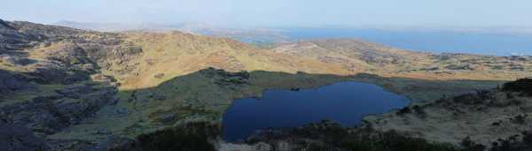
Picture: Coomarkane Lake
Hungry Hill via Coomarkane’s East Gully
by kernowclimber
6 May 2010
At Adrigole we turned onto the R572 and then took the second right down a small road for about 2km. At CmdaligLRS (V78030 49242) there is ample parking space near the stile that marks the beginning of the walk. The early afternoon was warm, still and silent, broken intermittently by the feeble cries of newborn lambs and the sudden popping of gorse buds. Following the stream flowing down from Coomarkane Lake we scrambled steeply upwards past gushing waterfalls, rewarded by gorgeous views down the valley towards Adrigole Harbour and the nearby hill of Coomgira with its bare bands of rock that resembled an armadillo’s back. The flame coloured gorse had set the hedgerows ablaze and its delicate perfume was borne upwards on the gentlest of breezes.
The reed fringed Coomarkane Lake soon came into view, an oasis of tranquillity with insects gliding languidly over its mirror-like surface. Close to where a small river flows into the northern part of the lake are some giant rocks, one of which gives shelter to the ruinous walls of a sheep fold or booley. Nearby lie twin slabs of sandstone spilt in a cataclysmic tumble from on high, providing an ideal stage for viewing the lake and the gully we were about to climb, the deep crevice between them harbouring a variety of verdure safe from nibbling sheep.
This 600m climb is rated V. Diff and is described separately. Benches of rock sporting straw-dry grass tangled amid wiry heather combined with wet and vegetated chimneys to make climbing awkward in places; I would have preferred the challenge of naked rock. Upward progress was slow and route finding difficult, but the sight of ancient estuarine ripples in the Devonian red sandstone and the views over Coomarkane Lake and Bantry Bay were truly uplifting.
I was relieved to finally find myself climbing the grassy slopes leading to the summit trig pillar of Hungry Hill in the fading rays of the sun. We stayed long enough to see the vermillion orb of the sun slip below the horizon, turning the clouds into a Baroque work of art in shades of pinks, purples and greys. Then, following the instructions in Denis Lynch’s Munster’s Mountains, we headed south past the impressive cairn at spot height 667 to descend “on steep rocky ground to the 300m contour line approximately [to] contour round the east spur as far as the Coomarkane Stream”.
Trying to navigate downwards over huge shelves of rock with sheer drops by the light of head torches was difficult and dangerous so we decided to descend to the safer 200m contour line and bore roughly E towards Gortnarea. We re-ascended to about the 300m contour line to traverse the tail end of Lynch’s ‘spur’ and gain the valley we came up. We tarried awhile, lying on a sun-warmed pavement of sandstone to gaze upon the night sky misty with stars, arriving back at our car much later than anticipated. We would caution only the very experienced hill walker to attempt Lynch’s descent route in adverse weather or failing light. Linkback: mountainviews.ie/summit/130/comment/4684/
Use of MountainViews is governed by conditions and a privacy policy.
Read general information about the site. Opinions in material here are not necessarily endorsed by MountainViews.
Hillwalking is a risk sport. Information in comments, walks, shared GPS tracks or about starting places may
not be accurate for example as regards safety or access permission. You are responsible for your safety and your permission to walk.
See the credits and list definitions.


 Our Facebook page.