This website uses cookies, which are small text files that the website puts on your device to facilitate operation. Cookies help us provide a better service to you. They are used to track general user traffic information and to help the website function properly.
Feature count in area: 15, all in Mayo,
OSI/LPS Maps: 23, 24, 31, 32
Highest Place: Nephin 806m
Starting Places (13) in area East Mayo: Bellanaderg Bridge, Cloondaff Church, Cuilkillew S, Glasheens River, Gortnadrehy South, Gortnadrehy West, L5709 Lugnamannaun River, Lough Ben, Loughanaveeny, Nephin CP Fiddaunduff, Nephin CP Forest Road, R312 Boghadoon, R312 Prughlish
Summits & other features in area East Mayo: E: Charlestown Hills: Knock Hill 213m, Mullaghanoe 234m N: Foxford Hills: Carranarah 197m, Gortnadrehy 143m NW: Nephin: Cuilkillew 130m, Nephin 806m, Tristia 322m NW: Pontoon Hills: Crucknaree 297m, Farbreiga 395m, Knockaglana 154m S: Kiltimagh Hills: Rush Hill 197m, Slieve Carn 262m W: Croaghmoyle: Burren 396m, Croaghmoyle 430m, Muckanagh Hill 220m
Note: this list of places may include island features such as summits, but not
islands as such.
Knock Hill, 213mHill
Place Rating ..
, Mayo County in Connacht province, in Binnion Lists, Knock Hill is the 1377th highest place in Ireland. Knock Hill is the second most easterly summit in the East Mayo area.
Grid Reference M47100 96450,
OS 1:50k mapsheet 32 Place visited by: 25members, recently by: dregish, annem, finkey86, magnumpig, glenlecky, Reeks2011, liz50, wicklore, Wildrover, juliewoods, Jamessheerin, moggy40, moggy40t, conormcbandon, Garmin
I visited this place: NO (You need to be a logged-in member for this.)
Short or GPS IDs, 6 char: Knc213, 10 char: Knock H213 Linkback: https://mountainviews.ie/summit/1275/
Gallery for Knock Hill and surrounds
Summary
for Knock Hill :
Fly by summit
Summary created by liz50
2017-10-08 15:11:05
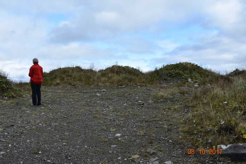
Picture: Which pile of rubble is the true summit!
You can choose to park in a layby at A (M47093 96666) and walk a total distance of 400m by crossing the main road to Knock Airport and following a narrow tarmac road uphill, turning right at the top to the summit which is beside a telecommunications mast or you can drive up. There is a view over Knock Airport from the top with the mountains of North Mayo in the background.
Take the turn off for the airport than park one km along at a layby (A (M47093 96666)). You than walk up road opposite to top and turn right at the top walk 200 metres to Telecommunications mast the high point lies a few metres west in a small outcrop (although it is arguable if the soil dumped at the east side is higher). In fact this is the only hill you can fly to and walk to if you should be so inclined as it is only one km from the airport ! Linkback: mountainviews.ie/summit/1275/comment/15859/
Read Less
Read More
Picture: Knock Hill and airport.
Not Pretty!!
by paddyhillsbagger
14 Apr 2014
A rather disappointing hill scarred with quarry works, masts, perimeter fence and an airport! 10 minutes up and down. There is a conifer tree by the rocky outcrop of the top in the picture taken from the earthworks which appear higher. Linkback: mountainviews.ie/summit/1275/comment/16003/
Use of MountainViews is governed by conditions and a privacy policy.
Read general information about the site. Opinions in material here are not necessarily endorsed by MountainViews.
Hillwalking is a risk sport. Information in comments, walks, shared GPS tracks or about starting places may
not be accurate for example as regards safety or access permission. You are responsible for your safety and your permission to walk.
See the credits and list definitions.


 Our Facebook page.