Cookies.
This website uses cookies, which are small text files that the website puts on your device to facilitate operation. Cookies help us provide a better service to you. They are used to track general user traffic information and to help the website function properly.
Features
Nearby features appear when you click the map.
Declutter tracks on map.
Place Search
Video
X
Pub: by
Wicklow Area , W: Cen Lugnaquilla Subarea
Feature count in area: 115, by county: Wicklow: 108, Kildare: 4, Wexford: 2, Carlow: 3, of which 1 is in both Wexford and Wicklow, of which 1 is in both Carlow and Wicklow, OSI/LPS Maps: 28B, 55, 56, 61, 62, AWW, EW-DM, EW-LG, EW-WE, EW-WS
Highest Place: Lugnaquilla 924.7m

Starting Places (205) in area Wicklow:
1916 Memorial Car Park, Aghavannagh Ow Bridge, Aghowle Wood, Altidore Wood Entrance, Annacurra National School, Annalecka Bridge, Asbawn Brook L8350, Aughrim National School, Ballard Road, Ballinabarny Gap, Ballinagappoge Bridge Layby, Ballinagappoge Mountain Hairpin, Ballinagore, Ballinahinch Wood, Ballinastoe MBT CP, Ballinastraw South, Ballineddan Upr Fork, Ballinfoyle Upr Cross, Ballycoog, Ballycreen Brook Bridge, Ballycumber, Ballycumber Bridge, Ballycumber Lane, Ballycumber Wicklow Way, Ballylerane, Ballylow Bridge, Ballylusk Quarry, Ballymanus Lane, Ballymoyle Shooting Lodge, Ballynultagh Gap, Ballynultagh Lane, Ballyreagh Wood, Ballyross Forest, Ballysmuttan Long Stone, Baravore, Barnbawn South, Barranisky North, Barranisky West, Bohilla Land Roundabout, Bohilla Lane Mid, Boranaraltry Bridge, Bray Harbour, Brewel West, Brittas Bay North CP, Buckroney Sand Dunes CP, Bus Terminus, Camera Hill Track Cross, Castletimon Wood North, Clara Vale, Clone House Road, Clonegal, Cloon Wood Cp, Coate Bridge, Coolballintaggart Ledge, Coolbawn House Lane, Cransillagh Brook , Crone Wood CP, Crossbridge, Crossoona Rath, Cummer Wood South, Curtlestown Wood CP, Deputy's Pass CP, Derralossary Church, Derry River Bridge, Devil's Glen CP, Devil's Glen Wood, Djouce Wood Calary, Djouce Wood Lake, Djouce Wood Long Hill, Donard, Donnelly's Lane Car Sales, Drumgoff Forest, Dunranhill North, Dunranhill SE, Dunranhill South, Dwyer McAllister Cottage CP, Enniskerry, Fentons Pub, Fitzsimons Park GAA, unuseableFlemings Footbridge Glen Rd, Gap Pub, Gap Road, Glen Beach CP, Glen of the Downs CP, Glenbride Lane, Glenbride Lodge, Glencree Reconciliation, Glendalough, Glenealy GAA, Glenmacnass Tonelagee CP, Glenmalure Hostel, Glenmalure Lodge, Glenmalure Waterfall, Glenview Hotel, Gowle House, Great Sugar Loaf CP, Grove Bar, Heffernans Well Wood, Hill View, Hollywood Glen, JB Malone CP, Johnnie Fox Pub, Keadeen NE trail, Keadeen Trailhead, Kevins Way Footbridge, Kilbride Army Camp Entrance, Kilcandra South, Kilcommon View, Killalongford Wood, Kilmacrea Cross Roads, Kilranelagh House Gate, Kilruddery Car Park, Kilruddery Cottages, Kings River, Kippure Bridge, Kippure Estate, Kippure Transmitter Gate, Knickeen Cross, Knocknaboley Lane Leeraghs Bog, Knocknaboley Lane Stone Cottage, Knockrath Little, Knockree west, Kyle Loop North, Lackan Wood S, Lake Dr Fraughan Brook, Lake Drive, Lake Park Cross, Lake View Pub, Laragh Free Car Park, Laragh NSch, Lead Mines CP, Liffey Bridge, Liffey Head Bridge, Lough Bray Lower, Lough Bray Upper, Lough Tay North Viewing Point, Lough Tay Wicklow Way CP, Luglass Lane L97561, Lugnagun Track, Macreddin Village, Mangans Lane, Military Road Carrigshouk Hill, Military Road Inchavore River Nth, Military Road Inchavore River Sth, Military Road NW Lough Tay, Military Road Ballyboy Bridge, Military Road Cloghoge Brook, Military Road Croaghanmoira, Military Road Fananierin, Military Road LaraghWicklow Way, Military Road Slieve Maan, Monspolien Bridge, Moortown House, Mountain Rescue HQ, Muskeagh Little Wood, Nahanagan Lough NE, Novara Avenue, Bray, Oiltiagh Brook Knickeen, Old Bridge Cross, Old Bridge Scouts , Old Wicklow Way entrance, Paddock Hill SE, Pier Gates CP, Powerscourt Waterfall CP, Putland Road, Quintagh East, Raheen Park CP, Raheenleagh East, Railway Walk CP, Rathdrum Railway Station, Rednagh Wood, Rocky Valley, Roundwood, Sally Gap, Sally Gap N, Seefin Trailhead, Seskin SE, Shankill Tributary Bridge, Shay Elliott, Sheepshanks Bridge, Shillelagh, Slievecorragh Track, Slievefoore South, Sraghoe Brook, St John's Church, St Kevins Chair, St Kevins Church, St Kevins Way R756, Stone Circle Bridge, Stookeen South, Stranahely Wood, Stranakelly Cross Roads, Tallyho, Templeboden, Tithewer, Tomcoyle Lower, Tomriland Wood, Toor Brook, Trooperstown Hill Access, Turlough Hill CP, Upper Lake CP, Vallymount GAA CP, Vartry Reservoir Upper, Zellers Pub

Summits & other features in area Wicklow:
Cen: Glendalough North: Brockagh Mountain 556.9m, Brockagh Mountain NW Top 549.5m, Brockagh Mountain SE Top 471.7m, Camaderry East Top 677.3m, Camaderry Mountain 698.6m, Conavalla 734m, Tomaneena 682.4m
Cen: Glendalough South: Carriglineen Mountain 456.6m, Cullentragh Mountain 510m, Derrybawn Mountain 476.1m, Kirikee Mountain 474.5m, Lugduff 653.2m, Lugduff SE Top 638m, Mullacor 660.7m, Trooperstown Hill 430m
N Cen: Tonelagee: Carrignagunneen 561m, Fair Mountain 571.2m, Stoney Top 713.7m, Tonelagee 815.8m, Tonelagee E Top 668m, Tonelagee South-East Top 545.8m
NE: Bray & Kilmacanogue: Bray Head Hill 238.9m, Carrigoona Commons East 242m, Downs Hill 372.9m, Great Sugar Loaf 501.2m, Little Sugar Loaf 342.4m
NE: Djouce: Djouce 725.5m, Knockree 342.1m, Maulin 570m, Tonduff 642m, Tonduff East Top 593m, War Hill 684.8m, White Hill 631.1m
NE: Fancy: Ballinafunshoge 480m, Kanturk 527.4m, Knocknacloghoge 532.4m, Luggala 593.3m, Robber's Pass Hill 508.9m, Scarr 640m, Scarr North-West Top 559.8m, Sleamaine 430m
NE: Vartry: Ballinacorbeg 336m, Ballycurry 301m, Dunranhill 342m, Mount Kennedy 365.9m
NW: Blessington: Carrigleitrim 408m, Lugnagun 446.2m, Slieveroe 332m, Sorrel Hill 599.5m
NW: Mullaghcleevaun: Black Hill 602.2m, Carrigshouk 572.5m, Carrigvore 682.4m, Duff Hill 720.8m, Gravale 719m, Moanbane 703m, Mullaghcleevaun 846.7m, Mullaghcleevaun East Top 796m, Silsean 698m
S: Aughrim Hills: Cushbawn 400m, Killeagh 249m, Moneyteige North 427m, Preban Hill 389m
S: Croaghanmoira: Ballinacor Mountain 529.3m, Ballycurragh Hill 536m, Ballyteige 447m, Carrickashane Mountain 508m, Croaghanmoira 662.3m, Croaghanmoira North Top 579.5m, Fananierin 426m, Slieve Maan 547.8m, Slieve Maan North Top 546.1m
S: Croghan Kinsella: Annagh Hill 454m, Croghan Kinsella 606m, Croghan Kinsella East Top 562.1m, Slievefoore 414m
S: Shillelagh Hills: Lakeen 357m, Monaughrim 206m, Seskin 344m, Stookeen 420m
S: Tinahely Hills: Ballycumber Hill 429.7m, Eagle Hill 296m, Muskeagh Hill 398.2m
SE: Wicklow South East: Ballinastraw 284m, Ballyguile Hill 188m, Barranisky 280m, Carrick Mountain 381m, Collon Hill 238m, Kilnamanagh Hill 217m, Westaston Hill 270m
W: Baltinglass: Ballyhook Hill 288m, Baltinglass Hill 382m, Carrig Mountain 571m, Carrigeen Hill 298m, Cloghnagaune 385m, Corballis Hill 258m, Keadeen Mountain 653m, Spinans Hill 409m, Spinans Hill SE Top 400m, Tinoran Hill 312m
W: Cen Lugnaquilla: Ballineddan Mountain 652.3m, Benleagh 689m, Camenabologue 758m, Camenabologue SE Top 663m, Cloghernagh 800m, Corrigasleggaun 794.6m, Lugnaquilla 924.7m, Slievemaan 759.7m
W: Donard: Brewel Hill 222m, Church Mountain 544m, Corriebracks 531m, Lobawn 636m, Slievecorragh 418m, Sugarloaf 552m, Table Mountain 701.7m, Table Mountain West Top 563m

Note: this list of places may include island features such as summits, but not islands as such.
Rating graphic.
Benleagh, 689m Mountain Binn Liath A name in Irish,
Place Rating ..
(prob. Ir. Binn Liath [PDT], 'grey peak'), Strands of Baravore, Wicklow County in Leinster province, in Arderin Beg, Vandeleur-Lynam Lists, Benleagh is the 131st highest place in Ireland.
Grid Reference T03866 94180, OS 1:50k mapsheet 56
Place visited by: 396 members, recently by: jackos, lauracardiff, frostie89, Hjonna, Courin, rhw, maoris, davidrenshaw, MarionP, Prem, Carolineswalsh, Kaszmirek78, michaelseaver, NualaB, ToughSoles
I visited this place: NO (You need to be a logged-in member for this.)
Longitude: -6.454146, Latitude: 52.988643, Easting: 303866, Northing: 194180, Prominence: 24m,  Isolation: 1.2km
ITM: 703789 694219
Bedrock type: Aphyric granodiorite, (Percys Table Granodiorite)

  Short or GPS IDs, 6 char: Bnlgh, 10 char: Benleagh

Linkback: https://mountainviews.ie/summit/126/
Gallery for Benleagh (Binn Liath) and surrounds
Summary for Benleagh (Binn Liath): Tough climb, so-so top, amazing views
Summary created by Colin Murphy 2013-04-16 16:48:03
            MountainViews.ie picture about Benleagh (<em>Binn Liath</em>)
Picture: Fraughan Rock Glen from Benleagh
Starting at the large carpark at B'vore (T06617 94163) in Glenmalure, cross the nearby footbridge. Once across the ford, follow the good Coillte track as far as A (T057 948), where the track splits. Take a left into Fraughan Rock Glen and continue as a far as B (T054 939), level with the edge of the tree plantation. Head directly up along the line of these trees. It is steep terrain and the going underfoot can be treacherous, as there are multiple boulders, hidden bog holes, rotting tree stumps etc, but it is passable with care. You will eventually emerge at C (T053 944). The remainder is a simple, relatively gentle climb to the SW of about 500m, which will take you to the top, which is unremarkable, but marked by a small cairn. However, the views on this last section of the walk overlooking Fraughan Rock Glen are as good as any you will see in Ireland.
Linkback: mountainviews.ie/summit/126/comment/4886/
Member Comments for Benleagh (Binn Liath)
Comment create / edit display placeholder

            MountainViews.ie picture about Benleagh (<em>Binn Liath</em>)
What have these cliffs not seen!
by padodes 20 Apr 2010
A blue sky over Benleagh and not a contrail in sight, thanks to the vagaries of Icelandic ash! And that wasn’t the only thing I had to wonder at, as I walked along the arching cliff-top the other day.

For one thing, a group of climbers was slowly working its way up one of the crumbling buttresses of the cliff face (the one you can see in the photo). Do those chaps know something about the law of gravity that the rest of us known nothing of? The granite on the cliff face, shattered by the passage of ice into giant, cantilevered blocks, has all the appearance of a tilted, top-heavy stack of dominos that only needs a careless nudge to come tumbling down. I’m sure a mathematician could produce a very sobering calculation of the various probabilities.

Looking around, I almost found it more reassuring to turn my thoughts to the bloody battle that raged in the two valleys around Benleagh, on the 25 August 1580. When Lord Grey made his ill-fated attempt to crush the Gaelic power of Feagh McHugh O’Byrne by leading his army into Glenmalure, it is surmised that he left his baggage train in the Glen of Imaal and approached either from the west, over Table Mountain and Camenabologue, or from the southwest, between Cannow Mountain and Benleagh, dropping down into the Fraughan Rock Glen. One of the English chroniclers who lived to fight another day describes the terrain as follows: “When we entered the foresaid Glen, we were forced to slide some tymes three or four fadoms er we colde staie our feete; it was in depth where we entered … full of stones, rocks, bogs and wood, in the bottom thereof a ryver full of lose stones, wch we were dryven to crosse dyverse tymes.” Even in its present state of deforestation, one can still imagine what the invading troops had to contend with in these valleys before ever the wily Feagh fell upon them. Anyone sitting that August day on Benleagh would have had a grandstand view of some of the proceedings. Linkback: mountainviews.ie/summit/126/comment/4648/
Read Less
Read More

            MountainViews.ie picture about Benleagh (<em>Binn Liath</em>)
padodes on Benleagh
by padodes 5 Oct 2007
Benleagh can also be approached from the south, and even without having to do any rock climbing it is one of the more challenging ways of getting to the top. The photo, which I took three weeks ago while descending from Art's Lough, helps to visualise the route. Following the forest track from Baravore into Fraughan Rock Glen, when you draw level with the last stand of now fast disappearing pines on the right hand side before the cliffs begin to tower above (the pines visible mid way up the slope on the right of photo), leave the track (roughly, B (T054 939)) and head straight for the left hand side of the pines (D (T052 940)) and from there climb straight up the steepening slope. When I climbed it myself earlier this year, I emerged through a little gully onto the ridge at E (T051 943). Looking at the picture, this route may appear quite straightforward, but it gives little idea of the difficulties of the terrain. The slope quickly becomes a jumble of rocks and boulders, often with a thick covering of heather, fern, furze and fraughans. It sometimes requires a hands-on effort to keep balance and avoid hidden holes between the rocks, but scrambling would be too fine a word for it. Once on the ridge, it is easy to follow it westwards to its hightest point before turning slightly NW to the nondescript summit of Benleagh itself. In fine weather, the walk along the ridge offers wonderful views of the hanging valleys at the head of the glen or of Art's Lough to the south, like a blue eye winking across from under the dark brow of Cloghernagh. It's easy to wax lyrical in places like this. Linkback: mountainviews.ie/summit/126/comment/2845/
Read Less
Read More

            MountainViews.ie picture about Benleagh (<em>Binn Liath</em>)
Picture: It was so nice i had to paint it.
A nice ascent
by Rob_Lee 2 Jun 2014
There's nothing too interesting about Benleagh top, it's fairly flat and boggy, though it is exciting to hear the rumble of explosions coming over the hill from Glen of Imaal artillery range.
To make up for the unimpressive summit Benleagh has a lovely ascent from Fraughan Rock Glen. Before you start the steep climb up the side of the valley you walk along a quiet and peaceful track with lovely views looking up from between the high cliffs to the foot of Lugnaquilla. Linkback: mountainviews.ie/summit/126/comment/15037/
Read Less
Read More

            MountainViews.ie picture about Benleagh (<em>Binn Liath</em>)
GWPR on Benleagh
by GWPR 3 Dec 2003
Winter now and the shorter day mean an earlier start to get 5/6 hours in the mountains.

I start at Baravore Youth Hostel at the top of Glenmalure and follow the track around to the left
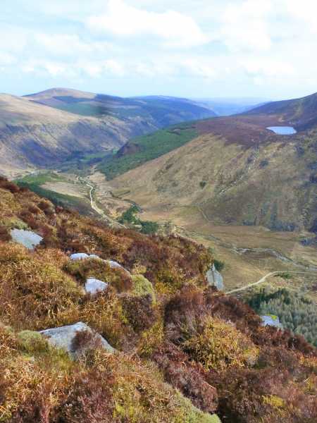
to reveal the great opening of the Fraughan Rock Glen. On my right hand side are the imposing cliffs of Benleagh. and on the left the brooding shoulder of Cloghernagh ,in shadow in the early morning light. Climbing up by the left side of the waterfall, winter rains have formed cascades over great polished slabs of granite. To the sounds of gurgling waters I arrive at the top of the hanging valley leading to the opening of the Fraughan Rock Glen. I head for a gully directly ahead and start a short scramble to arrive on a bony ridge which connects to that great East-West Spur between Lug and Cloghernagh.
Lug is ahead now and above the South Prison the ground is white with frost.
Arriving at the great cairn I take a breather and some photos of course! Hikers are arriving from all
directions to meet at this great gathering point. Others are heading for Table Mt and the Three Lakes
but I head east now for Cloghernagh and plan to descend by Art’s Lough.
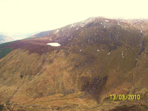
On my left Kelly’s Lough is dark and mysterious under Corrigasleggaun.
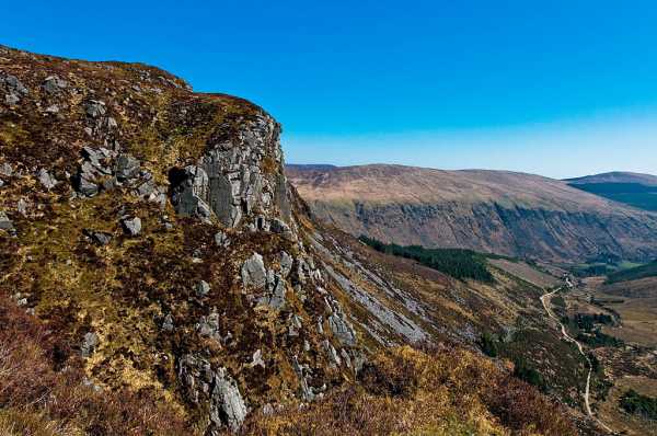
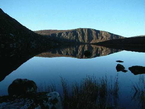
Arriving at the cairn on Cloghernagh I take great care to get the next part right as the descent to Art’s Lough is a bit tricky. Joss Lynam in his excellent book ‘ Walk Guide – East of Ireland’ recommends – ‘To avoid cliffs on the direct route (from the cairn on Cloghernagh) walk about north/northeast for approx. 500m., then swing north and finally northwest to descend on a grassy ramp to the lake.’ Having followed these directions faithfully what a sight I beheld. Here in the late winter sunlight , Art’sLough like a liquid mirror held a perfect relection of the Cliffs of Benleagh! Could I capture on camera this magnificent mountain view? I took as many photos as the late evening light allowed with the thought that I still needed light for the tough descent from Art’s Lough to the track back to Baravore. Reluctantly I descend with an everlasting image in my mind, if not on film! Linkback: mountainviews.ie/summit/126/comment/763/
Read Less
Read More

            MountainViews.ie picture about Benleagh (<em>Binn Liath</em>)
Picture: Arts Lough taken from east of Benleagh
darrenf on Benleagh
by darrenf 15 Mar 2010
With the short spell of good weather we appear to be having it would be a shame not to get out over the weekend. So I headed off down to Glenmalur on Saturday 13th March. Yup I had it all planned out...just me, Lug, the snow capped peaks and if I was lucky maybe even some deer. Sure who else would be out what the rugby on.....as I struggled to find a suitable spot to lay up the car in Baravore carpark B'vore (T066 942) I cursed my niavity. Well I was here now and would have to make the most of the day. Im not the biggest fan of heavy populated areas and would tend to steer clear of the general direction the hoards seem to be moving toward. So after a quick review of the map it was decided, Benleagh & Camenabologue would be on the menu.

Crossed the Avonbeg River via the footbridge and contuined along the gravel track which leads up to the an oige youth hostel and shortly afterwards took the track which bears left (contuining on the original track will take you further into the Glenmalur valley). Followed this forest track right around into Fraughan Glen where the views really open out in front of you. The entire track is not clearly identified on Sheet 56 (at least my dated one!!) but it will take you deep into the glen and only really peters out at the back wall of the glen - at this point another faint track can be picked up which stays to the right hand side of the benleagh river and continues up and over Fraughan Glen. Spectacular views back down the glen and across to Lugduff can be enjoyed. Once over the glen I was glad I decided to give Lug a miss given the amount of people coming to and fro. Sticking next to the benleagh river will provide a good handrail and before long the river noticebly forks right and I forked with it! The going along this strecth of the walk was boggy and gaiters are advisable! The river eventually peters out but navigation is simple enough. It did however take me some time to locate the exact summit of Benleagh but after much circling around I stumbled upon the cairn which is perched aloft a peat hag.

I couldn't resist a short detour before I contuined on to Camenabologue and I headed east of Benleagh to really get a good look over the cliffs surrounding Fraughan Glen. The picture below was taken from one of the rocky outcrops over the glen on the Benleagh side, and clearly shows Arts Lough. From here I retraced my steps back to Benleagh and continued on to Camenabologue. Refer to same for rest of route. Linkback: mountainviews.ie/summit/126/comment/4506/
Read Less
Read More
EDIT Point of Interest
text
Videos


Recent Contributions
x
Conditions and Info
Use of MountainViews is governed by conditions and a privacy policy.
Read general information about the site.
Opinions in material here are not necessarily endorsed by MountainViews.
Hillwalking is a risk sport. Information in comments, walks, shared GPS tracks or about starting places may not be accurate for example as regards safety or access permission. You are responsible for your safety and your permission to walk.
See the credits and list definitions.

OSi logo
OSNI/LPS logo
Open Street Map
(Various variations used.)
British summit data courtesy:
Database of British & Irish Hills