Cookies.
This website uses cookies, which are small text files that the website puts on your device to facilitate operation. Cookies help us provide a better service to you. They are used to track general user traffic information and to help the website function properly.
Features
Nearby features appear when you click the map.
Declutter tracks on map.
Place Search
Video
X
Pub: by
Wicklow Area , S: Tinahely Hills Subarea
Feature count in area: 115, by county: Wicklow: 108, Kildare: 4, Wexford: 2, Carlow: 3, of which 1 is in both Wexford and Wicklow, of which 1 is in both Carlow and Wicklow, OSI/LPS Maps: 28B, 55, 56, 61, 62, AWW, EW-DM, EW-LG, EW-WE, EW-WS
Highest Place: Lugnaquilla 924.7m

Starting Places (205) in area Wicklow:
1916 Memorial Car Park, Aghavannagh Ow Bridge, Aghowle Wood, Altidore Wood Entrance, Annacurra National School, Annalecka Bridge, Asbawn Brook L8350, Aughrim National School, Ballard Road, Ballinabarny Gap, Ballinagappoge Bridge Layby, Ballinagappoge Mountain Hairpin, Ballinagore, Ballinahinch Wood, Ballinastoe MBT CP, Ballinastraw South, Ballineddan Upr Fork, Ballinfoyle Upr Cross, Ballycoog, Ballycreen Brook Bridge, Ballycumber, Ballycumber Bridge, Ballycumber Lane, Ballycumber Wicklow Way, Ballylerane, Ballylow Bridge, Ballylusk Quarry, Ballymanus Lane, Ballymoyle Shooting Lodge, Ballynultagh Gap, Ballynultagh Lane, Ballyreagh Wood, Ballyross Forest, Ballysmuttan Long Stone, Baravore, Barnbawn South, Barranisky North, Barranisky West, Bohilla Land Roundabout, Bohilla Lane Mid, Boranaraltry Bridge, Bray Harbour, Brewel West, Brittas Bay North CP, Buckroney Sand Dunes CP, Bus Terminus, Camera Hill Track Cross, Castletimon Wood North, Clara Vale, Clone House Road, Clonegal, Cloon Wood Cp, Coate Bridge, Coolballintaggart Ledge, Coolbawn House Lane, Cransillagh Brook , Crone Wood CP, Crossbridge, Crossoona Rath, Cummer Wood South, Curtlestown Wood CP, Deputy's Pass CP, Derralossary Church, Derry River Bridge, Devil's Glen CP, Devil's Glen Wood, Djouce Wood Calary, Djouce Wood Lake, Djouce Wood Long Hill, Donard, Donnelly's Lane Car Sales, Drumgoff Forest, Dunranhill North, Dunranhill SE, Dunranhill South, Dwyer McAllister Cottage CP, Enniskerry, Fentons Pub, Fitzsimons Park GAA, unuseableFlemings Footbridge Glen Rd, Gap Pub, Gap Road, Glen Beach CP, Glen of the Downs CP, Glenbride Lane, Glenbride Lodge, Glencree Reconciliation, Glendalough, Glenealy GAA, Glenmacnass Tonelagee CP, Glenmalure Hostel, Glenmalure Lodge, Glenmalure Waterfall, Glenview Hotel, Gowle House, Great Sugar Loaf CP, Grove Bar, Heffernans Well Wood, Hill View, Hollywood Glen, JB Malone CP, Johnnie Fox Pub, Keadeen NE trail, Keadeen Trailhead, Kevins Way Footbridge, Kilbride Army Camp Entrance, Kilcandra South, Kilcommon View, Killalongford Wood, Kilmacrea Cross Roads, Kilranelagh House Gate, Kilruddery Car Park, Kilruddery Cottages, Kings River, Kippure Bridge, Kippure Estate, Kippure Transmitter Gate, Knickeen Cross, Knocknaboley Lane Leeraghs Bog, Knocknaboley Lane Stone Cottage, Knockrath Little, Knockree west, Kyle Loop North, Lackan Wood S, Lake Dr Fraughan Brook, Lake Drive, Lake Park Cross, Lake View Pub, Laragh Free Car Park, Laragh NSch, Lead Mines CP, Liffey Bridge, Liffey Head Bridge, Lough Bray Lower, Lough Bray Upper, Lough Tay North Viewing Point, Lough Tay Wicklow Way CP, Luglass Lane L97561, Lugnagun Track, Macreddin Village, Mangans Lane, Military Road Carrigshouk Hill, Military Road Inchavore River Nth, Military Road Inchavore River Sth, Military Road NW Lough Tay, Military Road Ballyboy Bridge, Military Road Cloghoge Brook, Military Road Croaghanmoira, Military Road Fananierin, Military Road LaraghWicklow Way, Military Road Slieve Maan, Monspolien Bridge, Moortown House, Mountain Rescue HQ, Muskeagh Little Wood, Nahanagan Lough NE, Novara Avenue, Bray, Oiltiagh Brook Knickeen, Old Bridge Cross, Old Bridge Scouts , Old Wicklow Way entrance, Paddock Hill SE, Pier Gates CP, Powerscourt Waterfall CP, Putland Road, Quintagh East, Raheen Park CP, Raheenleagh East, Railway Walk CP, Rathdrum Railway Station, Rednagh Wood, Rocky Valley, Roundwood, Sally Gap, Sally Gap N, Seefin Trailhead, Seskin SE, Shankill Tributary Bridge, Shay Elliott, Sheepshanks Bridge, Shillelagh, Slievecorragh Track, Slievefoore South, Sraghoe Brook, St John's Church, St Kevins Chair, St Kevins Church, St Kevins Way R756, Stone Circle Bridge, Stookeen South, Stranahely Wood, Stranakelly Cross Roads, Tallyho, Templeboden, Tithewer, Tomcoyle L, Tomriland Wood, Toor Brook, Trooperstown Hill Access, Turlough Hill CP, Upper Lake CP, Vallymount GAA CP, Vartry Reservoir Upper, Zellers Pub

Summits & other features in area Wicklow:
Cen: Glendalough North: Brockagh Mountain 556.9m, Brockagh Mountain NW Top 549.5m, Brockagh Mountain SE Top 471.7m, Camaderry East Top 677.3m, Camaderry Mountain 698.6m, Conavalla 734m, Tomaneena 682.4m
Cen: Glendalough South: Carriglineen Mountain 456.6m, Cullentragh Mountain 510m, Derrybawn Mountain 476.1m, Kirikee Mountain 474.5m, Lugduff 653.2m, Lugduff SE Top 638m, Mullacor 660.7m, Trooperstown Hill 430m
N Cen: Tonelagee: Carrignagunneen 561m, Fair Mountain 571.2m, Stoney Top 713.7m, Tonelagee 815.8m, Tonelagee E Top 668m, Tonelagee South-East Top 545.8m
NE: Bray & Kilmacanogue: Bray Head Hill 238.9m, Carrigoona Commons East 242m, Downs Hill 372.9m, Great Sugar Loaf 501.2m, Little Sugar Loaf 342.4m
NE: Djouce: Djouce 725.5m, Knockree 342.1m, Maulin 570m, Tonduff 642m, Tonduff East Top 593m, War Hill 684.8m, White Hill 631.1m
NE: Fancy: Ballinafunshoge 480m, Kanturk 527.4m, Knocknacloghoge 532.4m, Luggala 593.3m, Robber's Pass Hill 508.9m, Scarr 640m, Scarr North-West Top 559.8m, Sleamaine 430m
NE: Vartry: Ballinacorbeg 336m, Ballycurry 301m, Dunranhill 342m, Mount Kennedy 365.9m
NW: Blessington: Carrigleitrim 408m, Lugnagun 446.2m, Slieveroe 332m, Sorrel Hill 599.5m
NW: Mullaghcleevaun: Black Hill 602.2m, Carrigshouk 572.5m, Carrigvore 682.4m, Duff Hill 720.8m, Gravale 719m, Moanbane 703m, Mullaghcleevaun 846.7m, Mullaghcleevaun East Top 796m, Silsean 698m
S: Aughrim Hills: Cushbawn 400m, Killeagh 249m, Moneyteige North 427m, Preban Hill 389m
S: Croaghanmoira: Ballinacor Mountain 529.3m, Ballycurragh Hill 536m, Ballyteige 447m, Carrickashane Mountain 508m, Croaghanmoira 662.3m, Croaghanmoira North Top 579.5m, Fananierin 426m, Slieve Maan 547.8m, Slieve Maan North Top 546.1m
S: Croghan Kinsella: Annagh Hill 454m, Croghan Kinsella 606m, Croghan Kinsella East Top 562.1m, Slievefoore 414m
S: Shillelagh Hills: Lakeen 357m, Monaughrim 206m, Seskin 344m, Stookeen 420m
S: Tinahely Hills: Ballycumber Hill 429.7m, Eagle Hill 296m, Muskeagh Hill 398.2m
SE: Wicklow South East: Ballinastraw 284m, Ballyguile Hill 188m, Barranisky 280m, Carrick Mountain 381m, Collon Hill 238m, Kilnamanagh Hill 217m, Westaston Hill 270m
W: Baltinglass: Ballyhook Hill 288m, Baltinglass Hill 382m, Carrig Mountain 571m, Carrigeen Hill 298m, Cloghnagaune 385m, Corballis Hill 258m, Keadeen Mountain 653m, Spinans Hill 409m, Spinans Hill SE Top 400m, Tinoran Hill 312m
W: Cen Lugnaquilla: Ballineddan Mountain 652.3m, Benleagh 689m, Camenabologue 758m, Camenabologue SE Top 663m, Cloghernagh 800m, Corrigasleggaun 794.6m, Lugnaquilla 924.7m, Slievemaan 759.7m
W: Donard: Brewel Hill 222m, Church Mountain 544m, Corriebracks 531m, Lobawn 636m, Slievecorragh 418m, Sugarloaf 552m, Table Mountain 701.7m, Table Mountain West Top 563m

Note: this list of places may include island features such as summits, but not islands as such.
Rating graphic.
Eagle Hill, 296m Hill
Place Rating ..
, Carlow County in Leinster province, in Binnion Lists, Eagle Hill is the 1172th highest place in Ireland.
Grid Reference S97150 79020, OS 1:50k mapsheet 62
Place visited by: 17 members, recently by: SenanFoley, loftyobrien, eugeneryan959, conormcbandon, madfrankie, Garmin, markmjcampion, frankmc04, kernowclimber, mcrtchly, Geansai, chalky, jlk, sandman, eamonoc
I visited this place: NO (You need to be a logged-in member for this.)
Longitude: -6.558604, Latitude: 52.853687, Easting: 297150, Northing: 179020, Prominence: 110m,  Isolation: 6.4km, Has trig pillar
ITM: 697077 679058
Bedrock type: Pale, fine to coarse-grained granite, (Tullow Type 2 Equigranular Granite)

  Short or GPS IDs, 6 char: EglHl, 10 char: Eagle Hill

Linkback: https://mountainviews.ie/summit/1151/
Gallery for Eagle Hill and surrounds
No summary yet for this place .
Member Comments for Eagle Hill
Comment create / edit display placeholder

Access denied
by mickhanney 31 Aug 2023
I was passing Hacketstown this morning so I thought I'd give Eagle hill a visit. I've driven past it many a time.
However, my attempt would come to nothing. I followed previous walkers notes, and parked near GAA and walked up to the gate at the Woodside bark factory. But, there was a new-ish looking sign on the gate (to the hill) declaring private property, no access. That was a bit discouraging particularly being so near to the summit and one could see a well-trodden trail over the gate leading to the summit.
I drove back to Hacketstown and tried the previous road (first left turn off Hacketstown main st. from Tinahely), as that looked like another promising option.
However, having walked up a cul-de-sac leading to a quiet farm - no one around to ask - I had to give up. Again gates into the fields from this road had private property, no access signs.
I did ask about access at the local garage but they couldn't shed light on the signs, so looks like hill is off limits from previous used route. Linkback: mountainviews.ie/summit/1151/comment/24025/
Read Less
Read More

            MountainViews.ie picture about Eagle Hill
Picture: Eagle Hill with prominent cross
A Hill Fit For a King…
by kernowclimber 20 Apr 2015
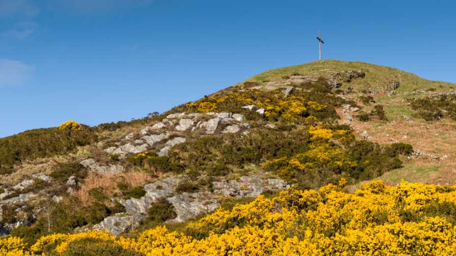
As one of my local 100s, and in the final potpourri of summits put off along with the likes of Carrigleitrim and Barranisky (need I say more?!!) I had not expected much of Eagle Hill. How wrong I was! This little hill punches far above its weight and offers the climber ample reward. Just before the Hackestown GAA club, we took the road on the left signed ‘Woodside Bark’ which ends at a timber yard. There is ample parking on the right just before a high metal gate at weekends, but during weekdays when the business is operating, it might be wise to park in a lay-by further down the road. From the parking point the hill, with its prominent cross, looms ahead. According to mcrtchly, Eagle Hill is a highly tectonised granite outcrop that lies on a shear zone and is composed of predominately metamorphosed quartz which has resisted weathering leaving it raised above the surrounding landscape. It is perhaps best viewed from the north west, where a short section of steep cliffs lends it a dramatic profile.

Crossing the high metal gate, we easily navigated our way though swathes of golden gorse and began the steep climb toward the very visible cross over a broken down barbed wire fence. In summer bracken might be an issue, but in mid-spring the ground was peppered with the delicate flowers of white cranesbill, wood sorrel and violets. In addition to the cross commemorating Youth Year 1995 and which seems to be illuminated at night, the summit also sports a trig point and undoubtedly offers the finest vista of the southern side of the Wicklow mountain range, with fabulous views of Lugnaquilla and its South Prison. But that is not all. In fine weather Mount Leinster and the Blackstairs to the south are clearly visible, beyond which it’s possible to make out the smoky grey peak of Slievenamon in the Comeraghs. On the horizon to the west lie the Slieve Bloom range and south east is a delightful vista that includes Croghan Kinsella. For such a little hill, its summit views are fabulous.

One final point of interest, is that had it not been for a dispute over land in 1775 in Hacketstown, Elvis Aaron Presley might have sung with a Carlow accent and Graceland might be nestling at the foot of Eagle Hill! Records apparently show that his four times great-grandfather, William Presley, was forced to flee his home close to Hacketstown and took ship for America where he eventually settled in Tennessee in 1781. Imagine The King’s hits inspired by his ancestral home-place: Wild in the Bogland; Old Sheep; Green Suede Shoes; Wicklow Rain; Sheep Dog; A Carlow Trilogy, Hacketstown Rock; Blue Moon of Wicklow… Linkback: mountainviews.ie/summit/1151/comment/17938/
Read Less
Read More

            MountainViews.ie picture about Eagle Hill
Picture: View to Keadeen and Baltinglass Hill
Eyrie views
by eamonoc 7 Feb 2014
Following in the footsteps of Fergalh, I took Carlow road out of Hacketstown , and then an immediate left onto L20005 towards Clonmore, on the left just before Hackestown GAA club there is the road mentioned by Fergalh, sign here for Woodside Bark. Drove up this about 100mts parked in the layby. Walked up road climbed gate , very muddy path here for about 50mts followed it gave way to drier conditions higher up. Short sharp climb up to large cross and trig point. Cross commemorates Youth year 1995 and erected by Bishop P Lennon, stone from thhe garden of Gethsemane used in the construction of Cross?. Fantastic views in all directions from summit. Took 18mins car to car and a distance of 1.1km. Linkback: mountainviews.ie/summit/1151/comment/15835/
Read Less
Read More

Not a big climb but wonderful views.
by Fergalh 1 Mar 2014
Take Carlow road out of Hacketstown then first right. Proceed up hill until you get to road on right at (A (S96504 79099)). Park at layby halfway up on left, than walk to gate, climb over and proceed up well worn track to top. Fantastic views from the top of west Wicklow mountains and hills...

Always ask landowner permission to cross land, never ever damage fences and beware of livestock. Linkback: mountainviews.ie/summit/1151/comment/15831/
Read Less
Read More
EDIT Point of Interest
text
Videos


Users Online
Daingean, jimmel567, RangerBrian, Krumel, garrettd, GerryCarroll, learykid, Dee68
Guests online: 258
Recent Contributions
x
Conditions and Info
Use of MountainViews is governed by conditions and a privacy policy.
Read general information about the site.
Opinions in material here are not necessarily endorsed by MountainViews.
Hillwalking is a risk sport. Information in comments, walks, shared GPS tracks or about starting places may not be accurate for example as regards safety or access permission. You are responsible for your safety and your permission to walk.
See the credits and list definitions.

OSi logo
OSNI/LPS logo
Open Street Map
(Various variations used.)
British summit data courtesy:
Database of British & Irish Hills