This website uses cookies, which are small text files that the website puts on your device to facilitate operation. Cookies help us provide a better service to you. They are used to track general user traffic information and to help the website function properly.
Feature count in area: 25, all in Kerry,
OSI/LPS Maps: 70, 71, 78, EW-DC, EW-DE, EW-DW
Highest Place: Beenoskee 826m
Starting Places (34) in area Central Dingle: Anascaul Village, Annascaul Lake, Ballyduff Grave Yard, Brandon Village, Cloghane Community Centre, Conor Pass, Doonore South, Doorah, Dromavally Mountain SE, Emlagh Cross, Emlagh Wood, Farrannakilla School, Glan Mountain, Glanteenassig Lane, Glanteenassig Wood CP, Glennahoo River, Hostel Cloghane Village, Killiney R560 Junction, Kilmore Lodge, Lios Pole Church, Lisduff Rath, Lough Camclaun, Lough Caum, Lough Doon CP, Lougher, Maum Cross, Maumnahaltora Cross, Minard Beach, Mullaghveal Farm, Owenascaul Estuary, Pedlars Lodge, Pilgrimage Trail Owenmore River, Sauce Creek Walkway Dingle Way, Teerbrin
Summits & other features in area Central Dingle: Cen: Annascaul Lake West: Cnoc na Bánóige 641.6m, Cnoc na Bánóige North Top 447.6m, Knockmulanane 593.2m, Knockmulanane West Top 563.5m Cen: Dromavally: Cummeen 477m, Dromavally Mountain 552m, Knocknakilton 423m N: Annascaul Lake North: Coombane 610m, Beenatoor 592m, Beenoskee 826m, Stradbally Mountain 798m N: Carrigdav: Carrigadav 240m N: Fermoyle: Farrandalouge 144m S: Annascaul: Beenmore 252m, Brickany 374m, Knockafeehane 301m, Knocknanacree 286m W: Ballyduff: Slievenalecka 458.4m, Beenbo 476.7m, Slievenagower 485.8m W: Slieveanea: An Cnapán Mór 649m, Knockmoylemore 493m, Croaghskearda 608m, Slievanea 628.7m, Slievanea NE Top 670.7m
Note: this list of places may include island features such as summits, but not
islands as such.
Knockafeehane, 301mHill Binn an Phréacháin A name in Irish,
Place Rating ..
, Brackavane, Féith Bhán, Kerry County in Munster province, in Binnion Lists, Knockafeehane is the 1161th highest place in Ireland.
Grid Reference Q61600 01400,
OS 1:50k mapsheet 71 Place visited by: 28members, recently by: annem, Pizzagirl, chelman7, Moses, mh400nt, Marykerry, scapania, jlk, markmjcampion, JohnAshton, conormcbandon, mountainmike, liz50, paddyhillsbagger, jgdarcy
I visited this place: NO (You need to be a logged-in member for this.)
Longitude: -10.022609, Latitude: 52.147584, Easting: 61600, Northing: 101400,
Prominence: 130m, Isolation: 1.8km ITM: 461580 601455 Bedrock type: Aeolian sandstone, (Kilmurry Sandstone Formation) Notes on name: Ir. Binn an Phréacháin [logainm.ie], 'peak of the crow'
Short or GPS IDs, 6 char: Knckfh, 10 char: Knckfhn Linkback: https://mountainviews.ie/summit/1142/
Gallery for Knockafeehane (Binn an Phréacháin) and surrounds
Summary
for Knockafeehane (Binn an Phréacháin):
Rewarding views.
Summary created by simon3, paddyhillsbagger
2019-10-29 19:57:14
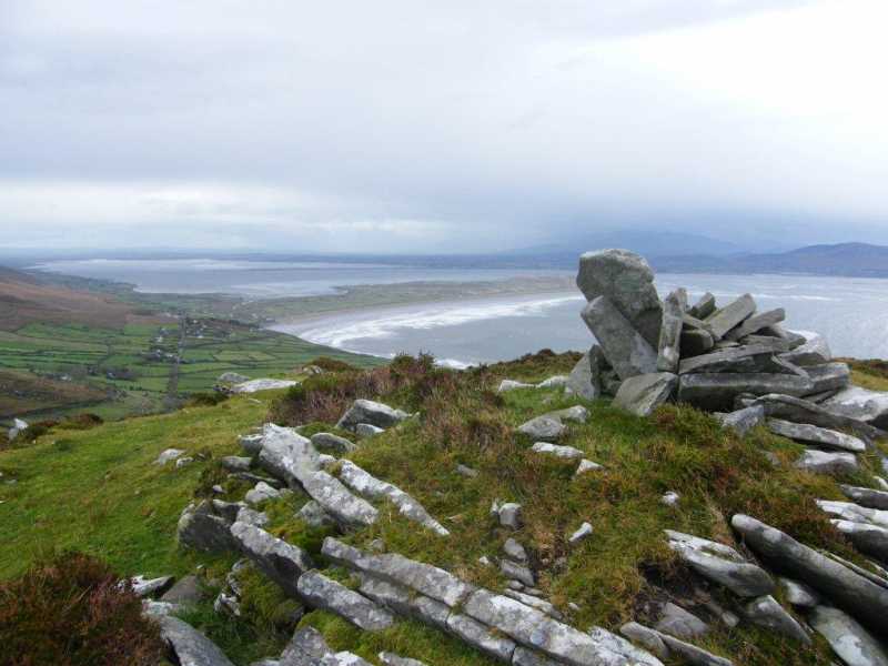
There is parking near the stile at A (Q61478 02068) for 3 cars. Circular walk map board here also. Easy walk roughly North to top with rewarding views of Inch Strand and beyond.
Park at Maum X (Q61908 01873) (1 car just).
Walk to the junction enter little lane just before house.
It's a quick up and down over rough ground. Nice views though. This is farmland but no one was about to ask permission. Linkback: mountainviews.ie/summit/1142/comment/19557/
Read Less
Read More
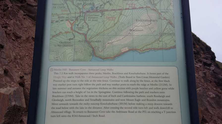
Picture: Trail over this hill as shown on map-board in Annascaul
Easily Accessible and not overly demanding
by Bunsen7
17 Aug 2018
There is a waymarked trail to the summit which loops over the ridge leading west from this hill. See track 3881.
The quickest route to the top would see you park in Annascaul village and walk up the Maum butter road eastwards (incidentally this is also part of the Dingle Way), before crossing a stile southwards at A (Q61478 02068).
Having reached the top, you can follow the trail westwards along the ridgetop, whereupon two further rises occur Brackloon (270m) and Meelin Hill (212m). Follow the walker posts down to the road at B (Q59652 00497).
Head north along the R561. The second right turn leads you onto a quiet laneway which deposits you at the Tom Crean "park" across from the South Pole Inn. Linkback: mountainviews.ie/summit/1142/comment/20022/
Read Less
Read More
Picture: West to East Trail Description
From the horse's mouth
by Bunsen7
22 Aug 2018
This is the trail description post at B (Q59652 00497). It summarises the route if taken from west to east, as per track 3881.
Vastly superior to my own garbled efforts!
Annascaul obviously is a very welcoming place for hillwalkers with a strong local group. A very tidy town as well and many other places could learn a thing or two from what has been achieved here.
Use of MountainViews is governed by conditions and a privacy policy.
Read general information about the site. Opinions in material here are not necessarily endorsed by MountainViews.
Hillwalking is a risk sport. Information in comments, walks, shared GPS tracks or about starting places may
not be accurate for example as regards safety or access permission. You are responsible for your safety and your permission to walk.
See the credits and list definitions.


 Add a Place Comment for Knockafeehane, Binn an Phréacháin


 Our Facebook page.