This website uses cookies, which are small text files that the website puts on your device to facilitate operation. Cookies help us provide a better service to you. They are used to track general user traffic information and to help the website function properly.
Feature count in area: 58, all in Down,
OSI/LPS Maps: 20, 29, EW-CLY
Highest Place: Slieve Donard 849m
Starting Places (33) in area Mourne Mountains: Alex Steddom Tree, Aughrim Airstrip, Ben Crom Dam, Bloody Bridge Car Park, Carlingford Greenway, Carrick Little, Crocknafeola Wood, Crotlieve Mountain, Donard Car Park Newcastle, Drummanmore Picnic, Fofanny Reservoir, Forest Office CP, Gamekeepers Lodge CP, Happy Valley Trassey Rd, Hen Mountain CP, Leitrim Lodge CP, Mayo Road Corner, Meelmore Lodge, Newcastle Harbour, Ott CP, Red Bog Road, Rourkes Park, Sandy Brae, Silent Valley Reservoir Head Rd, Slieve Donard Trail Head, Slieve Foye Viewing Point, Slievefoy Forest CP, Spelga Dam E, Spelga Dam N, Spelga Dam S, Trassey Car Park, Two Mile River CP, Yellow Water Park
Summits & other features in area Mourne Mountains: Cen: Loughshannagh: Ben Crom 526m, Carn Mountain 585.2m, Carn Mountain North Top 553.7m, Doan 592.6m, Ott Mountain 526.8m, Slieve Loughshannagh 617m, Slieve Muck 670.4m, Slievenaglogh 445m E: Binnian: Slieve Binnian 745.9m, Slieve Binnian East Top 639m, Slieve Binnian North Top 678m, Slieve Binnian North Tor 682.5m, Wee Binnian 460m E: Donard: Chimney Rock Mountain 656m, Crossone 540m, Millstone Mountain 460m, Rocky Mountain 524m, Slieve Donard 849m E: Lamagan: Cove Mountain 654.8m, Slieve Beg 595.9m, Slievelamagan 702.2m N: Bearnagh: Slieve Bearnagh 739m, Slieve Bearnagh North Tor 680m, Slieve Meelbeg 701.9m, Slieve Meelmore 687m N: Castlewellan: Slievenalargy 280m, Slievenaslat 272m N: Commedagh: Slieve Commedagh 767m, Slieve Corragh 641.9m, Slievenaglogh 584.4m, Slievenaglogh East Top 571m N: Croob: Cratlieve 429m, Slieve Croob 534m, Slievegarran 391m, Slievenisky 446m N: Rathfriland: Knockiveagh 235m S: Kilkeel: Knockchree 306m S: Rostrevor: Crenville 460m, Finlieve 578m, Slievemartin 485m, Slievemeel 420m, Slievemeen 472m W: Hilltown: Gruggandoo 382m, Slieveacarnane 296m W: Slievemoughanmore: Crotlieve Mountain 347m, Eagle Mountain 638m, Rocky Mountain 404m, Shanlieve 626m, Slievemoughanmore 560m, Tievedockaragh 473m, Wee Slievemoughan 428m W: Spelga: Butter Mountain 500m, Cock Mountain 504m, Cock Mountain South-West Top 505m, Hen Mountain 354m, Pigeon Rock Mountain 534m, Pigeon Rock Mountain South Top 530m, Slievenamiskan 444m
Note: this list of places may include island features such as summits, but not
islands as such.
Slievelamagan, 702.2mMountain Sliabh Lámhagáin A name in Irish,
Place Rating ..
(Ir. Sliabh Lámhagáin [PNNI], 'creeping/crawling mountain'), Down County in Ulster province, in Arderin, Vandeleur-Lynam, Irish Highest Hundred Lists, Slievelamagan is the 110th highest place in Ireland.
Grid Reference J32887 26032,
OS 1:50k mapsheet 29 Place visited by: 625members, recently by: SenanFoley, Muscles1960, Marykerry, eimirmaguire, aaronm002, Nailer1967, Henning86, rhw, MeabhTiernan, orlaithfitz, davidrenshaw, Magic, Prem, Carolineswalsh, MarionP
I visited this place: NO (You need to be a logged-in member for this.)
Longitude: -5.966147, Latitude: 54.166118, Easting: 332887, Northing: 326033,
Prominence: 149m, Isolation: 1.3km ITM: 732807 826038 Bedrock type: Granite granophyre, (Mourne Mountains granite) Notes on name: So named, according to Harris (author of The Antient and Present State of the County of Down), because it has to be climbed in a crawling position. The southern slopes are, indeed, relentlessly steep. An alternative name, Sliabh Snámháin, has the same meaning. Below Lamagan Slabs is a spot called Percy Bysshe, which suggests a connection with the poet Shelley.
Short or GPS IDs, 6 char: Slvlmg, 10 char: Slvlmgn Linkback: https://mountainviews.ie/summit/106/
Gallery for Slievelamagan (Sliabh Lámhagáin) and surrounds
Summary
for Slievelamagan (Sliabh Lámhagáin):
Steep, rocky peak with great local views
Summary created by markmjcampion, Peter Walker, jackill
2023-09-11 13:13:54
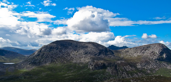
Picture: Slievelamagan as seen from Rocky, Cove to the right
Slieve Lamagan in the E Mournes is a rough, rocky prominence whose SW spur can cause much huffing and puffing. The peak takes the form of a S-N ridge with a lesser gap on the N side, and with very steep, craggy E flanks. Lamagan is a fine viewpoint for the other high Mournes, esp Binnian and Bearnagh, but the higher ground nearby takes substantial slices out of the more distant prospects.
S. Park at Carrick Little CP Carrick (J34499 21928), room for 10-15 cars - this fills quickly on weekends but there is plentiful parking for a small fee per day up the lane or in other locations nearby - please avoid parking on the roadside. Walk up the farm track next to the carpark and through a gate to open hillside. Follow a rough track up to A (J32112 25602), turn NE and pick your way up Lamagan's rocky face with occasional traces of a path. 2hrs+
From the same start SL can also be incorporated into a circuit of the Annalong valley, including the Binnians if time allows.
SW. Start at B (J30591 21029) and walk to Ben Crom dam, then follow a recently constructed path to A (J32112 25602) before climbing up the rough hillside as mentioned previously. 3 hrs
N. The summit can also be reached via the summits of S. Beg and Cove Mt – take the path up the Glen River from Newcastle then drop down to the Brandy Pad before heading for S. Beg. Park at DonCPNc (J37443 30632). 3 hrs
SL is also one of the mts on the Mournes Sevens challenge.
Notable tracks – circular track/3423, linear track/4477 and track/2286.
The “Seven Sevens”. The intricacies of which I know nothing, the movers and shakers of which I know nothing and the finer objectives of which I know nothing. Essentially the thing is to ascend all the Mournes over seven hundred metres, in one day - such a day allotted, being evidenced by members of something, standing in yellow jackets at points and ….. pointing.
I expect some people sprint the course - backwards, between somersaults. I myself chose to walk it, in flagrant disregard of the event proper: in secret. It is manageable for regular track rats, but gruelling. Kick off at Carrick Little and zoom up the beautiful Annalong track to the Castles. Legover the Saddle and up/down Donard to Commedagh: blitz the ridge to Hare’s Gap. Wheel round Bearnagh and up Meelmore thereoff to Meelbeg and reverse to the saddle between, down to the bog and up Bearnagh.You may wish to be sick at this point: be it, because in another hour you may be anything (a dandelion or a warthog) and not know it. To the Brandy Pad and up Slieve Beg. Then Cove: breakfast on a hair trigger: but sure there are only two left: ONLY Lamagan, ONLY Binnian! Atop Lamagan and your legs have become candy floss and you’re singing something from South Pacific. Then Binnian like a mirage, edges back as you edge forward. The next hour could be years or seconds then you’re in the car in the passenger seat, hunting for the steering wheel. Take this route, because when you come off, you’re only minutes on a tarred road from the car. All others close in endless trails where you could could easily succumb and wake up looking at a crow with your one good eye. Utterly pointless and maybe obligatory. Linkback: mountainviews.ie/summit/106/comment/1302/
Read Less
Read More
The Mourne Seven Sevens
by hbowman
8 Aug 2010
I climbed this mountain yesterday as part of the Mourne 7'7s. Started in Donard car park around 7am and followed the traditional route to the summit of Slieve Donard - up to the saddle and left. Upon reaching the summit, it was a case of following the wall back down to the saddle and up Slieve Commedagh. From one summit to the other took me 35 minutes. Hikers are faced with a choice at this stage - either head along the wall towards Bernagh, Meelmore and Meelbeg or head towards Lamagan and Binnian. I decided to head towards Lamagan. So, back down to the saddle and along part of the Brandypad, then turn left just after the castles of Commedagh. There is no need to climb Beg and Cove summits, keep to the right until you find a path, which will lead to the summit of Lamagan. Upon summiting Lamagan, I headed towards Ben Crom Dam. It had been very cloudy and windy until this stage; however for a few minutes the mist cleared and the reservoir appeared out of nowhere! At the point between Lamagan and Binnian, in front of the reservoir, I left my rucksack and headed towards Slieve Binnian via the Back Castles. As always, it was very windy. The trek between Lamagan and Binnian took approx 1.5 hours. Upon returning to Ben Crom dam, try to find a path which leads towards the embankment and cross. This is the half way point; which must be reached by 2.30pm. The mist had cleared by this stage and was replaced by sunshine. I had previously been advised that the trek from Binnian to Meelbeg is the tough part. I would certainly agree. For those considering the walk in the future, do not look at a grid map at the valley between Doan and Ben Crom at the wide contour lines and think that because there is little ascending it must be simple. It is very difficult. The marshy conditions around the river in this valley sap energy. It took 2 hours for me to climb Meelbeg from Ben Crom Dam. Upon summiting Meelbeg, great views were to be had over eastern, central and western Mournes. This was the first time I had got clear skies on this mountain! Follow the wall up Meelmore and Bernagh. If the Binnian/Meelbeg trek is energy-draining, the descent from Bernagh to Donard Car park was even worse! Follow the wall to Hare's Gap and then the Brandypad to the saddle between Donard and Commedagh. Thereafter follow the path towards the finish. All in all, a very rewarding challenge but gruelling in places. Finished at 7.30pm. Advantages of this approach: the trek to Lamagan over Beg and Cove is easier than the ascent of Lamagan from Ben Crom Dam. It is also quicker to reach the half way point. Advantages of the Commedagh-Bernagh route would be the finishing point at Donard Car park is considerably shorter from Lamagan than Bernagh. Also, hikers are walking down rather than up the marshy valley between Doan and Ben Crom. Linkback: mountainviews.ie/summit/106/comment/5992/
Read Less
Read More
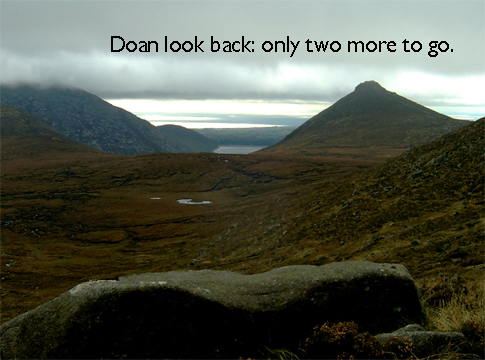
Picture: Tough old mutton dressed as Lamagan
Bleck Cra on Slievelamagan
by Bleck Cra
20 Jul 2006
There he was, leader of men and lumbering helplessly into me, circa the summit of Lamagan: nasal system at meltdown, sweat beading on each earlobe and doing that thing black dogs do in the sun - human beings think it is a smile, but it’s not: it’s a teeth-filter for bugs, as the critter gags for oxygen. The teeth tried to open, but couldn’t and he made a sort of bleating/pleading/dying noise as he floundered on. The objective was to out-walk his wards - age 15 and such - and at the guts of 50 years despite 30 of them in the hills, he had no chance against elastic legs, balloon lungs and innocent determination. And that in some ways is what Slievelamagan is about. The incline on her sultry Southern face is not to be messed with. An advance and rewarding canter off Binnian puts you in the mood for more. Lamagan disabuses you of that. If you are fool enough to maintain a momentum, you will sicken at best, a third of the way up and wish you hadn’t scoffed the cheese sandwiches 20mins earlier. She’s a big oul girl and only the mad or the bad will do her in one lash, that is to say without dropping to their knees for mercy. Postcard pics of the Mournes tend to hide her behind something else. Here be Binnian, here be Bearnagh, here be Donard. Where be Lamagan? Sure, right here under your feet where those sandwiches have just come up. The slabs off her Eastern crags are stupendous and unsettle the best of us, the damp sandy gullies and red peat plugs off her Northern slopes are odd and wonderful and her Western flanks are generally untrailed. Best from Carrick Little and a protein breakfast, much earlier. Linkback: mountainviews.ie/summit/106/comment/2438/
Read Less
Read More
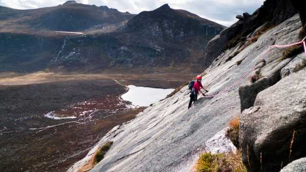
Picture: Spiderwoman (Kernowclimber) on FM
Rock on!
by mcrtchly
4 Oct 2010
Having walked up Slieve Lamagan the previous weekend we decided that a more challenging ascent would be fun. With this in mind an attempt on a rock climbing route was called for and FM on the Lamagan slabs fitted the bill. FM (rated V. Diff) is one of the longest multi-pitch routes in the Mournes with about 160m of direct climbing and another 200m or so of grade 1/2 scambling and walking to reach the top of Slieve Lamagan. The Lamgan slabs can be seen on the walk-in from the Carrick carpark and at first sight appear to rear-up as an amost vertical un-climable wall. Fortunately this is an optical illusion created by the perspective of the view from the footpath for upon reaching the foot of the slabs their true nature becomes apparent.
The start of the climb can be reached by taking the footpath eastwards around the foot of Percy Bysshe before turning northwards to reach a path running along the foot of Slieve Lamagan. Follow this path eastwards again until a faint path at C (J33250 24877) can be taken up the boulder and heather clad footslopes of Lamagan. The rock climb begans at the foot of a white slab in a small gravel floored embayment at D (J33159 25480). I won't describe the climb in detail as there is a good description in the recently published book on 'Rock Climbs in the Mourne Mountains'. But some points to note are: the rock is generally good and clean (mostly 45-55 degree slope), some parts are mossy and rock shoes are recommended; the crux is a step up onto a sloping ledge on the third pitch (this was wet on the day of our climb and I traversed left below the ledge for about 7m and then climbed a short overhanging wall to step back above the sloping ledge); protection is generally good but there are long run-outs on the slabs for the leader (an uncontrolled slide down the slabs wouldn't be pleasant).
There is a commanding view of the Annalong valley during the climb with the floor of the valley appearing almost as a map beneath us. Every so often the minute moving dots of walkers could be seen on the paths below us, occasionaly stopping to watch our progress up the rock face.
FM is an excellent and airy route, perhaps not on the alpine scale of Carrot Ridge, but certainly a bit harder and more commiting that than the latter. A 50m-60m rope and a selection of slings and hexs are required. Linkback: mountainviews.ie/summit/106/comment/6123/
Read Less
Read More
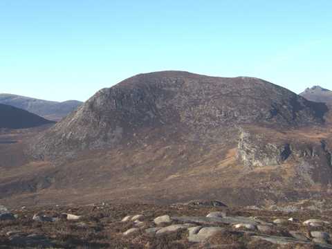
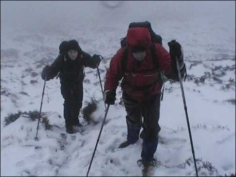
Picture: It was a snowy day on lamagan
deelambola on Slievelamagan
by deelambola
15 Feb 2007
After many summer climbs of lamagan, it was decided to tackle a winter ascent. After slipping up the road even on the way to the car park we dawned our wet gear as the mist rolled in and the sky turned dark. Walking up the path along annolong wood it was clear to see winter had taken its toll, what once was a track during the summer was now a full scale flowing river. Wading on we hit the bottom of lamagan and began our ascent which quickly became a climb in two feet of snow. The visibility was practically zero but the adrenalin thrill of the snow made it worth while. The summit was reached but there would be no lunch stop today as the blizzard blinded the eyes and all extremities were frozen. We descended towards Ben Crom and walked along silent valley back towards the car. A cold but enjoyable day. Roll on next week. Linkback: mountainviews.ie/summit/106/comment/2619/
Use of MountainViews is governed by conditions and a privacy policy.
Read general information about the site. Opinions in material here are not necessarily endorsed by MountainViews.
Hillwalking is a risk sport. Information in comments, walks, shared GPS tracks or about starting places may
not be accurate for example as regards safety or access permission. You are responsible for your safety and your permission to walk.
See the credits and list definitions.


 Our Facebook page.