This website uses cookies, which are small text files that the website puts on your device to facilitate operation. Cookies help us provide a better service to you. They are used to track general user traffic information and to help the website function properly.
Feature count in area: 19, all in Mayo,
OSI/LPS Maps: 22, 23, EW-WNN
Highest Place: Maumakeogh 379m
Starting Places (9) in area North Mayo: Bangor Trail Head, Carnhill, Carrowmore Wood, Erris Head, Portacloy Bay, Proesoon, Sralagagh West, Termon Hill Road, Tower Hill South
Summits & other features in area North Mayo: Cen: Pulathomas: Barnacuillew 260m E: Ballycastle Hills: Knockaghaleague 237m, Knockboha 186m, Maumakeogh 379m N: Benwee Head Cliffs: Benwee Head 255m, Barradeegin 229m, Glinsk 304m, Illanmaster 238m, Illanmaster Island 105m, Porturlin Hill 155m, Srahataggle 182m, Tawnaghmore 340m S: Bangor Erris Hills: Carrafull 269m, Knocklettercuss 370m, Knocknascollop NW Top 244m, Sheean 295m, Slieve Fyagh 335m W: Belmullet: Aghaglasheen 132m, Termon Hill 103m
Note: this list of places may include island features such as summits, but not
islands as such.
Knocknascollop NW Top, 244mHill Cnoc na Scolb (mullach thiar thuaidh) A name in Irish,
Place Rating ..
(prob. Ir. Cnoc na Scolb [PDT], 'hill of the scollops'), Mayo County in Connacht province, in Binnion Lists, Knocknascollop NW Top is the 1293th highest place in Ireland.
Grid Reference F80129 29787,
OS 1:50k mapsheet 22 Place visited by: 11members, recently by: FilHil, eamonoc, TommyV, Fergalh, Garmin, harry66, sandman, chalky, IncaHoots, Big-Foot, fir-na-laighin
I visited this place: NO (You need to be a logged-in member for this.)
Longitude: -9.837718, Latitude: 54.203005, Easting: 80129, Northing: 329787,
Prominence: 231m, Isolation: 7.8km ITM: 480105 829791 Bedrock type: Banded, graded and X-bedded quartzites., (Bangor/Corslieve Formation) Notes on name: This hill, which is the highest point on a ridge consisting of three peaks, is unnamed on OS maps. However, the name Knocknascollop is given for the SE peak on the Discovery map, and on William Bald's map of Co. Mayo (1830) the NW peak is marked Knock-na-Skalib (effectively the same name), showing that this name applies to the whole ridge. Scollops are looped sticks used to secure thatch on a roof. The name probably refers to the notched appearance of the ridge. Previously Carrowmore Hill in MV.
Short or GPS IDs, 6 char: Knc244, 10 char: KncknsNWTp Linkback: https://mountainviews.ie/summit/1006/
Gallery for Knocknascollop NW Top (Cnoc na Scolb (mullach thiar thuaidh)) and surrounds
No summary yet for this place
.
Add a Place Comment for Knocknascollop NW Top, Cnoc na Scolb (mullach thiar thuaidh) (1006) in Area: North Mayo, S: Bangor Erris Hills, County: Mayo, S: Bangor Erris Hills
Member Comments for
Knocknascollop NW Top (Cnoc na Scolb (mullach thiar thuaidh))
Decent views of Carrowmore Lake make this climb worth while. I parked at a clearing by the roadside at A (F80897 26653) and walking down a lane towards the hill at B (F80927 26745). There is a concrete bridge at C (F81402 26823) to get across a stream. After this, there is no clear track to follow, so I just headed straight up for the summit cairn at D (F82119 27540). This is not the true summit, as there is a higher point about 3km away 5m higher. I had no time to walk out to this point, as night was falling. I'll have to bag this point another time to truthfully have reached the summit. Linkback: mountainviews.ie/summit/1006/comment/3813/
Read Less
Read More
Picture: Summit Area.
True Summit.
by sandman
5 May 2015
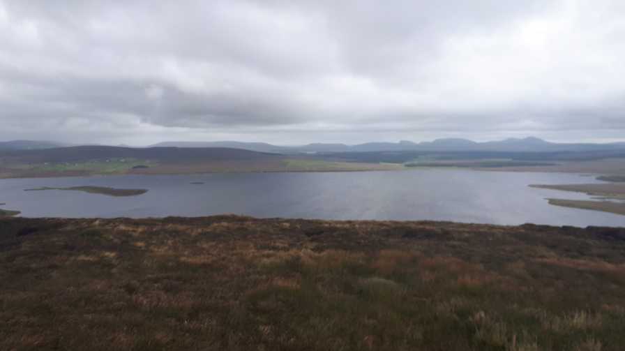
As mentioned in the previous comment the NW Top is 5m higher than Knocknascollop which has a large cairn on top.Easy access to this top is via a rough farm tract at E (F80897 30646) with parking 40m further on towards the lake on the same side. Although this tract runs out it will bring you close to the summit at F (F80129 29787) . Underfoot conditions good with lake and ocean views. Linkback: mountainviews.ie/summit/1006/comment/17973/
Read Less
Read More
Picture: Looking Down on Carrowmore Lake
The unofficial high point.
by TommyV
9 Sep 2019
This route actually takes in the cairn on Knocnascallop and not the NW top which is five metres higher. My plan was to take in the NW top but after driving around it seemed that parking and access for Knocknascallop proper was much easier. There is a carpark at Carrowmore Lake lake at G (F83035 28297). From here follow the road South for a couple of hundred metres until you see a good place to head out onto the open hillside. From here it's little over a kilometre climb to the cairn at the summit. If you have time you could make a ridge walk over to the NW top and drop down to the road following the lake back to the carpark. As I had climbed a few other hills in the area earlier that day, I did not have the will or the energy to do this. For the sake of five metres, I'm claiming this one. Linkback: mountainviews.ie/summit/1006/comment/20650/
Use of MountainViews is governed by conditions and a privacy policy.
Read general information about the site. Opinions in material here are not necessarily endorsed by MountainViews.
Hillwalking is a risk sport. Information in comments, walks, shared GPS tracks or about starting places may
not be accurate for example as regards safety or access permission. You are responsible for your safety and your permission to walk.
See the credits and list definitions.


 Add a Place Comment for Knocknascollop NW Top, Cnoc na Scolb (mullach thiar thuaidh)


 Our Facebook page.