Members and Supporters, the MountainViews Committee requests your help to meet the costs of the website and of other activities such as insured events or publications.
Feature count in area: 3, all in Kerry,
OSI/LPS Maps: 63, 71
Highest Place: Crusline 355m
Starting Places (1) in area North Kerry: Tursillagh Wind Farm
Summits & other features in area North Kerry: N: Ballybunion: Knockanore 265.5m S: Stacks Mountains: Crusline 355m W: Ballyheigue: Maulin Mountain 217m
Note: this list of places may include island features such as summits, but not
islands as such.
Knockanore, 265.5mHill Cnoc an Fhómhair A name in Irish,
Place Rating ..
(Ir. Cnoc an Fhómhair [logainm.ie], 'hill of the autumn'), Kerry County in Munster province, in Binnion Lists, Knockanore is the second highest hill in the North Kerry area and the 1251th highest in Ireland. Knockanore is the most northerly summit in the North Kerry area and also the most easterly.
Grid Reference Q91005 42559,
OS 1:50k mapsheet 63 Place visited by: 34members, recently by: chelman7, JohnRea, Lauranna, liz50, Fergalh, madfrankie, Eileen-Dad, TommyV, wicklore, jackill, Geo, hivisibility, Carrauntoohilboy, chalky, la1ena
I visited this place: NO (You need to be a logged-in member for this.)
Longitude: -9.606576, Latitude: 52.523899, Easting: 91006, Northing: 142559,
Prominence: 252m, Isolation: 15.7km, Has trig pillar
ITM: 490979 642605 Bedrock type: Mudstone, siltstone & sandstone, (Shannon Group) Notes on name: The Irish form on the Discovery map is different from that found at logainm.ie: Cnoc an Óir, 'hill of the gold'. Knockanore is said to have been the scene of a great slaughter in ancient times. [OSNB] Tis said that there was a great monument erected in memory of the slaughter in the spot where the trigl. Station stands; it was called Lact na Fulla. [OSNB] This battle is mentioned in O'Sullevan Beare's Historiae Catholicae Iberniae Compendium. The tradition of a great battle is based on the intrepretation of the name as Cnoc an Áir [OSNB, OG], 'hill of the slaughter'.
Short or GPS IDs, 6 char: Knc266, 10 char: Knockanore Linkback: https://mountainviews.ie/summit/984/
Gallery for Knockanore (Cnoc an Fhómhair) and surrounds
Summary
for Knockanore (Cnoc an Fhómhair):
Poor foreground, excellent background
Summary created by Peter Walker
2012-06-15 12:43:04
A tortured summit with a fine panoramic view, Knockanore looms large over the golfing Mecca of Ballybunnion.
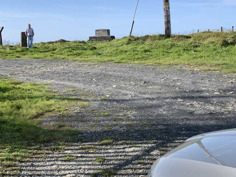
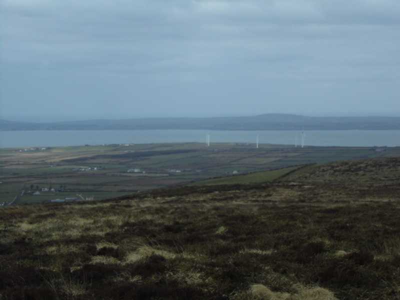
As it is possible to drive to within a few yards of the summit any challenge in climbing it involves in-car rather than on-foot navigation. Take the R551 north out of Ballybunion, turning right at A (Q896 437), then right again at B (Q905 434), before finally turning left at C (Q903 424) onto the steep access road. The summit is adorned with assorted radio flotsam and jetsam (which is itself emblazoned with some rather choice graffiti regarding the inhabitants of Ballybunnion), a triangulation column, and a split level concrete pillar which marks the actual highest point. The mess is unfortunate, but the view is excellent: a superb place for taking in the scale of the Shannon as it empties into the sea.
Picture: Well, I wasn't going to put up a pic of the graffiti about Ballybunion, was I?
Peter Walker on Knockanore
by Peter Walker
17 Dec 2009
After the previous day in the Knockmealdowns had become a minor epic of mist and gale-force winds, of pitch darkness and headtorches, and astronomy...there's are definite benefits to Knockanore. As Mr Three5four0 says, you can drive to the summit, parking either as he mentions before the final bend on the access road, or being impossibly lazy and going right to the end of the road from where it must be a good ten yards or so to the highest point (the split-level concrete pillar rather than the triangulation column).
It's a tortured summit to be sure, both in the major (all the ancient telecomms paraphernalia) and minor (see photo) details, but as the highest thing for a large distance it does score highly as a viewpoint: miles and miles of coastline and acres and acres of lush farmland are arrayed for your contemplation. Coming as I do from England (where we don't have proper rivers) I especially noted the scale of the Shannon as seen from here: broad and majestic indeed.
The pic is the latest in my acclaimed series of shots of 'great pieces of flytipping in the Irish Hills': those trig points can be really uncomfortable to lean against, so we must thank the kind-hearted soul who left that car seat there. Linkback: mountainviews.ie/summit/984/comment/4298/
Read Less
Read More
Picture: Tough climb to the trig point from the car!
An easy summit bag
by liz50
26 Sep 2020
Having visited the only other summit in the North Kerry group, Maulin we then tackled the highest which is 265m tall and must be the easiest summit to bag!. Following the directions given in earlier comments it was a pleasant stroll of 40m from car to trig point. Linkback: mountainviews.ie/summit/984/comment/20904/
Read Less
Read More
three5four0 on Knockanore
by three5four0
16 Sep 2009
You can drive right to the summit of Knockanore if you so wish. There is a parking area just before the access road doubles back on its self, which leaves a short stroll up tarmac to the summit & trig point. There is debris of the telecommunications age on the summit, which, some rival wag has covered in writing calling in to question the character of the Ballybunnion residents below. Linkback: mountainviews.ie/summit/984/comment/4108/
Read Less
Read More
What a view!!
by atlantic73
14 Jul 2014
You can drive all the way to the viewpoint or walk about a mile from the main road. For such a small hill the view is simply stunning. Well worth a visit if in the area Linkback: mountainviews.ie/summit/984/comment/17551/
Read Less
Read More
Picture: Looking out on the Shannon estuary with the Loop Head peninsula in the background.
Easy bag.
by TommyV
2 Nov 2018
This hill in North Kerry is the highest point in the region so there are some nice views over the Shannon estuary. There is a road leading all the way to the top, so I bagged this one by driving to the top as per Peter Walkers directions. You can actually touch the trig point with your car. Linkback: mountainviews.ie/summit/984/comment/20152/
Use of MountainViews is governed by conditions and a privacy policy.
Read general information about the site. Opinions in material here are not necessarily endorsed by MountainViews.
Hillwalking is a risk sport. Information in comments, walks, shared GPS tracks or about starting places may
not be accurate for example as regards safety or access permission. You are responsible for your safety and your permission to walk.
See the credits and list definitions.


 Our Facebook page.