[RWD version 1 ]
In view of the COVID-19 warnings, we decided to pick an out of the way route that would hopefully provide plenty of solitude. However, the day was so enviting that there were throngs of walkers out on the tracks.
The starting point has sufficient space for six vehicles. Head in the excellent forest road for 1.2Km until you come to a fire break on your left. Head up this break for 200m until the saddle is reached. There is another fire break to your left heading due south west. Head along this break for 300m. The old top of
Slieve Maan will be reached first but the highest point, indicated by some upright stones, is about 30m furrther on to your left in the trees.
Retrace your steps to where you entered this fire break and continue due north along the extraction track for 900m until another fire break is reached. Swing in to your right and after about 100m and you will see the non-descript
Slieve Maan North Top marked by a pile of stones at the far side of the clearing.
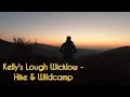
Taking care, head north east for 200m through some mature pine forest which is not too difficult. You will meet up with another fire break. Follow this track, to the right, all the way down to join the Wicklow Way track. Head left along this track for 1Km, (should you wish, it is posible to do a side track up north west to Kelly's Lough from a point just along here), only leaving it at a sharp bend where the Wicklow Way heads left and instead head down south west to join the Military Road.
Follow the Military Road down left for 900m to reach a forest extraction road on your right. Head in here, over the bridge and turn left at the first gate along the track for 100m until you see a good track heading up south east straight up onto the saddle. On reaching the saddle, a clear track heads north east to the top of
Fananierin. The views from this point are truly spectacular. Having fully enjoyed this promontory retrace you steps and head directly south west along the ridge, following a reasonably good track.
(
WHY? Can someone please explain why people with morotised trail bikes love carving up these soft turf tracks. There is extensive damage all over this Fananierin to Croaghanmoira Ridge. The tyres gouge up to one foot deep into the root systems. Surely there are designated areas where they can enjoy their sport?)
At the end of this ridge it is hard to spot
Croaghanmoira North Top and if you are not careful you could pass close by it just like me! At the end of the track swing left at the T-junction. Follow the well defined track up onto
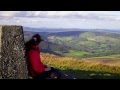
Croaghanmoira. Again the views from the top are hard to beat. For what it is worth, I was told that the Trig. Point here was the very first one to be installed in Ireland. Certainly from here you can easily spot Lugnaquilla and Turlough Hill.
Getting back to the start is just a matter of retracing your steps to the T-junction and continuing down to the finish point.


 Our Facebook page.