If you want to use the website often please enrol (quick and free) at top right.

Benbaun 729m, Benbreen 691m, Benbreen Central Top 680m, Benbreen North Top 674m, Bengower 664m, Muckanaght 654m, Benfree 638m, Bencullagh 632m, Maumonght 602m, Benbrack 582m,

 Get Notifications
A visit to Tievummera via its South East spur.
 simon3
Ben Creggan: Craggy summit with long descending spur to the east.
 Collaborative entry
Teevenacroaghy: Misty Achill.
 simon3
Dorinish More: Shapely islands in Clew Bay, Co Mayo.
 simon3
Crott Mountain: Quiet Arderin at the east end of the Croagh Patrick ridge.
 Collaborative entry
Teevenacroaghy: A heathery ridge bump with good views.
 Collaborative entry
Teevenacroaghy: A clear day on the Hill
 three5four0
Madeira: From Pico Arieiro to Pico Ruivo
Madeira: Coastal/Cliff walk to the Eastern Edge
Madeira: Descent from Monte to Funchal
Hag's Tooth: This might hurt
 No1Grumbler
Galtymore: Dawn on Galtymore
 DeirdreM
Use of MountainViews is governed by conditions and a privacy policy.
Read general information about the site.
Opinions in material here are not necessarily endorsed by MountainViews.
Hillwalking is a risk sport. Information in comments, walks, shared GPS tracks or about starting places may not be accurate for example as regards safety or access permission. You are responsible for your safety and your permission to walk.
See the credits and list definitions.
 Visit our Facebook page.
 Length: 8.4km, Creator time taken: 4h , Ascent: 616m,
Descent: 619m
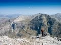
Places: Start at L7413051330, An Chailleach, Maumonght, Binn Bhreac, end at Start
Logged as completed by 1

However, doing this on the official "hottest day of the year" meant that whenever the wind dropped it didn't take long for thousands of blood crazed midges to find us. I think this may have been the first time I've been sitting on a summit just praying for wind so that I could eat in peace. It's a good thing I had my head net! This was possibly my first experience of a wind free summit in the 12-bens region.
Views when you come to the saddle are fantastic, and for most of the walk to your east you'll enjoy the 12-bens, and to your west you'll have views out to Inisboffin, Clare island and Achill island.
NOTE: ALL information such as Ascent, Length and Creator time taken etc should be regarded as approximate. The creator's comments are opinions and may not be accurate or still correct.
Your time to complete will depend on your speed plus break time and your mode of transport. For walkers: Naismith's rule, an approximate though often inaccurate estimate, suggests a time of 2h 43m + time stopped for breaks
NOTE: It is up to you to ensure that your route is appropriate for you and your party to follow bearing in mind all factors such as safety, weather conditions, experience and access permission.
* Note: A GPS Height in the elevation profile is sourced from the device that recorded the track. An "SRTM" height is derived from a model of elevations for parts of the earth. More detail![]()
|
|
|
||
| MountainViews.ie, a Hill-walking Website for the island of Ireland. 2400 Summiteers, 1480 Contributors, maintainer of lists: Arderins, Vandeleur-Lynams, Highest Hundred, County Highpoints etc | |||