Cookies. This website uses cookies, which are small text files that the website puts on your device to facilitate operation. Cookies help us provide a better service to you. They are used to track general user traffic information and to help the website function properly.

Click to hide this notice for 30 days.
Welcome to MountainViews
If you want to use the website often please enrol (quick and free) at top right.
Overview
Detail
Zoom: ??
For more map options click on any overview map area or any detail map feature.
Find Suggested Walks
Find hill, mountain, island, coastal feature.
Videos


Recent Contributions
Get Notifications

Knocklettercuss: Ascend via the spur

Dún Briste: You must be joking

Doonvinalla E Top: Portacloy Cliff Walk

Erris Head Hill: Fantastic loop

Aghaglasheen: Highest point on the peninsula

Burren: Black Head Loop

Carrigroe: Twin tops

Letterettrin - a perspective on the N Connemara peaks

Grieve Hill: Summit position recently revised.

Kilbrony Park Ramble

Leean Mountain: Ireland's Best Small Hill?

Scarr North-West Top: Popular spot in the heart of the mountains

Conditions and Info
Use of MountainViews is governed by conditions and a privacy policy.
Read general information about the site.
Opinions in material here are not necessarily endorsed by MountainViews.
Hillwalking is a risk sport. Information in comments, walks, shared GPS tracks or about starting places may not be accurate for example as regards safety or access permission. You are responsible for your safety and your permission to walk.
See the credits and list definitions.
Video display
Trailtrekker: Track 2686 in area near Ballinacor Mountain, Dublin/Wicklow (Ireland)
Croaghanmoira & 3 Neighbours Loop
Length: 20.5km, Creator time taken: 5h48m, Ascent: 909m,
Descent: 904m

Places: Start at T0855786734, Ballinacor Mountain, Croaghanmoira, Croaghanmoira North Top, Fananierin, Slieve Maan, end at Start
Logged as completed by 1

This is a route that I can happily recommend... well the first 3/4 of it anyway!! With two cars it can be significantly shortened, I will give the reasons why I wouldn't cut the first part, but would cut the last!

The first section 6km/1 hour starts off on not unpleasant forestry tracks and a very quiet and scenic road. I found that a lot of the forestry tracks that show up on the OSi map are not actually there, but still managed to negotiate the forest without having to back track. In early autumn the colours on the hillside as you walk the road to the bottom of Ballinacor were beautiful. This stretch is a good warm up before starting the first real ascent of the day.

I choose a direct trackless approach to the top of Ballinacor, going through heather and high ferns. I suspect that there might be a better track to the left of my approach, following the right hand side of the Ballycreen Brook to near it's source before heading for the top from the west. From the top of Ballinacor I dropped down the far side, again through rough ground, before joining a well defined mountain track. From this point until Fananieren it is a very pleasant walk on good terrain and gentle slopes, and well defined mountain track, going in a horseshoe route above the valley, although by the looks of it, some of it could be very boggy at a wetter time of year.

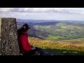
Fananierin turned out to be a surprising highlight of this walk, with great views back to Croaghanmoira, into the Ballinacor estate, Drumgoff barracks and up the Glenmalure glacial valley. From the summit, this route then backtracks on itself for a small distance before turning right, one fence crossing before walking down the field to the gate and back out onto the Drumgoff to Aghavannagh road.

If you have a second car, this is where I would recommend parking it (near T10187 89257). As the last part of this route is along ugly forestry track, through a forest break and road, it does take you over the true summit of the horrible little **** of a hill that is Slieve Maan though. A hill that I will not be revisiting.

In summary, great walk apart form the last stretch!

Uploaded on: Sun, 7 Sep 2014 (16:49:11)
Linkback: https://mountainviews.ie/track/2686/  
To download GPS tracks you must be enrolled and logged in. See "Login or enrol", top right - quick and easy.


COMMENTS
No comments uploaded yet.

NOTE: ALL information such as Ascent, Length and Creator time taken etc should be regarded as approximate. The creator's comments are opinions and may not be accurate or still correct.
Your time to complete will depend on your speed plus break time and your mode of transport. For walkers: Naismith's rule, an approximate though often inaccurate estimate, suggests a time of 5h 37m + time stopped for breaks
NOTE: It is up to you to ensure that your route is appropriate for you and your party to follow bearing in mind all factors such as safety, weather conditions, experience and access permission.

* Note: A GPS Height in the elevation profile is sourced from the device that recorded the track. An "SRTM" height is derived from a model of elevations for parts of the earth. More detail

Main mapping:
Open Street Map
(Main supplier OpenTopoMap)
Height layer: © MapTiler
MapTiler Logo
British summit data courtesy:
Database of British & Irish Hills
(Creative Commons Licence)
MountainViews.ie, a Hill-walking Website for the island of Ireland. 2500 Summiteers, 1480 Contributors, maintainer of lists such as: Arderins, Vandeleur-Lynams, Highest Hundred, County Highpoints etc